The Minister of Environment, Conservation and Parks (MECP) has provided approval to advance the project with the requirement of two additional studies during detailed design that must be provided to the Ministry prior to commencing construction.
Originally a 1.4 km gap in the Humber River Trail (HRT) near Weston Road and Lawrence Avenue West, approximately 800 metres of trail remains to be completed. This gap constitutes a significant barrier to a continuous multi-use trail system both along the HRT and in the future Loop Trail. The Loop trail is a 65 km off-road, multi-use ring that will connect multiple ravines, neighbourhoods and trail systems throughout Toronto. Existing routes present safety concerns to users who are forced to detour along busy local roads that lack designated cycling infrastructure and are not fully accessible.
The study is being conducted in partnership by Toronto and Region Conservation Authority (TRCA) and City of Toronto.
On December 8, 2023, the Minister of the Environment, Conservation and Parks (MECP), Andrea Khanjin, provided the City approval to advance the project with the requirement of two additional studies during detailed design that must be provided to the Ministry prior to commencing construction – a safety plan that satisfies the requirements of emergency services, and a flood and ice jam mitigation plan.
Next, staff will confirm budget and resourcing in order to advance this project into the next phase of detailed design and implementation. An update will be shared once a schedule is confirmed.
On January 18, 2023, the Ontario Minister of Environment, Conservation, and Parks issued an order requiring that the City of Toronto and Toronto Regional Conservation Authority carry out an individual environmental assessment for additional study.
City staff reported to City Council on March 8, 2023, about the status of the Mid-Humber Gap project, seeking authority for the City to apply to the Court for judicial review of the matter. The report can be found here: Legal Advice in response to Provincial Order Requiring Individual Environmental Assessment for new Multi-Use Trail.
As such, the City commenced a Notice of Application for Judicial Review in Divisional Court challenging the Province’s order for further study on the Mid-Humber Gap Trail however the Minister agreed to a consent order from the Court setting aside the order issued on January 18, 2023.
The project was then remitted back to the Minister for reconsideration and a decision within 30 days of the November 8, 2023, Divisional Court Order.
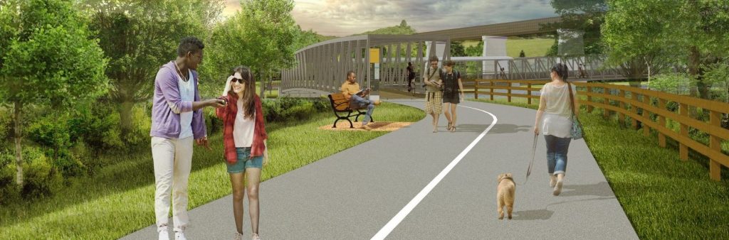
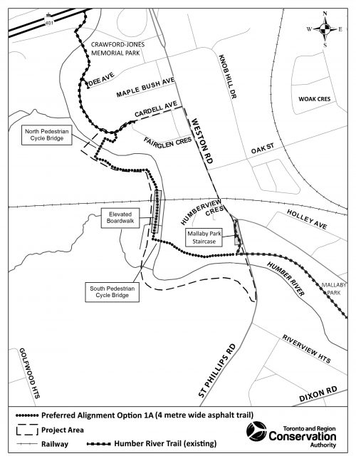
Public review of the Mid Humber Gap Trail Final Report is complete. The Preferred Trail Alignment, as documented in the final report, includes an in-valley alignment, paved multi-use trail, including two pedestrian-cycle bridges with an elevated boardwalk. The next steps include the final phase of planning, detailed design and continued engagement with local stakeholders.
Following all approvals, including Toronto City Council, Ministry approval for the MCEA, and negotiation with the impacted private landowners, detailed design timeline is pending outcome of judicial review of Province request for further study through an Individual Environmental Assessment. This will be a multi-year project with construction taking two to three years until completion.
The Detailed Design phase will include, but is not limited to:
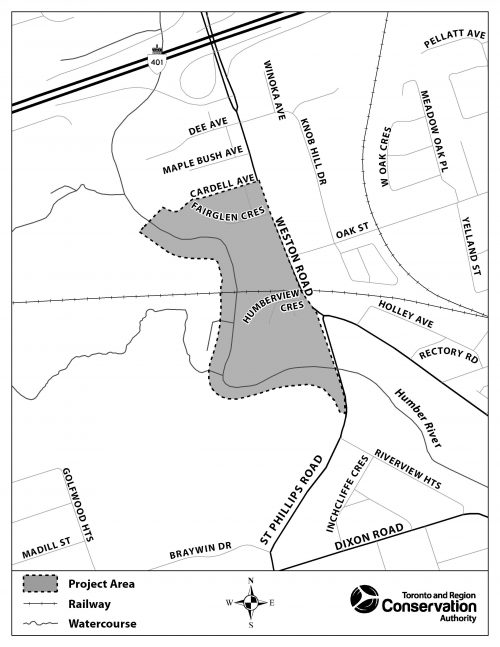
The City of Toronto in partnership with the Toronto and Region Conservation Authority (TRCA) has completed a Municipal Class Environmental Assessment study that evaluated options and identified a preferred trail alignment that will close the existing 800 metre gap in the Humber River Trail (HRT) network just south of Mallaby Park at St. Phillips Road and the southern entrance to Crawford-Jones Memorial Park off Cardell Avenue near Weston Road.
Existing routes present safety concerns to users who are forced to detour along busy local roads that lack designated cycling infrastructure and are not fully accessible. Closing this remaining gap will provide for a continuous multi-use trail both along the HRT and in the future Loop Trail. The Loop trail is a 65 km off-road, multi-use ring that will connect multiple ravines, neighbourhoods and trail systems throughout Toronto.
The preferred trail alignment, as documented in the final report, includes an in-valley alignment, paved multi-use trail, including two pedestrian-cycle bridges with an elevated boardwalk. City and TRCA staff will continue to consult with local stakeholders during the next phase of detailed design.
The study has been carried out under Schedule ‘B’ of the Municipal Class Environmental Assessment, which is an approved planning process under the Ontario Environmental Assessment Act.
The study report was placed on public record for a 30-day review period from October 20 to November 19, 2022. It is available for review on this web page under the Final Report tab.
On July 7, 2022, the Infrastructure & Environment Committee (IEC) endorsed IE31.11 – staff recommendations for the preferred trail alignment, an in-valley option.
On July 19, 2022, City Council adopted the preferred in-valley trail alignment that will close the existing gap in the Humber River Trail network and authorized the City to file the Mid Humber Gap Environmental Assessment (EA) Notice of Completion and post the study report for a 30-day review period. A copy of the staff report is available under IEC agenda item IE IE31.11.
Public consultation is an important element of the study. You will have opportunities for input at key stages throughout the project. Information about future public consultation events will be distributed by mail and posted here. If you have questions or comments, or would like to receive email project updates, please contact us at 416-338-2850 or email maogosha.pyjor@toronto.ca
The Mid Humber Gap project area is located between two completed sections of the Humber River Trail (HRT) just south of Mallaby Park and west of St. Phillips Road and the southern entrance to Crawford-Jones Memorial Park off Cardell Avenue.
Consultation for the Mid Humber Gap Trail has engaged a broad range of residents, businesses, and stakeholders over two rounds of engagement.
The City hosted a virtual public meeting on June 10, 2021 from 6:30 p.m. to 8:30 p.m. The meeting was attended by 77 participants who contributed to a very thoughtful and informative discussion.
Project team members presented on the study background, process and potential trail alignments. Three potential trail alignments were highlighted: in-valley (1A); hybrid in-valley and on-road (2A) and on-road (3A)..
The City hosted a virtual public meeting on May 17, 2022, from 6:30 p.m. to 8:30 p.m. The meeting was attended by 89 participants who were invited to provide feedback and ask questions.
Project team members presented on the preferred trail alignment in-valley (1A).
A Stakeholder Advisory Group (SAG) comprised of stakeholder representatives and local residents was formed to review and provide feedback throughout the Environment Assessment process. The SAG assists in building a consensus on the Mid Humber Gap’s primary objective – to identify a preferred multi-use trail alignment for the remaining approximately 800 metre gap in the Humber River Trail (HRT).
The City and TRCA presented to the SAG on Wednesday, May 5, 2021, on the SAG Terms of Reference, project background, Municipal Class Environmental Assessment process, planning context, preliminary screen matrix, and project timeline.
The City and TRCA presented to the SAG on Thursday, February 3, 2022, on the Preliminary Preferred Trail Alignments, Evaluation Matrix and Design Considerations for Preferred Alignment. The following key topics and staff response were discussed.
Private Land Trust and location of trail from individual’s homes
Weston Golf and Country Club (WGCC) and potential safety risks, trail users and flood events and mitigation
Preferred Trail Alignment and maintenance
Bike Lane Considerations for Weston Road and facility options
Trail Accessibility considerations
Flooding and Erosion assessment inquiry
Construction commencement
The Mid Humber Gap Project was one of 26 projects identified in the Bikeway Trails Implementation Plan adopted by Toronto City Council in 2012 and a near-term priority in the 2019 Cycling Network Plan Update.
In 2013, the City and Toronto & Region Conservation Authority (TRCA) completed Stage 1 of the Mid Humber Gap project. During Stage 1, a 600-metre trail was constructed to connect Mallaby Park to the HRT system and a pre-existing dirt trail was formalized into a 3.5 metre-wide paved multi-use pathway.
In 2019, the City and TRCA completed Stage 2 of the Mid Humber Gap project to evaluate conceptual trail alignment options to close the remaining gap of approximately 800 m in the HRT between Mallaby Park and Crawford-Jones Memorial Park.
The Feasibility Study provides a project rationale for pursuing Stage 3 – Municipal Engineer Class EA (MCEA) Schedule B Planning Process. The Feasibility Study evaluated a range of conceptual trail alignments, culminating in a recommended “in-ravine” and “on-road” option.
Trail alignment constraints include steep grades, challenging topography and private property considerations. These constraints increase the complexity of the project and may require construction of bridges, boardwalk structures and negotiations with private landowners. The Feasibility Study also confirmed the need to conduct a more thorough investigation via an MCEA Schedule B process.
The Mid Humber Gap is currently in Stage 3 and subject to MCEA Schedule B requirements.
Building off the work already completed as part of a Feasibility Study undertaken in 2019, the planning and design of the Mid Humber Gap will follow the Schedule B requirements for a Municipal Engineer Class EA (MCEA) process. The MCEA meets the intent of the EA Act by providing for the identification of problems or opportunities; giving due regard to the need to protect the environment and minimize effects; and consulting with affected stakeholders early and throughout the decision making process (Municipal Engineers Association, amended 2015).
The study will consider the following items to determine the location and alignment for the new trail connection:
Following the first virtual Stakeholder Advisory Group and Public Meeting, the potential connection options will be evaluated and a preferred alternative will be recommended based on the outcome of the evaluation and public feedback.
Information used in the evaluation will be collected through existing reports, field studies, input from technical advisors and subject matter experts and through public consultation.
All potential alignments for the multi-use trail, both individually and collectively, will be studied in order to provide a preferred trail alignment to complete approximately 800 metres of the Humber River.
The preferred trail alignment will be decided as per a formal Environmental Assessment (EA) process and followed by design/construction programmed in future years (based on budget ability).
Some of the potential multi-use trail alignments that are being proposed could involve impacts to residential and commercial properties. In some cases, the potential impact is to the City-owned right of way.
The owners of properties that are potentially impacted by multi-use trail alignments will be engaged with directly by the City of Toronto and Toronto & Region Conservation Authority (TRCA).
Private property impacts will be considered as part of the detailed evaluation criteria used to determine the recommended alignment.
The study has been carried out under Schedule ‘B’ of the Municipal Class Environmental Assessment, which is an approved planning process under the Ontario Environmental Assessment Act. A Final report was available for a 30-day review period from October 20 to November 19, 2022. See Notice of Study Completion.
Chapter 2 Environmental Assessment Process
Chapter3 Consultation Strategy
Chapter4 Planning Context and Opportunity Statement
Chapter 5 Existing Conditions Part 1
Chapter 5 Existing Conditions Part 2
Chapter 6 Evaluation of Trail Alignment Concepts
Chapter 7 Alternative Design Concepts for Preferred Trail Alignment
Chapter 8 Description of Preferred Trail Alignment Concept
Chapter 9 Environmental Impacts and Mitigation
Chapter 10 Permits and Approvals
Chapter 12 Potential for Future Amendment
For a copy of any of the appendices, please contact us.
Need assistance? While we aim to provide fully accessible content, there is no text alternative available for some of the content on this page. If you require alternate formats or need assistance understanding our maps, drawings or any other content, please contact us at 416-338-2850 or email maogosha.pyjor@toronto.ca