The City, in cooperation with Toronto and Region Conservation Authority (TRCA), is restoring the Mud Creek Inlet at Don Valley Brick Works (DVBW) Park.
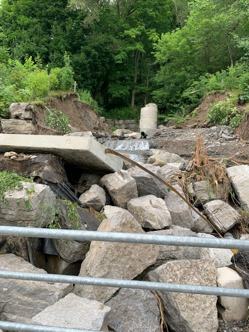
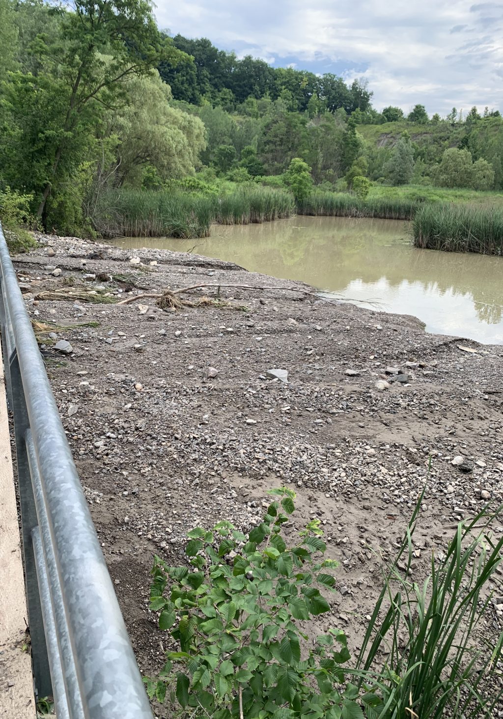
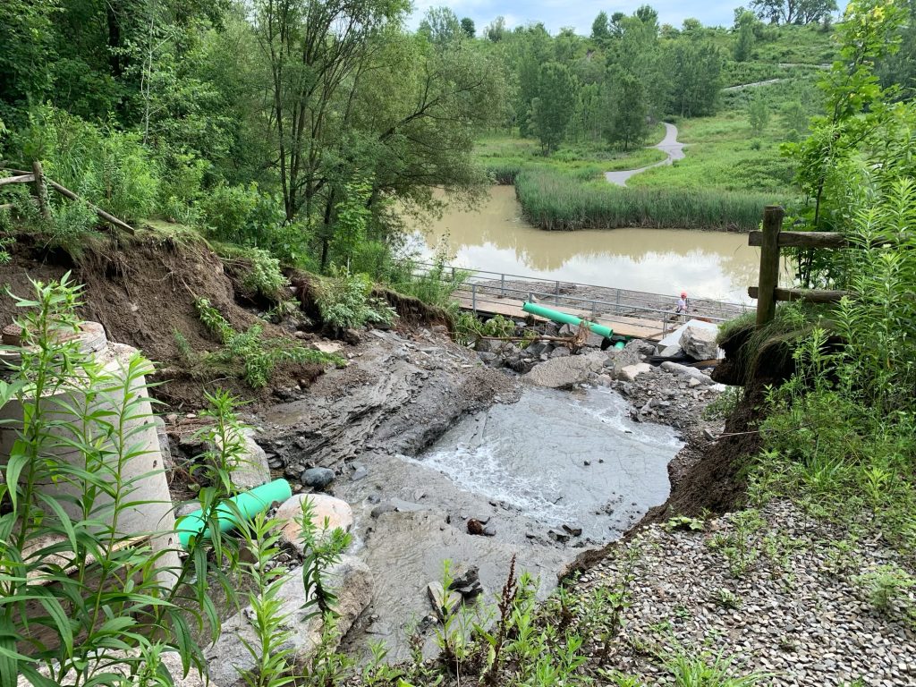
As a result of the storm event on July 16, 2024, the embankment that separates Mud Creek from the DVBW Park wetlands overtopped and breached, resulting in failure of the embankment, and permanent damage to the water inlet and cascade feature. Following emergency stabilization, a permanent fix will now be undertaken to restore the inlet.
Work is progressing well on Inlet reconstruction (Phase 1), despite challenging winter conditions. Construction completion for this portion of work is now estimated for end of March, at which time the Belt Line Trail will be re-opened.
Following completed re-construction of the Inlet (Phase 1), the Belt Line Trail will be re-opened for access and Phase 2 wetland enhancements will continue within Don Valley Brick Works Park. Phase 2 wetland enhancements in the park will result in localized trail closures within Don Valley Brick Works Park for culvert repairs and habitat enhancements. Alternative routes around work sites will remain available throughout this phase and Don Valley Brick Works Park will remain open. The Belt Line Trail and access to Evergreen Brick Works will remain open. Phase 2 works are anticipated to be complete by early June.
Work will begin on the permanent fix to the Mud Creek Inlet at DVBW Park. Work is anticipated to be complete February 2026.
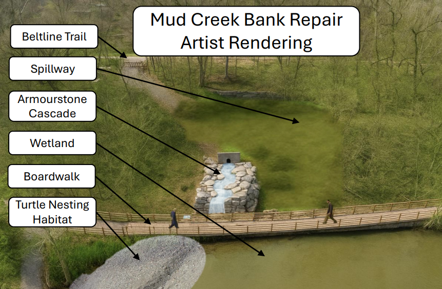
Work will include the repair of critical inlet infrastructure to restore stability to the Mud Creek channel and water flow between Mud Creek and DVBW ponds.
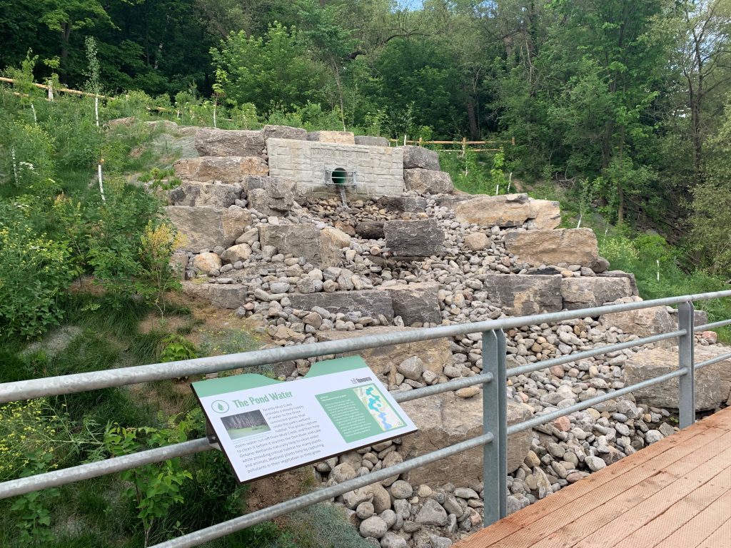
Emergency works have been completed to temporarily stabilize the embankment, and engineer inspections cleared the boardwalk as safe for public access.
The City, in cooperation with TRCA, have begun work to develop a resilient design solution to permanently restore function and stability to the site, ensuring the health of the wetlands. Implementation is scheduled for fall 2025.
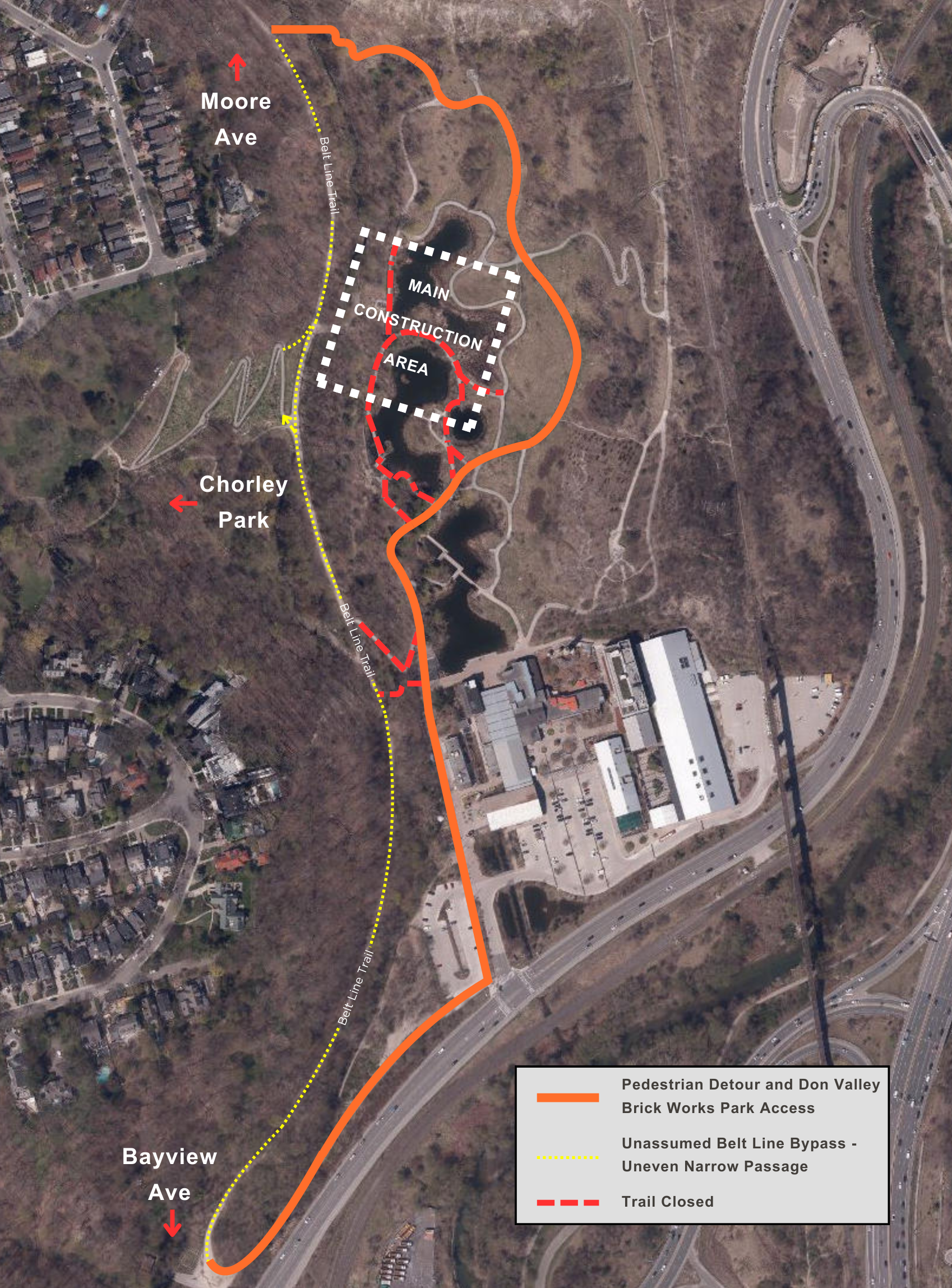
Construction access is required along the Belt Line Trail and within Don Valley Brick Works Park, and will impact both trail systems for the duration of the project (anticipated September 2025- February 2026):
Trail impacts and detours along the Belt Line Trail will be in effect during construction hours (7 a.m. – 4:30 p.m.). Fencing will be opened to users outside of construction hours (evenings, overnight, and weekends) along the Belt Line Trail, and Chorley Park Switchback.
Access to Don Valley Brick Works Park from the Belt Line Trail will remain limited to the north and south entrances for the duration of the project.
See map below for details.
Project information, and detour maps/signage will be installed on site.
As a result of the storm event on July 16, 2024, the embankment that separates Mud Creek from the DVBW wetlands overtopped and breached. This resulted in the ultimate failure of the embankment, significant erosion and permanent damage to the water inlet and associated cascade feature. In 2024, emergency works were undertaken to temporarily stabilize the embankment, and engineer inspections cleared the boardwalk as safe for public access.
Now, the City, in cooperation with TRCA, have developed a permanent and resilient design solution to restore function and stability to the site, ensuring the health of the wetlands. Construction will begin on this restoration project in September 2025. The work is anticipated to be complete February 2026.
Work will include the repair of critical inlet infrastructure to restore stability to the Mud Creek channel, and water flow between Mud Creek and DVBW ponds. The completed project will resemble the original inlet water cascade feature, with the addition of a robust spillway to protect slope stability during possible future flooding/overtopping events. Sediment management will also be undertaken to re-use or remove fine sediment wash-out from the original flooding event. Sediment reused on site will be targeted for turtle nesting habitat.
Following inlet repairs, future works will address additional wetland enhancements within DVBW, including culvert and habitat feature improvements. These works will be communicated in 2026.