Build Toronto has submitted a District Plan for the Allen District, which is located within the Downsview Area Secondary Plan area. The Allen District is generally located south of Sheppard Avenue West, on either side of Allen Road.
The Downsview Area Secondary Plan requires the completion of a District Plan to the satisfaction of the City prior to any development proceeding in a District. The purpose of the District Plan is to set out a finer grain level of detail for the development of the area. The District Plan is where streets and blocks are laid out with detailed information on land use, built form, massing and treatment of the public realm. It is also where a Public Art Strategy, Community Services and Facilities Strategy and Affordable Housing Strategy are refined to reflect a cohesive framework from which to draw from as development occurs. The District Plan is also important in setting out a Phasing Plan for the growth of the District.
Pursuant to the Downsview Area Secondary Plan, District Plans are required to be completed to the satisfaction of the City prior to any development proceeding.
January 13, 2015 – North York Community Council
A Preliminary Report dated December 15, 2014 was considered by North York Community Council on January 13, 2015. North York Community Council deferred decision until February 18, 2015.
February 18, 2015 – North York Community Council
The Preliminary Report was considered again by North York Community Council and deferred to its next meeting on April 14, 2015.
April 14, 2015 – North York Community Council
The Preliminary Report and a Supplementary Report (March 25, 2015) were adopted by North York Community Council and directed the following:
At its Pre-hearing Conference on June 29, 2011, the Ontario Municipal Board (OMB) issued an oral decision approving an updated Downsview Area Secondary Plan. A written decision from the Ontario Municipal Board was issued on August 17, 2011.
The vision for the Downsview Area Secondary Plan is to provide a land use and development framework that supports the significant public investment in rapid transit infrastructure and the National Urban Park, and achieves a mix of transit-supportive land uses of a high quality of urban design.
The Secondary Plan also sets out major goals that are reflected in specific policies. These goals speak to achieving connected parks and open spaces, a mix of land uses that are supportive of the existing and planned transit investments, connecting the Secondary Plan Area lands to the surrounding city, demonstrating a high quality of urban design and supporting sustainable development.
The Secondary Plan outlines minimum and maximum densities across the District as well as maximum heights. The Secondary Plan outlines seven districts that reflect different physical locations, characteristics and development expectations. The districts are the National Urban Park, Bombardier/DND/TTC, Stanley Greene, William Baker, Sheppard-Chesswood, Allen and Wilson. These districts encompass a variety of land uses, functions and each have specific goals and objectives.
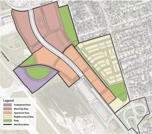
The Allen District is to develop as a mixed-use District with non-residential development near the Downsview Subway Station and residential development to the south. At-grade street connections across Allen Road will be established to connect and link the west and east sides of the District. Three local parks will be provided, one on the west side of Allen Road and two on the east side of Allen Road which will be linked by a greenway.