To develop a planning framework to guide future development for the Laird Focus Area that also includes the Mixed Use Areas along the west side of Laird Drive. The intent of the study is to refine and build upon the existing and recent planning initiatives undertaken in the area and develop a vision and planning framework for a complete community which supports both the Mixed Use Areas and Employment Areas designations within the study area. The planning framework, in conjunction with a public realm and open space framework, and built form plan, will be integrated with a multi-modal transportation system, a servicing strategy, and policies and/or strategic initiatives to serve the area.
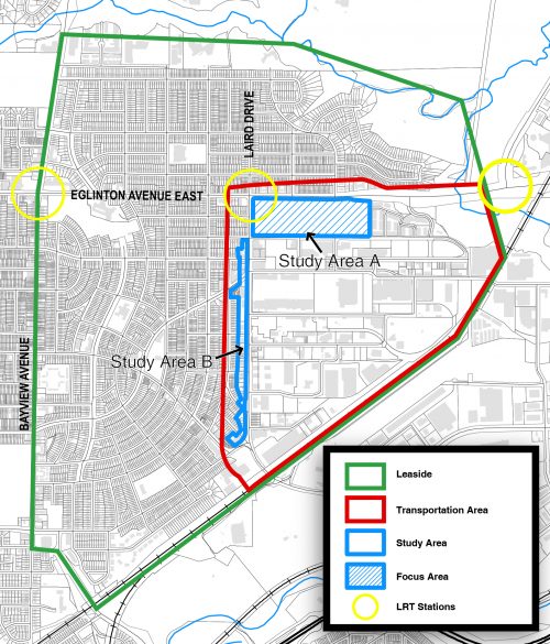
The Laird Focus Area, as identified in the Eglinton Connects Planning Study, consists of four large sites with large-format, low rise buildings and surface parking located on the southeast corner of Laird Drive and Eglinton Avenue East (Study Area A).
The properties designated Mixed Use Areas located on the west side of Laird Drive, between Vanderhoof Avenue south to Millwood Road, are smaller consisting of mostly commercial uses in 1-2 storey buildings (Study Area B). Together Study Areas A and B form the Laird in Focus Study Area.
The Laird in Focus Study will include a transportation review to support the future growth and development of the study area, and encompasses a larger geography that generally includes Laird Drive – Canadian Pacific Rail Tracks – Eglinton Avenue East.
Eglinton Avenue is identified as an intensification corridor in Metrolinx’s Regional Transportation Plan. The Eglinton Crosstown, which is a light rail transit (LRT) line that will run across Eglinton Avenue between Mount Dennis (Weston Road) and Kennedy Station is currently under construction and is anticipated to be in operation by 2021. From Keele station to Laird station the line will operate underground and will resurface onto Eglinton Avenue East just east of Brentcliffe Road. The intersection of Laird Drive and Eglinton Avenue East has been identified as a location for an LRT station. The main station entrance will be at the southwest corner of Laird Drive and Eglinton Avenue East and the secondary entrance will be located on the southeast corner.
The Eglinton Connects Planning Study identified the Laird Drive and Eglinton Avenue East area as one of six Focus Areas with larger parcels of land fronting Eglinton Avenue that could have a greater capacity to accommodate future population and employment growth. As part of the Eglinton Connects Planning Study, conceptual demonstration plans showing the potential arrangement of streets and blocks, building massing, and open spaces were created for each Focus Area. Policies were proposed that would guide the development of these Focus Areas, grouped under the themes of Travelling, Greening and Building similar to the study as a whole.
The vision and principles for three Focus Areas (Bayview, Dufferin, and West Side Mall) were advanced to a stage where a clear understanding of the appropriate planning directions had emerged. Substantial community consensus that the concept plans for these Focus Areas represented good planning was also achieved. Site and Area Specific Policies were proposed for these three Focus Areas to guide the future development of these Focus Areas by providing direction on appropriate building heights and massing, transportation connections, arrangement of open spaces, and the community services and facilities required to support development.
The remaining Focus Areas (Laird, Don Mills and The Golden Mile) along with mobility Hubs (Mount Dennis and Kennedy) were identified by the Eglinton Connects Planning Study as areas that required additional study and public consultation. The Laird Focus Area consists of four large sites with large-format, low rise buildings and surface parking located on the southeast corner of Laird Drive and Eglinton Avenue bounded by Eglinton Avenue East, Laird Drive, Vanderhoof Avenue and the western limit of Aerodrome Crescent (Study Area A).
The properties located on the west side of Laird Drive between Vanderhoof Avenue south to Millwood Road were not part of the Eglinton Connects Planning Study. These properties are designated as Mixed Use Areas and have been added as part of the study area for review (Study Area B). Study Area B includes more properties having smaller lot sizes in comparison to those within Study Area A, and is abutting stable residential Neighbourhoods to the west. For Study Area b, the Study will assess which properties potentially may be able to accommodate additional development and in particular taking into account transition to the residential Neighbourhoods to the west.