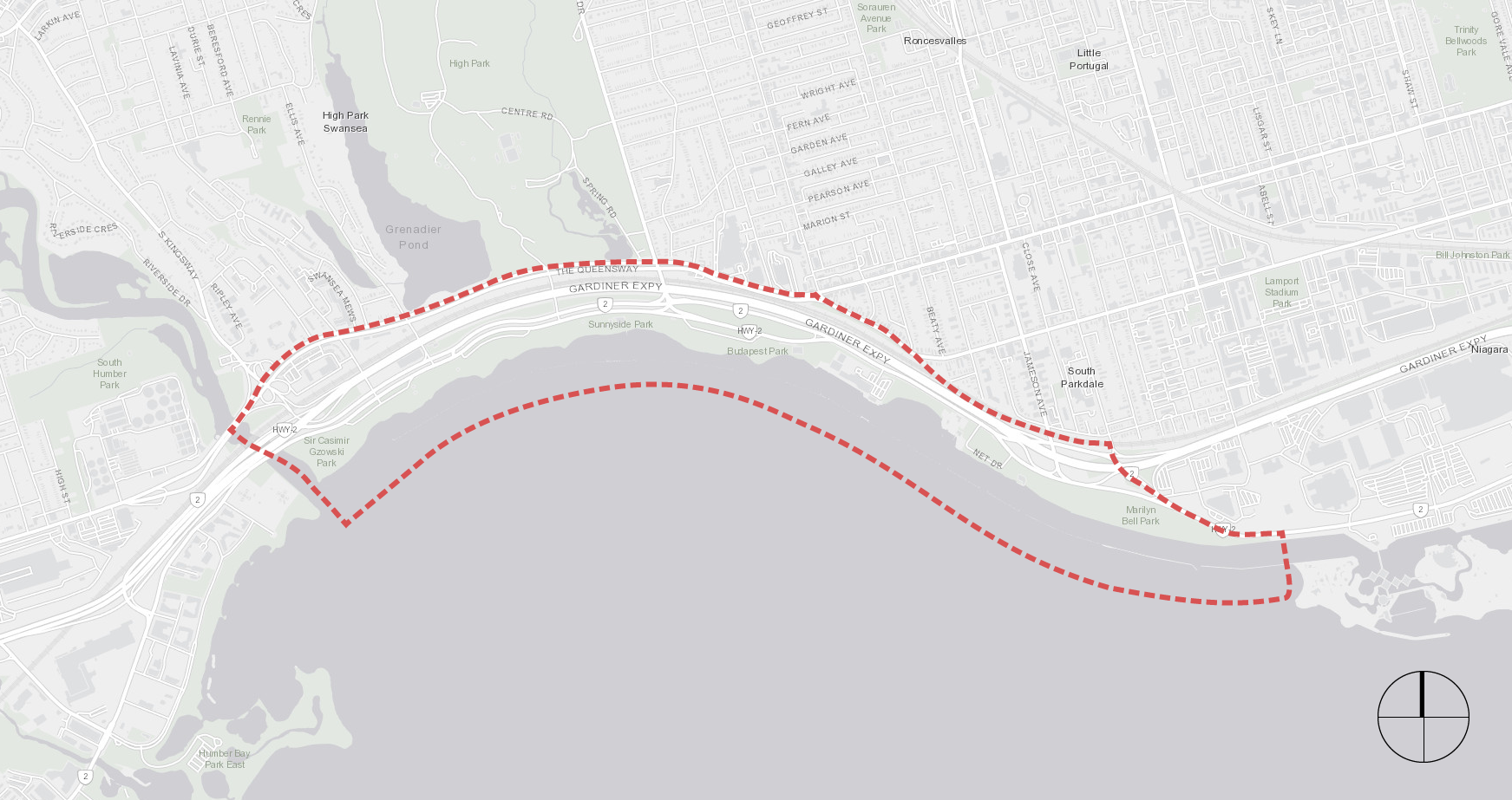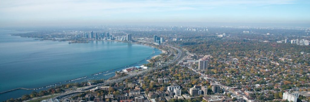
The City is developing the Western Beaches Public Realm Plan to update improvements to the Western Beaches over the next 20 years. The Western Beaches comprises a four-kilometre stretch of waterfront, parks and trails, and communities between the mouth of the Humber River and the eastern edge of Marilyn Bell Park. The Plan Update will provide a renewed vision for the Western Beaches, including recommendations and priorities for improvements, that reflects the changing conditions, current priorities and community needs since the Western Waterfront Master Plan was completed in 2009.
Join the in-person open house to learn about the final plan and ask questions of the project team.
Sign up for updates related to the Western Beaches Public Realm Plan Update or unsubscribe from the mailing list.
This project has been classified as an Involve project based on the International Association for Public Participation Spectrum. This means we work directly with the public, stakeholders and rightsholders throughout the Public Realm Plan update process to ensure that ideas and aspirations are understood and considered.
This project will have a Community Advisory Committee (CAC) with a mandate to provide a forum for feedback, guidance and advice to the project team at key decision points during the community engagement process. The CAC will meet once during phase 1 and phase 2 of the community engagement process. The CAC is not a decision-making body and does not speak on behalf of the entire community.
This project will have an Indigenous Advisory Circle consisting of Indigenous leaders, knowledge keepers, community advocates and design professionals to establish meaningful dialogue and provide cultural insights throughout all engagement phases on Indigenous Placekeeping for the Western Beaches.
In the summer and fall of 2023 a Public Life Study mapped five zones in Western Beaches to gather data on park users’ demographics and activities, assess amenity provisions, and observe conflict areas between motorists, cyclists, and pedestrians to improve usability and safety.
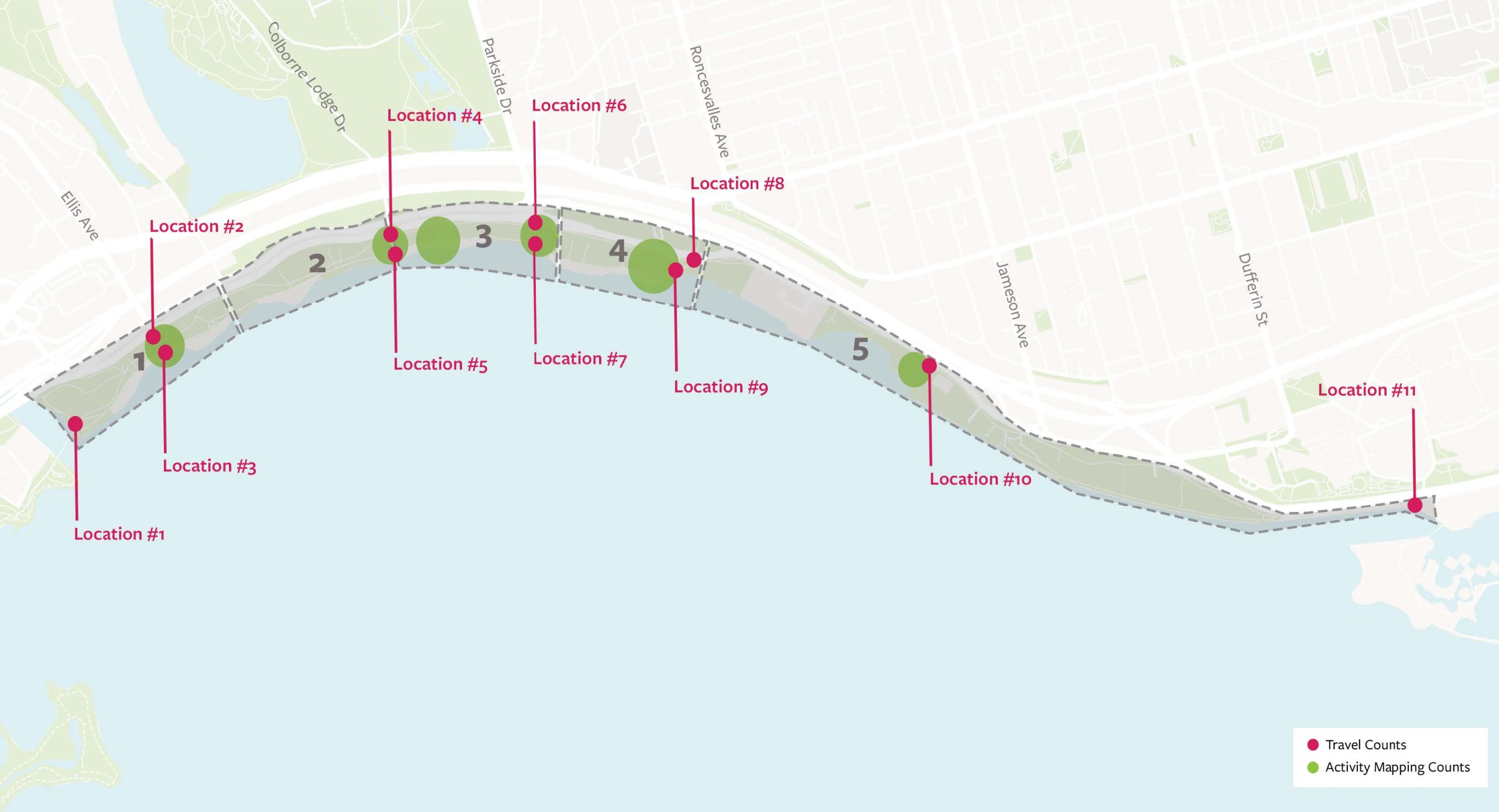
The study found underrepresentation of children, teenagers, and older adults, with male users being the majority among cyclists and in the evening. Summer attracts more visitors from other areas of the city whereas fall sees more local residents. Over 80% of visitors have positive responses to the Western Beaches, valuing water access, and suggesting improvements such as additional food/drink vendors, better water quality, and enhanced lighting.
The study highlights opportunities to enhance safety, improve maintenance and amenities, and encourage year-round engagement with the Western Beaches through better trail delineation, safer intersection crossings, and an all-season public space design program.
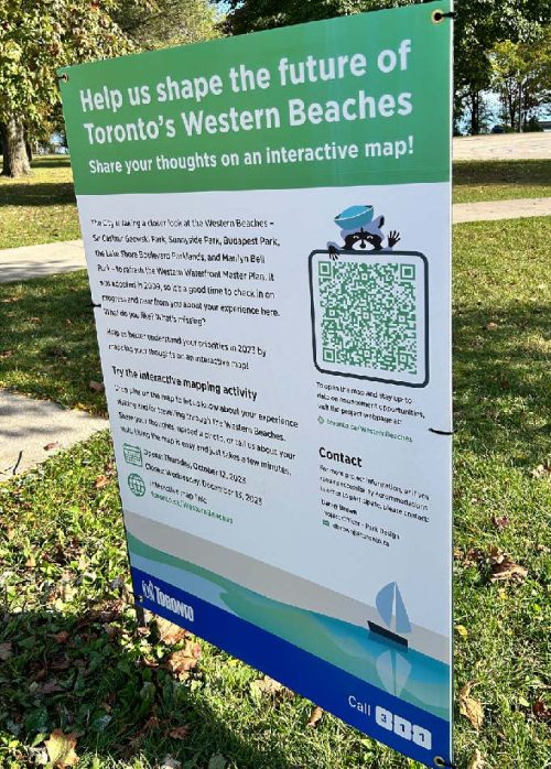
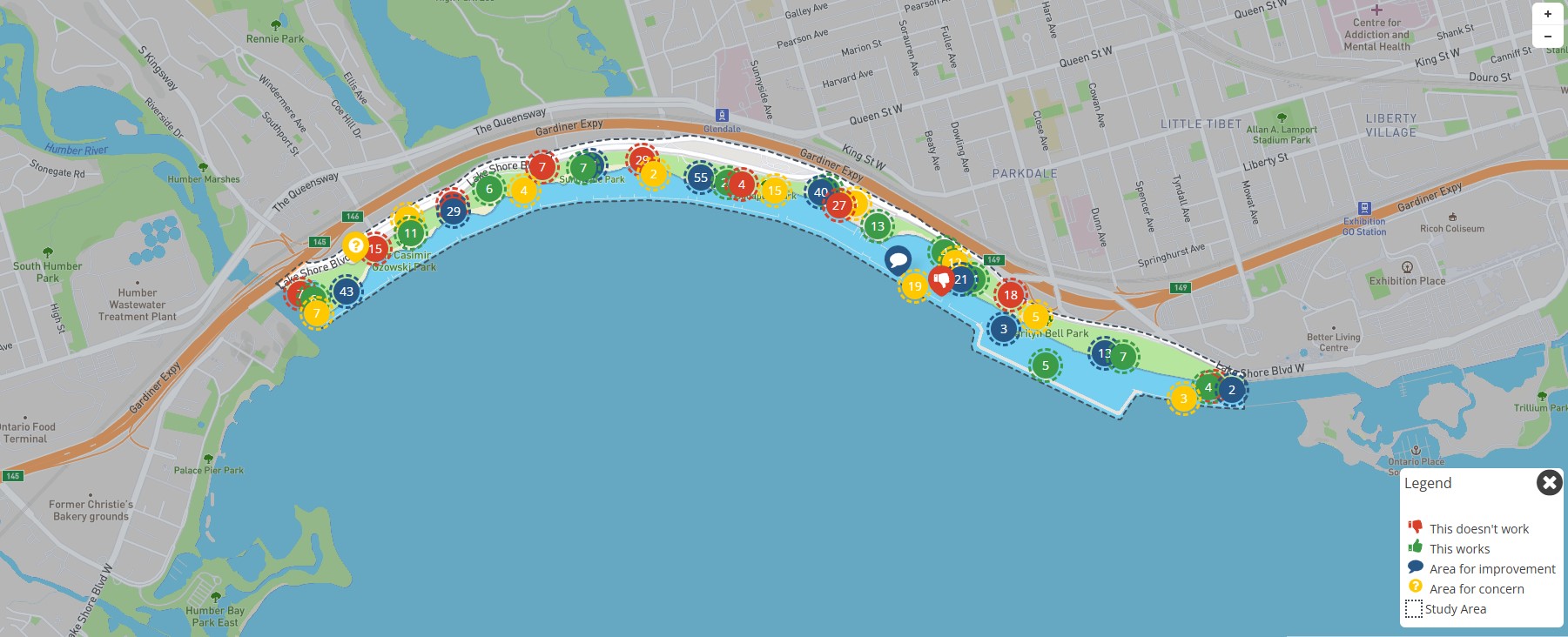
Between October 12th to December 13th, 2023, an interactive mapping exercise gathered approximately 1,300 comments from around 1,500 unique users, fostering lively discussions about the Western Beaches study area.
Participants shared their experiences on this online forum on how they travel and use the Western Beaches area. They also identified various areas of concern and improvement, highlighting priorities for further exploration and discussion. There was strong consensus on enhancing user safety and comfort along the Martin Goodman Trail and emphasizing the importance and diversity of community uses along the western waterfront. The image below shows the commenting platform highlighting areas of concerns and areas for improvements in Western Beaches.
In this phase, the City worked with the community, the Community Advisory Committee and the Indigenous Advisory Circle to review and update the vision, guiding principles and big moves for the Western Beaches Public Realm Plan. The outcomes informed the development of draft recommendations in Community Engagement Phase 2.
The vision is created with the community to describe the ideal future Western Beaches area. It is a big-picture statement that should inspire everyone toward a common understanding of the project’s overall goals and objectives. The draft vision statement is:
Western Beaches will be many things at once – offering a multitude of experiences to all users. It will continue to be a beloved and versatile stretch of Toronto’s western shoreline, with a series of parks, paths, and beaches that invite people to linger, play, reflect and move through. Movement will feel seamless and intuitive, supported by meaningful connections and a strong sense of place. It will be a vibrant and welcoming destination to everyone, animated by places to sit, gather and reflect. More than just a view, it will offer a true waterfront experience, where people can see, touch and feel the water.
The guiding principles are high-level directions that reflect the community’s most important values and ideas for how Western Beaches should look and feel. There are also several key technical considerations such as flood and erosion mitigation, climate change, and transportation-related goals that inform and need to be reflected in these principles. They help to clarify the vision statement and guide how the area should be planned for by describing the desired outcomes. The draft guiding principles are:
On July 6, the design team held a pop-up event in Sunnyside Park (immediately west of Sunnyside Pavilion) and Budapest Park (immediately west of Palais Royale). On July 15, the design team held a pop-up event in Sir Casimir Gzowski Park (near the playground and picnic shelter) and Marilyn Bell Park (near the tennis courts and outdoor fitness equipment). These events shared and collected feedback on the emerging vision, guiding principles and precedent images for the Western Beaches Public Realm Plan Update.
From July 11 to July 27, an online survey collected feedback to help shape the emerging vision, guiding principles and priorities for the Western Beaches. The survey was promoted through on-site signage, this page, email and social media and digital ads. The survey received 1,448 responses.
Respondents were asked how satisfied they were with the vision statement
62 per cent of respondents suggested changes to the vision statement. Respondents wanted more attention in the vision statement to the following areas. Ideas are organized from most to least common:
The 14 guiding principles were shared with survey respondents. When asked to rank their top five most important guiding principles from most to least important, the results based on weighted ranking were as follows:
283 respondents (28 per cent) suggested changes or additions to the guiding principles. The key themes suggested that the guiding principles better address the following areas. Themes are listed from most to least common:
Participants were asked to select which of 12 interventions they thought would help achieve the vision and guiding principles for the Western Beaches Public Realm Plan Update. The ranked responses are as follows:
409 respondents (41 per cent) provided suggestions for additional big moves. The common themes of this feedback from most to least common include:
On July 3, the project team met with the Community Advisory Committee for the second time. The meeting introduced members to draft vision and guiding principles, provided opportunities for interactive feedback, and hosted breakout workshops on identity, mobility, recreation and natural systems.
Download the July 3, 2025 Community Advisory Committee meeting summary.
On June 26, the project team met with the Community Advisory Committee for the first time to discuss the project, answer questions and establish terms of reference.
Download the June 26, 2025 Community Advisory Committee meeting summary.
In this phase, the City and its design consultants worked from the outcomes of Community Engagement Phase 1 and technical considerations to develop design options for the Western Beaches Public Realm Plan Update. These plan options were presented to the community for feedback and will be used to develop the final Western Beaches Public Realm Plan Update.
Western Beaches will be many things at once – offering a multitude of experiences on land and water, welcoming all users in every season.
It will continue to be a beloved and adaptable stretch of Toronto’s western shoreline, safe and easy to get to, with a series of parks, paths, naturalized areas, beaches, and waterways that invite people to linger, play, reflect and move through.
Movement will feel easy and intuitive, comfortable for all modes of active transportation, supported by meaningful connections, universal accessibility, and a strong sense of place. It will be a vibrant and welcoming destination for everyone, animated by spaces for quiet reflection, lively gathering and active recreation.
More than just a view, it will offer a true waterfront experience, where people can see, touch, and feel the water, and enjoy clean, swimmable shores alongside inclusive opportunities for water-based recreation.
Grounded in Indigenous ways of knowing, it will honour deep relationships with the land and water, celebrate Indigenous presence, and reflect the Western Beaches’ place within a larger living system, connected to the lake, river, and surrounding watershed where people, nature and place are deeply intertwined.
Above all, it will be a sustainable, and resilient landscape where all lives, species and future generations thrive.
From November 20 to December 8, an online survey collected feedback to help shape the emerging big moves and draft ideas for the Western Beaches Public Realm Plan Update. The survey was promoted through on-site signage, Councillor updates, this page, email and social media and digital ads. The survey received 792 responses.
Respondents were asked how much they agreed or disagreed with each of the 14 big moves. All big moves received at least 49 per cent support. The top five big moves that received over 74 per cent support are listed below:
267 respondents provided additional comments. The most common comments are summarized below:
Respondents were asked to share their support for the following ideas under the 14 big moves and provide any additional comments.
69 respondents provided additional comments:
69 respondents provided additional comments:
101 respondents provided additional comments:
60 respondents provided additional comments:
180 respondents provided additional comments:
69 respondents provided additional comments:
24 respondents provided additional comments:
90 respondents provided additional comments:
92 respondents provided additional comments:
59 respondents provided additional comments:
38 respondents provided additional comments:
33 respondents provided additional comments:
37 respondents provided additional comments:
17 respondents provided additional comments:
On November 27, participants attended a virtual public meeting to learn about and provide feedback on the draft ideas for the Western Beaches Public Realm Plan Update. The meeting was promoted through on-site signage, Councillor updates, this page, email and social media and digital ads.
Download the November 27, 2025 virtual public meeting presentation.
On November 19, the project team met with the Community Advisory Committee for the third time. The meeting introduced the revised draft vision and guiding principles and provided an opportunity for members to review, discuss and provide input on emerging draft ideas as recommendations for the Western Beaches Public Realm Plan.
Download the November 19, 2025 Community Advisory Committee meeting summary.
In this phase, the City will share the final Western Beaches Public Realm Plan Update at a final Open House event. It will also be posted on this webpage and shared with the subscribers on the project mailing list. The project will then move on to develop the final implementation and costing strategy.
The anticipated outcome of this phase is the final Western Beaches Public Realm Plan Update.
The community engagement events anticipated in this phase include:
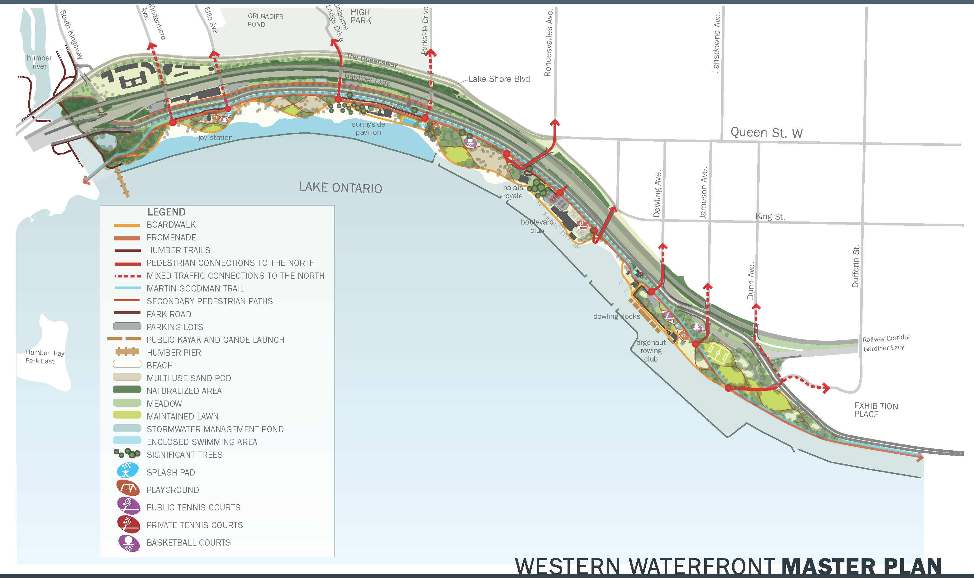
The Western Waterfront Master Plan (WWMP) was approved by City Council in 2009. Its purpose was to provide a vision for the Western Waterfront and guide future decisions regarding improvements to the public realm. The plan aimed to shape the development and transformation of the Western Waterfront over the next few decades. It has proposed several large initiatives such as north-south pedestrian and cyclist crossings, enhancements to the Martin Goodman Trail, expanded beaches with improved water quality, and increased opportunities for water-based recreation.
The context of the Western Beaches has changed since 2009. Developments such as rising lake levels, shoreline erosion, an aging break water, the COVID-19 pandemic, the adoption of the Reconciliation Action Plan, and increased awareness of the historical and cultural significance of the mouth of the Humber River has resulted in the need for an updated plan.
The update to the 2009 Plan will share progress made to date, list current initiatives, reconfirm project objectives, refresh priority actions, and identify new opportunities for improvements to the parks, trails, roads, and other facilities that support the Western Beaches and its visitor experience.
The goals of Western Beaches Public Realm Plan Update are to create a trajectory for the Western Beaches as:
The Western Beaches spans over four kilometres and covers an area of 120 hectares in Toronto’s western waterfront. It extends east from the mouth of the Humber River to the eastern edge of Marilyn Bell Park. Its northern boundary follows the historic shoreline along the CN Rail Corridor embankment and The Queensway, while its southern boundary extends into Lake Ontario to include the existing breakwaters.