The City is studying the area around Glencairn Subway Station and Marlee Avenue to guide growth, align with provincial density requirements around transit stations, and provide for a resilient and inclusive complete community. Please see below to learn more about the Growing Marlee-Glencairn study and how you can get involved.
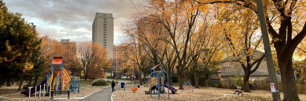
Glencairn Subway Station is located along the Yonge-University subway line in North York. It opened in 1978 and is currently one of the least-used subway stations in the city. The area is currently experiencing a high level of development interest, particularly for the area west of Allen Road and along Marlee Avenue where the City has received development applications for multiple-unit, mid-rise and high-rise mixed-use buildings.
Both provincial and city policy frameworks focus growth on areas served by transit to optimize the use of existing infrastructure and support transit investment. In accordance with the Provincial Planning Statement, the City must identify the boundaries of the Glencairn Major Transit Station Area (approximately 500-800 metres surrounding the station) and plan for a minimum density target of 200 people and jobs per hectare. The City can further identify the area as a Protected Major Transit Station Area, which enables the City to apply inclusionary zoning for affordable housing units. Both Major Transit Station Areas and Protected Major Transit Station Areas are subject to approval by the provincial Minister of Municipal Affairs and Housing.
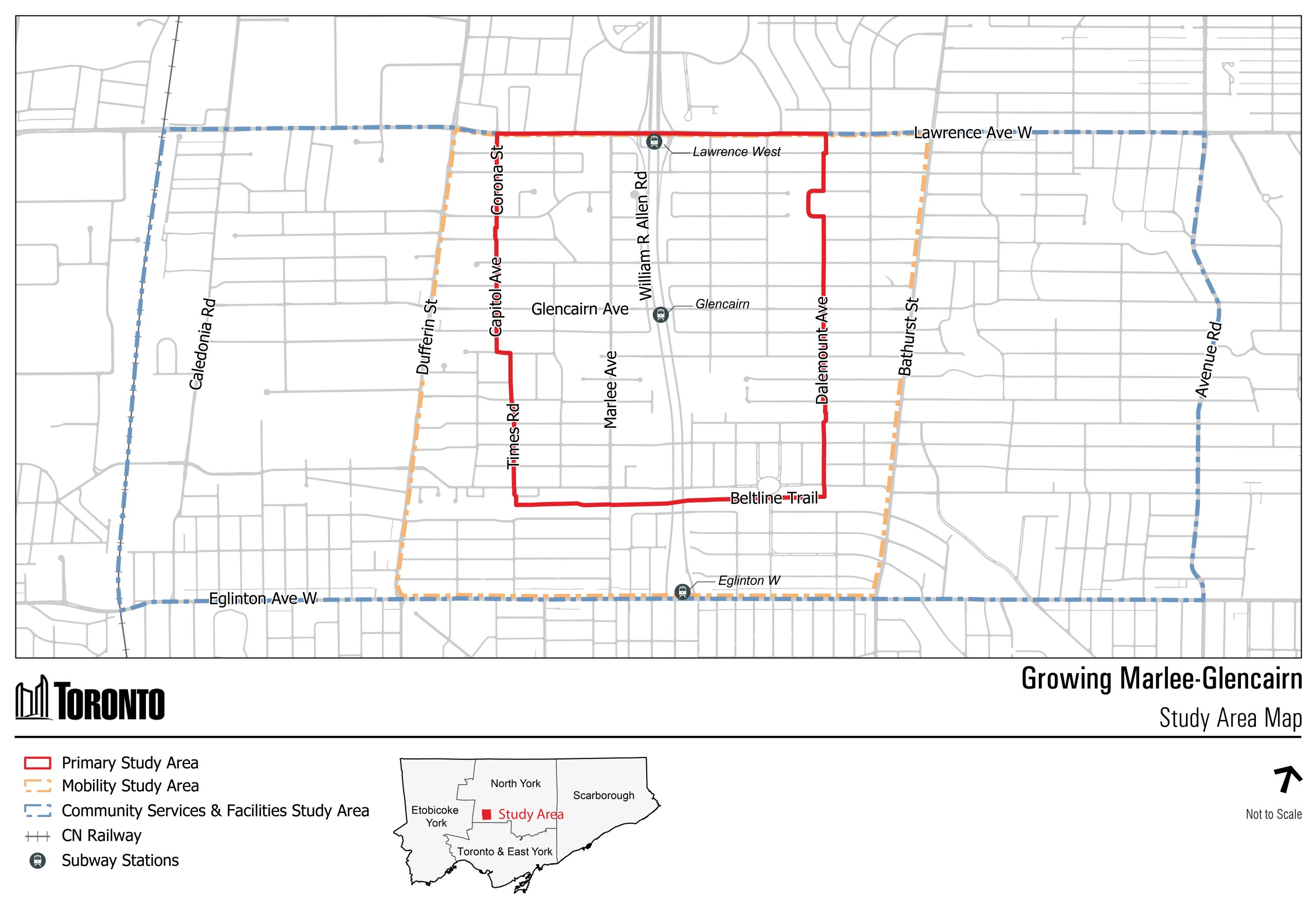
The primary study area for Growing Marlee-Glencairn is located generally within 800 metres of Glencairn Subway Station, south of Lawrence Avenue West, west of Bathurst Street, north of Eglinton Avenue West and east of Dufferin Street (see map below). Larger study areas are being used for mobility, parks and open space, community services and facilities, servicing and stormwater management.
Growing Marlee-Glencairn includes the following integrated components:
Growing Marlee-Glencairn is a two-year study, which will be informed by meaningful and inclusive engagement throughout all three phases:
Phase 1: Background Analysis and Visioning – Gather and review existing information on the Study Area, assess current conditions, and develop an emerging vision and guiding principles (Fall 2024 to Winter 2025)
Phase 2: Options Analysis – Develop and assess options and identify a preferred option for guiding growth (Spring to Fall 2025)
Phase 3: Final Report and Implementation Strategy – Finalize the preferred option and identify a path to implement potential policy changes and initiatives (Winter to Spring 2026)
All proposed time frames are approximate and subject to change.
Item 2025.NY23.7: On May 21 and 22, 2025, City Council adopted the Emerging Vision and Guiding Principles to be used as the basis for further technical work and community engagement, among other decisions.
Item 2022.PH35.16: On July 19, 2022, City Council adopted four Official Plan Amendments for 115 Major Transit Station Areas/Protected Major Transit Station Areas across the City as part of its municipal comprehensive review and conformity to the Growth Plan for the Greater Golden Horseshoe, 2020. The City Council report identifies Glencairn as one of four potential Major Transit Station Areas/Protected Major Transit Station Areas requiring a local planning study to assess planning opportunities and meet the minimum planned density target of 200 people and jobs per hectare.
Item 2022.NY33.25: On June 28, 2022, North York Community Council directed staff to engage a consultant team to undertake a study for Glencairn station to establish a planning framework to achieve (or exceed where appropriate) the Major Transit Station Area density target in support of the City’s municipal comprehensive review and contribute to the creation of a sustainable and complete community.
Item 2022.IE27.14: On February 2 and 3, 2022, City Council directed staff to report back on traffic and transportation improvements in the Marlee Avenue corridor, including access ramps to Allen Road, which will be incorporated into this study.
Please visit the City’s Application Information Centre for details and up-to-date information on development applications in the Study Area.
Please visit the City’s Building Permit Application & Inspection Status Centre for information on building permits in the Study Area.
See Get Involved for upcoming engagement events as part of Phase 3 of the Study.
The City hosted a Public Open House on Thursday, April 30, 2026, at 70 Ridge Hill Drive (School gymnasium), to present an emerging plan for the Marlee-Glencairn area as part of Phase 3 of the Growing Marlee-Glencairn Study.
At the open house, community members learned about and shared feedback on:
The City hosted three pop-up events in the local community to spread word about the emerging options part of Phase 2, answer questions about the study, and invite community members to participate and share input.
On December 10, 2025, staff held the second Urban Indigenous Focus Group at North Toronto Memorial Community Centre. Participants heard about the progress on the Growing Marlee-Glencairn Study and shared feedback on key topic areas including:
On July 16, 2025, staff held an Urban Indigenous Focus Group at North Toronto Memorial Community Centre to get feedback on key topic areas of:
City of Toronto staff hosted a series of pop-up events in the local community as part of the Growing Marlee-Glencairn study. These events were an opportunity for residents to ask questions, share feedback, and learn more about the planning process.
You can sign up for e-updates below and/or share your feedback and questions at any time with the project team at GrowingGlencairn@toronto.ca.
The City hosted two pop-events to spread the word about the Study and invite community members to participate and share their input
The Community Advisory Circle was established to provide community and business/organization perspectives, insights and information to help shape the Study. The Community Advisory Circle is a group of 21 members, selected through a civic lottery process to ensure local diversity is reflected.
The City hosted an in-person Community Design Workshop on December 4, 2024 at John Polanyi Collegiate Institute, for participants to learn about the study and share their vision, ideas and priorities for the future of the area.
The City hosted a workshop with developers in the community to understand their perspectives on opportunities and challenges within the Study Are and inform development of the Emerging Vision and Guiding Principles on January 14, 2025 at North York Civic Centre.
See Growing Glencairn: Phase 1 What We Heard Report for more information on the Phase One engagement. Contact GrowingGlencairn@toronto.ca for any previous meeting materials.
You can sign up for e-updates below and/or share your feedback and questions at any time with the project team at GrowingGlencairn@toronto.ca.
City Planning collects your personal information under the legal authority of the Planning Act, section 17(15) and Toronto City Council Item 2023.MM13.32, as confirmed by the City of Toronto By-law 1332-2023. The information will be used for the purpose of providing updates about the progress of the Growing Glencairn study. Questions about this collection can be directed to the Project Manager, Strategic Initiatives, City Planning, Metro Hall, 55 John Street, 22nd Floor, Toronto, Ontario, M5V 3C6 or by telephone at 416-392-4524.