On April 21, 2022, City Council adopted a motion to undertake a study of the Upper Jarvis area, to evaluate the implications of current development applications on lands designated as Neighbourhoods and Apartment Neighbourhoods within the area and develop a planning framework, as appropriate, to assist in evaluating future development proposals.
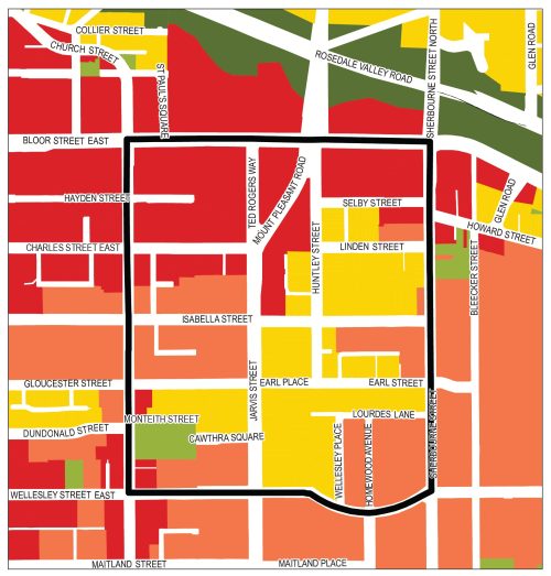
The Upper Jarvis Neighbourhoods Study boundary is Bloor Street East to the north, Sherbourne Street to the east, Wellesley Street to the south and Church Street to the west. The study will focus on lands designated as Neighbourhoods and Apartment Neighbourhoods in the City of Toronto Official Plan.
While we aim to provide fully accessible content, there is no text alternative available for some of the content on this site. If you require alternate formats or need assistance understanding our maps, drawings, or any other content, please contact Jeremy Humphrey, Senior Planner, at 416-392-1729.
This study is being conducted in Ward 13 Toronto Centre.
In 2021 and 2022, the City of Toronto received several development applications for the Upper Jarvis Area to re-designate Neighbourhoods-designated lands to Apartment Neighbourhoods and Mixed-use Areas to permit the development of tall buildings in this area.
The Neighbourhoods designation in the Official Plan consists of areas that are considered physically stable, made up of residential uses in lower scale buildings such as detached houses, semi-detached houses, duplexes, triplexes and townhouses, as well as interspersed walk-up apartments that are no higher than four storeys. Parks, low scale local institutions, home occupations, cultural and recreational facilities, small-scale retail, service and office uses are also provided for in Neighbourhoods.
Development in Neighborhoods-designated lands is expected to respect and reinforce the existing physical character of each geographic neighbourhood. Official Plan amendments are required to permit the construction of tall buildings in Neighbourhoods-designated lands.
On April 21, 2022, Council adopted a motion to undertake a study of the Upper Jarvis Area to evaluate the implications of current development applications in the study area and to develop a framework, as appropriate, to help evaluate future applications in the area. The direction can be found in 47-65 Huntley Street, 2-18, 24, and 26 Linden Street, and 1-11 Selby Street – Official Plan and Zoning Bylaw Amendment and Rental Housing Demolition Applications – Preliminary Report.
Members of the public and other stakeholders are invited to participate in the Upper Jarvis Vision & Area Character Survey. This survey will be used to inform the Upper Jarvis Planning Framework and will be active until March 28, 2023.
Survey answers may also be submitted by email or phone to the contact listed in the contact information section.
The City hosted a virtual community consultation meeting on March 1, 2023 for residents to learn about the Upper Jarvis Neighbourhoods Study and to communicate what is valued about Neighbourhoods and Apartment Neighbourhood-designated lands in the Upper Jarvis Area and what changes may be desirable.
The meeting included a presentation, a Question & Answer session, a discussion of the physical elements that define the Upper Jarvis Area and priorities for its future.
Information and reports will be posted as they become available.