Davenport Road and Macpherson Avenue Safety Improvements
Toronto and East York Community Council deferred consideration of the item until April 1. View the staff report at Item - 2026.TE29.40. The Public Consultation report is available under the Public Consultation tab below.
The City of Toronto is proposing safety improvements at several intersections and locations along Davenport Road, Cottingham Road, Poplar Plains Road and Macpherson Avenue.
The plan aims to enhance safety and accessibility for all road users including pedestrians and people who cycle or drive, and to build new pedestrian and cycling connections in the neighbourhood. These improvements support the City’s Vision Zero Road Safety Plan, Complete Streets Guidelines, and the TransformTO Net Zero Climate Action Strategy.
Roadway improvements would be completed as part of planned road resurfacing in the neighbourhood in 2027.
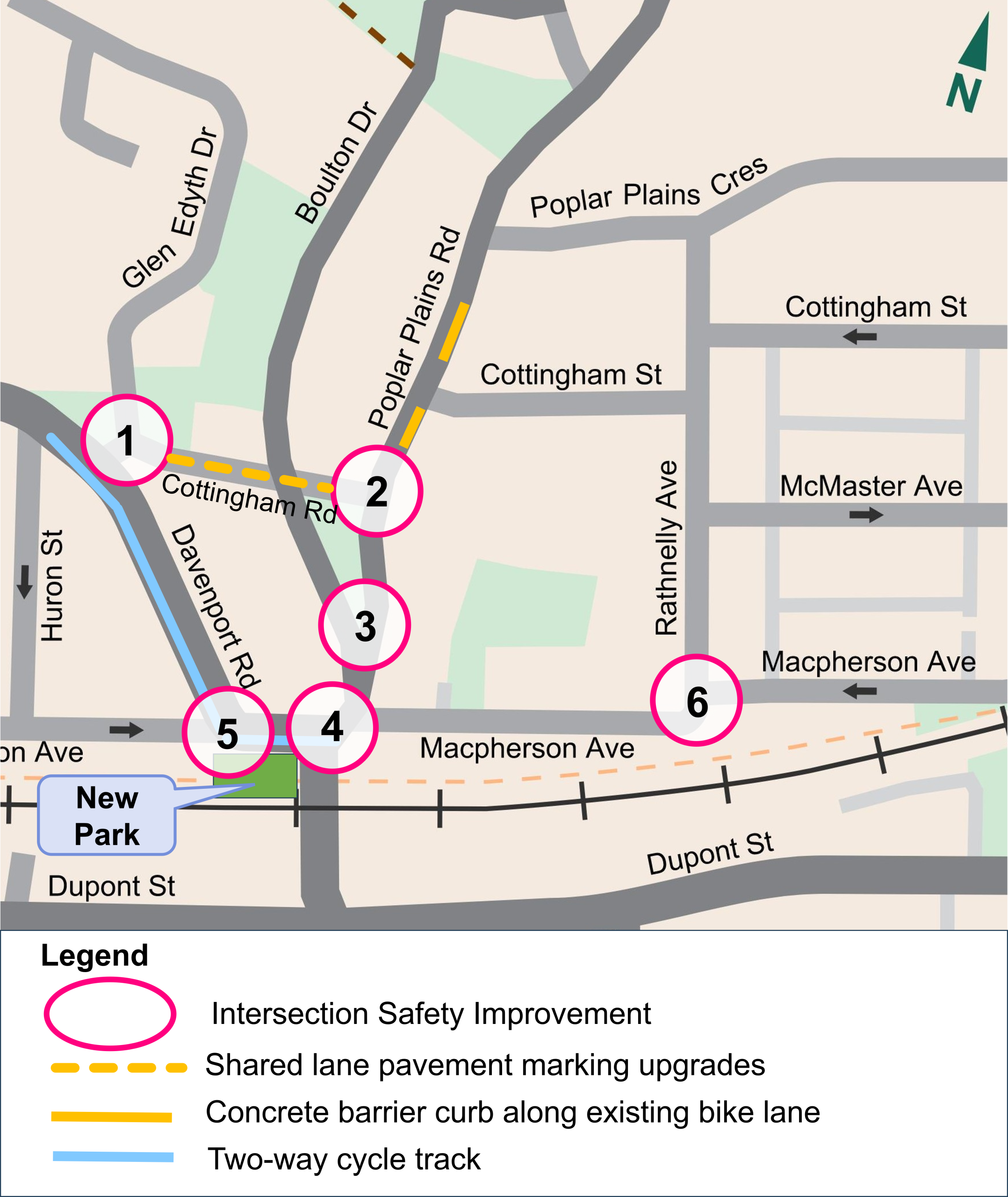
Project Area
The project area is along Davenport Road and Macpherson Avenue from Huron Street on the west to Rathnelly Avenue on the east, and along Cottingham Road and Poplar Plains Road to the north.
Map of project area
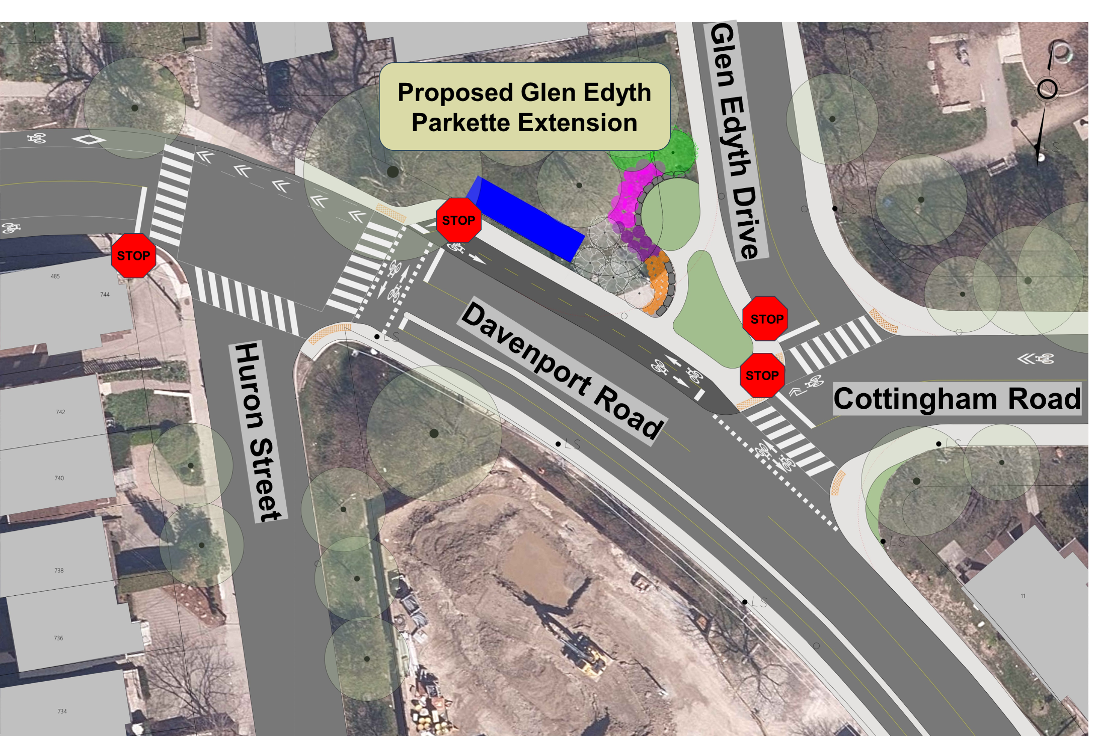
Cottingham Road at Glen Edyth Drive and Davenport Road
Cottingham Road at Poplar Plains Road
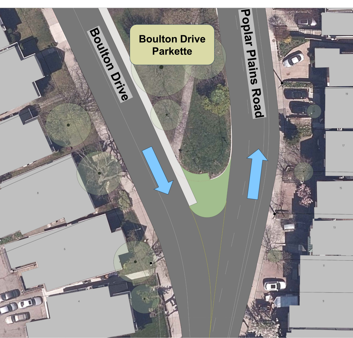
Boulton Drive at Poplar Plains Road triangle
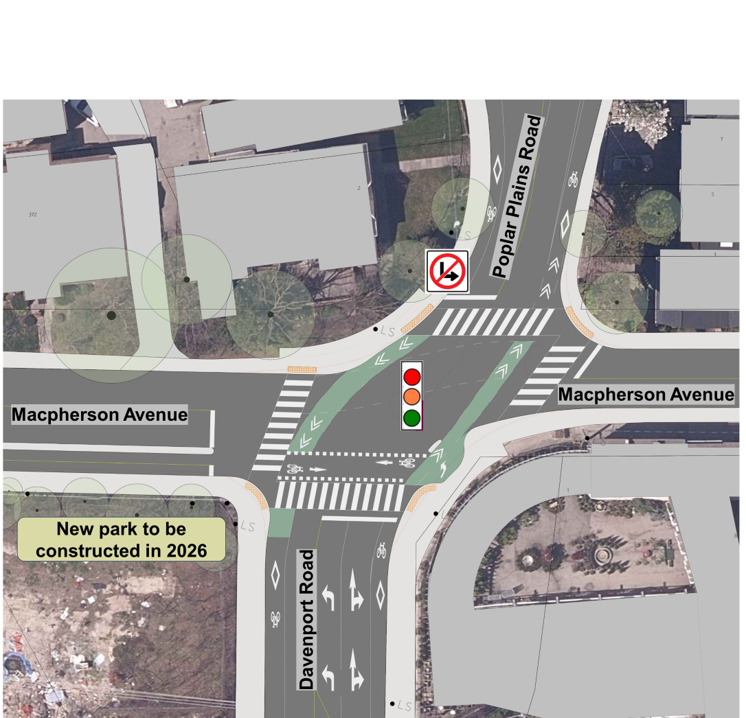
Davenport Road / Poplar Plains Road at Macpherson Avenue
Macpherson Avenue at Davenport Road
Macpherson Avenue at Rathnelly Avenue
Background
The project is being advanced now for several reasons.
Between 2015 and 2018, residents and residents’ groups worked with the local Councillor’s office to pursue safety improvements at four intersections in the project area through the City’s Transportation Safety and Local Improvements program. The City prepared preliminary designs and installed some improvements using quick-build materials.
In 2021 design was completed for a new park south of Macpherson Avenue at Davenport Road that will be constructed in 2026 and require new connections to the park for pedestrians and people cycling.
In 2027, road resurfacing is planned along various streets in this area which provides an opportunity to make more complete and permanent safety improvements in the greater area.
The proposed changes would improve safety for all road users by:
Reducing dangerous vehicle movements and providing safe and clear direction through intersections
Improving and providing new safe connections for people walking and cycling
Changes will also incorporate improvements to public space.
Proposed Changes on Cottingham Road and Davenport Road
Davenport Road Cycle Track between Huron Street and Poplar Plains Road
The proposed design changes the existing one-way painted bike lanes to a single two-way cycle track on the south side of Davenport Road/Macpherson Avenue . The change includes:
A protective concrete curb to separate people cycling from people driving.
No impacts to parking or vehicle movement.
Opportunity for westward extension of the two-way cycle track along Davenport Road in the future.
Cottingham Road at Glen Edyth Drive and Davenport Road
The proposed design creates a more typical intersection with clear direction for vehicles and a reduced pedestrian crossing distance. The proposal includes:
New intersection design with two separate intersections.
Cottingham Road and Davenport Road: Extending Cottingham Road to create a normalized three-way intersection with reduced curb radii, narrowed and marked pedestrian crossing and cycle crossride across Cottingham Road.
Glen Edyth Drive and Cottingham Road: Expansion of Glen Edyth Drive Parkette with the extension of Glen Edyth Drive by approximately 13.5 metres ending at Cottingham Road.
Upgraded shared lane markings on Cottingham Road.
The design includes new safe connections from the proposed two-way cycle track on Davenport Road to existing bike lanes.
People cycling between the Davenport two-way cycle track and shared lanes on Cottingham Road would use a raised cycle track along the parkette edge and new crossrides across Cottingham and Davenport at Huron to make the connection safety.
People cycling westwards along the two-way cycle track would use the crossride across Davenport Road at Huron Street and proceed westwards on the one-way bike lane on the north side of Davenport.
Improved street lighting.
No impacts to parking or existing trees.
Cottingham Road at Davenport Road and Glen Edyth Drive
Proposed Glen Edyth Drive Parkette Extension
The proposed extension of Glen Edyth Drive Parkette would include planting, a concrete pathway, sod areas and armourstone seating walls. A new sidewalk and raised two-way cycle track run along the south of the parkette.
Additional design details and images appear in the public consultation materials.
Proposed Changes on Poplar Plains Road
Cottingham Road at Poplar Plains Road
The proposed design provides clearer direction for people driving and new safe crossings for people cycling. The proposal includes:
Curb radii reductions with narrowed and clearly marked crossings to improve pedestrian safety.
Designated and marked vehicle left-turn lane and through lane on Poplar Plains south of Cottingham Road.
Concrete barrier curbs at the intersection and in locations north along Poplar Plains Road to provide physical protection for people cycling.
A two-stage crossing queue box provides a dedicated space for people cycling while waiting to turn left onto Cottingham Road.
Refreshed paint marking to indicate shared lane use on Cottingham Road.
No impacts to parking or existing trees.
Boulton Drive at Poplar Plains Road triangle
The proposed design reduces the turn radius at this corner to restrict unsafe vehicle maneuvers. The proposal includes:
Extension of Boulton Drive Parkette to the south with sod area.
Sidewalk extension to the south.
No impacts to parking or existing trees.
The corner radius reduction will:
Restrict illegal U-turns from Poplar Plains Road to Boulton Drive while protecting legal U-turns from Boulton Drive to Poplar Plains Road.
Encourage vehicles to travel and turn at appropriate speeds.
Boulton Drive at Poplar Plains Road Triangle
Additional design details and images appear in the public consultation materials.
Proposed Changes on Macpherson Avenue
Macpherson Avenue at Davenport Road and Poplar Plains Road
The proposed design reconfigures the skewed intersection into a normalized four-leg intersection. Proposed changes create clear direction for people driving and new safe connections for pedestrians and people cycling. The proposal includes:
A new traffic signal and removal of roadway medians and barriers.
Improved road alignment on the south side of the intersection, supported by a two-way cycle track west of Davenport Road / Poplar Plains Road.
Westbound through movement would be permitted for vehicles along Macpherson in the new design.
Curb radii reductions and narrowed, clearly marked pedestrian crossings at all legs of the intersection.
Accessibility upgrades for people with low to no vision at all corners, including tactile walking surface indicators.
Marked crossing areas for people cycling.
No change to prohibited southbound left turn movement from Poplar Plains Road.
Expanded sidewalk for a safe pedestrian waiting area at the northwest corner.
New protected two-stage left turn queue-box and crossride across the south leg of the intersection to connect people cycling between the two-way cycle track on Macpherson Avenue and the existing one-way bike lanes intersecting here.
No impacts to parking or existing trees.
Davenport Road and Poplar Plains Road at Macpherson Avenue
Macpherson Avenue at Davenport Road
Changes will improve safety for all road users at the intersection. The proposal includes:
Curb extensions and curb radii reductions at the north-west and south-west corners of the intersection to help restrict wrong way turning movements from Davenport Road westbound onto Macpherson Road.
Narrowed and clearly marked pedestrian crossing across Macpherson to improve pedestrian safety and provide safe access to future new park.
A portion of sidewalk on the east side of Davenport Road shifted eastwards to widen the roadway at this tight bend and allow two larger vehicles to safety pass each other at appropriate speeds.
A vehicle guard rail on the concrete barrier curb that separates the cycle track.
No impacts to parking.
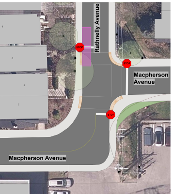
Macpherson Avenue at Rathnelly Avenue
The design reconfigures the intersection into a three-way stop-controlled intersection and allows pedestrians to safely cross Rathnelly Avenue. The proposal includes:
A permanent curb radius reduction on the southeast corner to replace the existing painted curb extension.
Narrowed and clearly marked pedestrian crossings with tactile indicators.
Relocated stop sign eastbound on Macpherson Avenue.
New stop control southbound on Rathnelly Avenue.
Reduction of two on-street permit parking spaces on Rathnelly Avenue.
No impacts to existing trees.
Macpherson Avenue at Rathnelly Avenue
Response to Feedback
Staff considered all the feedback received from the public during the consultation period for the project. Weighing public input alongside City policies, programs and technical requirements, staff revisions to the design are explained below.
Rathnelly Avenue and Macpherson Avenue
Remove east-west crossings across Rathnelly Avenue at Macpherson Avenue.
No changes to current permit parking limits.
In 2025, marked pedestrian crossings were installed at intersections further north along Rathnelly Avenue. These new crossings, in combination with the proposed traffic signals at Davenport Road/Poplar Plains Road and Macpherson Avenue should provide adequate safe pedestrian crossings in the area to balance and accommodate the particular permit parking pressure in this location.
Add a bollard west of the planned curb extension at the south-east corner of the intersection side (along Rathnelly Avenue).
The bollard will provide a vertical deterrent and visual cue for people driving along Macpherson Avenue from the south/west. Combined with the curb extension here, the bollard provides an additional physical barrier that will further deter people from turning the wrong way (eastwards) onto Macpherson Avenue.
Poplar Plains Road from Poplar Plains Crescent to Boulton
Provide a new parking area (10 parking spaces) along the west side of Poplar Plains Road between Cottingham Road and Boulton Drive with the following restrictions:
Maximum 1 hour parking from 7 a.m. to 6 p.m. Monday to Friday to provide parking space for pick-up and drop-off needs
Maximum 3 hour parking from 6 p.m. to 12 a.m. Monday to Friday and on weekends
Permit parking all days 12 a.m. to 7 a.m.
City staff will work with the Mabin School administration and discuss options for improving the pick-up and drop-off on Poplar Plains Road. This would involve a review of existing parking and stopping regulations and recommendations for by-law modifications and other measures to prevent illegal stopping on Poplar Plains Road.
A request has been submitted for Transportation Services to clear away vegetation blocking parking regulation signage along Poplar Plains Road.
Add new east-west marked crossing across Poplar Plains Road at Poplar Plains Crescent on the south side.
The recommended changes to traffic operations aim to provide space for pick-up and drop-off activities while enabling traffic flow and enabling safe passage for all road users. Other safety issues in the area were noted and will be accommodated where possible.
The turning movements for vehicles entering private driveways along Poplar Plains Road has been tested and verified. The proposed segments of curbs along the bike lane will fall on the bike lane side of the current painted white line and therefore will not reduce the width of the existing vehicle travel lane or make driveway turns different from what they are now.
Any further recommendations for adjustments to the design and parking by-laws in the area will be made following engagement with the school.
Cottingham Road and Boulton Drive
Adjust stop signs to better align with stop bars and curbs.
Better aligning stop signs to curbs should improve stop compliance at this intersection.
Davenport Road and Huron Street
Add a “Pedestrians Ahead” road sign to the eastbound approach of this intersection. The sign would be included alongside the already proposed zebra markings, crossride markings and bike lane markings through the intersection.
A traffic analysis was recently conducted by the City to assess the feasibility of higher- order traffic control at this intersection. Traffic volume and speed did not meet the warrants for a change to the current all-way stop. A combination of signage and upgraded markings at and through this intersection should help visually narrow and bring attention to the crossings to improve stop compliance to enable safer crossings for pedestrians.
Davenport Road and Macpherson Avenue and Poplar Plains Road
The proposed traffic signals at Davenport Road and Poplar Plains Road and Macpherson Avenue were received mostly positively in the public consultation period. There were concerns raised about how the signals would manage the heavy northbound left and eastbound right movements and how queuing down to Dupont Street and Davenport Road could be avoided. City staff have been assessing possible signal timing solutions to help address the demands at the intersection. Some of the key items are highlighted below:
Minor modifications to the design of the south leg to provide a longer left turn lane.
Dedicated northbound left turn signal phase and other opportunities for this turn through the signal sequence.
Minor modifications to the signal phasing at the Dupont Street and Davenport Road intersection to coordinate the flow and contain the northbound traffic.
Staff are considering an eastbound left turn prohibition (Macpherson Avenue onto Poplar Plains Road) at the intersection. This would reduce queuing along the east leg of the intersection.
The proposed design widens the vehicle lanes on the east leg slightly to accommodate concurrent northbound left and eastbound right turning movements. During the northbound left signal phases, eastbound vehicles (with the red light) would be able to stop and proceed with the right turn when it is safe.
The intersection would have a “Leading Pedestrian Interval” signal allowing pedestrians to begin walking five seconds before vehicles get the green light. This improves visibility of pedestrians and has been found to be very effective at reducing vehicle-pedestrian collisions and conflicts.
Changes that require Council approval are detailed in the Staff Report and focus on municipal road by-laws changes, such as stop controls and parking.
Other proposed safety improvements do no require council approval as they meet current standards and guidelines which have already been approved in principle such as those related to the City’s Vision Zero Safety Plan.
Public Consultation
The comment period for this consultation has closed. The Public Consultation Report summarizes feedback received.
A virtual Public Meeting was held on January 15, 2026 that included a presentation and Question & Answer period with project staff. View the presentation below.
Public opinion, along with technical and policy considerations, will be used to inform design modification, staff recommendations and decisions made by City Council.
City staff will report to the Toronto and East York Community Council on February 19, 2026 for approval of proposed by-law changes.
Stay Informed
To receive project updates by email, contact us and indicate that you would like to be added to the mailing list.
While we aim to provide fully accessible content, there is no text alternative available for some of the content on this page. If you require alternate formats or need assistance understanding our maps, drawings or any other content, please contact us at 416-338 -2985 or email aadila.valiallah@toronto.ca.