Starting July 16, weather permitting, the City will begin installation of street direction changes on Ferrand Drive, north of Windom. View the Installation Notice for details.
New and Updates
July 2026
City Council has approved the installation of street direction changes on Ferrand Drive north of Windom Road. A copy of the staff report is available at IE30.2
June 2026
City staff presented the amendment to Ferrand Drive Area Safety Improvements to Infrastructure & Environment Committee on June 10. View the staff report at IEC30.2
Feedback was invited on the proposed change from April 22 to May 5, 2026. Following the public consultation, modifications were made to the proposed design. For more information, see the ‘Approved: Ferrand Drive Amendment (2026)’ tab below.
April 2026
The City of Toronto is proposing to change the direction of motor vehicle traffic on Ferrand Drive, north of Windom Road, from one-way westbound to one-way eastbound. Learn more about this change and provide feedback by May 5, 2026. View the Project Update for more details.
July 2024
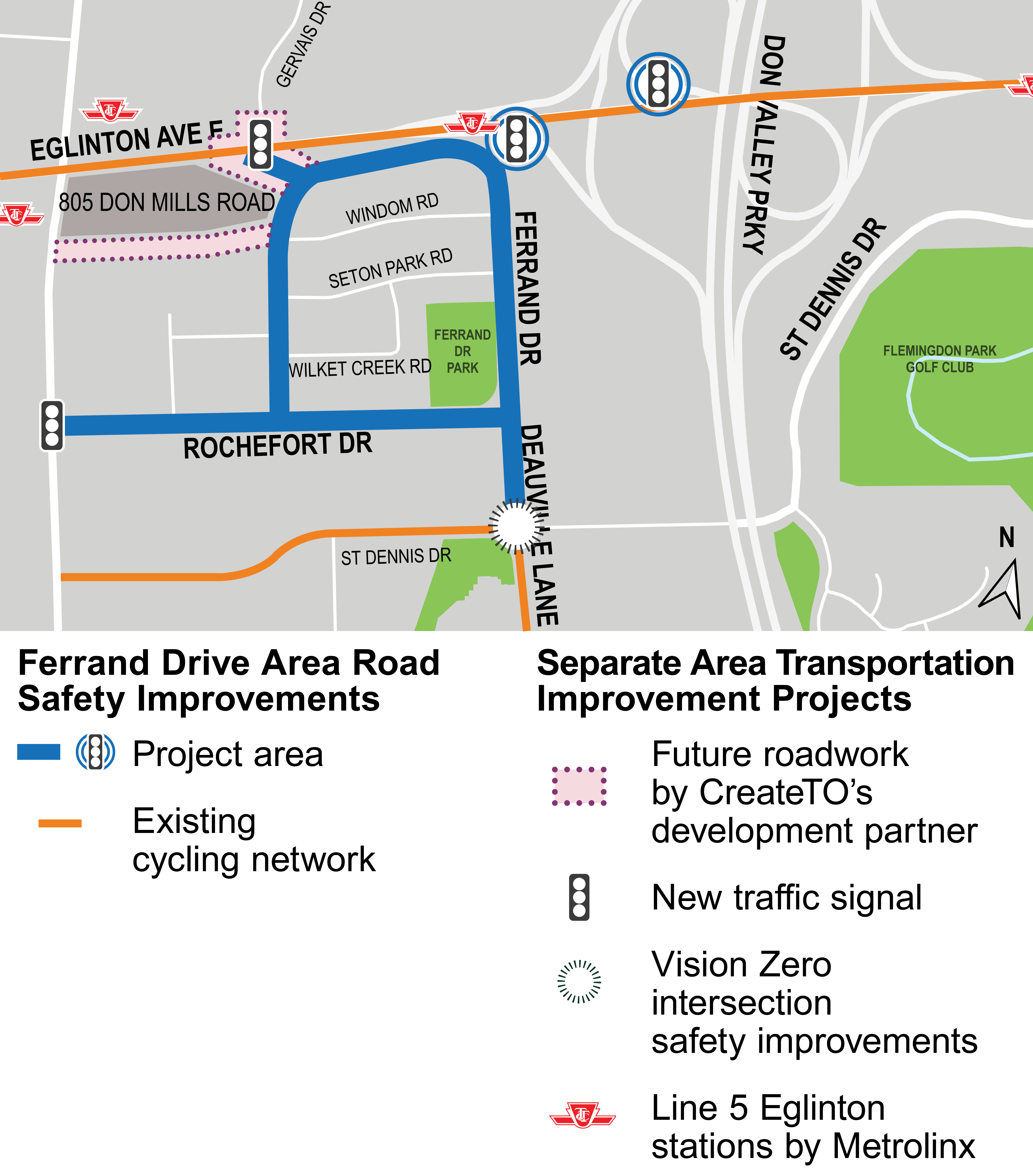
The City of Toronto is installing road safety improvements in the Ferrand Drive area, near the Don Mills Road/Eglinton Avenue East intersection. City Council approved these changes in May 2024 (2024.IE12.4) to expand the cycling network into the northern part of Flemingdon Park and improve road safety and transportation options for pedestrians and people cycling to access local destinations and rapid transit.
Project Area
The project area includes:
Ferrand Drive, Rochefort Drive and Deauville Lane (Rochefort Drive to St. Dennis Drive)
Eglinton Avenue East, at the Don Valley Parkway (DVP) southbound on-ramps
Approved: Ferrand Drive Amendment (2026)
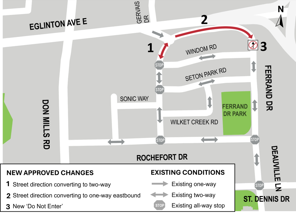
For Ferrand Drive north of Windom Road, following changes have been approved:
Existing one-way motor vehicle traffic converted to two-way traffic on Ferrand Drive, from Eglinton Avenue East on-ramp to Windom Road (west intersection)
One-way motor vehicle traffic converted from westbound to eastbound direction on Ferrand Drive, from Eglinton Avenue East on-ramp to Windom Road (east intersection)
No motor vehicle access northbound, north of Windom Road at the east intersection of Ferrand Drive and Windom Road
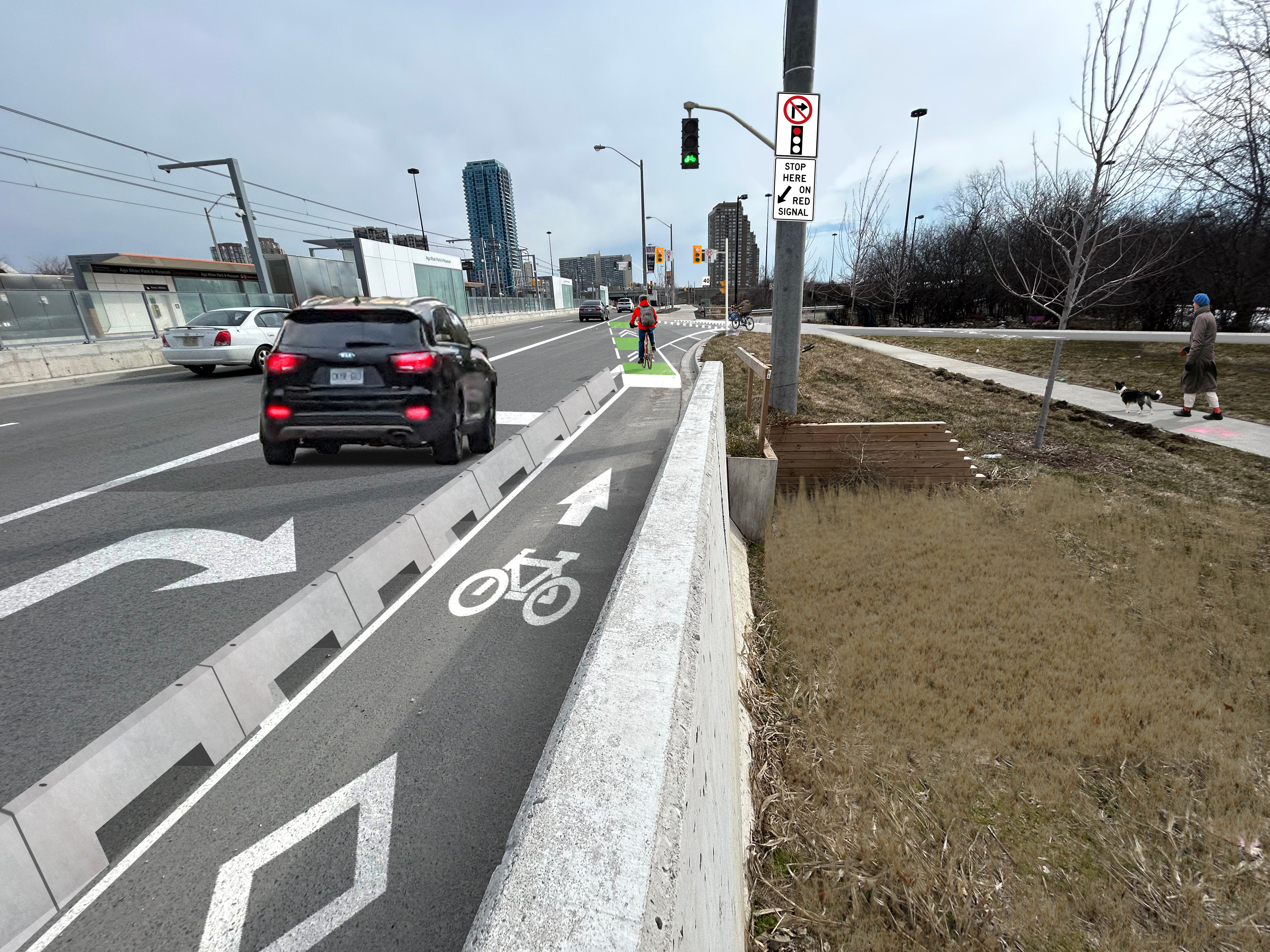
Installed: Ferrand Drive Off-ramp, from Eglinton Avenue East to Ferrand Drive
CreateTO’s development partner for 805 Don Mills Road will add northbound and southbound bike signals after reconstructing the Eglinton Avenue East/Gervais Drive/Ferrand Drive intersection, expected to be completed in 2029.
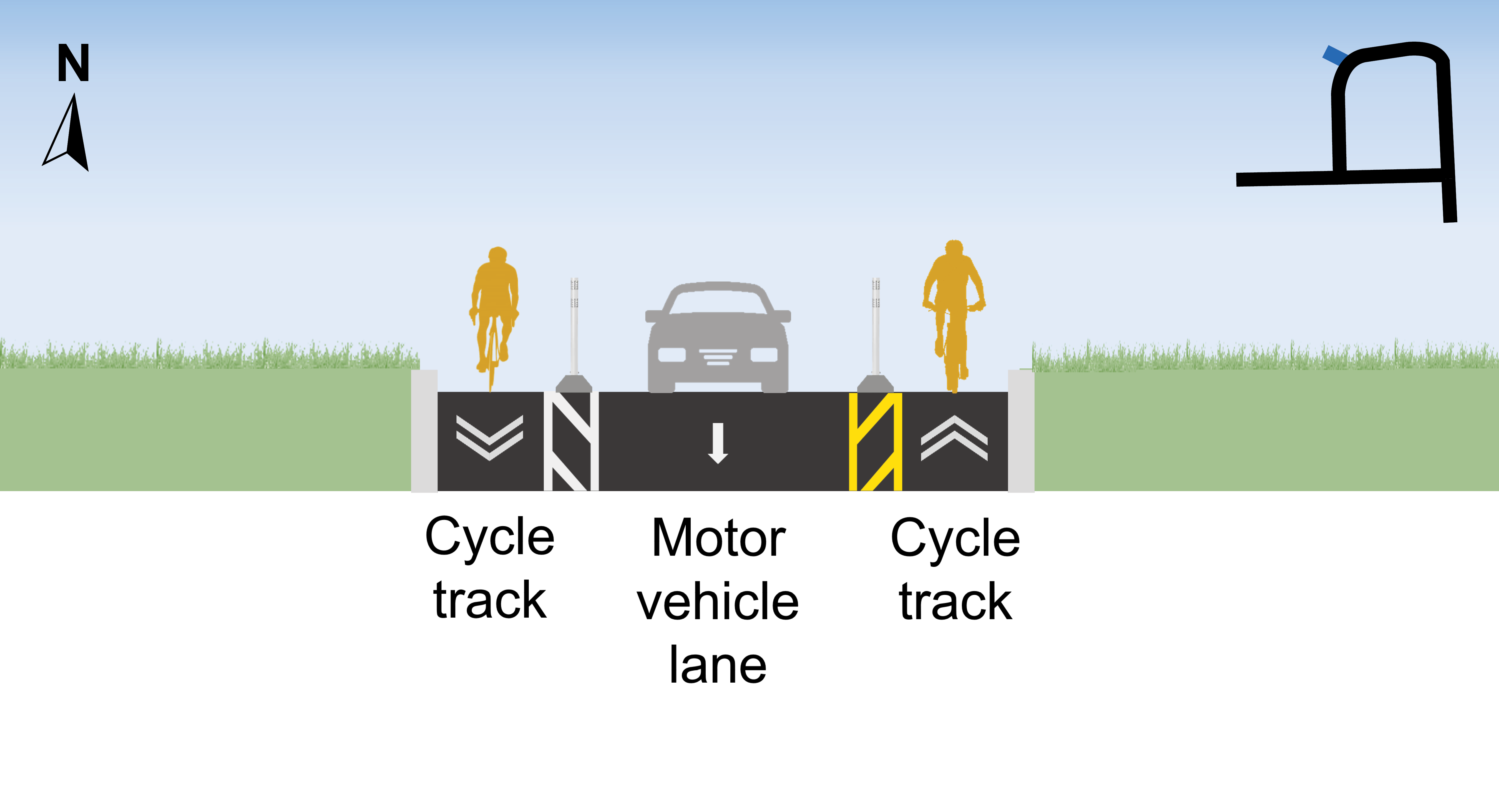
For the Ferrand Drive Off-ramp, from Eglinton Avenue East to Ferrand Drive, the following design has been installed:
One-way cycle tracks on both sides of the road with flexible bollard and precast concrete curb separation
No changes to the one-way eastbound entry for motor vehicles from Eglinton Avenue East
Speed limit reduced from 50 km/h to 30 km/h
Cross section of the installed design of the Ferrand Drive off-ramp, from Eglinton Avenue East to Ferrand Drive, facing north.
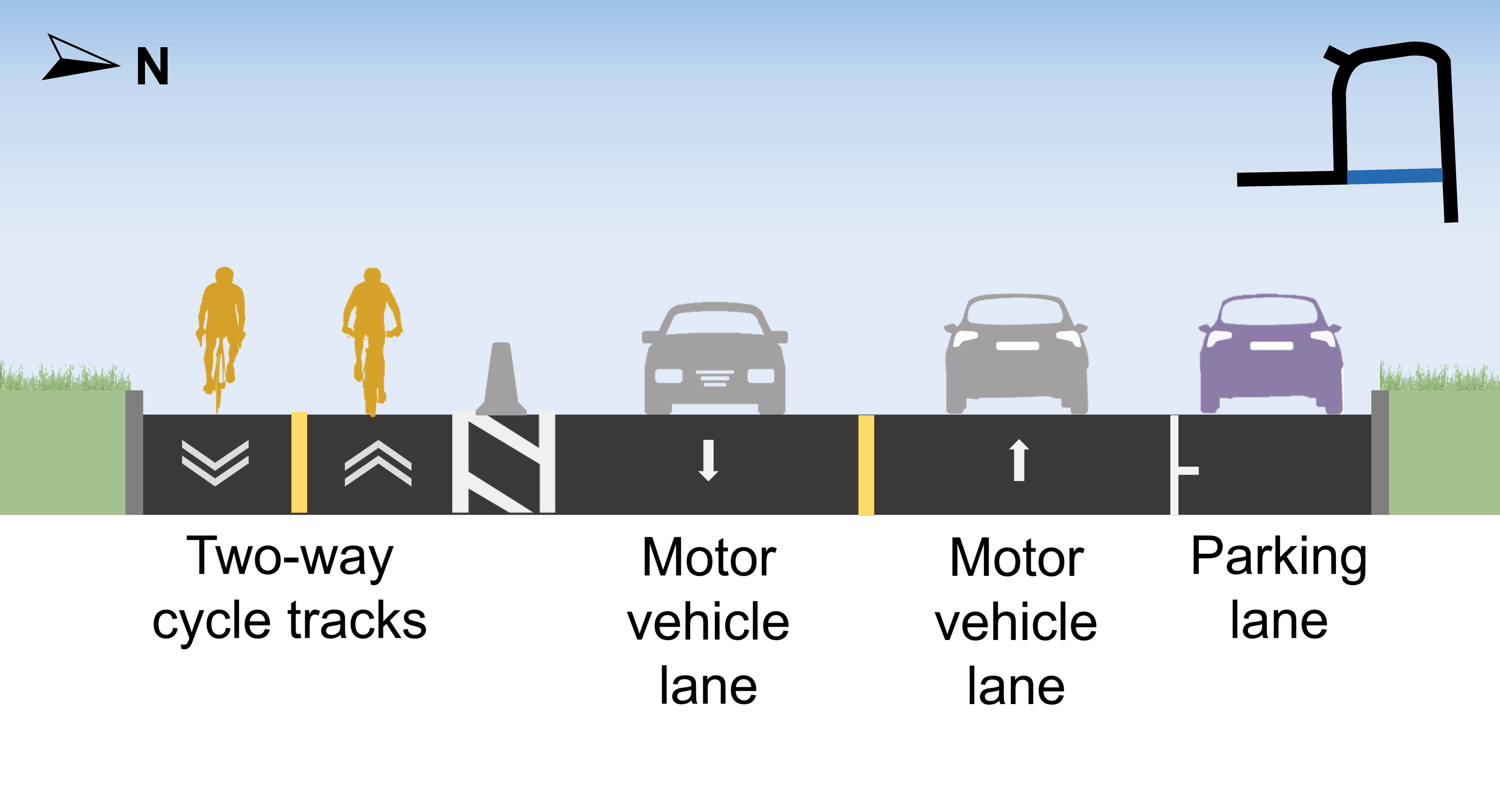
Installed: Ferrand Drive
For Ferrand Drive, the following design has been installed:
The new travel movement in the project area.
East Segment
One-way cycle tracks on both sides of the road with flexible bollard and precast concrete curb separation
On-street parking will be removed
Speed limit reduced from 50 km/h to 30 km/h
Cross section of the installed design on the east segment of Ferrand Drive, facing north.
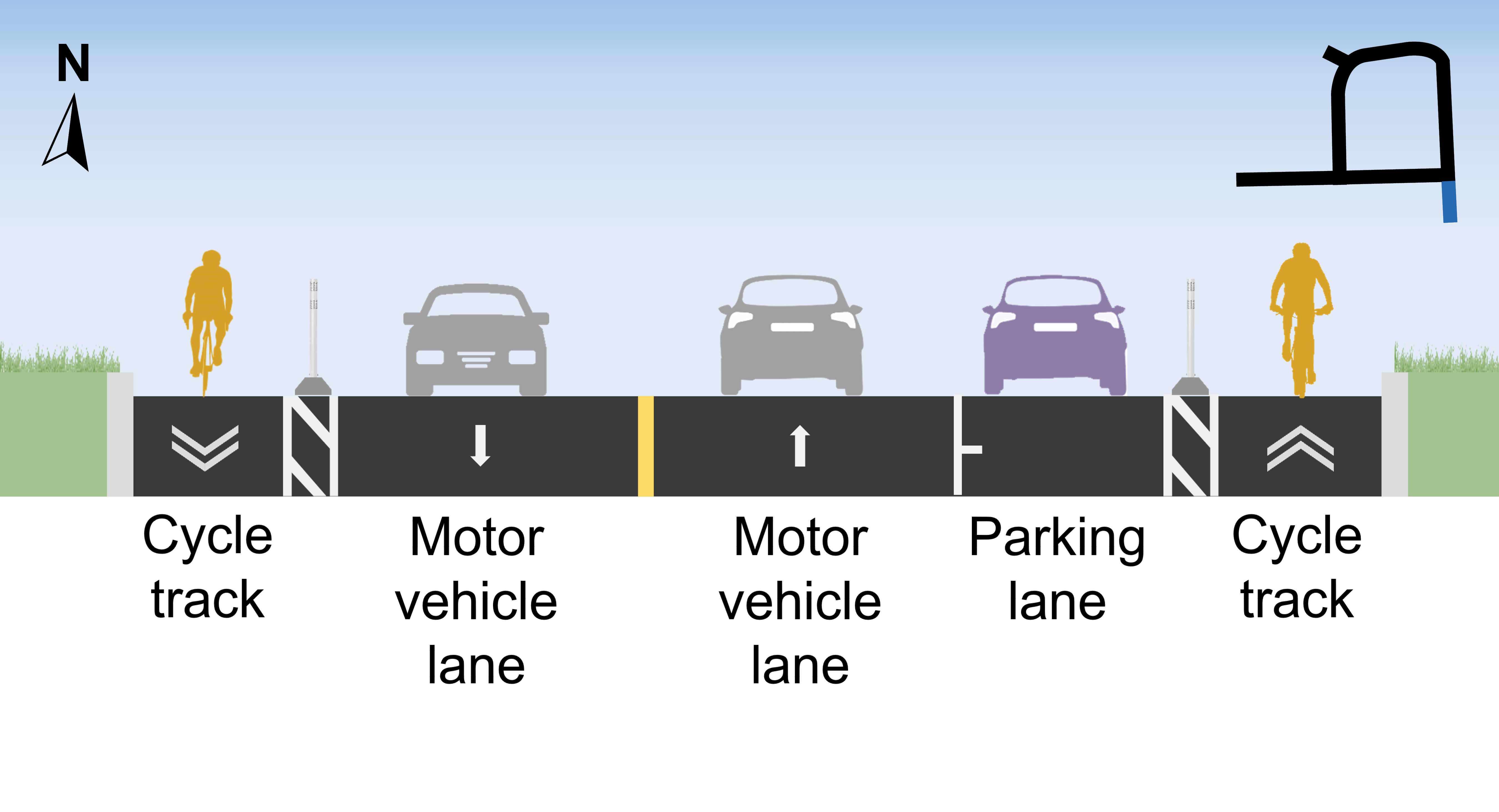
Top segment
Two-way motor vehicle lanes will be converted to one-way westbound
Installation of cycle tracks with paint, flexible bollards and precast concrete curb separation in both directions
Speed limit reduced from 50 km/h to 30 km/h
Cross section of installed design on the top segment of Ferrand Drive, facing west.
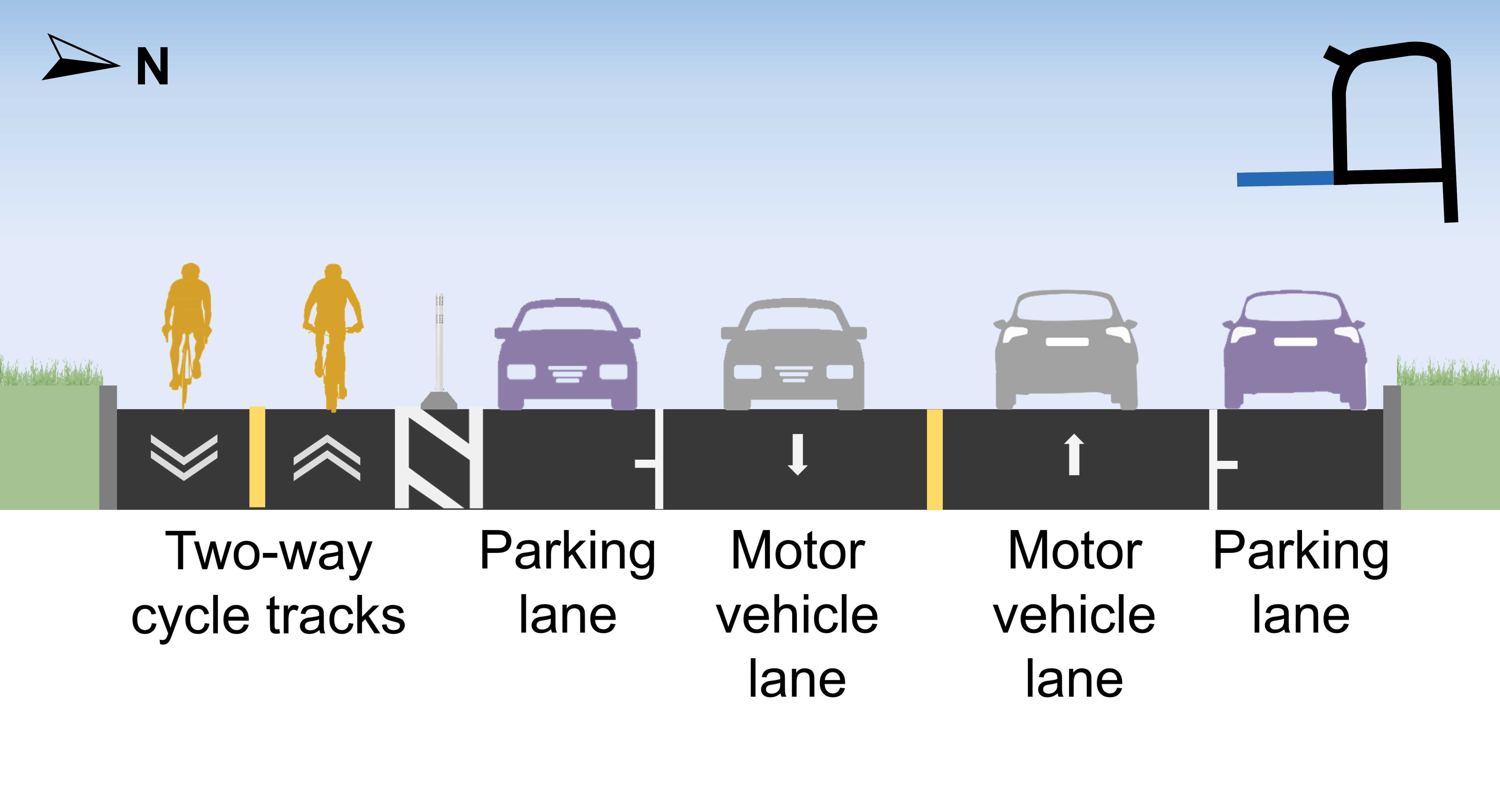
West segment
Installation of one-way cycle track with flexible bollards and precast concrete curbs on both sides where parking is not permitted
Six on-street parking spaces are retained on the west side between Windom Road and Sonic Way and shared lane markings will be painted for the southbound direction
New stop signs and painted crosswalks at the west intersections of Ferrand Drive/Windom Road, Ferrand Drive/Seton Park Road and Ferrand Drive/
Rochefort Drive
Speed limit reduced from 50 km/h to 30 km/h
Cross section of the installed design on the west segment of Ferrand Drive, facing north.
Installed: Rochefort Drive, from Deauville Lane/Ferrand Drive (east segment) to Ferrand Drive (west segment)
For Rochefort Drive, from Deauville Lane/Ferrand Drive (east segment) to Ferrand Drive (west segment), the following design has been approved:
Two-way cycle tracks with flexible bollards and concrete barriers added on the south side
Loading access maintained on the north side through a parking lane
Speed limit reduced from 50 km/h to 30 km/h
Cross section of the installed design on Rochefort Drive, from Ferrand Drive (east segment)/Deauville Lane to Ferrand Drive (west segment), facing west.
Installed: Rochefort Drive, from Ferrand Drive (west segment) to Don Mills Road
For Rochefort Drive, from Ferrand Drive (west segment) to Don Mills Road, the following design has been installed:
Two-way cycle tracks on the south side with flexible bollards and precast concrete curbs
Removal of five parking spaces
No changes to existing loading access
Speed limit reduced from 50 km/h to 30 km/h
Cross section of the installed design on Rochefort Drive, from Ferrand Drive (west segment) to Don Mills Road, facing west.
Installed: Deauville Lane, from Rochefort Drive to St. Dennis Drive
For Deauville Lane, from Rochefort Drive to St. Dennis Drive, the following design has been installed:
One-way cycle tracks on each side of the street with flexible bollards and precast concrete curbs
No changes to parking, with loading access maintained on the east side through a
parking lane
Speed limit reduced from 50 km/h to 30 km/h
Cross section of the installed design on Deauville Lane, from Rochefort Drive to St. Dennis Drive.
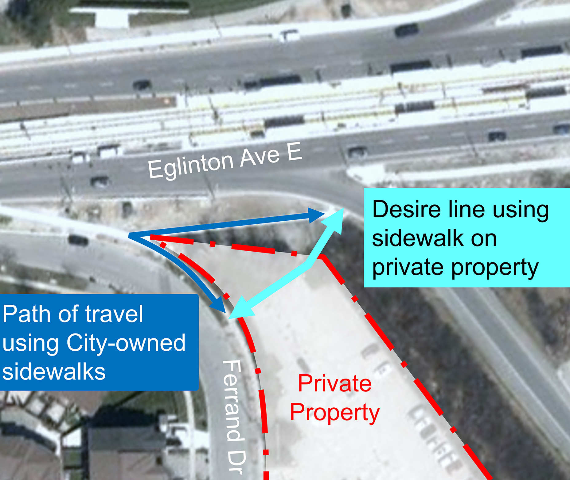
Approved Long-Term Changes (2025+): Ferrand Drive to Eglinton Avenue East Connection
For Ferrand Drive to Eglinton Avenue East and with the property owner’s support, the following change has been approved and a design is being explored:
Installation of a two-way pedestrian and cycling connection between Ferrand Drive and Eglinton Avenue East.
Aerial view of the desire line from Ferrand Drive to Eglinton Avenue East.
Approved Long-Term Changes (2025+): Eglinton Avenue East, at the Don Valley Parkway Southbound On-ramps
For Eglinton Avenue East, at the Don Valley Parkway southbound on-ramps, the following design is approved:
Installation of new traffic signals across two DVP southbound on-ramps, with the long-term plan to include road safety improvements at all four on-ramps.
Artistic rendering of the planned design on Eglinton Avenue East at the southbound on-ramp, facing east.
Public Consultation
Response to Feedback
The City has monitored feedback from community representatives, businesses and the public, including feedback on potential changes to the design. This feedback was reviewed, compared with technical considerations, and includes site observation before designs are finalized for installation.
Feedback received identified overall support for the proposed changes, however, residents in the project area shared some concerns about the proposed removal of on-street parking spaces, particularly on the west segment of Ferrand Drive.
Following consultation and in discussion with the local Councillor, the following changes were made to the design on Ferrand Drive:
East segment: Converting on-street parking spaces to cycle tracks in both directions (originally proposed in Option 1)
Top segment: Converting two-way motor vehicle lanes to one-way westbound and adding cycle tracks in both directions (originally proposed in Option 1)
West segment: Adding a one-way cycle track, while retaining seven on-street parking spaces and adding all-way stops and pedestrian crosswalks at the Ferrand Drive/Seton Park Road intersection (originally proposed in Option 2)
Consultation Overview
Public consultation on this project took place in 2023. The report below provides a detailed summary of all activities that took place and feedback received:
In the Ferrand Drive Area, there are a number of long-term projects moving forward recommended in the Don Mills Crossing Secondary Plan that will change the transportation network. There are also two rapid transit lines, one in construction and the other in design by Metrolinx. Both will change transportation options in the area.
Separately, a development at 805 Don Mills Road is planned that will realign the Eglinton Avenue East/Ferrand Drive/Gervais Drive intersection in anticipation of increased motor vehicle traffic connections to streets in this area.
In the past 10 years on the streets proposed for design changes in the Ferrand Drive area, there have been 122 reported collision, in which seven have involved pedestrians and three have involved people cycling. The changes proposed through this project are focused on expanding road safety improvements and cycling to the long-term planned projects and on reducing future collisions.