The City of Toronto is carrying out a study to identify sewer and watermain infrastructure within Mimico Creek that is at risk of damage due to erosion impacts as a result of high flows from storms and snow melt.
This study looks at how the City’s storm sewer and watermain infrastructure can be protected within the creek using recommended solutions to help reduce or prevent future impact. This will ensure the City’s infrastructure continues to operate and service residents and businesses. The solutions will be part of a Mimico Creek Geomorphic Systems Master Plan for the creek that is implemented over a multi-year period.
The geomorphology of a stream examines how natural and human factors have shaped its form and function over time. Erosion can affect the path a stream follows (form) and the aquatic and terrestrial habitats the stream supports (function). Erosion results in gradual changes to the form and function of the stream and stream bed. Significant changes to water levels contribute to increased erosion.
During storm events, rain water or snow melt runoff enters underground pipes via drains and catch basins on streets and in parks and is discharged from storm sewer outfalls into watercourses that flow to Lake Ontario. At times these flows can be high, resulting in erosion damage. High flows from past storms have caused substantial erosion damage to sewers and watermains located in and near the City’s ravines and watercourses.
This erosion damage can:
To learn more about erosion in streams and rivers, view the Understanding Streams information deck.
The map below shows the location of Mimico Creek and area under study.
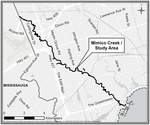
The study area includes the 19 km length of Mimico Creek in Toronto from Highway 427 near Disco Road and Attwell Drive to where it meets Lake Ontario.
Study Purpose
The purpose of the study is to develop a Geomorphic Systems Master Plan (GSMP) for Mimico Creek that will include recommendations for stabilizing the creek and protecting water infrastructure from erosion. The study will:
The study will not examine trail conditions or recommend improvements to trails, forestry or ravine amenities.
Study Process
This study will follow the Municipal Class Environmental Assessment process for Master Plans, an approved planning process under the Ontario Environment Assessment Act and includes opportunities for public input.
This study includes the following key steps:
As part of the study, 203 water infrastructure sites were assessed, including:
The level of erosion risk has been assessed at each site:
Very Low-Risk Sites
Low-Risk Sites
Medium-Risk Sites
High-Risk Sites
Very High-Risk Sites
Based on the risk assessment of water infrastructure sites, protection for the 25 most at-risk sites is recommended. Following an evaluation of alternative solutions, fourteen projects are being proposed to address the 25 most at-risk sites.
The following alternative solutions to stabilize the creek bed and banks were evaluated for the identified 25 sites in the study area:
Alternative 1: Do nothing (no planned interventions, only ongoing monitoring)
Alternative 2: Improvements through local works less than 100 metres
Alternative 3: Improvements to a segment of the creek greater than 100 metres
Potential solutions were evaluated based on whether the alternative solution achieved the following:
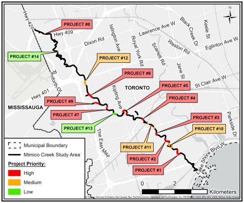
The City is recommending 14 projects to stabilize the bed and banks of the creek through natural channel design:
The 14 projects were assigned priority levels for implementation. Exposed sanitary sewers are the highest priority projects as they pose greater negative impacts if broken as compared to broken storm sewer outfalls or watermains:
For more detailed information on the recommended projects, view the Mimico Creek Presentation in the Public Consultation section below.
Future implementation of the recommended projects requires:
Construction impacts will be communicated prior to project implementation.
Public Consultation took place May 27 – June 28,2024. A Virtual Public Meeting was held on Monday June 12, 2024. Members of the public were provided with an overview of the study, had the opportunity to review recommended solutions, ask questions and provide feedback.
Following public consultation, an Environmental Study Report will be prepared with the final study recommendations. The study report will be posted on the project webpage for a 30-day public comment period.
The study results will be shared with the City’s Parks, Forestry and Recreation division and Toronto Region Conservation Authority for coordination and collaboration to advance a long-range plan for Mimico Creek.
In 2021 the City of Toronto carried out emergency work to replace the Van Dusen Boulevard Pedestrian Bridge over Mimico Creek and rehabilitate a portion of Mimico Creek in the area of Van Dusen Boulevard. That work is now complete. Additional needs will be address as part of the Mimico Creek Geomorphic System Master Plan.
To receive project updates by email, please email mimicocreek@toronto.ca and indicate that you would like to be added to the mailing list.