City Council endorsed, in principle, the Parkside Drive Study on November 13 and 14, 2024. A copy of the staff report is available at IE17.4. This report summarized the findings from the Parkside Drive Study and the study recommendations to implement a road safety focused redesign project which includes a bikeway, intersection safety improvements at Lake Shore Boulevard West and Bloor Street West, new and updated Toronto Transit Commission bus stops, and designated turning lanes at intersections.
Phase Two public consultation took place between January 3 and February 15, 2023. Potential interim changes and long-term vision for Parkside Drive were presented to road users and the community for feedback. Consultation activities included a community group meeting, public drop-in event, and survey. The phase two Public Consultation report is posted under Public Consultation below.
The first phase of public consultation for the Parkside Drive Study was an opportunity to receive feedback from the public on existing conditions, concerns and priorities for Parkside Drive. Feedback was received via survey, email and phone and was carried out in conjunction with the High Park Movement Strategy. Consultation took place from July 8 to August 29, 2022. The phase one Public Consultation report is posted under Public Consultation below.
The study area was Parkside Drive from Keele Subway Station to Lake Shore Boulevard West.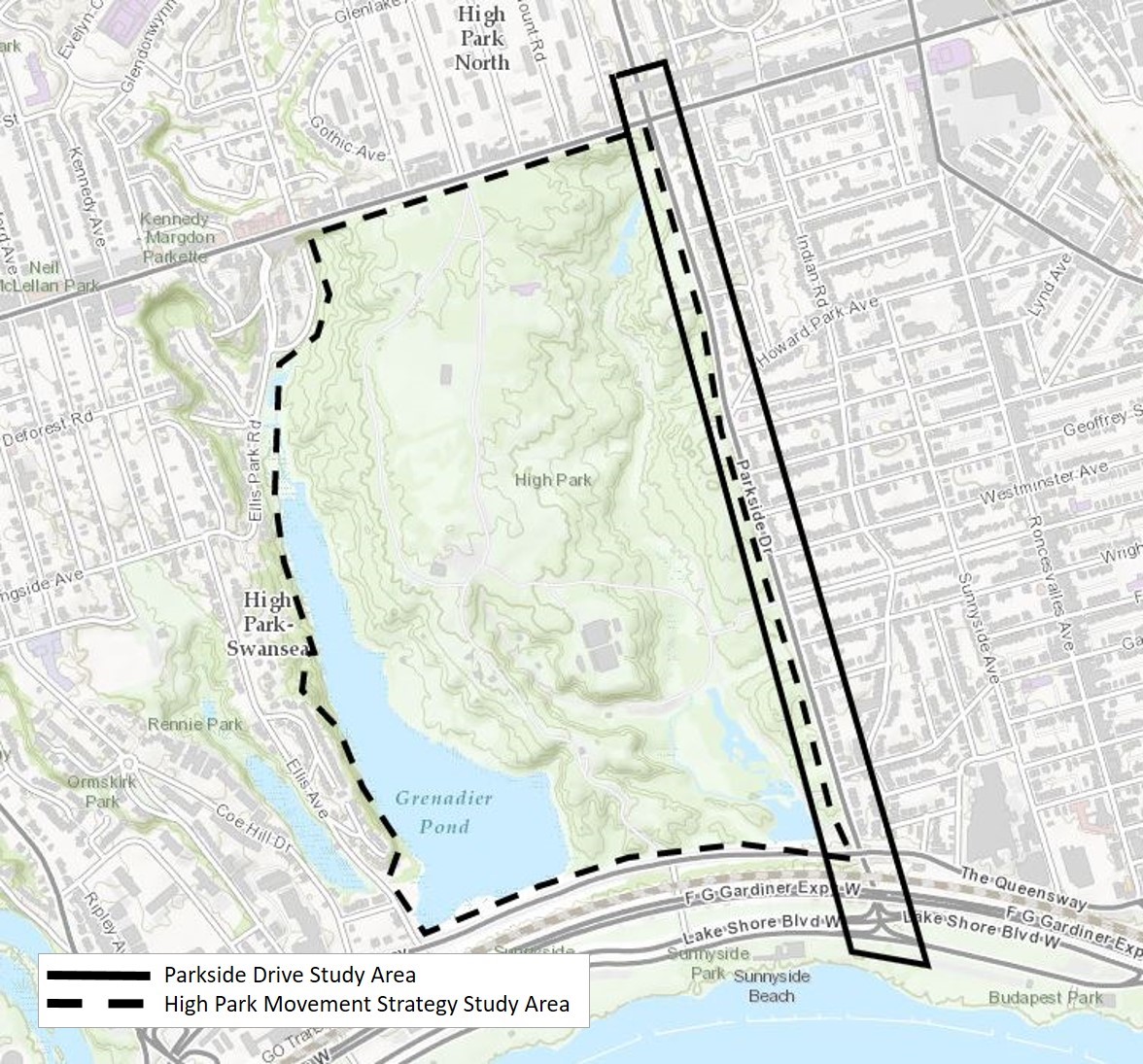
The Parkside Drive Study built on community advocacy for improved road safety. Between August 2014 and August 2024 there were seven collisions that resulted in five serious injuries and three fatalities. All seven collisions involved vulnerable road users. Narrow and missing sidewalks, lack of bikeways, excessive vehicular speeds and aggressive driving, and a history of collisions resulting in fatality or serious injury are frequently heard concerns. The Parkside Drive Study recommendations support the City’s Vision Zero Road Safety Plan efforts to implement changes that prevent serious injuries and fatalities on our streets.
The objectives of the Parkside Drive Study were to:
Next Steps
A road safety focused redesign project was endorsed in principle by City Council. Road safety changes include:
The design includes two-way cycle tracks on the west side of Parkside Drive between Bloor Street West and Lake Shore Boulevard West with the provision of full-time parking and loading opportunities on the east side where feasible.
Cycle tracks would improve the comfort and safety of all road users, particularly people cycling and pedestrians. The two-way cycle tracks require a reduction in the number of mid-block motor vehicle travel lanes from three to two and inclusion of a third lane at intersections where needed to accommodate designated left-turn lanes at all intersecting streets that permit eastbound movements.
The capacity for motor vehicle traffic at the intersection of Bloor Street West and Parkside Drive would remain unchanged with four motor vehicle lanes and dedicated left-turn lanes to help manage motor vehicle traffic flow, minimize queuing and discourage motorists utilizing local neighbourhood streets to avoid the intersection.
The design supports speed management by narrowing motor vehicle travel lanes to current standards. Slower motor vehicle speeds would improve safety conditions for pedestrians and people cycling and are an integral component of the Vision Zero Road Safety Plan‘s key focus action to implement a Speed Management Strategy.
The preliminary design, conceptual plans and potential cross-sections are available in the staff report.
Toronto and East York Community Council authorized the installation of speed humps on five local roads adjacent to Parkside Drive at the meeting on October 22, 2024.
Speed humps will be installed on the following streets within one to two years:
Transportation Services also reviewed the need for speed humps on other roads in the neighbourhood. The assessment indicated that the warrant criteria, as set out in the City’s updated Traffic Calming Policy, had not been satisfied. Staff recommend that the warrant criteria be reevaluated at a future time, should there be a change in traffic patterns in the area.
Details are available in the staff report.
Public consultation was conducted throughout the Parkside Drive Study to collect feedback and input from residents and community interest groups. The feedback gathered through consultation informed staff recommendations, along with technical considerations and City policies and guidelines.
Various outreach methods were used to notify the public of the consultation activities, including a project webpage, over 14,000 flyers distributed through Canada Post, mailed meeting invitations to residents of Parkside Drive, e-notifications to the project’s mailing list, and notices in the local Councillor’s newsletter.
Consultation activities included:
The goal of phase one was to review existing conditions, identify concerns and priorities.
The goal of phase two of consultation was to present the public with a future vision for the road and potential interim improvements and receive feedback.
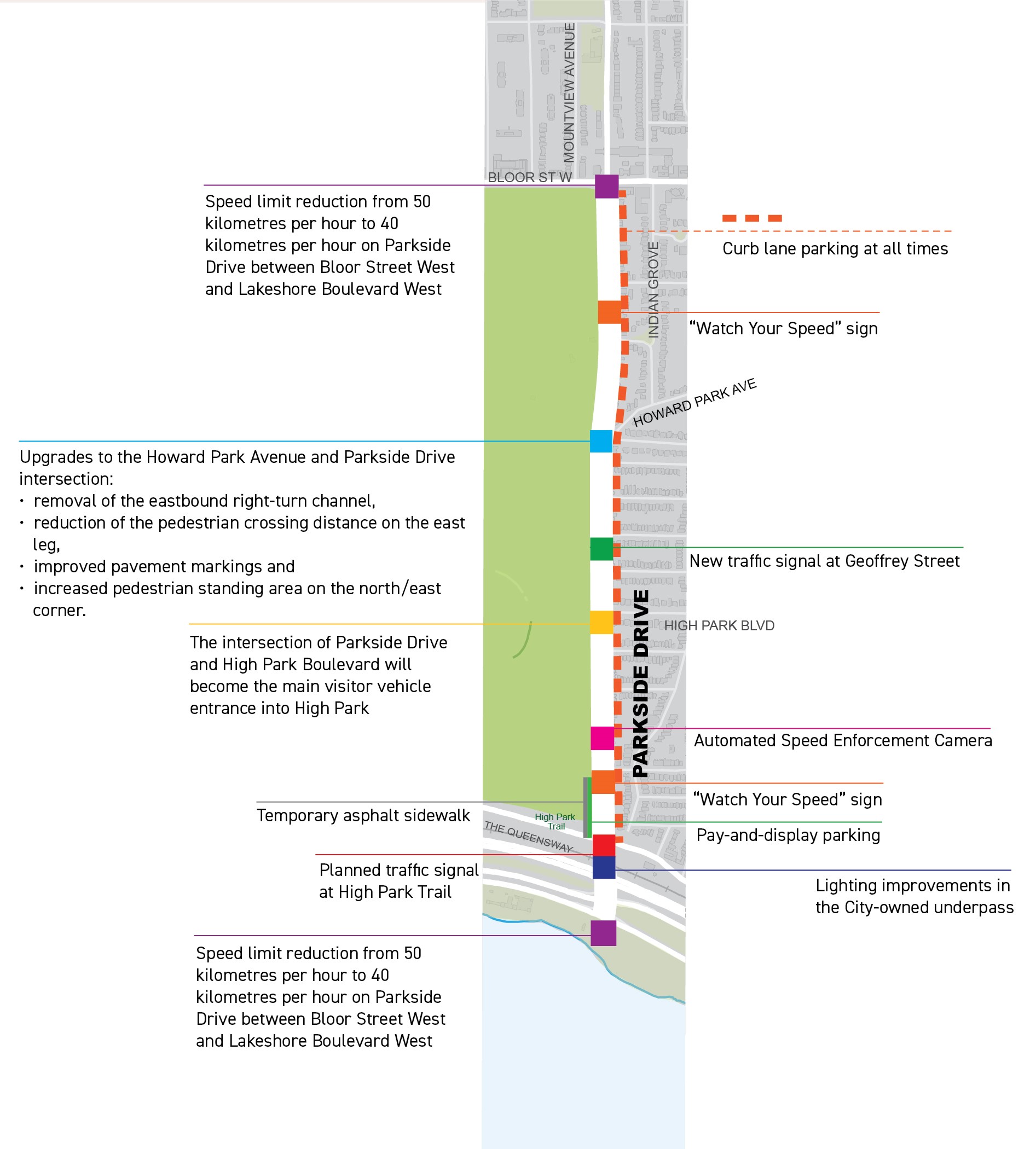
Between 2021 and 2023, the City made several improvements along Parkside Drive to improve the safety of vulnerable road users and reduce motor vehicle speeding.
The Parkside Drive Study builds on recent and planned roadway changes, City Council decisions and community requests, including:
Changes to vehicle speed and volume
Data collected between 2017 and 2023 suggest that motor vehicle speeds and volumes decreased since changes were implemented on Parkside Drive.
Between 2021 – 2023, following the implementation of community-requested changes, southbound vehicle speeds decreased by approximately 17%, from 62km/hr to 51 km/hr, northbound vehicle speeds decreased by approximately 13% from 55km/hr to 48km/hr.
Between 2017 – 2023 motor vehicle volumes decreased by approximately 27% from over 28,000 daily motor vehicles to approximately 21,000 daily motor vehicles.
Sign-up to receive project updates and learn about consultation opportunities via email.