The City of Toronto has installed a cycling route along Portland Street – across the Puente De Luz pedestrian/cycling bridge – and down Dan Leckie Way. These changes are part of the City’s Cycling Network Plan to improve road safety and build connected cycling routes. City Council approved the project in April 2024 (IE12.4.) and completed installation in Spring 2026.
Use this map to determine how to best navigate where you need to go.
June 5, 2026 – Installation Update
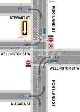
This week the City began installing neighbourhood traffic and signal changes on Portland Street, between Queen Street and Front Street, including new one-way street segments and a traffic diverter at the Portland Street and Wellington Street intersection which are intended to reduce non-local traffic. It is expected that once people driving become accustomed to the new traffic patterns, spots currently experiencing congestion will subside.
Previously, deliveries, loading and pick-up/drop-off for day and nighttime activities on Portland Street were taking place along both sides of the street, which often stalled north and southbound vehicles from being able to pass each other, leading to considerable honking and neighbourhood disruption. With the newly installed one-way configuration, loading is consolidated on the east side of Portland Street, ensuring an unimpeded flow of traffic. Additionally, a designated Uber pick-up/drop-off area has been created on the east side of Adelaide Street ,just north of King Street, to help minimize the circulation of rideshare vehicles disrupting residential parts of the neighbourhood, particularly at night.
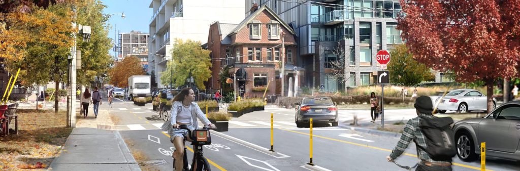
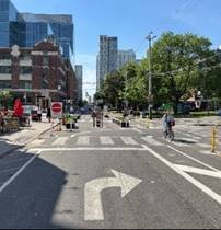
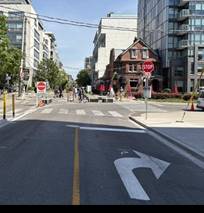
The traffic diverter at Portland Street and Wellington Street is a critical component of the project to improve safety for all road users. Between 2015 and today, there were 544 traffic collisions tracked on Portland Street between Front Street and Queen Street, involving 23 pedestrians and 43 cyclists, and 26 older adults and 17 school aged children. These collisions resulted in 103 injuries including 8 serious injuries.
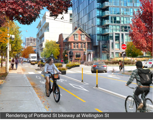
The recently installed design minimizes the many conflicting movements between motor vehicles, pedestrians and people travelling on bicycles along the corridor and in particular through the Portland / Wellington intersection, while maintaining motor vehicle access to all properties and slowing bicycles to more easily yield to pedestrians and other bicycle traffic.
As a result of the intersection change, the following traffic movements are permitted at the Portland / Wellington diverter:
| Southbound on Portland: Right Turn Only | Northbound on Portland: Right Turn Only | Westbound on Wellington: Left Turn Only |
 |
 |
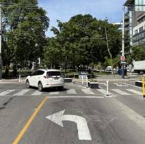 |
First responders and other authorized vehicles may still pass through the intersection if required, and emergency response times are not expected to be impacted by the new design. The design also allows authorized vehicles supporting Ontario Line construction to pass through slowly. City of Toronto Traffic Agents will support safe access for these authorized vehicles during weekdays. Digital wayfinding apps such as Waze, Google Maps, and Apple Maps have all been updated to reflect the recent changes.
The majority of the installation is complete or wrapping up this week including:
The City is closely monitoring traffic pattern changes in coordination with RapidTO as well as impacts on Bathurst Street and Spadina Avenue, and will continue to conduct traffic counts and on-site observations. In particular, during afternoon peak hours, traffic flow westbound on Wellington Street at Bathurst Street is constrained due to the substantial number of pedestrians and people cycling crossing Bathurst during the green light westbound. The City is investigating opportunities to adjust signal timing to increase motor vehicle movement and reduce congestion on Wellington Street.
April 2026 – Installation Notice
The portion of the Portland-Dan Leckie bikeway on Portland Street from Queen Street to Front Street, is planned for installation starting the week of April 30 2026 (weather dependent). Key changes include:
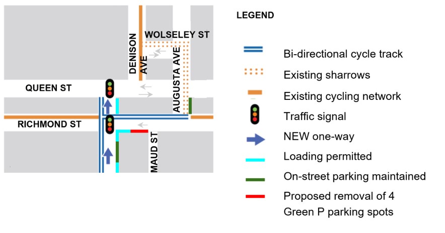
Based on public feedback, the block of Portland Street from Wellington Street to Front Street will remain two-way for motor vehicles.
Project Delays
In 2024, the Dan Leckie segment of the Portland-Dan Leckie project was installed as planned, but the Portland segment was deferred to accommodate the heaviest volume of construction vehicles using Portland Street for a hauling route during excavation for the King/Bathurst Ontario Line Station. This heaviest hauling period was completed in December 2025, and the Portland bikeway began installation in spring 2026.
The traffic diverter at Portland Street and Wellington Street is a critical component of the project to improve safety for all road users. Between 2015 and today, there were 544 traffic collisions tracked on Portland Street between Front Street and Queen Street, involving 23 pedestrians and 43 cyclists, and 26 older adults and 17 school aged children. These collisions resulted in 103 injuries including 8 serious injuries.
The recently installed design minimizes the many conflicting movements between motor vehicles, pedestrians and people travelling on bicycles along the corridor and in particular through the Portland / Wellington intersection, while maintaining motor vehicle access to all properties and slowing bicycles to more easily yield to pedestrians and other bicycle traffic.
As a result of the intersection change, the following traffic movements are permitted at the Portland / Wellington diverter:
| Southbound on Portland: Right Turn Only | Northbound on Portland: Right Turn Only | Westbound on Wellington: Left Turn Only |
|
|
|
First responders and other authorized vehicles may still pass through the intersection if required, and emergency response times are not expected to be impacted by the new design. The design also allows authorized vehicles supporting Ontario Line construction to pass through slowly. City of Toronto Traffic Agents will support safe access for these authorized vehicles during weekdays. Digital wayfinding apps such as Waze, Google Maps, and Apple Maps have all been updated to reflect the recent changes.
For details on navigating the new one-way street segments, please review the most recent project update and the detailed project map 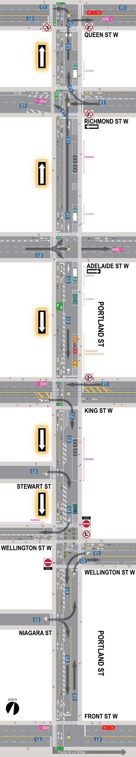 .
.
Previously, deliveries, loading and pick-up/drop-off for day and nighttime activities on Portland Street were taking place along both sides of the street, which often stalled north and southbound vehicles from being able to pass each other, leading to considerable honking and neighbourhood disruption. With the newly installed one-way configuration, loading is consolidated on the east side of Portland Street, ensuring an unimpeded flow of traffic. Additionally, a designated Uber pick-up/drop-off area has been created on the east side of Adelaide Street ,just north of King Street, to help minimize the circulation of rideshare vehicles disrupting residential parts of the neighbourhood, particularly at night.
The City is closely monitoring traffic pattern changes in coordination with RapidTO as well as impacts on Bathurst Street and Spadina Avenue, and will continue to conduct traffic counts and on-site observations.
Transit and transportation investments including RapidTO Bathurst, the Ontario Line and safe and intuitive cycling infrastructure are an integral part of transportation planning to sustainably accommodate growing populations.
The Portland street bikeway and traffic improvements is part of an integrated transportation plan to minimize neighbourhood traffic infiltration. The introduction of one-way streets and the diverter at Portland and Wellington make Portland Street a local-traffic only street and reduces cut-through traffic between Front Street to Queen Street. Preliminary findings show that RapidTO Bathurst has not substantially increased volumes on neighbourhood streets, and work continues to address adjustments at intersections to improve traffic flow along Bathurst Street.
The City has been closely monitoring the traffic impacts of several recent development projects in the area. Most recently, the completion of The Well development, expected to be a generator of 22,000 trips per day, has not impacted local motor vehicle volumes on Wellington Street or Portland Street. The Portland bikeway and new neighbourhood traffic patterns will be well established before King Street streetcar track work commences.
Based on public feedback, the block of Portland Street from Niagara Street to Front Street remains two-way for motor vehicles. The installed design features:
Based on public feedback, the Northbound one-way segment of Portland Street will extend from Adelaide Street to Queen Street. The installed design features:
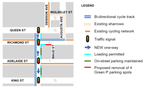
The installed design features:
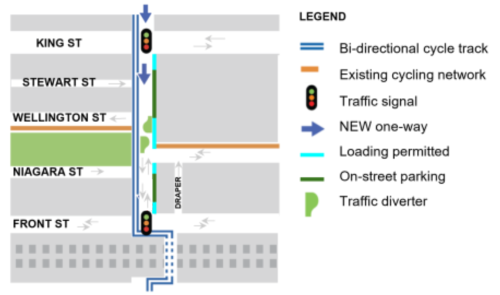
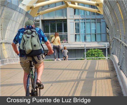
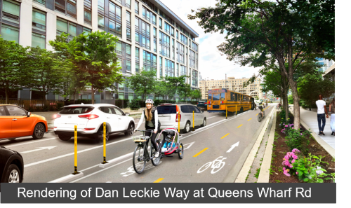
The bridge connects the north and south segments of the Portland – Dan Leckie bikeway. Cyclists must yield to pedestrians while crossing the bridge.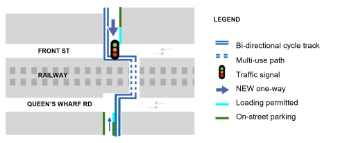
The installed design features:
The installed design features:
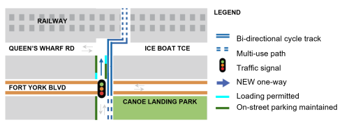
North of Fort York Boulevard
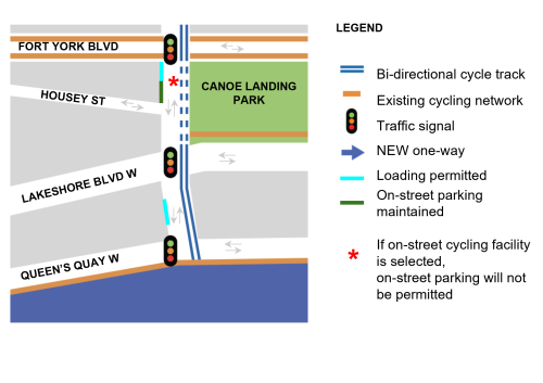
South of Fort York Boulevard
Please note that the the formal consultation period is now closed, materials, information and reports on past consultation are available in the links below.