City Council has approved some changes recommended through The Peanut Streets Plan. Staff reports to the City Council and North York Community Council are available here 2026.NY32.17 and 2026.NY32.16
Other recommendations will be presented to North York Community Council in early 2027.
In consultation with the local community, the City is developing a Neighbourhood Streets Plan for The Peanut area that will address three main areas of concern:
Road safety for vulnerable road users (e.g. pedestrians, children, older adults and people cycling)
Excessive speeding
Excessive motor vehicle traffic on local streets
We want to hear from people in the area about their transportation safety concerns. Your input can help us plan changes to improve the local streets.
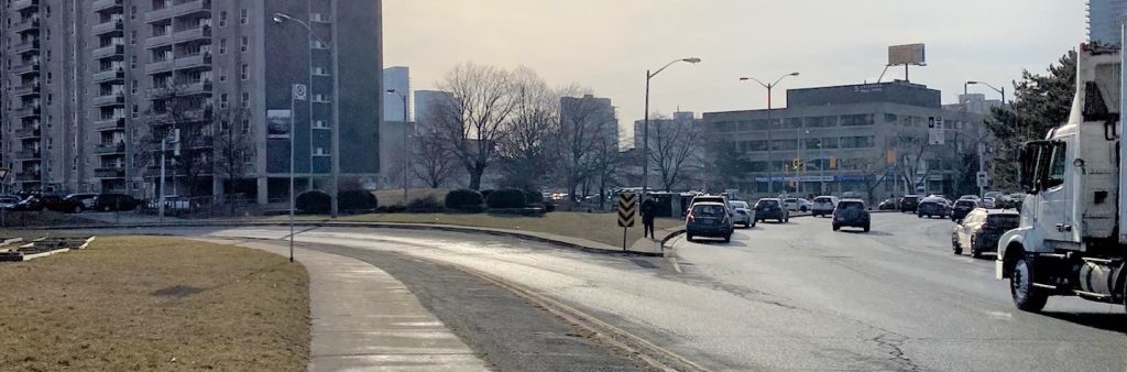
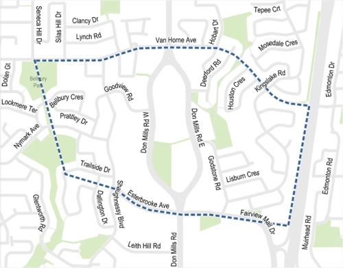
Project Area
The project area is located between Van Horne Avenue to the north, Highway 404 to the east, Esterbrooke Avenue and Fairview Mall Drive to the south and Bellbury and Lescon Parks trail system to the west.
Background
The Peanut Streets Plan will:
Consider the needs of all road users in the neighbourhood including vulnerable road users (e.g. pedestrians, children, older adults and people cycling).
Assess network-wide transportation needs throughout the neighbourhood, and coordinate with existing and planned future connections.
Develop solutions that, together, support local and City of Toronto objectives for mobility and safety.
Identify opportunities for short-term action that can be implemented with quick-build materials.
Identify opportunities for long-term changes alongside planned road resurfacing or reconstruction.
What is a Neighbourhood Streets Plan?
Neighbourhood Streets Plans (NSPs) service neighbourhoods where traffic and travel patterns challenge the safety and mobility of people using the streets. Through the NSP process, a team of City staff work with communities to identify local issues and opportunities, prioritize the greatest needs, and recommend changes to traffic operations and street designs. NSPs consider the needs of all road users and emphasize the safety of vulnerable road users such as seniors, school children, and people walking and cycling.
Each year dozens of nominations are received and five neighbourhoods are prioritized to participate in the program.
Process
NSPs follow several steps outlined below, and public consultation takes place in two stages.
Step 1: Public consultation on local issues & ideas
Step 2: Develop actions & changes to address issues
Step 3: Public consultation on proposed actions & changes
Step 4: Finalize plan for approval by Community Council
Step 5: Implement short-term actions
Step 6: Monitor, evaluate, and update community on future changes
NSPs result in short-term actions which can be made using temporary, flexible materials like signs, asphalt, paint, and bollards, and identify longer term changes which can be accomplished alongside future programmed road work.
The outcomes of each NSP are different based on local conditions and the needs of each neighbourhood. Generally, NSPs recommend actions related to motor vehicle speed and volume management, and traffic safety conflicts on local streets. NSP recommendations are informed by the City’s Traffic Calming Guide, Vision Zero Action Plan, and Complete Streets Guidelines.
Public Consultation
The City of Toronto is inviting local residents, businesses, and organizations to learn more and provide feedback. Consultation will take place over two stages between Spring 2024 to Fall 2025.
Phase 1: will consult the community on issues commonly experienced in the neighbourhood and ideas for actions and changes
Phase 2: will consult the community on proposed short-term actions (1 to 2 years) which can be made using temporary, flexible materials like signs, paint, and bollards, and will identify longer term changes which can be accomplished alongside future programmed road work
Information, reference materials, and reports on public consultation activities will be posted here. Public and interest group opinions, along with technical and policy considerations, are used to inform City staff recommendations and decisions to be made by City Council.
Phase 2 Public Consultation.
View below the project information panels and a report summarizing feedback received in Phase 2.
Proposed Changes: Lack of Direct and Safe Pedestrian Crossings
Residents have raised concerns about the long distances between pedestrian crossings in the neighbourhood, which often lead to pedestrians crossing at unmarked locations and creating safety concerns for all road users. Changes proposed to address lack of safe and direct pedestrian connections and improve pedestrian safety and accessibility, include:
New/upgraded midblock pedestrian crossings, on:
Fairview Mall Drive near Allenbury Gardens park
New crosswalk markings, on:
South segment at both intersections of Van Horne Avenue and O’Shea Crescent
North segment of the intersection of Van Horne Avenue and Clancy Drive
South segment of the intersection of Esterbrooke Avenue and Shaughnessy Boulevard
North and south segments of the intersection of Godstone Road and Kempsell Crescent
North and south segments of the intersection of Kingslake Road and Godstone Road
Improvements to The Peanut northern Island
Proposed improvements to The Peanut northern Island include adding a curb ramp and a wider refuge space at the access point from Van Horne Avenue.
In addition, the City is exploring the following two options to improve safety:
Elimination of vehicle access to the slip lane
Curb extensions to improve safety for Bellbury Park Trail users, at the following intersections:
Bellbury Crescent and Bellbury Park Trail
Nymark Avenue and Bellbury Park Trail
Approved Changes: Lack of Direct and Safe Pedestrian Crossings
City Council has approved the following changes to address lack of safe and direct pedestrian connections and improve pedestrian safety and accessibility:
New/upgraded midblock pedestrian crossings, on:
Don Mills Road West, near the trail access to Oriole Park, Oriole Community Centre and schools north of the park, at the southeast corner of The Peanut
Van Horne Avenue near Hobart Park Trail
Improvements to The Peanut northern Island
Addition of a crossing between the Island and the Plaza
Proposed Changes: Signal Timing
Residents have raised concerns about lack of safe crossing conditions and missed turning phases for people driving due to signal timing. The City has already made some improvements, including new traffic signals and pedestrian crosswalks, at:
Don Mills Road & Godstone Road
Don Mills Road & Deerford Road
Additional signal locations under review to address the inadequate signal crossing time include:
Don Mills Road near The Peanut Plaza and O’Shea Walkway
Signal near 2988 Don Mills Road
Proposed Changes: Cycling Infrastructure
Residents have raised concerns about lack of safe cycling infrastructure in the neighbourhood. The Council-approved Toronto Cycling Network Plan’s 2025-2027 Near-Term Implementation Program already identifies cycling routes for study on Don Mills Road and Fairview Mall Drive.
To address the lack of cycling safety and connectivity, the Streets Plan proposes upgrades to the existing cycling shared cycling facilities on Van Horne Avenue, and identifies additional cycling routes for study in the neighbourhood, on:
Esterbrooke Avenue
Godstone Road between Godstone Park Trail and Fairview Mall Drive
Lescon Park Trail
East-west connection at The Peanut
Proposed Changes: Excessive Speeding and Other Concerns
Residents have raised concerns about excessive vehicle speeds on several residential streets in the study area. Changes proposed to address excessive speeding include speed humps and in-road speed signs at several locations in the project area. Proposed changes include:
New speed humps for traffic calming, at:
Kingslake Road between Godstone Road and Van Horne Avenue
Nymark Avenue between Shaughnessy Boulevard and Glentworth Road
Godstone Road between Fairview Mall Drive and Don Mills Road
Van Horne Avenue between Don Mills Road to Leslie Street
Goodview Road between Don Mills Road and Nymark Avenue
In-road speed signs, at:
Shaughnessy Boulevard near Goodview Road
Residents have also raised concerns about road safety, traffic flow, and conflicts between pedestrians and vehicles during school pick-up and drop-off times at several locations in the project area. Changes proposed to address these concerns include:
All-way stop signs, at the following intersections:
Van Horne Avenue and Silas Hill Drive
Van Horne Avenue and Shaughnessy Boulevard
Kingslake Road and Godstone Road
Access restriction to Lescon Road from Trailside Drive has been proposed for school drop-off and pick-up times, to address motor vehicle traffic and volume
Email Updates
To receive project updates by email, please contact PeanutStreets@toronto.ca to be added to the list.