PATH – Toronto’s Downtown Pedestrian Walkway
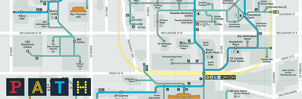
The PATH is a mostly underground pedestrian walkway network in downtown Toronto that spans more than 30 kilometres of restaurants, shopping, services and entertainment.
The walkway facilitates pedestrian linkages to public transit, accommodating more than 200,000 business-day commuters as well as tourists and residents. The PATH provides an important contribution to the economic viability of the city’s downtown core.
While the City of Toronto aims to provide fully accessible content, there is presently no text based alternative available for some of the content in this map. If you require alternate formats or need assistance understanding this map, please call the Financial District BIA at 416-849-3856 or email info@torontofinancialdistrict.com.
- With 3.7 million square feet of retail space, there are 1,200 restaurants, shops and services in the PATH, generating roughly $1.7 billion in sales annually. An estimated 4,600 jobs are located in the PATH. The PATH generates approximately $271 million in federal, provincial, and municipal tax revenue annually.
- More than 75 buildings are connected to the PATH. Six subway stations, three major department stores, nine hotels, and Toronto’s busiest transit hub – Union Station – are accessible through the PATH. The PATH provides links to some of Toronto’s most popular tourist and entertainment attractions, including the Hockey Hall of Fame, Roy Thomson Hall, the Scotiabank Arena and CF Toronto Eaton Centre. City Hall and Metro Hall are also connected through the PATH.
- Each segment of the walkway system is owned and controlled by the owner of the property through which it runs. There are about 35 corporations involved.
- It is possible to walk through the PATH from the waterfront to Downtown Yonge, and from the Entertainment District to Yonge St. all of which connect through Toronto’s world class Financial District.
- The first underground path in Toronto originated in 1900 when the T Eaton Co. joined its main store at 178 Yonge St. and its bargain annex by tunnels. By 1917 there were five tunnels in the downtown core. With the opening of Union Station in 1927, an underground tunnel was built to connect it to the Royal York Hotel (now known as the Fairmont Royal York). The real growth of PATH began in the 1970s when a tunnel was built to connect the Richmond-Adelaide and Sheraton Centres.
- In 1987, City Council adopted the recommendation that the City become the co-ordinating agency of PATH and pay for the system-wide costs of designing a signage program.
- In 1988, design firms Gottschalk, Ash International, and Keith Muller Ltd. were retained in by the City of Toronto to apply the design concept for PATH.
- PATH’s name and logo are registered to the City of Toronto. The City co-ordinates and facilitates the directional signage, maps and identity markers throughout the system.
- In the early 1990s, signage for PATH was developed to provide pedestrians with better ease of use and functionality. The signage enhances PATH’s visibility and identity, ultimately increasing its use, attracting more people to downtown Toronto, and drawing more businesses there.
- In 2016-2017, the City of Toronto and Toronto Financial District BIA hired Steer Davies Gleave to develop a new PATH Wayfinding system. Extensive public consultations, conversations with property managers and review by the PATH Partnership Group resulted in the new PATH wayfinding installed throughout the PATH in spring 2018.