The project has been delayed due to improvements to the Bathurst Street Bridge and rail improvements surrounding the project site. Construction is anticipated to start in fall 2024.

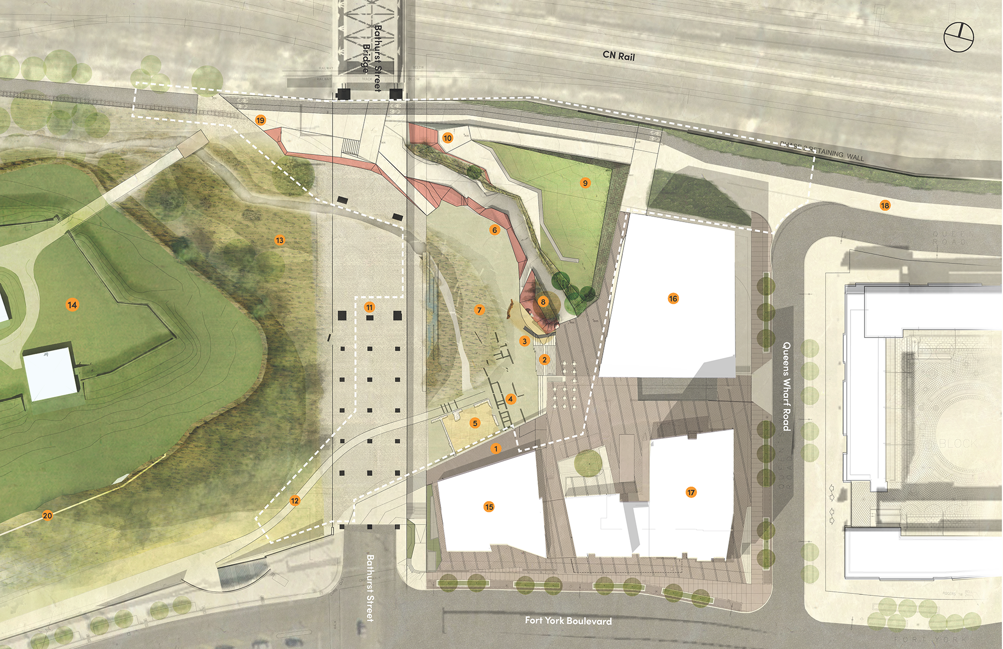
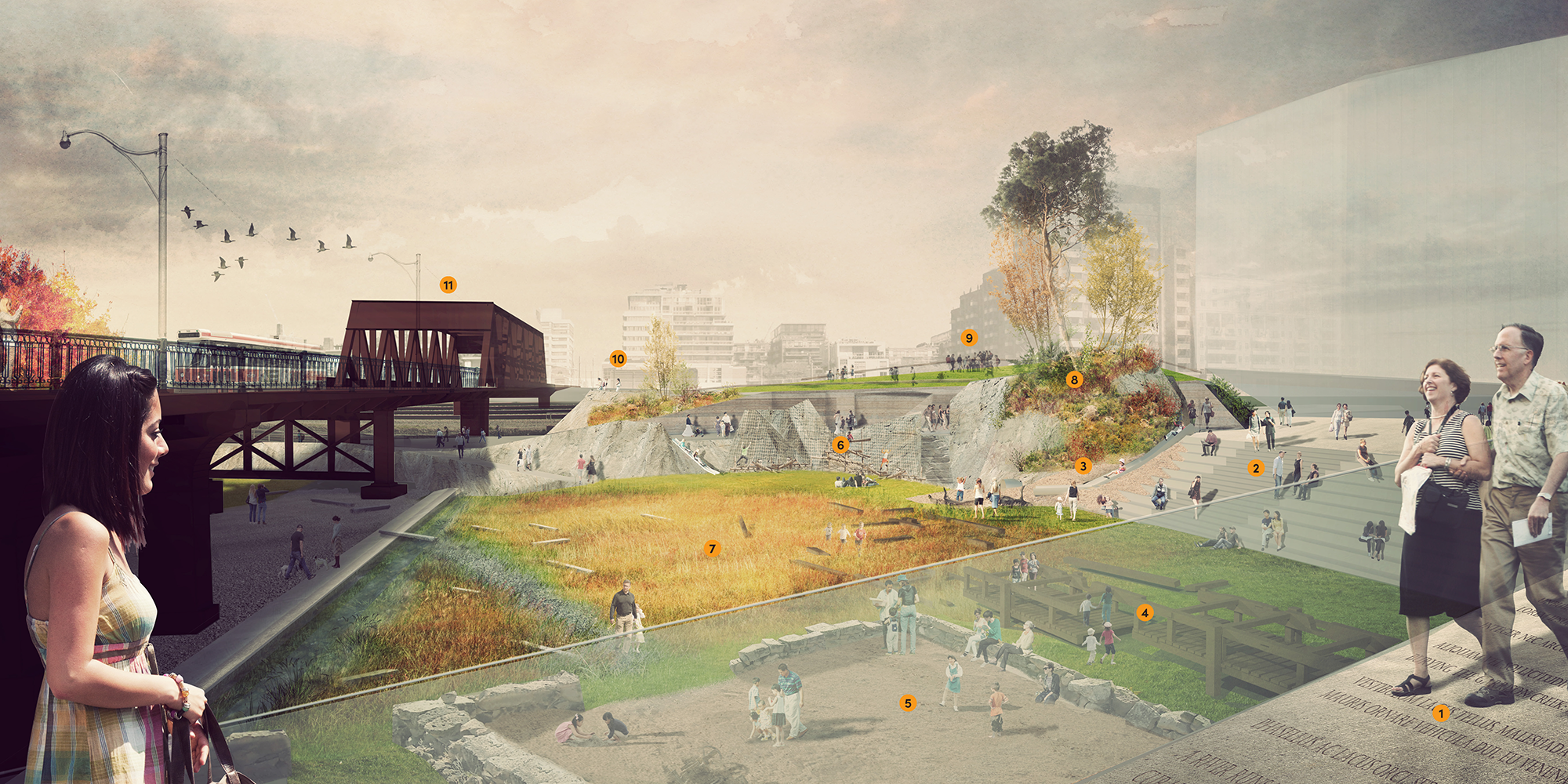
A new 5,300 m2 (1.3 acres) park is coming to 170 Queens Wharf Rd. in the CityPlace neighbourhood, east of the Bathurst Street Bridge, as a result of a subdivision development project. The park design, created through extensive community engagement from 2012 to 2015, was finalized in 2018 to celebrate Fort York’s heritage. It uniquely references the circa 1800 landscape, including the Lake Ontario shoreline and Garrison Creek.

While we aim to provide fully accessible content, there is no text alternative available for some of the content on this site. If you require alternate formats or need assistance understanding our maps, drawings, or any other content, please contact Bob Duguid at 416-895-9921.

  • Spring 2024: Hire a construction team
  • Fall 2024: Construction starts
  • Summer 2026: Construction complete, park opens

The timeline is subject to change.

Sign Up for Updates

Sign Up Now

Sign up for or unsubscribe from updates related to Lower Garrison Creek Park.

Community engagement to help determine the park design took place from 2012 to 2015. During the engagement process, the park was referred to as Mouth of the Creek Park, until it was officially named Lower Garrison Creek Park.

December 2015

Public Meeting

On December 16, the final park design was shared with the public at a public meeting.

The meeting presentation is not in an accessible format so cannot be posted publicly at this time. If you would like access to this document, please contact the Senior Project Coordinator.

May 2013

Public Meeting

On May 15, approximately 35 community members participated in a public meeting at the Community Hall at 150 Dan Leckie Way. The draft concept design for the new park was presented and feedback was collected in order to refine the design. The key themes that emerged from this meeting include:

  • Overall positive feedback on the draft concept design from community members in attendance
  • Prioritizing access to the park and connectivity with all existing elements in the community
  • Prioritizing user safety, including the separation of children’s play and dog use

The meeting presentation is not in an accessible format so cannot be posted publicly at this time. If you would like access to this document, please contact the Senior Project Coordinator.

March 2013

Public Meeting

On March 5, approximately 35 community members participated in a public meeting at Blue Barracks Fort York where the project was introduced and feedback on the proposed concept design was collected for the new park. The key themes that emerged from this meeting include:

  • Identifying core uses for the park, given its small size, rather than accommodating a long list of activities
  • Ensuring the park serves as both a destination and a throughway for travel

Download the March 5 meeting summary for more information.

Site Plan

The preferred design for the new park, which shows the surrounding CityPlace and Fort York neighbourhood.

Arial of the park site plan with numbered labels throughout. The fort york historic site is on the west side, the CN rail is at the north, the condo development at the east, and the Toronto public library along Fort York Boulevard to the south.

  1. Library terrace
  2. Stairs
  3. Slides built into the slope/embarkment
  4. Wharf themed play
  5. Archeological play
  6. Wall climbing play
  7. Garrison Lowlands (stormwater bio-retention)
  8. The Point embankment with planting
  9. Promontory green
  10. Lookout
  11. Bathurst Street Bridge
  12. Path connection
  13. Garrison Lowlands West
  14. Fort York National Historic Site
  15. Toronto Public Library Fort York Branch
  16. 150 Queens Wharf Rd.
  17. Library District Condo
  18. North linear park towards downtown
  19. Pathway to Garrison Common and Fork York pedestrian bridge
  20. Original Lake Ontario shoreline
Rendering of the park design with numbered labels taken from the lookout, with the Bathurst Street Bridge on the left.
Rendering of the park design from the library terrace.
  1. Library terrace
  2. Stairs
  3. Slides built into the slope/embarkment
  4. Wharf themed play
  5. Archeological play
  6. Wall climbing play
  7. Garrison lowlands (stormwater bio-retention)
  8. The Point embankment with planting
  9. Promontory green
  10. Lookout
  11. Bathurst Street Bridge