Share your experiences in the Vale of Avoca by participating in a virtual mapping activity and short survey. The activity closes on October 22, 2026.
The City, in partnership with Toronto and Region Conservation Authority (TRCA), is studying ways to improve the Vale of Avoca (also known as the Yellow Creek Ravine), located near Yonge Street and St. Clair Avenue East. The project will evaluate and prioritize improvements to how visitors access, move through and experience the ravine while reducing impacts of erosion and flooding.
The project builds upon the Yellow Creek Geomorphic Systems Master Plan, completed in 2025.
The timeline is subject to change.
Participate in the virtual mapping activity and complete a short survey to share your experiences in the Vale of Avoca.
A summary of the feedback will be shared on this page.
Sign up for or unsubscribe from updates related to the Vale of Avoca Ravine Improvements.
This project has been classified as an Involve project based on the International Association for Public Participation Spectrum. This means the City works directly with the public, stakeholders and rightsholders throughout the process to ensure that ideas and aspirations are understood and considered in the design of improvements.
In this phase, the City will work with the community and the Project Working Group to understand user experience and priorities for the Vale of Avoca ravine. This information, along with technical knowledge of the site, will be used to establish project objectives and inform design options for ravine improvements.
The community engagement activities anticipated in this phase include:
On October 7, the project team held an open house at Deer Park Public Library to share information panels about the project and respond to questions from attendees. 73 community members attended.
Download the October 7, 2026, open house panels.
The Project Working Group met three times to establish an understanding of the project status and timeline, to share updates on technical work and community engagement plans, and to establish a Terms of Reference for the group.
The meetings took place in person on:
In this phase, the City will gather feedback from the community and the Project Working Group on design options for ravine improvements. This feedback will help inform the development of a preferred design.
The community engagement activities anticipated in this phase include:
In this phase, the City will share the preferred design with the community on this webpage and through the project mailing list. The project will then move into detailed design, where the design team will work through technical details and plans for the construction contractor.
The community engagement activities anticipated in this phase include:
The Midtown Ravine Group (MRG) is a registered charity created by ten local residents’ associations to raise consciousness about the state of midtown ravines, raise funds for improvements and mobilize community participation in ravine stewardship. MRG plans to fundraise and contribute funds to support the Vale of Avoca Ravine Improvements project.
Under direction from City Council (2025.MM32.15 and 2025.MM32.22), the City is collaborating with MRG on ravine priorities and recommended designs through the Vale of Avoca Ravine Improvements Project Working Group. The Project Working Group is comprised of representatives from MRG, the Toronto Region and Conservation Authority and City staff. It provides feedback, guidance and advice to the project team at key milestones during the design and community engagement process.
With authority from City Council (2026.MM43.23), City staff will also develop agreements with MRG to enable fundraising and donations in support of City-approved and City-delivered projects that improve ravine health, resiliency and trail user experience.
A donation is a voluntary gift, either cash or in-kind, made without expectation of commercial benefit.
To ensure fairness and transparency:
The Donations to the City for Community Benefit Policy provides City staff with a guiding framework for considering donations:
The City regularly works to refine and deliver projects funded through donations. Read about the Donations to the City of Toronto for Community Benefits Policy.
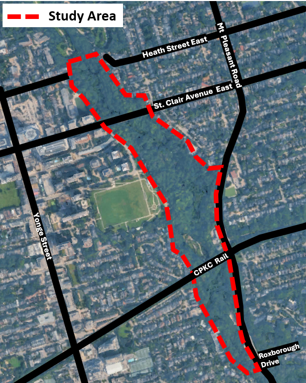
The Vale of Avoca ravine is located west of Mount Pleasant Road and stretches from Heath Street East in the north to Roxborough Drive in the south. It connects to David A. Balfour Park, Mount Pleasant Cemetery and the Mud Creek/Beltline Trail system.
Within the study area, the Toronto Region and Conservation Authority is also planning construction of the Yellow Creek erosion control, slope stabilization and Heath Crescent staircase improvements. The Vale of Avoca ravine improvements are being closely coordinated with this work, which is expected to start in early 2027.