The City of Toronto has completed a Municipal Class Environmental Assessment (MCEA) study to identify solutions to protect sewer and watermain infrastructure within Yellow Creek that is at risk of damage as a result of erosion caused by high flows from storms and snow melt.
This study looked at how the City’s storm sewer and watermain infrastructure can be protected within the creek to help correct existing impacts and reduce or prevent future impact. This will ensure the City’s infrastructure continues to operate and service residents and businesses. The solutions will be part of a Geomorphic Systems Master Plan (GSMP) for the creek that is implemented over a multi-year period.
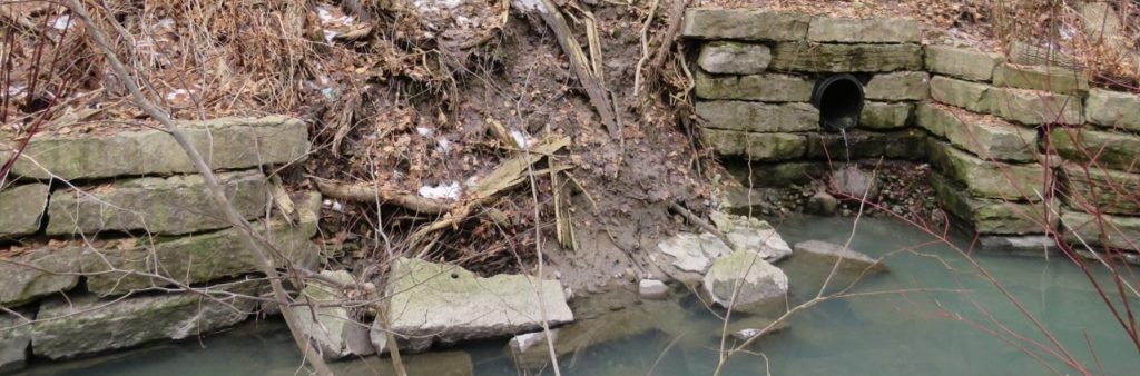
The geomorphology of a stream examines how natural and human factors have shaped its form and function over time. Erosion can affect the path a stream follows (form) and the aquatic and terrestrial habitats the stream supports (function). Erosion results in gradual changes to the form and function of the stream and stream bed. Significant changes to water levels contribute to increased erosion.
During storm events, rain water or snow melt runoff enters underground pipes via drains and catch basins on streets and in parks and is discharged from storm sewer outfalls into watercourses that flow to Lake Ontario. At times these flows can be high, resulting in erosion damage. High flows from past storms have caused substantial erosion damage to sewers and watermains located in and near the City’s ravines and watercourses.
This erosion damage can:
To learn more about erosion in streams and rivers, view the Understanding Streams information deck.
The map below shows the location of Yellow Creek and the study area.
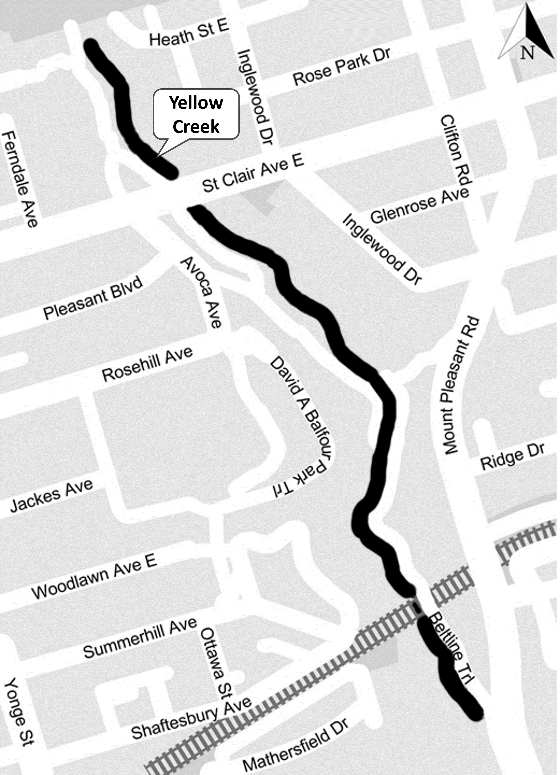
The study area is the 1.3 km above ground length of Yellow Creek from north of St. Clair Avenue to the southern part of David A. Balfour Park, south of Summerhill Avenue near Mount Pleasant Road.
While we aim to provide fully accessible content, there is no text alternative available for some of the content on this page. If you require alternate formats or need assistance understanding our maps, drawings or any other content, please contact us at 416-338-2985 or email yellowcreek@toronto.ca.
The purpose of the study is to develop a Geomorphic Systems Master Plan (GSMP) for Yellow Creek that will include recommendations for stabilizing the creek and protecting water infrastructure from erosion. Through the study, the City:
The study did not examine trail conditions or recommend improvements to trails, forestry or ravine amenities.
The study was carried out following the requirements of the Municipal Class Environmental Assessment (MCEA) Master Planning process, where the level of investigation, consultation and documentation are sufficient to fulfill the requirements for Schedule B projects identified within the Master Plan.
Steps in the MCEA study process
Following a successful review period the Master Plan will be complete. Projects identified within the Master Plan may proceed to detailed design and implementation and will be included in the City’s stream restoration and erosion control program. Implementation will be prioritized across all GSMPs city-wide.
The Master Plan report is shared with the City’s Parks, Forestry and Recreation division and TRCA for coordination and collaboration to advance a long-range plan for Yellow Creek.
The Master Plan for Yellow Creek includes projects that are projected to be carried out in the medium term (5-10 years) and long term (beyond 10 years).
The decision for when long term projects are addressed will be assessed using several factors including a monitoring program of the existing erosion control structures, which, overall, are currently in a reasonable state of repair.
The City will issue future notification prior to any construction.
In Yellow Creek there are 10 City of Toronto water infrastructure sites at risk of erosion:
The level of erosion risk has been assessed at each site:
Low-Risk Sites
Moderate-Risk Sites
High-Moderate-Risk Sites
High-Risk Sites
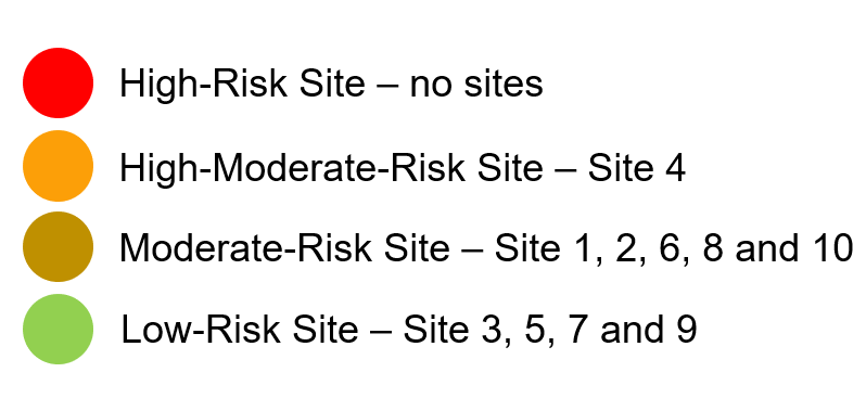
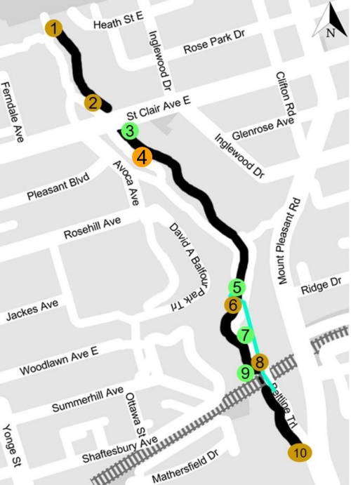
Map image of infrastructure sites.There are no high-risk sites for water infrastructure in Yellow Creek.
The following alternative solutions for natural channel design were evaluated for the infrastructure sites at risk of erosion in the study area:
Alternative 1: Do nothing (no planned interventions, only ongoing monitoring)
Alternative 2: Improvements through local works less than 100 metres
Alternative 3: Improvements to a segment of the creek greater than 100 metres
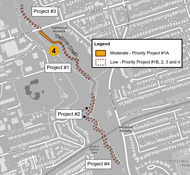
Based on a risk assessment of the water infrastructure sites, and following a detailed evaluation of the alternative solutions, the City is recommending four projects to stabilize the creek bed and banks of the creek through natural channel design. All four recommended projects would involve improvements to a segment of the creek greater than 100 metres (Alternative 3).
Of the infrastructure sites, one infrastructure site has been identified as moderate-high risk of damage from erosion. A portion of Project #1, which addresses the higher-risk Site 4, will be prioritized over other recommended projects for Yellow Creek.
For more detail on the project recommendations, go to the Public Consultation heading below to participate in the Virtual Meeting on November 27, 2023 or view the Virtual Public Meeting presentation deck.
Future implementation of the recommended projects will require tree and vegetation removal, followed by native species replanting. A restoration plan will be developed prior to construction as part of a future design phase after the study.
While we aim to provide fully accessible content, there is no text alternative available for some of the content on this page. If you require alternate formats or need assistance understanding our maps, drawings or any other content, please contact us at 416-338-2985 or yellowcreek@toronto.ca.
The study was carried out following the requirements for Master Plans under the Municipal Class Environmental Assessment process. A copy of the study report was made available for public review in 2025. See the Yellow Creek Notice of Completion for details.
While we aim to provide fully accessible content, there is no text alternative available for the report appendices. If you require alternate formats or need assistance understanding maps, drawings or any other content, please contact us at 416-338-2985 or yellowcreek@toronto.ca.
A virtual public meeting was held on November 27, 2023. Members of the public were provided with an overview of the study, had the opportunity to review recommended solutions, ask questions and provide feedback.