Building on the work of Eglinton Connects, Don Mills Crossing will look to improve connections to the surrounding areas, lay out a network of open space and identify community services necessary to support new growth. This a key city building moment for Don Mills & Eglinton.
The evolution of the Don Mills and Eglinton area has always been closely tied to transportation infrastructure. The transit infrastructure being constructed as part of the Crosstown LRT will trigger the next wave of city building in the area. The new LRT stop and the bus terminal are anticipated to generate new development interest in the area, creating community building opportunities.
Don Mills Crossing will result in an updated planning framework, which may include implementation measures such as as Official Plan Amendments and Zoning supported by urban design guidelines, transportation and servicing master plans to support continued employment and residential investment and intensification, and related community infrastructure.
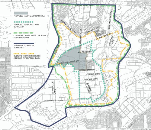
The Core Study Area integrates the three corners of Don Mills Road and Eglinton Avenue East identified as a Focus Area by Eglinton Connects with the CelestIca lands to the northwest of the intersection. At approximately 24 hectares (60 acres), the Celestica lands are one of the largest private redevelopment sites in Toronto. The other three corners of Eglinton Avenue East and Don Mills Road consist of lands primarily in public ownership, including City-owned land under the jurisdiction of Build Toronto. The combination of these two factors allows for the consideration of a number of options to deliver a new public realm, a connected open space system, community facilities, employment uses, affordable housing and sustainable development. It is anticipated that the planning framework which will emerge through Don Mills Crossing will be focused on this Core Study Area.
Beyond the Core Study Area, larger areas of influence are also being studied related to the following city building matters:
The technology to convert the map on this page to an accessible format is not currently available. The map may not be compatible with screen reader software. If you are unable to access these maps please contact Christian Ventresca, Strategic Initiatives, City Planning, Christian.Ventresca@toronto.ca, 416-392-3439.
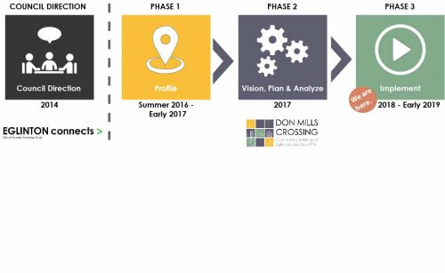
Don Mills Crossing has three key stages, with public consultation at each stage. The Study will take approximately two years to complete.