The Golden Mile area currently consists of large-format retail buildings and surface parking with low-rise commercial and industrial buildings to the north and south of Eglinton Avenue East.
The Study included:
a vision and planning framework for the Golden Mile;
additional policies to the City’s Official Plan;
Urban Design Guidelines;
a Transportation Master Plan;
a Master Servicing Plan;
a Community Infrastructure Strategy;
a Parks and Open Space Strategy, and
built form, streetscape, pedestrian, cycling and public art strategies.
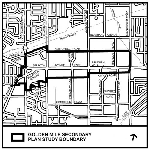
Study Area
The study area is generally bounded by Victoria Park Avenue to the west, Ashtonbee Road/Hydro Corridor to the north, Birchmount Road to the east, and an irregular boundary to the south. The study area is approximately 113 hectares (280 acres) in size.
Map showing boundaries of the Golden Mile Secondary Plan Study area
Scheduling & Phasing
The Golden Mile Secondary Plan Study consisted of three phases and is complete.
Phase 1:
May – Dec 2017
Background
Analysis
Community Consultation
Visioning
Phase 2:
Jan – Aug 2018
Design Analysis
Testing of Alternatives
Community Consultation
Phase 3:
Sept 2018 – Early 2019
Final Design and Plan Development
Design Review Panel
Community Consultation
Final Consultant Report
Final City Staff Report
Statutory Public Meeting – Scarborough Community Council
City Council (early 2019)
Background
As recommended in the Eglinton Connects Planning Study, City Planning staff have initiated a Secondary Plan Study for the Golden Mile area.
The Golden Mile Secondary Plan Study will facilitate and support appropriate residential and non-residential growth within the Mixed Use Areas designation, while protecting and encouraging new employment and office development and investment within the Employment Areasdesignation.
The study will also:
review the potential of the area comprised wholly of an Apartment Neighbourhoodsdesignation;
address the potential issue of land use compatibility and the addition of amenities throughout the area to create an attractive environment and complete community for the existing and future working and resident populations; and
examine the lands designated Parks and Other Open Space Areas and identify any future parks needs.
To assist with the study, the City has hired the consulting firm of SvN Architects + Planners, Inc. who are leading a team of professionals in land use planning, urban design, transportation, servicing, community services and public engagement.