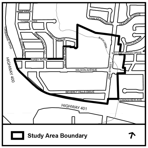
The purpose of the study is to create a vision, goals and principles to guide future growth and redevelopment on Wilson Avenue, between Highway 400 and Jane Street. The study focuses on:
The study area is characterized by a mix of retail, residential and employment uses.
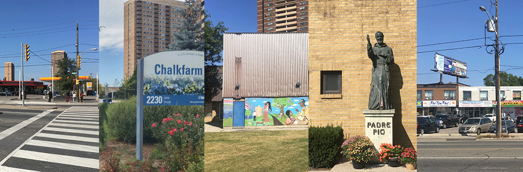
The study area is also characterized by a variety of building types reflecting their various uses. Sheridan Mall and other retail/commercial buildings with large vehicular surface parking areas occupy the north side of the Avenue. In addition, walk-up apartment buildings also occupy the north side of the Avenue. The south side of the Avenue is occupied by a commercial strip plaza, Toronto Plaza Hotel, a place of worship, a park/open space, and a variety of stand-alone retail/commercial buildings with vehicular surface parking areas fronting on the Avenue.
The lands south of the properties fronting Wilson Avenue along Beverly Hills Drive include an open space, a place of worship, a Catholic Secondary School, a Seneca College campus, a funeral home, an entertainment establishment, a bakery and a vehicular surface parking area behind Toronto Plaza Hotel.
The portion of Wilson Avenue between Jane Street and Daliner Road is characterized by narrow sidewalks adjacent to a vehicular surface parking area, limited street furniture and the absence of soft landscaping, particularly in the areas occupied by commercial uses. The portion of Wilson Avenue between Daliner Road and Highway 400 has soft landscaping with trees on private and public property.
Chalkfarm Park, the Black Creek, a Toronto Fire Services Station and a commercial plaza are located on the west side of Jane Street, north of Wilson Avenue. On the east side of Jane Street, an apartment neighbourhood, a commercial plaza, Heathrow Park and a neighbourhood with low-scale buildings are located further east. Strip commercial plazas, an office building and a cluster of apartment buildings with Natural Areas (open space) are located in the southeast quadrant of Jane Street and Wilson Avenue.
The study area is located in an area identified as a Neighbourhood Improvement Area in the City of Toronto. Neighbourhood Improvement Areas are recognized neighbourhoods in the City that have inequities in a number of key areas of well-being, namely, Economic Opportunities, Social Development, Healthy Lives, Participation in Decision-Making and Physical Surroundings.
A portion of Wilson Avenue in the study area is identified as an Avenue in the Official Plan. Avenues are important corridors along major streets where reurbanization is anticipated and encouraged to create new housing and job opportunities, while improving the pedestrian environment, the look of the street, shopping opportunities and transit service for community residents.
The study area along Wilson Avenue is designated Mixed Use Areas and General Employment Areas in the City’s Official Plan, which are areas that will absorb most of the anticipated increase in retail, office and service employment in Toronto in the coming decades, as well as much of the new housing. The lands in the study area along Jane Street are designated Apartment Neighbourhoods, Mixed Use Areas and Natural Areas. Apartment Neighbourhoods are stable areas that were not expected to experience significant growth, but, where compatible infill development may be permitted on underutilized sites that contain apartments. Natural Areas are to be maintained primarily in a natural state whereas Mixed Use Areas, as noted above is a land use designation that supports growth.
The study area is located in the Jane-Wilson: Black Creek Special Policy Area in the City’s Official Plan. Special Policy Areas were established by the province to recognize historic development areas that were within a floodplain, where strict adherence to floodplain regulations would not allow these areas to remain viable. Many historic downtowns in Ontario were at least partially located within a floodplain, as locational requirements drew them to situate in proximity to watercourses and waterbodies. The community located at Jane and Wilson was established in the floodplain of the Black Creek. Any development within the Special Policy Area must be designed to withstand a flood event.
Toronto’s Official Plan sets out the vision for where and how the City will grow to the year 2051. The Official Plan describes the general location for new housing, employment, office and retail areas, community services, parks and other land uses. The Official Plan also establishes policies for the built environment such as criteria for how new buildings relate to the street, for improvements to the City’s hard services (such as transit, roads and sewers) and for the protection of the City’s natural and built environment.