This is an archival photograph from 1932 showing the intersection of Augusta Avenue and Baldwin Street
Augusta Avenue looking east to Baldwin, 1932. City of Toronto Archives.

The Kensington Market Heritage Conservation District (HCD) Study was prioritized by City Council in March 2015. The purpose of the HCD Study was to provide an overall understanding of the area’s history and heritage character and to determine if an HCD would be an appropriate heritage planning tool for the area.

The City of Toronto’s City Planning Division initiated the Kensington Market HCD Study in Spring 2016, engaging a consultant team led by Taylor Hazell Architects to conduct the study. The HCD Study report was endorsed by the Toronto Preservation Board in September 2017 with the recommendation to proceed with developing an HCD Plan for the Kensington Market HCD.

The Kensington Market HCD Plan will include policies and guidelines to conserve the cultural heritage value and heritage attributes of the neighbourhood.
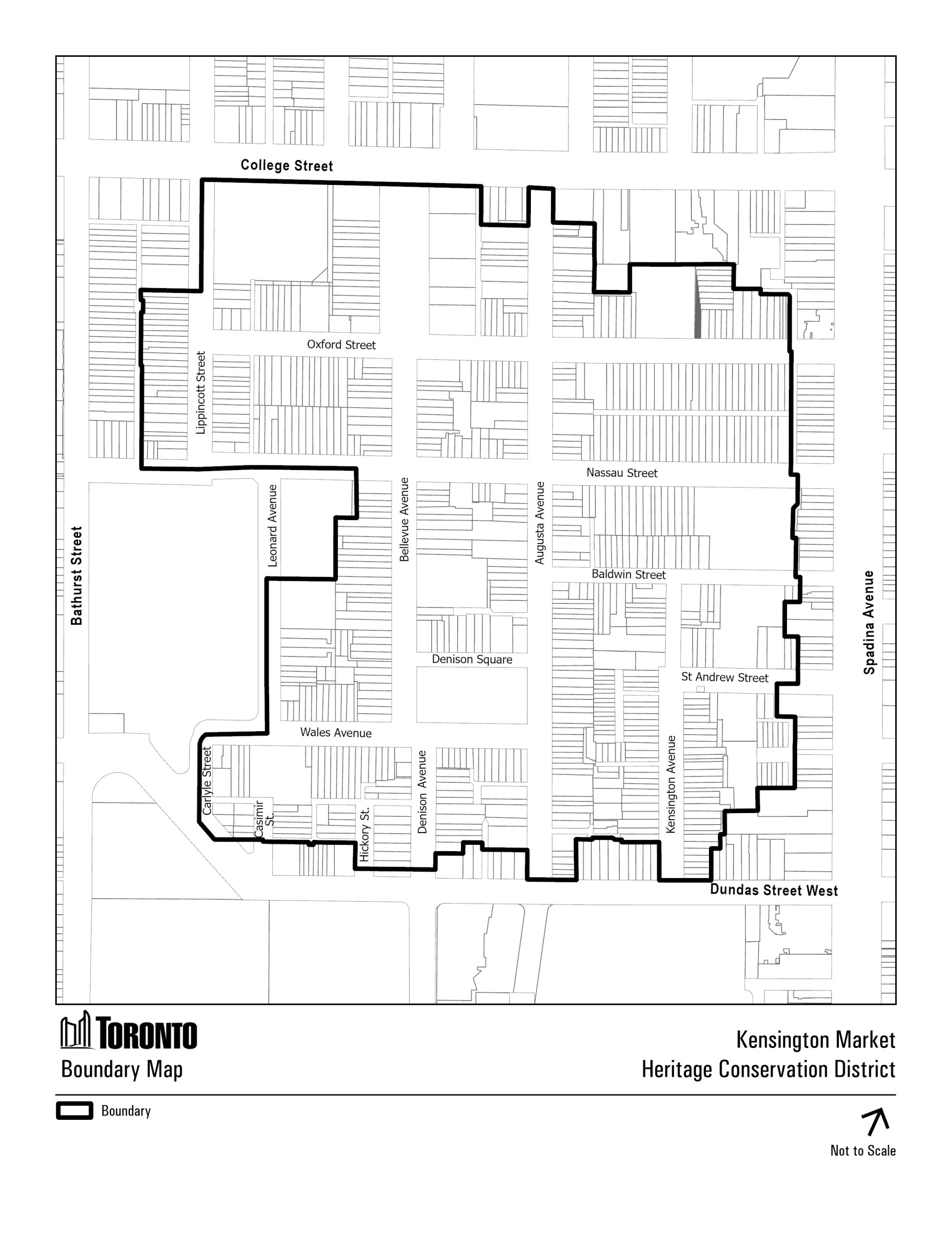
 The process includes two public meetings, as well as the convening of a community advisory group to provide specific and detailed feedback on policy directions and recommendations.

The following Statement of District Significance has been prepared for the Kensington Market Heritage Conservation District. The statement may change through the course of preparing the HCD Plan:

The Kensington Market Neighbourhood Heritage Conservation District is of cultural heritage value for its historical associations with immigration and commercial activity, design value for its collection of vernacular buildings many of which have been modified and for its unique street and block layout, and social value for its active and activist community who engage in a variety of events – commercial, artistic, social and political. The consultant team also identifies the district as a landmark, known to Torontonians and visitors alike.

Description of Historic Place

The Kensington Market Neighbourhood Heritage Conservation District is bounded by Dundas Street West to the south, Spadina Avenue to the east, College Street to the north and Bathurst Street, Leonard Avenue and Carlyle Street to the west. It encompasses approximately 35 hectares (88 acres) containing 868 properties. It is a mixed-use area with residential properties generally located in the western portion of the Study Area and retail business in the eastern portion.

Historical and Associative Values

The district’s historical value resides in its direct association with the theme of immigration in Toronto from the mid 19th-century to today. Attracted by affordable housing and proximity to employment, successive waves of immigrants have found a home and supportive community in Kensington.

From the 1870s through the earlier 1900s, the district developed as a suburban residential neighbourhood inhabited primarily by immigrants from the British Isles and their descendants. In the 1910s large numbers of Jewish immigrants moved to the area, many from other parts of the city. They recreated a shtetl environment in the district, in part by modifying residential buildings to permit commercial uses. Many Jewish residents converted the single family dwellings into multi-unit apartments or lodging houses. The Jewish Market emerged along Kensington Avenue and Baldwin Street and was known for its chaotic nature and open air display of goods on lawns, doorsteps and curbs. Many merchants lived above their shops, or a short walk away.

Following World War II, large groups of immigrants from Hungary (1940s-1950s) and Portugal (1950s-1960s) settled in the district. Portuguese settlement in the area was characterized by the commercialization of Augusta Avenue, by way of new construction and alterations to existing residences. The market became a centre for overseas importing, a factor which continued to draw immigrant groups to the district.

Subsequent immigrant groups include Chinese, Vietnamese and Korean immigrants (1960s-1980s); Latin American, Southeast Asian, African and Jamaican immigrants (1990s-present). They set up specialized businesses often with goods imported from their native countries and thus targeting to their ethno-cultural group.

Each group has left its collective mark on the district and added to the layers of cultural diversity and vibrant street life through their customs, religious and spiritual practices. The community’s diversity is also reflected in the numerous grass-roots and not-for-profit organizations that provide social services and are responsible for events and festivals throughout the year.

Design and Physical Values

The district’s design value results in part from Toronto’s Park Lot system, which permitted property owners to subdivide their properties and create streets to suit their own circumstances. Within the Kensington Neighbourhood HCD, three different individuals, each owning a different portion of the district, subdivided their holdings with little regard for the block patterns and right-of-ways created by their neighbours. William Warren Baldwin was the first, creating Spadina Avenue and subdividing his holdings in the 1820s to squat blocks, consistent in size with those from the Town of York in the 1820s. George Taylor Denison began subdividing in the 1850s, beginning with the lands furthest away from his Bellevue Estate. Owing to poor sales, these same lands were re-subdivided in the 1860s, followed by most of the lands associated with the estate itself. George Crookshank began selling his northern holdings in the district in the 1850s, as part of a speculative subdivision that stretched much further west and north.

This uncoordinated and piecemeal pattern of subdivision over the course of half a century created a unique street and block pattern with no two blocks of the same size, and just as many oriented east-west as north-south. It created the north-south and east-west streets of the district, many of which did not align with those of neighbouring parcels, and only two of which continued outside the district. The unique street and block pattern of the district creates a discrete neighbourhood, disconnected from the grid and cross-streets of the broader urban fabric. This physical separation made the district a suitable place for immigrant and minority groups seeking to establish and practice their own culture.

The district evolved into a residential working class area in the late-1880s. The subdivision and subsequent development of semi-detached and row housing stock created narrow property frontages and laneways that characterize much of the neighbourhood. Upon conversion to retail, narrow frontages provided the basis for the district’s fine grain commercial space, whose affordability made them amenable to immigrant and minority communities. The continued existence of these narrow frontages are a defining characteristic of the district.

Some of the district’s awkward and oversized building lots proved an inefficient use of land. Many of these were re-subdivided, with smaller housing being shoe-horned into the extra spaces off the city streets. These collections of laneway housing were developed in groups, (as in the ‘Terraces’ and ‘Places’), and individually, are an important feature of the district.

Housing in the district reflected contemporary styles (Ontario Cottage and Bay-n-Gable) and forms (detached, semi-detached and rows), generally ranging from one to two-and a-half storeys in height. These modest two-storey wood structures were gradually modified by successive generations and new immigrants.

The first wave of modifications were undertaken by Jewish immigrants beginning around 1910 when houses along Kensington Avenue, St. Andrew Street and Baldwin Street were transformed into mixed use buildings with retail establishments on the ground floor and residential above – most often occupied by the business owner. Subsequently, Portuguese immigrants modified properties along Augusta Avenue during the post-World War II era. The concentration of these houses with commercial façade additions within a residential neighbourhood is rare in the city.

Residential buildings also demonstrate an incremental evolution reflecting the district’s layered history of inhabitants. Alterations to houses typically include wrought iron porches replacing their wooden precedents, and façades re-painted, re-cladded, or entirely reconfigured.

Two of the district’s bounding avenues, College Street and Spadina Avenue, were developed as major commercial streets. They are characterized by bold commercial buildings and historically contained social and recreational spaces serving the surrounding neighbourhoods. They contain excellent examples of Renaissance Revival architecture in commercial rows.

Contextual Values

The built resources in the district, as a layered neighbourhood of altered structures set within current and former residential streets, are tied to the history of the district as a place reworked by successive generations of ethnic and social outsiders. In the 1910s the district’s new Jewish community activated the interior streets of the neighbourhood by integrating commercial ventures into residential dwellings. Successive immigrant and social groups have maintained this agency over the built form, continuing to alter the forms and uses of structures to suit their needs and rituals.

The district is known for its distinctly vibrant, colourful, and chaotic character. This is tied to, and supported by the area’s history as an alternative market space, established and sustained by various minority groups. As a social enclave and market space, the district has long supported diverse and alternative cultural expressions and practices. These began with Jewish market in the 1910s, when methods of buying, selling, and displaying goods stood in stark contrast to those of other markets and commercial areas of Toronto. Later, additional ethnic and social groups settled in the district, whose diverse expressions and practices added to this mosaic and legacy.

The district is amongst Toronto’s most widely known neighbourhoods to locals and visitors alike. Both the physical neighbourhood, and the idea of ‘Kensington Market’ are considered landmarks.

Social and Community Values

Stemming from its history as an immigrant neighbourhood, the district supports the resilient nature of its community, a trait seen in its novel combination of dynamism and stability. Its ability to absorb changes in built form and demographics without disrupting a core identity is an important historic and ongoing characteristic of the neighbourhood.

Stemming from its history as a space for successive groups of social outsiders, the district is a constantly evolving canvas for public art and expression. These expressions are readily observed in both the public and private realms.

As an area with a history of supporting minority communities, the district has developed a local culture that is both active and activist. Many citizens are highly active in local social, political and commercial matters, an ongoing value that continues to shape the community.

Similarly there is a legacy of institutions serving as support networks, and the district supports numerous organizations and institutions many of which are grassroots and not-for-profit. The district also supports numerous events and festivals, a value tied to its tendency towards activism, community and expression.

The Kensington Market HCD Study Area is bound by College Street to the north, Spadina Avenue to the east, Dundas Street West to the south and Bathurst Street to the west. The Study Area may change through the Study process, and does not necessarily reflect the final HCD boundary.


This is a map showing the proposed boundary for the Kensington Market HCD Plan

The Kensington Market HCD Study was initiated in Spring 2016, and the HCD Study report was endorsed by the Toronto Preservation Board in September 2017 with a recommendation to proceed with developing an HCD Plan for the Kensington Market Neighbourhood HCD.

Once complete, the HCD Plan for the Kensington Market Neighbourhood will be presented to the Toronto Preservation Board, Toronto East York Community Council and City Council for their consideration.