The purpose of this study is to assess the compatibility of established employment uses with the array of use permissions that exist through the current in-force zoning by-law and with the adjacent residential area. The study will review and assess the opportunity for conversion of employment lands through the redesignation of lands to uses that are more compatible with the existing surrounding residential character and the introduction of residential uses.
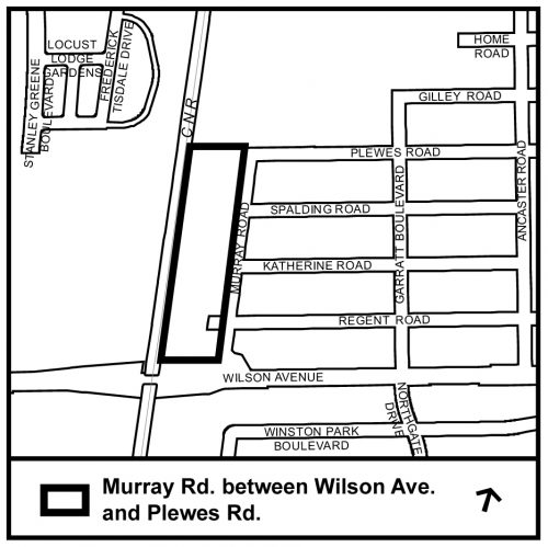
The Murray Road study area is bounded by Wilson Avenue to the south, Murray Road to the east, Plewes Road and the City Transportation Yard to the north and the railway corridor to the west. The lands are located within Ward 9.
Please contact us if you have any questions, comments or concerns about the study.
Currently there is one planning application within the study area.
In order to facilitate a review of the existing land use permissions and regulations within the Murray Road Study Area and to determine if new Official Plan polices and Zoning standards are required to regulate land use in the area, City Council passed an Interim Control By-law No. 71-2016 on February 3 and 4, 2016 (File # 16 115948 NNY 09 OZ) for a period of one year, expiring February 3, 2017.
The Interim Control By-law No. 71-2016 was amended by By-law 115-2017 amend the Interim Control By-law expiry date at the January 31, 2017 City Council meeting (File # 16 115948 NNY 09 OZ). The Interim Control By-law will now expire on February 3, 2018.
Toronto’s official Plan sets out the vision for where and how the City will grow to the year 2031. The vision of the Plan is about creating an attractive and safe City that evokes pride, passion and a sense of belonging – a City where people of all ages and abilities can enjoy a good equality of life. A City with:
The Official Plan is a blueprint. It describes the general location for new housing, employment, office and retail areas, community services, parks and other land uses. The Official Plan also establishes policies for the built environment such as criteria for how new buildings relate to the street, for improvements to the City’s hard services (such as transit, roads, sewers) and for the protection of the City’s natural and built environment.
This review looked specifically at the City’s designated areas of employment and how the Official Plan polices and designations are working. The Provincial Growth Plan requires the City to address specific criteria if it wants to consider changing the land use permissions for designated areas of employment. Since the City’s 5 Year review of the Official Plan includes a review of policies and designations for employment lands, it was an appropriate opportunity to undertake the Municipal Comprehensive review at the same time.
A preliminary assessment based on the criteria of the Growth Plan and the Provincial Policy Statement determined that the lands as shown on the study area map could be converted through re-designation to regeneration Areas, but only through the creation of a site and area specific policy or secondary plan to address Section 4.7 of the Official Plan.
The effect of the new Official Plan policies were to create new Official Plan designations for Employment Areas that would preserve employment lands for future job growth, limit sensitive uses in employment areas and promote maintenance and growth of office and jobs on rapid transit. Official Plan Amendment #231 to the Official Plan for the City of Toronto also re-designated the proposed Murray Road Land Use Study lands as a Regeneration Area.
The current Employment Areas land use designation provides for a variety of employment related uses, whereas the Regeneration Areas designation provides for a broad mix of uses which could include residential.