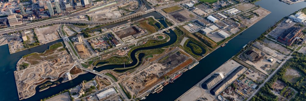
Toronto’s Port Lands is an area of about 356 hectares (880 acres) that stretches from the Inner Harbour on the west to Leslie Street in the east, and from Lake Shore Boulevard in the north to the to the Outer Harbour in the south.
The Port Lands were created in the early 20th Century by filling in Ashbridges Bay to create additional industrial areas for the growing city. Prior to this, the area was the largest marsh on Lake Ontario – a fertile wetland, fishing ground and important gathering place for Indigenous peoples who lived and travelled in the region. Today, the lands continue to be used for industrial and port functions, but there are large amounts of vacant and underutilized land. The Port Lands are an unparalleled revitalization opportunity for Toronto.
Not only is the Port Lands one of the most significant urban renewal opportunities in Toronto, it is also a remarkable place today. Its concentration of heritage resources, natural areas, active port and industrial uses assist in building and maintaining the broader city. It also has numerous film studios and related uses that support Toronto’s film sector. Several planning initiatives are underway setting the stage for urban renewal.
The Port Lands Planning Framework (PLPF), Port Lands Official Plan Modification (OPM) and Ookwemin Minising Precinct Plan (formerly known as Villiers Island) were adopted by City Council on December 8, 2017. These studies and the implementing OPM represents the culmination of over four years of collaborative work by the City and Waterfront Toronto, with support from the Toronto and Region Conservation Authority and numerous City divisions and agencies, reflecting a robust consultation and engagement program. These documents provide guidance on urban renewal within the Port Lands and ensure all development advanced in the near, medium and longer-terms will support long-term city building objectives.
The Port Lands Planning Framework, approved by City Council in December 2017, provides:
While the Port Lands Planning Framework is a major accomplishment for advancing more detailed planning in the area, additional studies and work continues to be advanced to implement this vision.
The December 5, 2017 Council Decision on the Port Lands Planning Initiatives – Final Report, approved:
Several appellants of the Central Waterfront Secondary Plan (CWSP), including public agencies, existing industries, and private owners with development aspirations, raised issues with Port Lands Official Plan Modification (OPM).
The Port Lands OPM was appealed to the Ontario Land Tribunal (OLT) and the City worked with the various appellants to resolve the majority of issues. A Settlement Hearing was held on April 16, 2021 to present the various settlements and the revised version of the OPM to the Tribunal.
The Phase 1 OLT Decision on May 18, 2021, resolved land use, land use and land use compatibility issues.
A Port Lands OPM Phase 2 OLT Settlement Hearing was held on May 19, 2022 which presented revisions to the Port Lands OPM that resolved the majority of outstanding matters, specifically cultural heritage, views, inclusive communities, community infrastructure, built form, arts and culture, sustainability and biodiversity. The Phase 2 OLT Decision was issued on July 11, 2022.
Access the September 25, 2025 consolidated version of the Former City of Toronto Official Plan Central Waterfront Secondary Plan, including the Port Lands Area Specific Policy, as amended by Ontario Land Tribunal Decisions. The City of Toronto Official Plan version of the Central Waterfront Secondary Plan, which is not in force for the Port Lands but for much of the Central Waterfront, can be located in the Official Plan: Chapter 6 Secondary Plans.
Please contact Erika Ivanic, Project Manager, Waterfront for a copy of the Phase 2 OLT Decision.
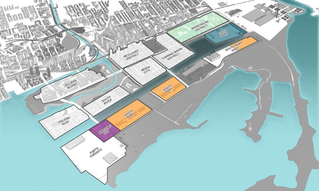
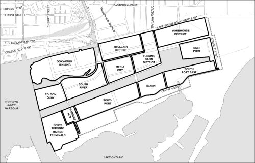
The Port Lands Planning Framework provides direction with respect to commercial, industrial and park land uses that will be encouraged within the Port Lands. The current zoning does not permit many of these uses within the Port Lands. New zoning regulations for employment-focused districts better align with the Council-adopted Port Lands Planning Framework direction, and are more reflective of land uses that the City is encouraging in the Warehouse District, East Port, South Port and Maritime Hub.
In particular, the zoning review updated zoning for Port Lands employment- focused lands, and increase as-of-right zoning permissions for port, industrial, and production, interactive and creative uses.
In addition, the zoning review addressed parks and open system to ensure it aligns with the Port Land Planning Framework’s land use direction.
City staff were directed by City Council to update the zoning for approximately 200 hectares of employment lands to facilitate the transformation of the Port Lands into a number of new urban employment districts amid activities of a working port that include Media City, Turn Basin, Warehouse, East Port and South Ship Channel Districts.
The four adopted zoning by-law amendments to Zoning By-law 569-2013 can be found at:
The four Port Lands Zoning Review By-laws were appealed to the Ontario Land Tribunal (OLT) and are not in force for the Port Lands. An OLT Hearing has not been scheduled at this time.
Due to the appeals to the Port Lands Zoning Review zoning by-laws, Zoning By-law 438-86 remains in force, as well as the Port Lands Interim Control By-law.
The City of Toronto, in partnership with Waterfront Toronto, is undertaking an urban design guidelines study for Production, Interactive and Creative (PIC) districts to further expand on the Council-adopted vision for the Port Lands for approximately 33 hectares of industrial land. This area will transform into two vibrant modern, urban districts that will become a creative industry hub, anchored by film and media campuses.
Media City and the Turning Basin are Production, Interactive and Creative (PIC) Core Districts in the Port Lands that employment-focused with vibrant pedestrian-friendly streetscapes and water’s edge promenade.
Media City is envisioned as a district for film, television and digital media production alongside other creative and supportive uses. Turning Basin will transition from light manufacturing and warehousing into creative uses.
Stakeholder involvement and public consultation are critical components of the urban design guidelines study. The City is holding a Community Consultation meeting to present an update on the direction of the PIC Core Urban Design Guidelines Study, and provide an opportunity for your questions and to share your comments.
Virtual Public Open House #1
This public open house was held on September 22, 2022 and focused on providing an update on the PIC Core Urban Design Guidelines and an opportunity for community members to provide input into the guidelines.
The Waterfront Toronto PIC Core Urban Design Guidelines website includes information on the Virtual Public Open House, including the Virtual Open House Presentation material and a video of the Virtual Public Open House.
LURA Consulting prepared a Summary Report of PIC Core Public Engagement for the first round of public and stakeholder engagement.
Please contact Anthony Kittel, Project Manager, Waterfront for a copy of the Summary Report of PIC Core Public Engagement.
The Port Lands Planning Framework and the Port Lands Official Plan Modification, adopted by City Council on December 5, 2017, provides detailed land use directions for the Regeneration Areas in the Central Waterfront Secondary Plan and endorsement of a work program to initiative more detailed planning in key areas of the Port Lands.
City staff were directed by City Council to develop production, interactive and creative core urban design guidelines for the Media City and Turning Basin Districts to provide guidance on performance standards and inform the Port Lands Zoning Review Study.
February 3, 2020 Film, Television and Digital Media Advisory Board:
January 26, 2022 Waterfront Design Review Panel Meeting:
April 4, 2022 Film, Television and Digital Media Advisory Board: (NEW)
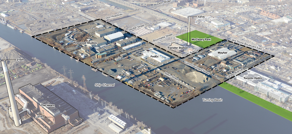
McCleary District comprises approximately 20 hectares (49 acres). It’s bounded by Don Roadway to the west, Commissioners Street to the south, Lake Shore Boulevard East to the north, and Logan Avenue to the east.
McCleary District is envisioned as a dense, transit-oriented, complete mixed-use community and an active hub. The District will contribute to broader economic objectives and complement the East Harbour office destination envisioned to the north. It will also complement the film studios and other creative spaces to the south and east. The District will be bookended by two spectacular open spaces – the new Don River Valley to its west and McCleary Park to its east.
CreateTO is leading a precinct planning process in partnership with the City and Waterfront Toronto. The McCleary District Precinct Plan will provide more detailed direction for the District, building on the Port Lands Planning Framework and Central Waterfront Secondary Plan (CWSP). The CWSP required that a precinct plan be completed before rezoning these lands with residential permissions.
The precinct plan will establish local street and block patterns, locally-oriented parks and open spaces, the preferred location for community infrastructure, detailed urban design and streetscape guidelines, heritage, passive design, and sustainability recommendations, and specific strategies for public art and affordable housing.
The next phases of work will commence in 2026 including a massing study, public realm plan and ongoing infrastructure coordination. In the interim, a suite of Meanwhile Use are being advanced as the sites gradually build out (2025-2050). “Meanwhile Uses” refer to a planning and zoning approach that allows for temporary non-residential uses and activities to occupy land or buildings that are vacant, underused, or awaiting permanent, long-term development. This strategy is designed to activate spaces during the period before full build-out occurs. The draft Official Plan Amendment enables this approach through the McCleary District Meanwhile Uses - City-Initiated Draft Official Planning Amendment.

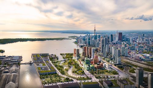
The City of Toronto, together with CreateTO and Waterfront Toronto, is advancing a significant revitalization project for the Port Lands which will unlock 240 hectares of land for redevelopment. The Port Lands is being transformed into a dynamic, inclusive mixed-use community, with housing at all levels of affordability combined with supportive community infrastructure. It will also continue as an employment hub, bolstering the City’s film, television, and creative sectors, alongside sustained port and industrial activities.
At the heart of this redevelopment is a new Island, Ookwemin Minising, which will be the first mixed-use residential community emerging through this transformation; defined by the renaturalized Don River it will develop into a sustainable and complete community. On November 1, 2024, an Indigenous Advisory Circle announced the name Ookwemin Minising, for the new island formed in the Port Lands. City Council adopted the name, changing the name of the Precinct from Villiers Island to Ookwemin Minising [Oh-kway-min Min-nih-sing], meaning “place of the black cherry trees”.
Ookwemin Minising is part of Toronto’s broader waterfront revitalization, building on two decades of a successful tri-government collaboration. This model has spurred long-term economic growth and prosperity by flood protecting and remediating contaminated land, and developing both market and affordable housing. Waterfront revitalization has also delivered award-winning parks, public spaces, and architectural advancements, all while setting higher standards in sustainable development. This approach attracts innovation-focused companies and enhances the waterfront’s appeal as a destination for both Toronto residents and visitors.
In June 2024, City Council approved an update to the Ookwemin Minising Precinct Plan (formerly known as Villiers Island) to permit more than 9,000 homes and 15,000 residents, supported by local retail, new parks, childcare, a library, a community centre, and a street network with space for generous sidewalks, plantings, cycle tracks, and transit. Ookwemin Minising is part of the larger Port Lands area, which is projected to be home to nearly 40,000 people and 30,000 jobs in the future.
It will also be a waterfront destination – its infrastructure and amenities will serve a local population and be a regional attraction.
Over nearly two decades, engagement has shaped the Don Mouth Naturalization and Port Lands Flood Protection Project Environmental Assessment, Port Lands planning, and precinct planning.
Over the past 18 months, the City of Toronto, CreateTO and Waterfront Toronto have studied options to increase density on the Island. This has been supported by extensive public engagement:
In March 2023, targeted stakeholder meetings were held to prepare for public engagement. Stakeholders, grouped by interest areas, discussed the relevance of the 2017 guiding principles and potential changes.
On June 19, 2023, over 200 people attended a virtual public meeting, followed by 747 survey responses.
The panel reviewed density increase options and commented on the need for higher density, increased affordable housing, detailed public realm designs and transit capacity information.
A virtual public meeting on March 26, 2024, showcased the outcomes of the density study. Approximately 325 attendees heard a report back on the emerging precinct plan update for the Island, including the proposed changes to built form and future opportunities to provide input as design advances on the public realm. A video recording of the meeting is available.
The panel reviewed the density study and massing demonstration plan, emphasizing the need for a 21st-century neighborhood, detailed mid-block connections, flexible zoning, and pedestrian-friendly streets.
An in-person open house held on May 2, 2024, showed similar information to the virtual meeting held in March 2024. Approximately 175 attendees expressed support for the density increase and the overall built form approach, showing excitement about new park spaces and recreational activities.
Continuous engagement with landowners, port industries, PortsToronto, school boards, and community service providers occurred over the last 18 months to review density options, due diligence findings and suggestions for refining the density approach.
For more information on the meeting materials and comments received, please visit Public Information Centres – Waterfront Toronto.
City staff, Waterfront Toronto and CreateTO were directed by City Council to update the Ookwemin Minising Precinct Plan (formerly known as Villiers Island), with a focus on increasing densities to provide more affordable housing while retaining the vision, principles and character of this new community.
To learn more about engagement opportunities and activations on Ookwemin Minising, visit: Ookwemin Minising | Waterfront Toronto
The Ookwemin Minising Official Plan Amendment and Zoning By-law Amendment was appealed to the Ontario Land Tribunal. The City is working with the appellants on the resolution of the identified issues.
The Ookwemin Minising appeals have been assigned the Ontario Land Tribunal Case Number OLT-24-000835. For updates on the progress of the appeal process, please visit the Ontario Land Tribunal.
On November 1, 2024, Mayor Olivia Chow and Councillor Paula Fletcher (Toronto-Danforth) were joined by Elder Shelley Charles (Chippewas of Georgina Island First Nation) and members of the Indigenous Advisory Circle to announce the name Ookwemin Minising [Oh-kway-min Min-nih-sing], for the new island now formed in the Port Lands. The circle has also chosen Biidaasige [Bee-daw-sih-geh] for the new park that surrounds the island. City Council approved the names on November 13, 2024.
For more information, visit the Port Lands Indigenous Place Naming Initiative page.