June Update: City staff will present recommendations to Infrastructure & Environment Committee on June 10. View the staff report at IE 30.2. Arrange to speak or submit comments by calling 416-392-4666 or emailing iec@toronto.ca by 4:30 p.m. on June 9. Public Consultation Report now available.
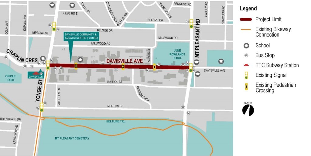
The City of Toronto is inviting residents to learn more and provide feedback on proposed road safety improvements on Davisville Avenue, between Yonge Street and Mount Pleasant Road. The proposed changes build on community priorities identified during previous phases of consultation and includes changes to intersection safety and operations, new trees and streetscaping, transit stop upgrades and new bikeways.
Public feedback, along with technical considerations and City policies and guidelines will be considered in the design recommended to City Council for final approval.
The project area is Davisville Avenue from Yonge Street to Mount Pleasant Road.
June 2026 Update
As part of the approval process, staff will report to the Infrastructure and Environment Committee of City Council on June 10. A copy of the staff report is available here.
At this time Transportation Services is proposing a phased approach to road safety changes, and its report to Infrastructure and Environment Committee recommends the following:
Transportation Services recommends moving forward with a phased approach to road safety, beginning with the measures identified in the ‘Recommended Changes’ section. As part of the approval process, staff will report to the Infrastructure and Environment Committee of City Council on June 10. A copy of the staff report is available here.
The following previously proposed changes presented for feedback during Phase 2 consultation are listed below.
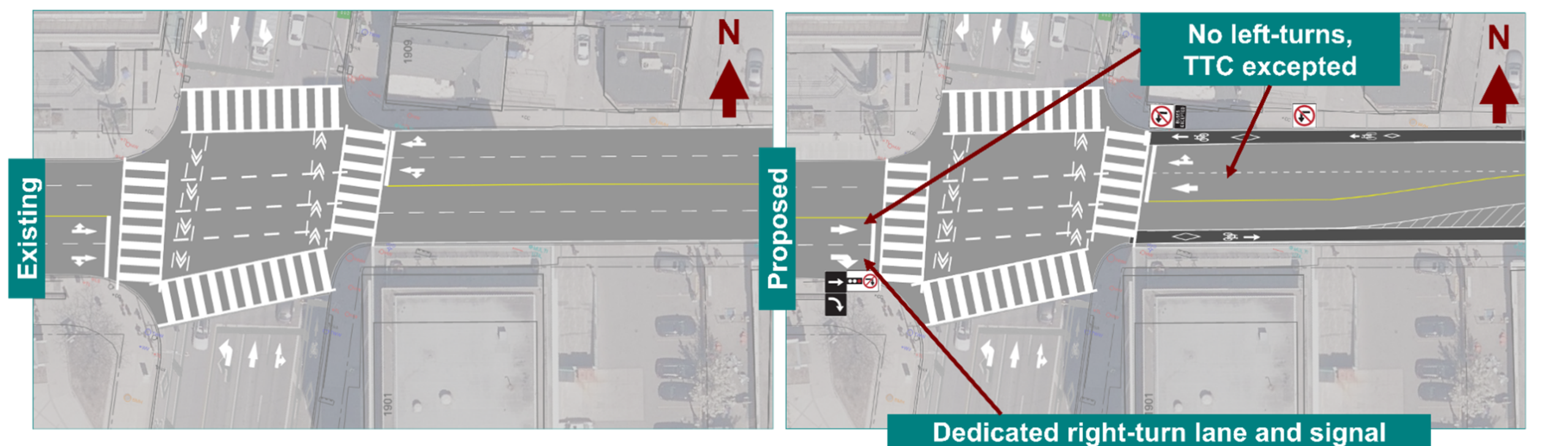
Intersection of Yonge Street and Davisville Avenue
The intersection of Yonge Street and Davisville Avenue has very high pedestrian volumes, sometimes exceeding the number of people driving, which can create conflicts with vehicles turning right and left on Yonge Street.
Changes are needed to improve safety and accessibility by reducing conflicts through improved signal timing and turn management so people walking, driving and taking transit can move through the intersection more safely and efficiently.
Proposed changes include:
Pedestrian Crossovers
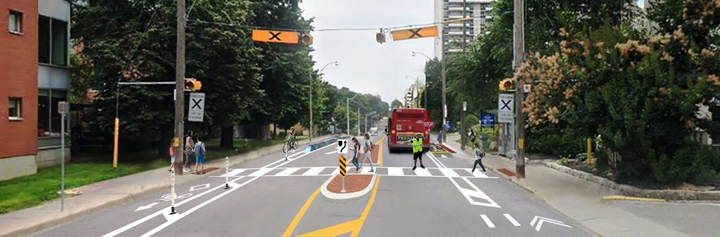
Today, community members have reported that crossing Davisville Avenue at pedestrian crossovers can feel unsafe and uncomfortable. Overly wide lanes can encourage speeding, and crossings with multiple lanes or parked vehicles can make it harder for drivers to see pedestrians and for people to feel safe crossing.
This project re-envisions Davisville Avenue as a safer street that would support more reliable and comfortable crossing at the pedestrian crossovers.
The City is proposing improvements at the existing pedestrian crossovers to make them safer through designs that encourage slower vehicle speeds and make it easier for people driving and people crossing to see each other.
Proposed changes include:
The pedestrian crossover at 50 Davisville Avenue (in front of Davisville Junior PS) could be improved as part of a future development, which would shift south side driveways and allow a full median without blocking left turns.
The project does not propose adding full traffic signals at pedestrian crossovers on Davisville Avenue. A technical warrant was conducted for the pedestrian crossover at Davisville Junior Public School. Based on analysis of traffic volumes, pedestrian delay and collision history, a signal was not warranted at this location. Full signals can result in longer wait times for pedestrians and increased congestion with negative impacts to TTC operations. Improving existing crossovers aims to improve safety while allowing people to cross when they arrive and keep all road users moving.
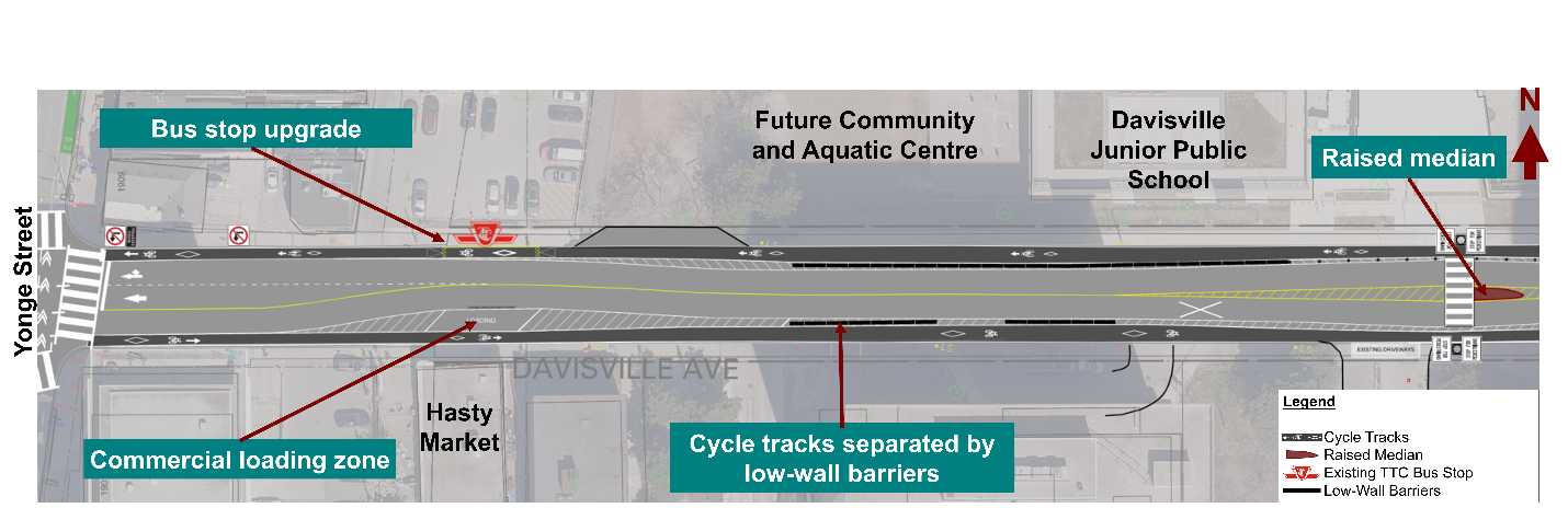
Yonge Street to Davisville Junior Public School
In this section of Davisville Avenue, the proposed design would:
Davisville Junior Public School to Pailton Crescent
In this section of Davisville Avenue, the proposed design would:
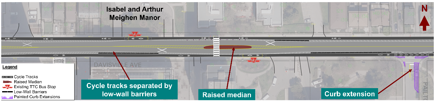
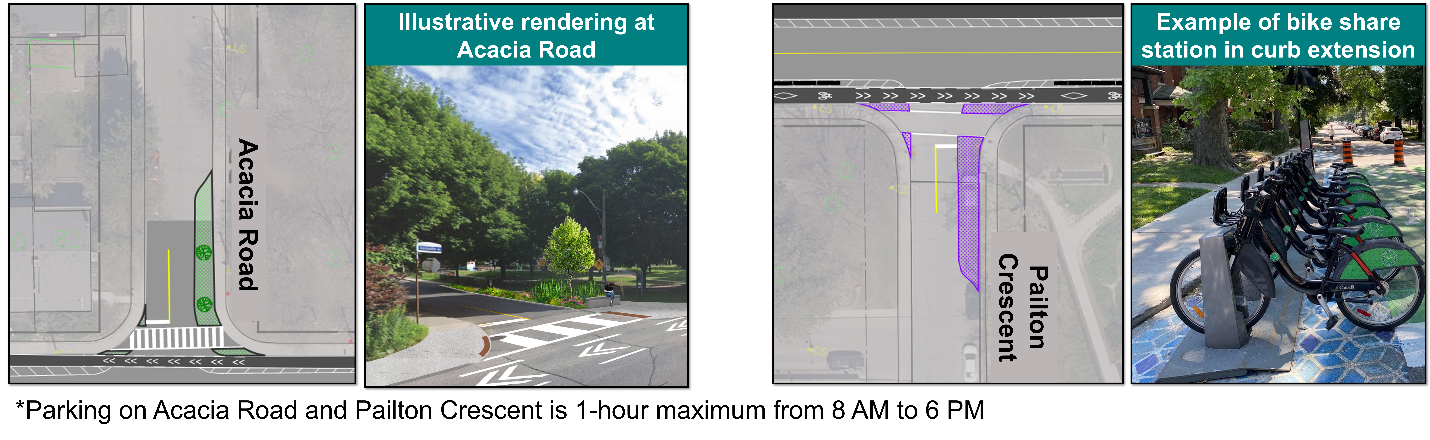
Side Streets: Acacia Road & Pailton Crescent
The City is proposing side street improvements at Acacia Road and Pailton Crescent. Curb extensions are proposed at Acacia Road and at Pailton Crescent to reduce crossing distance, encourage slower turning speeds and improve pedestrian visibility. Curb extensions provide an opportunity for streetscaping and greening improvements such as artistic road paint, trees and seating or a Bike Share Station. Access to Acacia Road and Pailton Crescent will remain.
Proposed changes include:
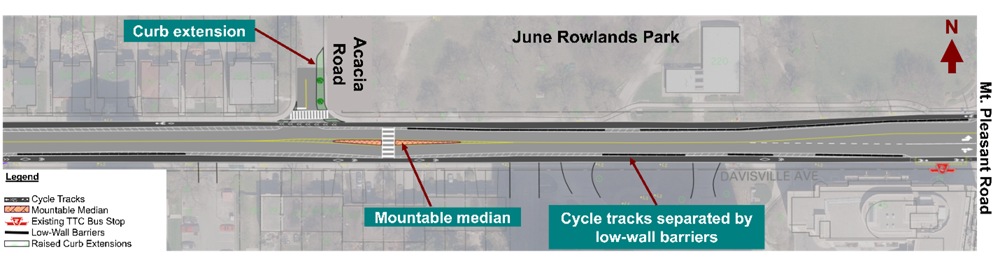
Pailton Crescent to Mount Pleasant Road
In this section of Davisville Avenue, proposed changes include:
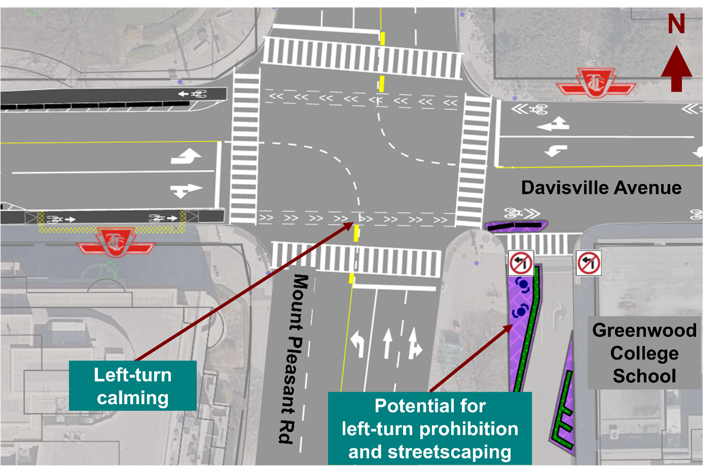
Intersection of Mount Pleasant Road and Davisville Avenue
The intersection of Davisville Avenue and Mount Pleasant Road is at the corner of two schools, a park and a senior’s home. This intersection has had three pedestrian collisions in the past 5 years, one resulting in a pedestrian fatality (2023). Changes are proposed to improve road safety and accessibility for people of all ages and abilities.
The proposed changes include:
The City is in discussions with Greenwood College School to explore prohibiting left turns from the laneway next to Mount Pleasant Parkette. Left turns at this location have poor visibility and create safety concerns for turning vehicles and crossing school children and other people walking. Prohibiting left turns would allow space for a curb extension with features such as planters, seating and artistic road paint.
The comment period for this consultation has closed. The Phase 2 Public Consultation Report summarizes feedback received.
Consultation Materials
Phase 1 Public consultation on this project took place in 2024. The report below provides a detailed summary of all consultation activities and feedback received.
While we aim to provide fully accessible content, there is no text alternative available for some of the content on this page. If you require alternate formats or need assistance, please contact us at 416-396-5785 or email jayne.armstrong@toronto.ca
The City of Toronto is proposing changes as part of the Vision Zero Road Safety Plan. The Plan’s goal is to eliminate traffic-related fatalities and serious injuries by making our roads safer for everyone, especially for seniors, school children, pedestrians and people cycling. This project is coordinated with ongoing studies for crossing and safety improvements along Davisville Avenue.
The City Council-approved 2025-2027 Cycling Network Plan Near-Term Implementation Program identifies Davisville Avenue from Yonge Street to Mount Pleasant Road for cycling improvements to connect people to destinations and existing cycling routes. The Cycling Network Plan is a comprehensive roadmap that outlines the City’s planned investment in the cycling network. It aims to connect gaps in the current cycling network and create safer and more comfortable cycling options.
Midtown in Focus (Yonge Eglinton Secondary Plan Study) was an inter-divisional study led by City Planning. The Ready, Set, Midtown: Public Realm Implementation Strategy identifies a long-term vision for Davisville Avenue as a generous pedestrian promenade with cycling lanes and large planting areas with wide-canopied trees and ample space for street furniture and other landscape elements.
Sign-up to receive project updates by email.