The City of Toronto is carrying out a Municipal Class Environmental Assessment (EA) Study to complete Phases 3 and 4 of the EA process. The Study determined the design of new major streets and for the design, realignment and/or extension of some existing major streets identified in the Golden Mile area, and builds on the recommended infrastructure improvements identified in the Golden Mile Secondary Plan Study that was completed in 2020 and included the Golden Mile Transportation Master Plan (TMP) that completed Phases 1 and 2 of the EA process.
In February 2025, City Council adopted the Preferred Alignments and Designs for the five new and reconfigured streets of the Study (EX20.11). City staff will prepare a study report and make it available for a 30-day review period in 2026.
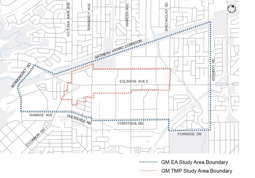
The EA Study area is located between Bermondsey Road, the Gatineau Hydro Corridor Trail, Sunrise Avenue, Holswade Road, Comstock Road and Foxridge Drive, and Kennedy Road. Significant commercial and residential development is anticipated in the project area over the next 20 to 30 years, which would bring up to 65,000 new residents and jobs.
The diagram below shows the Recommended Street Alignments and detailed plans are provided in roll plans for each street. See the discussion guide for more information on the evaluation and recommendations for each street.
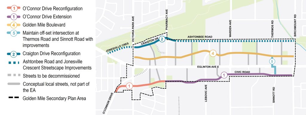
Additionally, the EA Study is exploring other streetscape improvements along Jonesville Crescent and Ashtonbee Road to Birchmount Road that do not require completion of Phases 3 and 4 of the MCEA. The improvements will ensure these streets are complete streets to support existing and future residents and businesses.
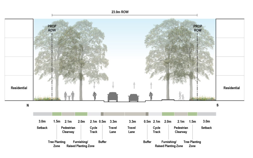
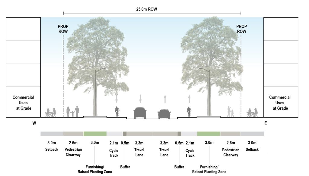
Four Alternative Street Designs were evaluated for the O’Connor Drive reconfiguration and extension west of Pharmacy Avenue, and two alternative street designs were evaluated east of Pharmacy Avenue to Birchmount Avenue.
Alternative C4 west of Pharmacy Avenue and Alternative D2 east of Pharmacy Avenue are the Recommended Street Designs for the O’Connor Drive reconfiguration and extension to support the existing and planned uses along the two streets. The typical mid-block condition for the recommended street designs have:
See roll plan that shows the Recommended Street Designs.
Three alternative street designs were evaluated for the Craigton Drive reconfiguration. Alternative E2 is the Recommended Street Design to support the existing and planned uses along the corridor.
The typical mid-block condition for the recommended street design has:
See roll plan that shows the recommended street design.
Three Alternative Street Designs were evaluated for Thermos Road and Sinnott Road.
Alternative F1 is the recommended street design to support the existing and planned uses along the two corridors.
The typical mid-block condition for the recommended street design has:
The recommended street design also includes a protected intersection at Sinnott Road and Eglinton Avenue, and intersection improvements to Thermos Road and Eglinton Avenue to provide safer facilities for people cycling and walking.
See roll plan that shows the Recommended Street Design.
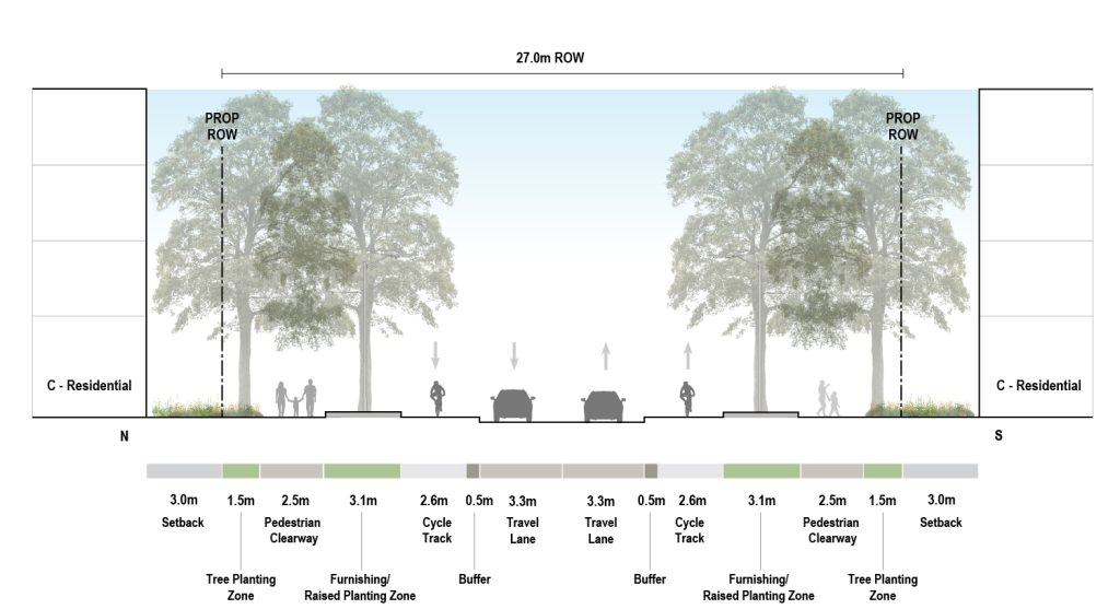
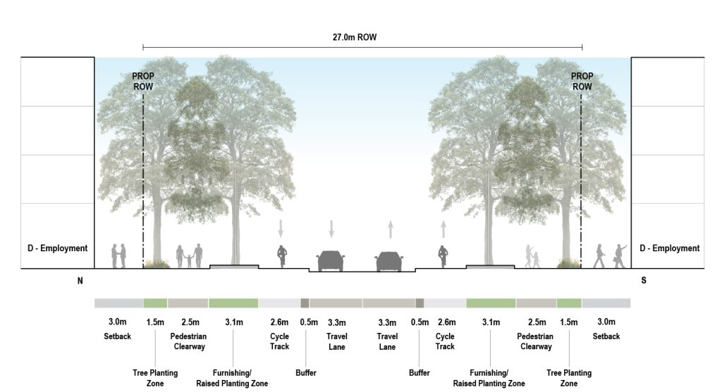
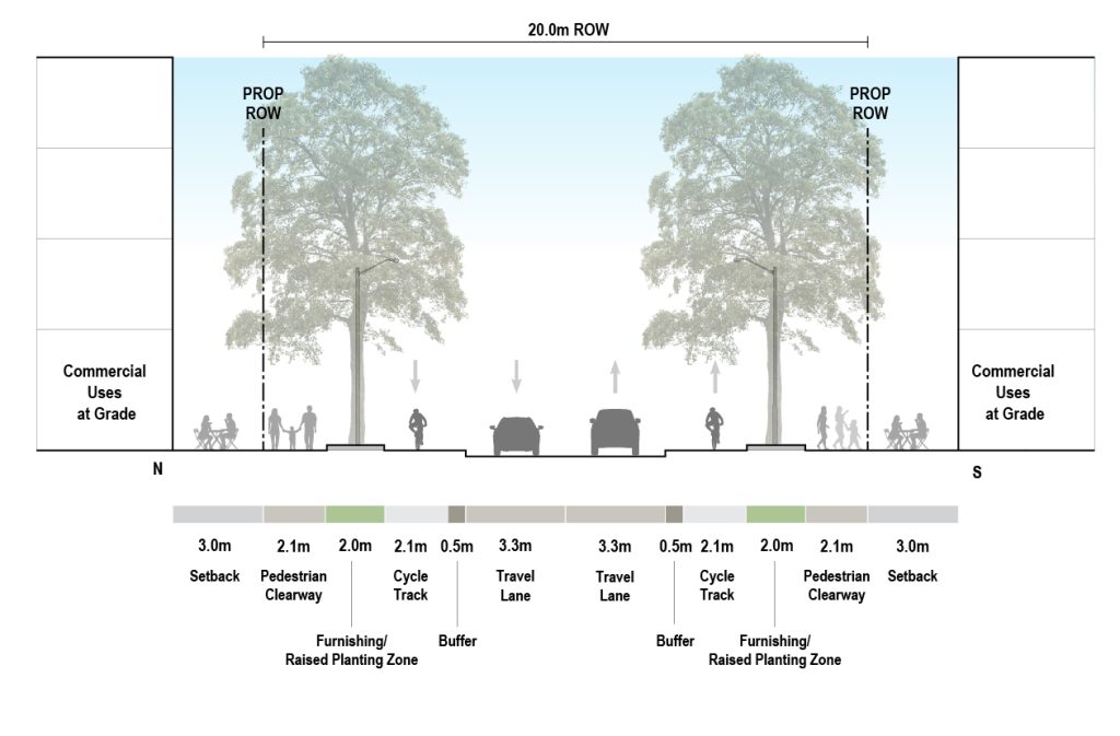
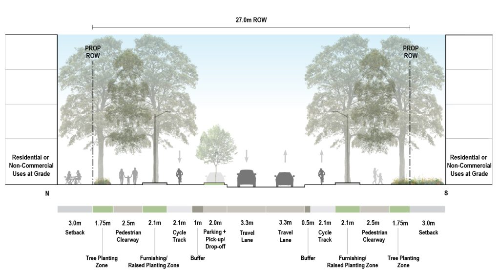
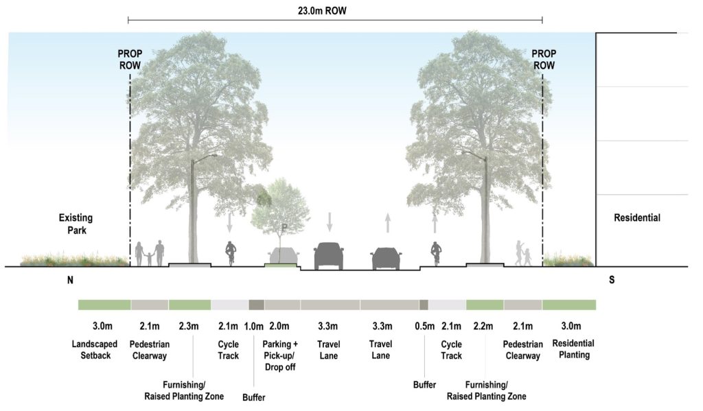
Three Street Design Alternatives were evaluated for the Golden Mile Boulevard for the 27 meter street width section, and two Street Design Alternatives for the 20 meter street width section.
Alternative B2 between Victoria Park Avenue and West Park and Alternative A2 between West Park and Birchmount Road are the Recommended Street Designs for Golden Mile Boulevard to support the existing and planned uses along the two corridors.
The typical mid-block condition for the Recommended Street Designs for the 20 metre width between Victoria Park Avenue and West Park has:
See roll plan that shows the recommended street designs.
The typical mid-block condition for the recommended street design for Golden Mile Boulevard between West Park and Birchmount Road with a 27 metre street width to support the existing and planned uses has:
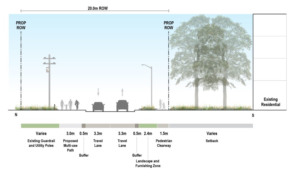
The EA Study explored improvements along Ashtonbee Road to Birchmount Road that do not require the completion of phases 3 and 4 of the MCEA. Ashtonbee Road streetscape improvements are recommended when the street requires reconstruction within the existing street width to support the existing and planned uses along the corridor.
The typical mid-block condition for the streetscape improvements has:
See roll plan that shows the recommended street designs.
The EA Study explored improvements along Jonesville Crescent that do not require the completion of phases 3 and 4 of the MCEA. Jonesville Crescent streetscape improvements are recommended when the street requires reconstruction within the existing street width to support the existing and planned uses along the corridor.
The typical mid-block condition for the streetscape improvements has:
Phase 1 Public consultation took place in 2023. The report below provides a detailed summary of all consultation activities and feedback received.
Phase 2 consultation took place in 2024. The report below provides a detailed summary of all consultation activities and feedback received.
The City of Toronto is proposing to amend the Official Plan to implement the preferred alignment for the O’Connor Drive Reconfiguration, which is being recommended through the ReNew Golden Mile Municipal Class Environmental Assessment (MCEA).
View the draft proposals below:
For questions or more information, contact:
Emily Caldwell, M.PL., MCIP, RPP (she/her/hers)
Senior Planner, Community Planning, Scarborough District
Development Review Division
Emily.Caldwell@toronto.ca
416-396-4927
The City initiated the ReNew Golden Mile Study in 2017, a study focused on developing a vision and planning framework for the Golden Mile area to meet future demands. The Golden Mile Secondary Plan was subsequently completed in 2019 and adopted by City Council in October 2020. The Golden Mile Transportation Master Plan (TMP) was completed in November 2019. The Golden Mile EA builds on the TMP to complete Phases 3 and 4 of the Municipal Class EA process.
To receive updates by email, subscribe to the project email.