The Phase 2 Public Consultation Report (view the Report under the Public Consultation tab) summarizes feedback received. Staff are refining the plan and will present recommendations to Etobicoke York Community Council on May 13, 2024.


The Mimico Neighbourhood Mobility Plan (NMP) will identify, prioritize and recommend short and long-term improvements to traffic operations and road design to support road safety for all modes of transportation including vulnerable road users (e.g. seniors, school children, people walking and cycling) in the Mimico study area.

The following areas of concern will be addressed:

  • traffic fatalities
  • cut-through traffic and excessive vehicular volume on local roads
  • excessive speeding on local roads
  • non-compliance with traffic regulations and signage
  • road and intersection designs that raise safety concerns

The Mimico Neighbourhood Mobility Plan (NMP) project area is located between Royal York Road to the west, Manchester Street/Burlington Street/Victoria Street to the north, Louisa Street to the east, and Lake Shore Boulevard West to the south. The area also includes Judson Street/Royal York Road intersection and the Newcastle Street /Royal York Road intersection, and will take into account dynamics from a broader context area.

The project area is located between: Newcastle Street and rail corridor to the north, Mimico Creek to the east, Lakeshore Blvd. W. to the south, and Royal York Rd. to the west.

Council Decisions

 Project Description

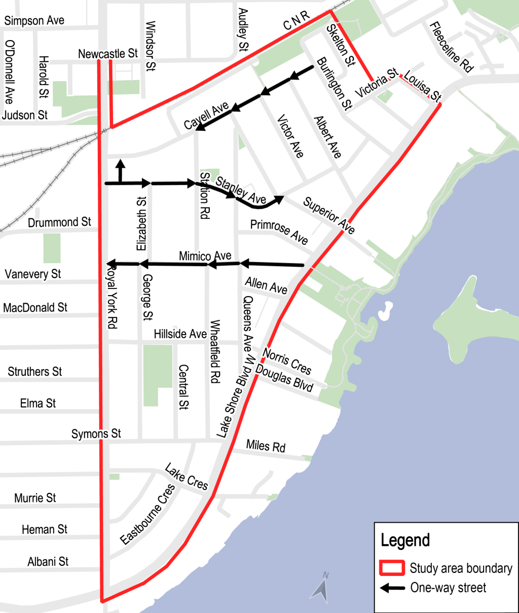
To date, there have been requests for traffic calming service requests, stop signs, roundabouts, speed reductions and safety assessments. Automated Speed Enforcement results also show high rate of violations.

As part of the evaluation, the City has retained a consultant to conduct an In-Service Road Safety Review (ISSR) of the study area. Using site visits, collision history, traffic counts and other data, this review will identify and prioritize safety issues across the neighbourhoods and options to address them.

What is a Neighbourhood Mobility Plan (NMP)?

In 2018 Etobicoke York Community Council directed City staff to work with the community to develop a comprehensive plan to address community concerns. City staff will use a holistic approach to assess and manage traffic issues within the neighbourhood. The NMP will consider all modes of transportation, with an emphasis on improving conditions for vulnerable road users.

Historically, traffic management issues have been addressed by making changes only to a particular street or intersection. Instead of making one isolated change, a NMP employs a broader, neighbourhood perspective to develop integrated solutions that, together, support local objectives for mobility. Through an NMP approach, the City works with local communities and neighbourhoods to identify short-term improvements that can be implemented in one to five years, as well as a longer-term vision for projects over five years into the future.

Study Process

The participation of local residents and stakeholders is essential to identifying appropriate and effective traffic, speeding and road safety improvements for the neighbourhood.

Following the first Virtual Public Meeting, the NMP process will continue, which involves identifying and implementing ‘quick win’ improvements supported by the community. Long-term improvements will be proposed at a second public meeting for feedback. Once completed, a final Mimico Mobility Plan (two to ten year implementation) will be shared on this project web page.

The City of Toronto is inviting residents, businesses and organizations to learn more and provide feedback on the Mimico Neighbourhood Mobility Plan. Public opinions, along with technical and policy considerations will be used to inform City staff recommendations and decisions to be made by City Council

Consultation will take place over two phases between Spring 2022 and Winter 2023:

  • Phase 1: presented background information, consulted the community on issues commonly experienced in the neighbourhood, and collected ideas for actions and changes.
  • Phase 2: consulting on proposed short-term actions (6 to 18 months) using temporary, flexible materials like signs, paint, and bollards, and identify longer term changes which can be implemented alongside future programmed road work.

Information, reference materials, and reports on public consultation activities will be posted here.

Etobicoke York Community Council

As part of the approval process, staff will report to the Etobicoke York Community Council on May 13, 2024 (date is tentative) on the plan and specific recommendations where additional authority is required. The meeting agenda and staff report are made available to the public one week before the meeting. Details about the staff report and how to participate will be shared in advance of this meeting.

Many factors are considered when providing recommendations to Council including public opinion, technical considerations, policy considerations, costs and timelines.

Community Council may approve the recommendations, make changes, or send it back for more information. If approved, staff would begin planning for implementation.

How to Participate

Learn more about this process.

Public Drop-in Meeting 2

The City hosted a drop-in event on December 11, 2023 from 6 p.m. to 8 p.m. Members of the public were able to view project information panels and speak with staff one-on-one.  The meeting was attended by over 100 participants. Public consultation was also conducted with an online survey, by phone and by mail. A meeting summary will be provided on this web page.

Meeting Materials

Consultation Report

Virtual Public Meeting 1

The City hosted a virtual public meeting on June 14, 2022, from 6:30 p.m. to 8:30 p.m. Members of the public were invited to provide feedback and ask questions. Public consultation was conducted online, by phone and by mail. The meeting was attended by 39 participants. A meeting summary will be provided on this web page.

Meeting Materials

  • Presentation (Excessive Speeding Slide 18 revised June 14, 2022)

Mapping Comments

  • Feedback received from online mapping tool (closed for comment June 28, 2022).

Consultation Report

Stakeholder Interviews

Individual one-on-one meetings with local stakeholders like schools, businesses and other local organizations will help confirm local issues and discuss the specific opportunities and challenges (e.g. school drop off and pickup, nearby intersections, parking, etc.).

Subscribe for Updates

Please email Maogosha Pyjor at maogosha.pyjor@toronto.ca to be added to the project list and to stay informed.


A range of options are proposed and planned to improve traffic operations and road design to support road safety for all modes of transportation. An overview of the actions proposed are summarized below.

Map showing recommendations for the Mimico Neighbourhood Mobility Plan including intersection improvements & new pedestrian crossings; speed humps to address excessive speeding & make local routes less attractive for through trips; directional changes to discourage through trips on local streets; proposed bikeway improvements on Royal York Road; and implementation of bikeway improvements on Superior Avenue.

Background: Planned Cycling Facilities and Median

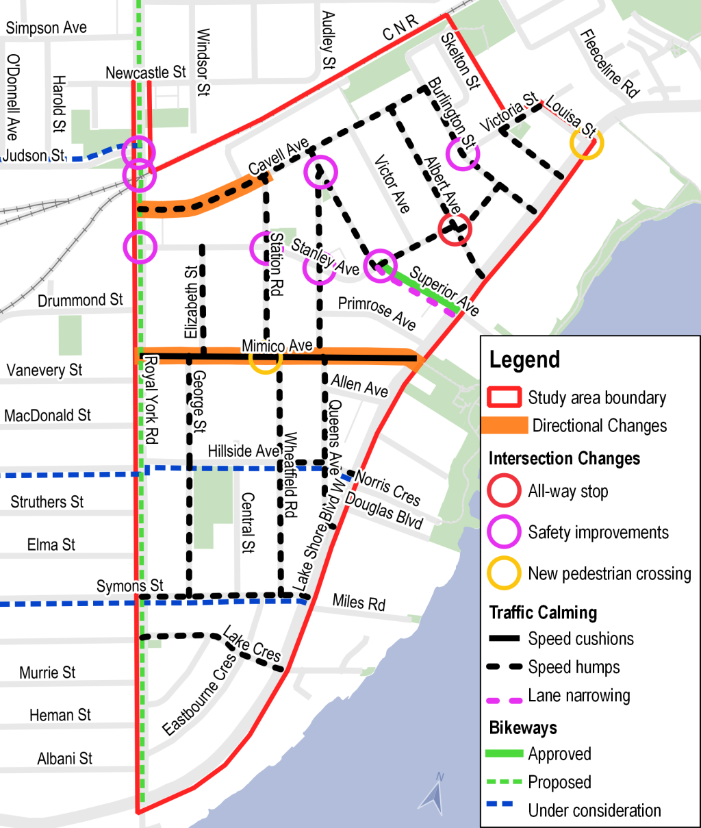
Due to the condition of the street and sewers, Superior Avenue has a programmed road resurfacing and sewer upgrade commencing in March 2024. The Superior Avenue bikeways are bundled with the planned work. Council approval was sought earlier in the process so the work could begin. The design has been approved by City Council for implementation in 2024 Agenda Item History – 2023.IE4.3 (toronto.ca). This means that the plan for Superior Avenue does not require further approvals.

Designs for Superior Avenue were developed in advanced of the Neighbourhood Mobility Plan (NMP) and then modified based on the feedback received. The City is planning to replace the existing shared lane markings and install uni-directional cycle tracks (one westbound track and one eastbound track) and safety enhancements on Superior Avenue from Stanley Avenue to Lake Shore Boulevard West. These changes address excessive speeding, aggressive driving, and may also discourage non-local traffic on local streets. These were key concerns identified by the community in the first phase of engagement for the Mimico NMP.

For Superior Avenue residents, community feedback is critical and has informed the final design. Residents will receive additional information on the construction timing through mailed notices.

Planned Changes

A plan diagram map of a street showing a bikeway upgrade on Superior Avenue in Toronto including infrastructure features such as precast concrete curbs, decorative planters as barrier delineators, tactile walking surface indicators, new signage, and plastic and hazard bollards.

Following community feedback, the planters in the median as presented in the above map and at the December 2023 Public Drop-In Event will not be installed. Up to two in-road flexible speed signs will be installed in the median.

Design elements which stay the same as presented during the Phase 2 of public consultation include:

  • New asphalt in the motor vehicle lanes and pavement markings
  • New painted central median
  • New painted crosswalk markings at the intersection of Superior Avenue and Stanley Avenue
  • Accessibility features such as curb ramps and tactile warning surface indicators
  • New cycle tracks including new pavements markings, pre-cast concrete curbs, and bollards
  • Reduction of 25 on-street parking spaces
Design shows current cross section for Superior Avenue between Lake Shore Boulevard West and Stanley Avenue consisting of shared lane markings for bicycle, parking for motorized vehicles, two lanes of traffic (one northbound, one southbound) and sidewalks on both sides of the street.
Existing cross section of Superior Avenue with shared lane markings for people cycling
Cross-section shows cycle tracks on both sides of street, painted median in the middle and two lanes of motor vehicle travel.
Planned cross section of Superior Avenue with cycle tracks and centre median

Superior Avenue Parking

These planned changes result in a reduction of 25 on-street parking spaces. In order to understand this impact a parking study was conducted.

  • Parking inventory counted 127 on-street spaces and 103 additional publicly accessible spaces for a total of 230 spaces in the immediate vicinity of Superior Ave.
  • Parking occupancy in this area was observed for 12 hours per day, between 8 a.m. and 8 p.m., on Wednesday October 26, Saturday October 29, and Sunday October 30, 2022
  • Peak parking demand in the area occurred between 3 p.m. and 4 p.m. on Sunday October 30, 2022. At that time there were 23 vehicles parked on Superior Avenue between Stanley Avenue and Lake Shore Boulevard West and 62 spaces (27 per cent of total publicly accessible supply) available in the observation area
  • On average throughout the observation period there were 139 spaces (60 per cent of total publicly available supply) available in the observation area

Proposed Parking Management Measures

Proposed change:

  • Residential on-street permits which entitle permit holders to park their car on the street within a specified area exclusively during permit parking hours, including overnight
  • Can be implemented with Community Council approval and positive local resident polling

Impacts

  • Addresses concerns around potential reduced on-street parking on Superior Avenue, Mimico Avenue
  • Addresses concerns around on-street parking on Cavell Ave. related to Mimico GO
  • Reduces speeding on local streets

Responses to Resident Questions

  1. Why are you proposing a cycle track on this small street, why not a painted bike lane instead?

The City of Toronto Bikeway Design Guideline recommends physically separated facilities (cycle tracks) on any street where operating speeds are greater than 40 km/hr, whether they are local streets or arterial roads. Data collected by Transportation Services shows that the motor vehicle operating speed on Superior Avenue is approximately 48km/hr.

  1. How will winter maintenance occur on the street?

Any approved bike lane design includes a maintenance program for snow clearing and street cleaning.  For streets with cycle tracks, there are two plows used: one to clear the road and one to clear the cycle track. One would come shortly before the other. ­All streets and cycle tracks are cleared using the City’s level of service for winter maintenance. The windrow (snow pile) at the end of driveways from plowing the cycle track would be substantially smaller than the one at the road.

  1. Concern about the removal of on-street parking, overnight parking, accessibility and convenience for older residents and area visitors.

Parking will continue to be available on side streets and nearby lots, and the layby parking will remain on the south side of Superior Avenue just west of Lake Shore Boulevard West.

Please note: On all public roads in Toronto an unsigned maximum three-hour parking limit exists, including on Superior Avenue, unless there is signage posted indicating otherwise. Overnight parking or parking for longer than 3 hours on Superior Avenue is not permitted. Please refer to the City webpage on Parking Regulations for more information.

  1. Concerns about the aesthetics of planters and curbs in the centre median.

The planters and curbs proposed in the centre median have been removed from the design based on community feedback. Up to two in-road flexible speed signs will be installed in the median. These signs are installed in the centre of the road, serving as both a visual reminder of the posted speed limit and a physical device to slow motor vehicle speeds as they pass the sign.

  1. Have you thought about emergency medical services (EMS) and Fire Services?

Safe access for emergency vehicles is a fundamental part of the project design process and EMS and Fire Services have been engaged in the Superior Avenue bikeway design.

Need assistance?  While we aim to provide fully accessible content, there is no text alternative available for some of the content on this page. If you require alternate formats or need assistance understanding our maps, drawings or any other content, please contact us at 416-338-2850 or email maogosha.pyjor@toronto.ca