November 17, 2023: Phase 2 of this project, which included addition of contraflow bike lanes, directional changes and other safety improvements on Palmerston Boulevard between Bloor Street and College Street and Lennox Avenue between Palmerston Boulevard and Markham Street is completed. Road users are urged to observe all road markings and other signage installed.


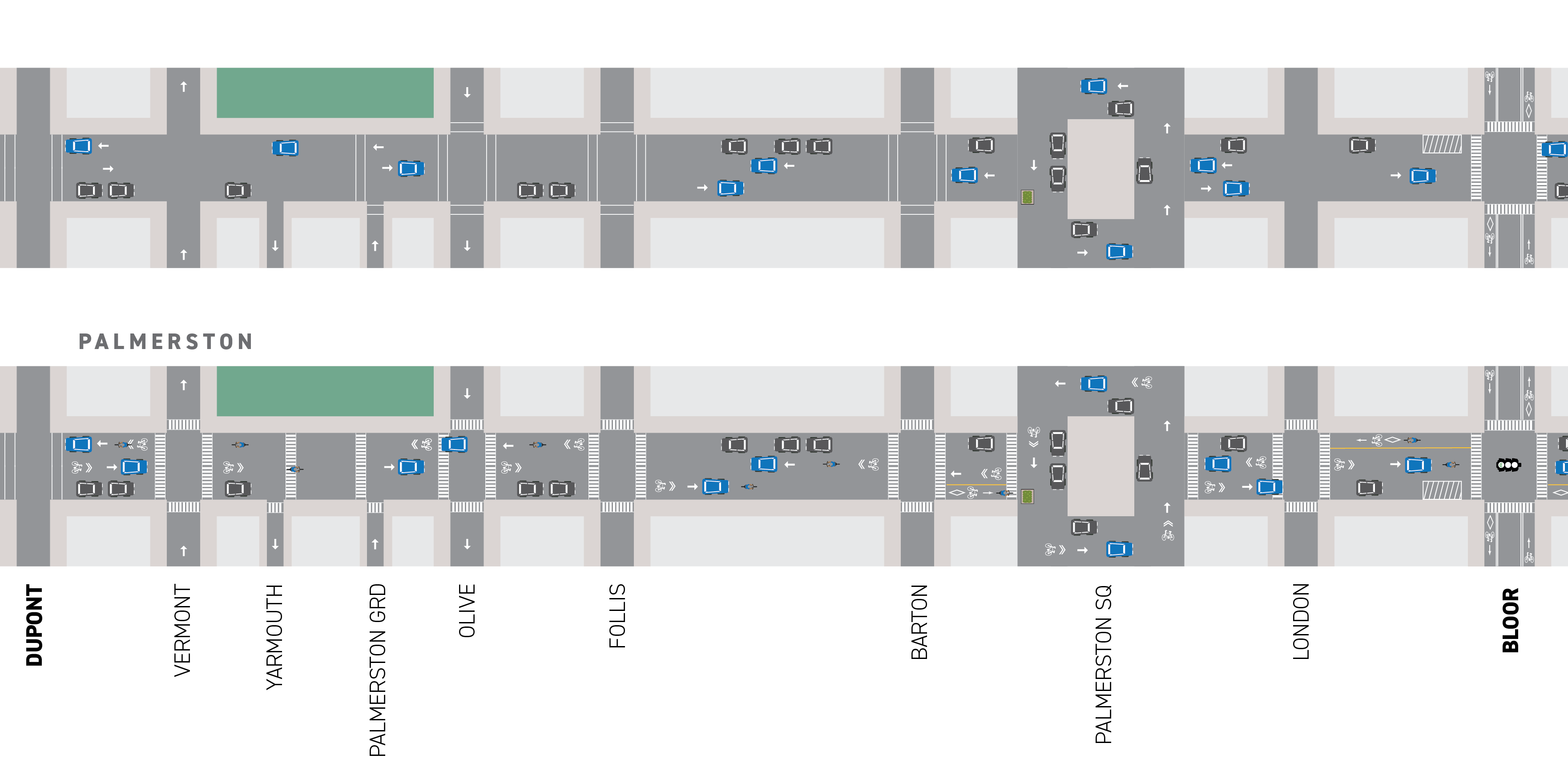
The City has installed cycling, pedestrian, and road safety upgrades on Palmerston Avenue, Palmerston Square and Palmerston Boulevard as well as Tecumseth Street. The project was approved in December 2021.

The bike lanes, contra-flow lanes, cycle tracks, and wayfinding markings will expand the local cycling network and connect to the bikeways on Bloor Street West, Harbord Street, College Street, Richmond Street, Adelaide Street West, and Wellington Street West.

The traffic changes include modifications to the direction of certain blocks to enable the new bikeways and reduce through traffic, while maintaining local access, as well as a reduced number of on-street parking spaces in some locations.

September 25, 2023: Installation Update

The City has recently completed upgrades to the Watermain on Palmerston Boulevard between Bloor Street and College Street. Cycling installation is planned for installation beginning in October and ending in November 2023. Please see the Installation Notice for more details.

August 31, 2023: Installation Update

The City is in the final stages of completing upgrades to the Watermain on Palmerston Boulevard between Bloor Street and College Street. It is anticipated that this work will be completed by the beginning of September 2023. Following this, cycling infrastructure will be installed, including signal work at Bloor Street and Palmerston Boulevard and Harbord Street and Palmerston Boulevard over a three-week period. The main changes in traffic lanes and traffic flow directions between Bloor Street and College Street will be completed afterwards, bringing the project to a close in mid-October 2023.

July 12 to 14, 2022: Installation Updates

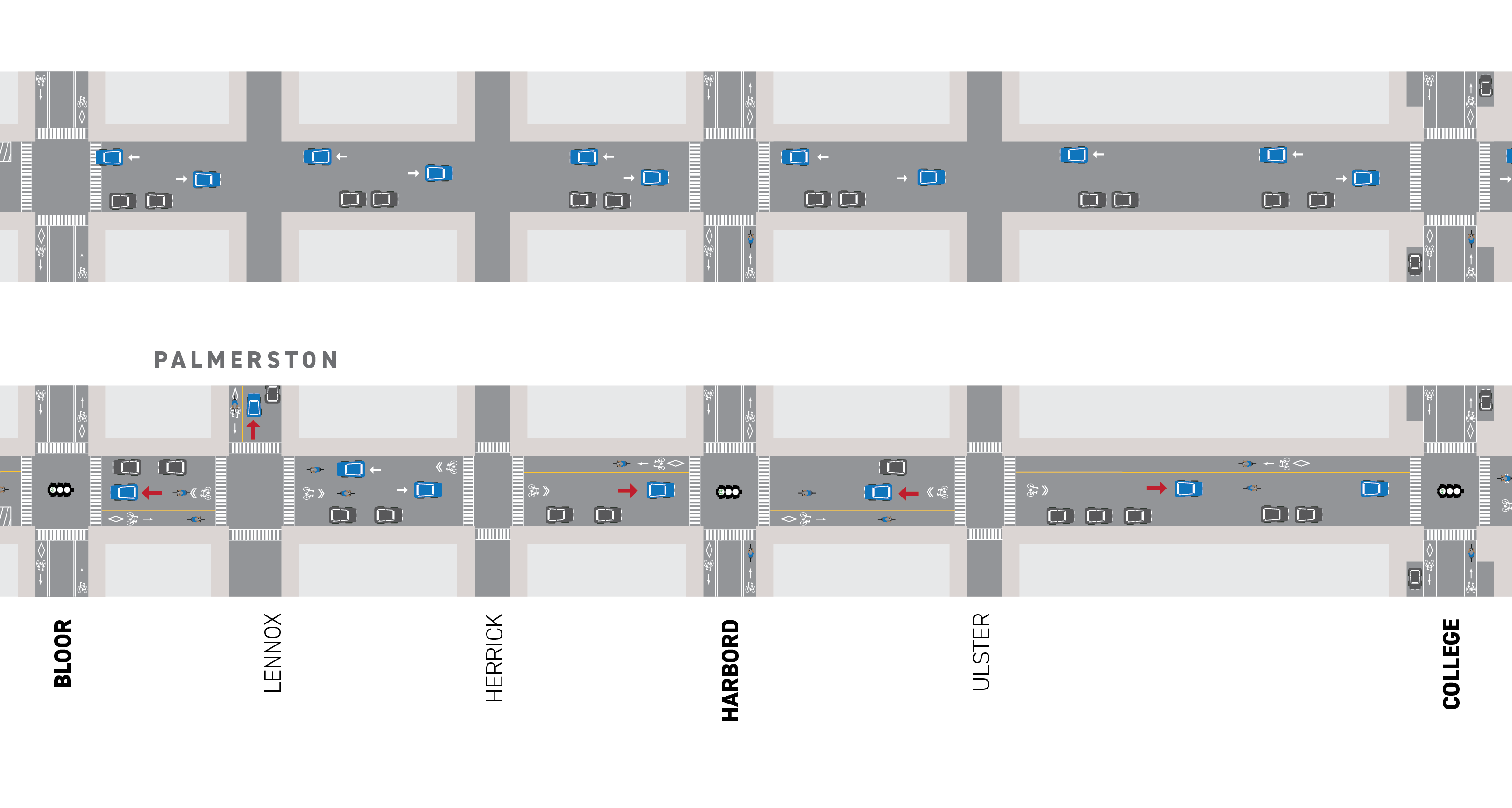
Installation update: Palmerston Avenue- London Street to Bloor Street

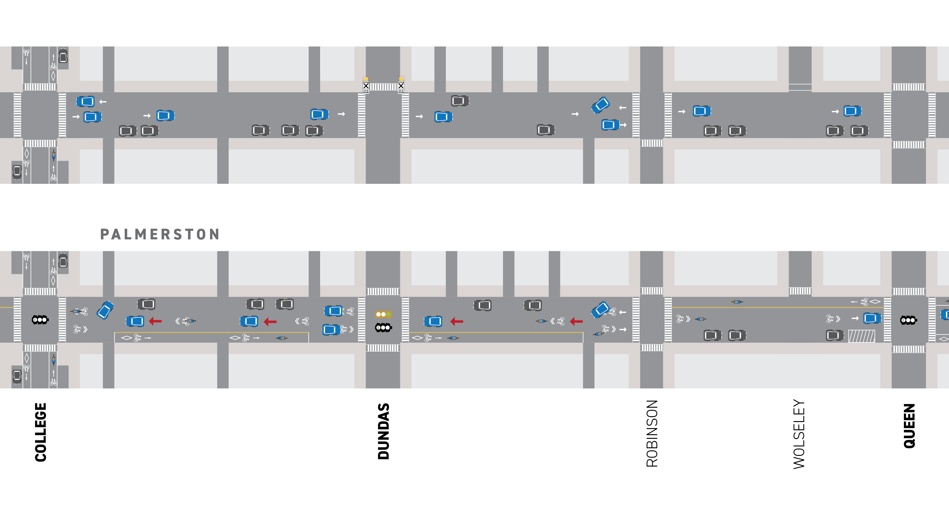
Installation Update: Palmerston Avenue- College Street to Robinson Street
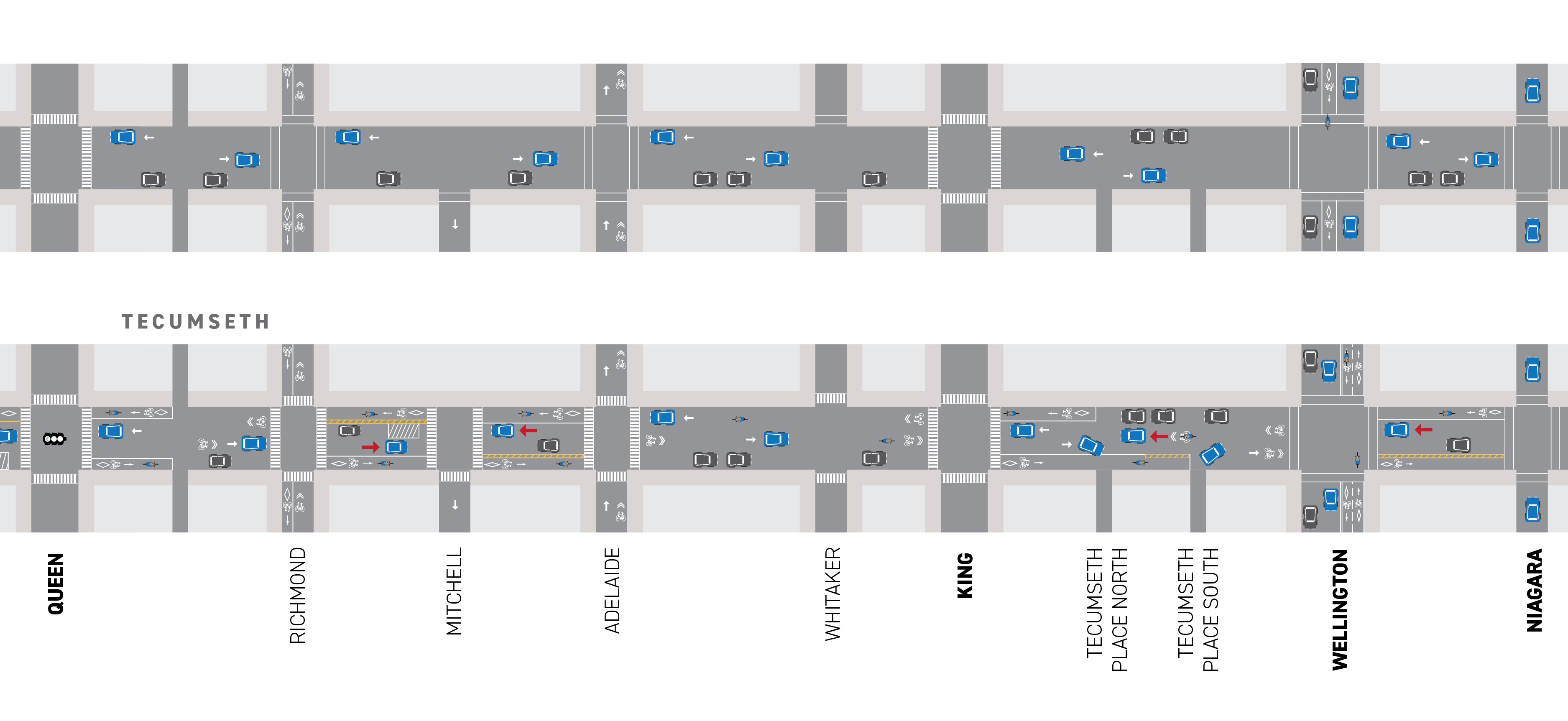
Installation Update: Tecumseth Street – Richmond Street to Adelaide Street

Installation Update: Tecumseth Street- King Street to Niagara Street

June 16, 2022: Installation Updates

From July to September 2022 and spring 2023, the City will install contra-flow bike lanes, protected cycle tracks and other safety improvements including wayfinding markings on Palmerston Avenue, Palmerston Square, Palmerston Boulevard and Tecumseth Street from Dupont Street to Niagara Street, and on Lennox Street from Palmerston Boulevard to Markham Street.

Public Information Event

On July 5, 2022, the City hosted a Virtual Public Information Event that provided residents with an opportunity to learn more about the planned changes and implementation timeline.

Public Information Meeting Minutes

View the Installation Notice

View the Presentation

In coordination with the improvements to Palmerston Boulevard, Transportation Services  completed the Mirvish Village Readiness Assessment. The study encompassed an assessment of existing conditions in the study area, and a review of forecasted travel demand associated with the new development at Mirvish Village. The study was completed to better understand the neighbourhood’s transportation infrastructure and travel behaviours today and assess the capacity of the local road network to accommodate the travel needs of new neighbours and visitors in the future.

The study was initiated in 2021 in response to City Council direction and concerns raised by members of the community about the potential travel patterns of new Mirvish Village residents and visitors. Existing residents of Mirvish Village expressed concerns about motor vehicle volumes, speeds and overall road user safety on residential streets neighbouring the new, mixed-use developments after they are occupied. The Mirvish Village Readiness Assessment reviewed probable paths of travel to and from the development site by all modes, and considered a list of traffic management changes which could discourage people driving from selecting routes through the neighbourhood.

The Mirvish Village Readiness Assessment concluded that the transportation network will adequately serve current and future area residents and encourage the desired behaviours from people using a motor vehicle when considering five street improvements:

  1. bikeway on Palmerston Boulevard (completed in 2023)
  2. diversion on Lennox Street (completed in 2023)
  3. speed bumps in the laneway between Markham Street and Bathurst Street (completed in 2023)
  4. Speed humps (which are a slightly smaller version of a speed bump, but longer) on Markham Street (as approved 2023.TE3.32, targeting installation in 2024)
  5. upgrades to the Lennox Street and Bathurst Street intersection, to be delivered through the Mirvish Village development

More information about the study history, findings and recommendations can be found in the 2023 report to Toronto and East York Community Council, item 2023.TE3.32.

Prior to the 2021 assessment, the City reviewed the Traffic Impact Study submitted as part of the Mirvish Village development application, in 2017. At this time, an existing conditions assessment was completed to better understand travel behaviour of road users in the neighbourhood. Data was collected and residents were consulted to give staff a better understanding of these concerns.

Informing Change: Data-driven Assessments and Recommendations

Local traffic data was compiled and analyzed to assess motor vehicle traffic trends in the neighbourhood and inform potential changes. Staff examined motor vehicle counts, collision history, street network characteristics, traffic management features, and community concerns and requests to respond to travel behaviours and patterns on neighbourhood streets.

In response to City Council  direction (Item 2022.MM47.35), staff reviewed traffic trends on Markham Street and Lennox Street to better understand motor vehicle speeds and volumes. Traffic counts, which quantify motor vehicle speed and volume, found that:

  • On Markham Street:
    • Daily traffic volumes range from 100-174 vehicles per day, below the expected capacity of a local road (up to 2,500 vehicles per day).
    • The operating speeds of motor vehicles range from 31.4-33.9km/hr, slightly higher than the posted speed limit of 30km/hr.
  • On Lennox Street:
    • Daily traffic volumes range from 850-2,350 per day, below the expected capacity of a collector road (up to 8,000 vehicles per day).
    • The operating speeds of motor vehicles range from 27.5-29.3km/hr, below the posted speed limit of 30km/hr.

The changes on Palmerston Boulevard and Lennox Street were determined to best achieve the goal of mitigating motor vehicle through-traffic associated with new development, while maintaining safety, mobility and access for residents of neighbourhood streets. The traffic calming measures on Markham Street and the laneway between Markham Street and Bathurst Street encourage the desired behaviour from people using a motor vehicle while living at, working at, shopping at, visiting, or otherwise using the new Mirvish Village.

Directional Changes

This image shows the newly-installed bike lanes and changes in traffic directions.

This legend explains the icon in the previous image

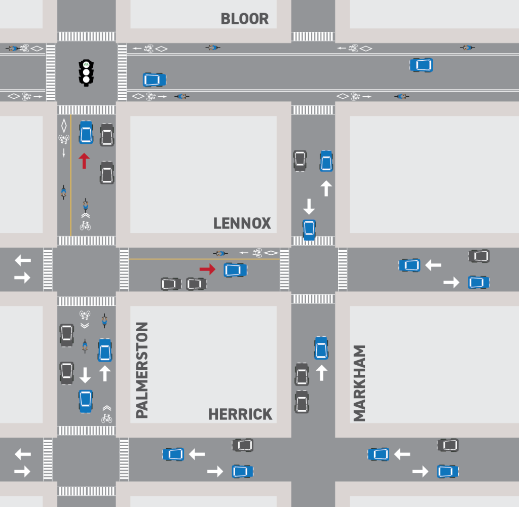
If you drive: Lennox Street has been converted to a one-way eastbound thoroughfare between Palmerston Boulevard and Markham Street. Between Markham Street and Bathurst Street it remains a two-way thoroughfare to be shared between people driving and people cycling. Markham Street between Herrick Street and Lennox Street remains one-way northbound for motor vehicles. Markham Street remains closed between Lennox Street and Bloor Street West and will be reopened pending the completion of the Mirvish Village development.

If you cycle: A contraflow bike lane and shared bike lane have been added to Lennox Street between Palmerston Boulevard and Markham Street to connect to the new cycling facility on Palmerston Boulevard. Shared wayfinding markings have been added to Lennox Street between Markham Street and Bathurst Street.

Enforcement

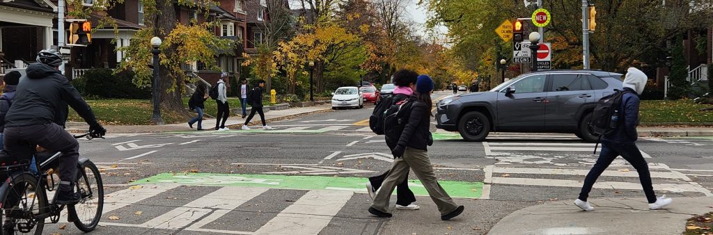
All road users are required to obey all road markings and signs in the area. While we understand it takes time for road users to adapt to the change, we continue to encourage obedience. Illegal travel in the wrong direction may result in conflicts among road users, including people driving, cycling or with pedestrians which can result in collisions, injury, or death. The addition of cycling facilities and directional changes create a safe connection for people cycling and reduce cut-through traffic, which also helps to it safer for people walking. Staff will continue to monitor changes to understand the impacts of the project.


Phase 1: Installation July-September 2022

This map represents the existing and planned designs for all road users, from Dupont Street to Bloor Street
The first image represents the road configuration before installation. The second image represents the planned changes to the road configuration.

If you drive:

  • No change to travel
  • New all-way stop controls at Palmerston Square (north and south legs).
  • Right-turn prohibition during the red traffic signal indication southbound at Bloor Street.

If you park or load on the street:

  • Parking permit hours remain
  • Net parking impact = -7
  • Pick-up and drop-off at Palmerston Avenue Junior School and the Boys and Girls St. Alban’s Club maintained.
  • Curbside loading space north of Bloor Street moved to west side to improve road safety and visibility, making space for the contra-flow bike lane.

If you cycle:

  • Cycling allowed in both directions on Palmerston Avenue
  • Shared-lane wayfinding markings added between Dupont Street and Barton Avenue; and at Palmerston Square to London Street.
  • Contra-flow bike lanes added between Barton Avenue and Palmerston Square (north leg); and London Street and Bloor Street to allow people cycling to travel north and south where vehicle flow is one-way.

If you walk:

  • Additional crosswalks; pavement markings for pedestrian crossings converted to zebra markings at multiple locations.
  • New stop controls for improved safety at Palmerston Square

Phase 2: Installation Fall 2023

This map represents the existing and planned designs for all road users from Bloor Street to College Street
The first image represents the road configuration before installation. The second image represents the planned changes to the road configuration.

If you drive or park on the street:

One-way conversions:

  1. Palmerston Boulevard between Bloor Street and Lennox Street converted to one-way northbound.
  2. Lennox Street between Palmerston Boulevard and Markham Street converted to one-way eastbound (see Council motion).
  3. Palmerston Boulevard between Herrick Street and Harbord Street converted to one-way southbound.
  4. Palmerston Boulevard between Harbord Street and Ulster Street converted to one-way northbound.
  5. Palmerston Boulevard between Ulster Street and College Street converted to one-way southbound.
    • Right-turn prohibitions during the red traffic signal indication northbound at Bloor Street ; northbound and southbound at Harbord Street; southbound at College Street.
    • Permit parking hours remain unchanged.
    • Parking made permanent on east side from Bloor Street to Lennox Street and Harbord Street to Ulster Street; west side from Lennox Street to Harbord Street and Ulster Street to College Street; on south side of Lennox Street between Palmerston Boulevard and Markham Street.
    • Net parking impact = +8 spaces

If you cycle:

  • Cycling allowed in both directions on Palmerston Boulevard and Lennox Street.
  • Contra-flow bike lanes added to Palmerston Boulevard from Bloor Street to Lennox Street and from Herrick Street to College Street; on Lennox Street from Markham Street to Palmerston Boulevard.
  • New bike signal heads added at Bloor Street, Harbord Street, and College Street intersections along Palmerston Boulevard.

If you walk:

  • Pavement markings for pedestrian crossings converted to zebra markings at multiple locations.
  • Investigation into controlled crossing opportunities at Bloor Street and Markham Street ongoing.

Changes to Lennox Street

  • To address community concerns about motor vehicle volumes and road user safety, Transportation Services is proposing changes to Lennox Street:
    • Introduce a one-way block on Lennox Street, between Palmerston Boulevard and Markham Street, permitting eastbound motor vehicle movements.
    • Introduce a contra-flow bike lane on Lennox Street, between Palmerston Boulevard and Markham Street, permitting westbound cycling movements.
  • The changes were determined to best achieve the goal of mitigating motor vehicle through-traffic associated with new development, while maintaining safety, mobility and access for residents of neighbourhood streets.

If you drive or park on the street:

  • Eastbound motor vehicle movements will be permitted on Lennox Street between Palmerston Boulevard and Markham Street.
  • Permit parking and car-share parking will be made permanent on the south side of Lennox Street

If you cycle:

  • Eastbound and westbound cycling movements will be maintained on Lennox Street between Palmerston Boulevard and Markham Street, through shared lane
  • Shared-lane wayfinding markings added eastbound.
  • Contra-flow bike lane added westbound.

Phase 1: Installation July-September 2022

This map represents the existing and planned designs for all road users from College Street to Queen Street
The first image represents the road configuration before installation. The second image represents the planned changes to the road configuration.

If you drive, park or load on the street:

One-way conversions:

  • Palmerston Avenue between the first laneway south of College Street and the first laneway north of Dundas Street converted to one-way northbound.
  • Palmerston Avenue between Dundas Street and the first laneway north of Dundas Street converted to two-way.
  • Palmerston Avenue between Dundas Street and the first laneway north of Robinson Street converted to one-way northbound.
  • Curbside loading space on west side north of Queen Street.
    • Permit parking hours remain
    • Parking made permanent on the east side from College Street to Robinson Street.
    • Net parking impact = -4
    • Pedestrian crossover (PXO) converted to full traffic signal at Dundas Street.

If you cycle:

  • Cycling allowed in both directions on Tecumseth Street
  • Shared-lane wayfinding markings added between College Street and the first laneway south of College Street; from Dundas Street to the first laneway to the north; from Robinson Street to the first laneway to the north.
  • Contra-flow bike lanes added to Palmerston Avenue from the first laneway south of College Street to the first laneway north of Dundas Street; from Dundas Street to the first laneway north of Robinson Street; from Robinson Street to Queen Street.
  • New bike signal heads added at Queen Street.

If you walk:

  • Pavement markings for pedestrian crossings converted to zebra markings at multiple locations.
  • Pedestrian crossover (PXO) converted to full traffic signal at Dundas Street, formalizing the intersection for improved safety.

Phase 1: Installation July-September 2022

This is a map depicting existing and planned designs for road users between Queen Street and Niagara Street
The first image represents the road configuration before installation. The second image represents the planned changes to the road configuration.

If you drive, park or load on the street:

One-way conversions:
  • Tecumseth Street between Richmond Street and Mitchell Avenue converted to one-way south.
  • Tecumseth Street between Mitchell Avenue to Adelaide Street converted to one-way northbound.
  • New stop controls at Tecumseth Street and Mitchell Avenue.
  • Curbside loading space on east side between Richmond Street and Mitchell Avenue.
    • Parking moved to east side from Richmond Street to Mitchell
    • Net parking impact between Queen Street and Niagara Street = -4

If you cycle:

  • Cycling allowed in both directions on Tecumseth Street
  • Bike lanes added to Tecumseth Street between Queen Street and the first laneway south of Queen Street; southbound between Richmond Street and Mitchell Avenue; northbound between Mitchell Avenue and Adelaide
  • Shared-lane wayfinding markings added between the first laneway south of Queen Street and Richmond Street; from Adelaide Street to King Street.
  • Contra-flow cycle tracks (protected bike lanes) added to Tecumseth Street northbound from Richmond Street to Mitchell Avenue; southbound from Mitchell Avenue to Adelaide Street.
  • New bike signal heads added at Queen Street

If you walk:

  • Additional crosswalks; pavement markings for pedestrian crossings converted to zebra markings at multiple locations.
  • New stop controls for improved safety at Mitchell Avenue

King Street to Niagara Street
Phase 1: Installation: July-September 2022

If you drive, park or load on the street:

  • Tecumseth Street between Tecumseth Place North and South converted to one-way northbound.
  • Tecumseth Street between Wellington Street and Niagara Street converted to one-way northbound.
    • Parking to remain with no change
    • Permit parking hours to remain unchanged
    • Net parking impact = No loss

If you cycle:

  • Cycling allowed in both directions on Tecumseth Street
  • Bike lanes added to Tecumseth Street between King Street and Tecumseth Place North; northbound bike lane from Wellington Street to Niagara Street.
  • Shared-lane wayfinding markings added between Tecumseth Place South and Wellington Street.
  • Southbound contra-flow cycle tracks (protected bike lanes) added to Tecumseth Street from a point 66 m south of King Street to Tecumseth Place South; from Wellington Street to Niagara Street.

Virtual Public Meeting

A Virtual Public Meeting was held on the evening of October 20, 2021. This was an opportunity to learn more about the Palmerston-Tecumseth Cycling Connections project, provide feedback and ask questions.

Materials

Online Feedback Form

The feedback form closed November 3, 2021.

On June 9, 2016 Toronto City Council approved the 10 Year Cycling Network Plan to connect, grow and renew infrastructure for Toronto’s cycling routes. On July 17, 2019 Toronto City Council approved the Cycling Network Plan Update, which provides a new timeframe to improve road work coordination, accountability, and implementation. The Palmerston-Tecumseth corridor was identified as a key north-south route in this update.

Within the last five years (2016-2020), there have been 37 reported collisions between people driving and people walking or cycling in this corridor. 12 of those collisions involved people walking, of which one of those collisions resulted in serious injury, and 25 collisions involved people cycling.

As part of the project development process, a more detailed analysis of collisions along this corridor will take place to identify trends and locations where safety improvements can be implemented.

Subscribe to Stay Informed

Please email Dominic Cobran at Dominic.Cobran3@toronto.ca to be added to the project list and to stay informed.