In April 2024 City Council approved the installation of new bikeways and road safety improvements to Silverthorn Avenue, Hounslow Heath Road, Laughton Avenue and Blackthorn Avenue. A copy of the staff report is available atIE12.4.
The Silverthorn Cycling Connections project is focused on reducing non-local motor vehicle traffic and speeds to create a safer neighbourhood street. The changes are part of planned road resurfacing and help fulfill theVision Zero Road Safety Planto eliminate traffic-related fatalities and serious injuries by making our roads safer for everyone, especially for seniors, school children, pedestrians and people cycling.
Project Updates
November 2025:
Starting November 3, the City will begin installation of pavement markings on Laughton Avenue from St. Clair Avenue West to Davenport Road. Details on what to expect during this installation are available in the notice. View the construction noticefor more details.
September 2025: Construction Update
Road safety improvements and measures to reduce non-local motor vehicle traffic were implemented on Silverthorn Avenue and Blackthorn Avenue in summer 2025. The project has now entered a monitoring phase. View the Monitoring and Evaluation Tab for more details.
May 2025: Construction Update
The City is currently installing cycling connections, implementing measures to reduce non-local motor vehicle traffic and making road safety improvements on Silverthorn Avenue and Blackthorn Avenue.
April 2025: Construction Update
Installation of safety improvements, contra-flow bike lanes, and street direction changes on Silverthorn Avenue from Rockwell Avenue to Rogers Road and Blackthorn Avenue from Rockwell Avenue to Rogers Road, and a cycling and walking only block on Rockwell Avenue between the two segments of Silverthorn Avenue is expected to take place from April 24, 2025 to May 8, 2025. Details on what to expect during this installation are available in the notice.
The City has now started the installation for Silverthorn Cycling Connections project. These include:
New cycling connections and changes to reduce non-local traffic on Silverthorn Avenue from Rogers Road to St. Clair Avenue West and Blackthorn Avenue from Rogers Road to Rockwell Avenue
Road safety improvements at the intersection of Rockwell Avenue and Silverthorn Avenue and at S.A.D.R.A Park where it connects to Silverthorn Avenue
Road Resurfacing will be occurring on Silverthorn Avenue from Rockwell Avenue to St Clair Avenue West
Phase 1: Improvements between Rogers Road and Davenport Road
Phase 2: Exploring options to extend cycling connections from Rogers Road to Eglinton Avenue West after completion of the Fairbank Silverthorn Storm Trunk Sewer System works
Background
Phase 1 Project Design Segments
The City Council-approved 2022-2024 Cycling Network Plan’s Near-Term Program identifies Silverthorn Avenue, Laughton Avenue and Hounslow Heath Road for cycling improvements to connect destinations and neighbouring cycling routes. The Cycling Network Plan is a comprehensive roadmap that outlines the City’s planned investment in the cycling network. It aims to connect gaps in the current cycling network and create safer and more comfortable cycling options.
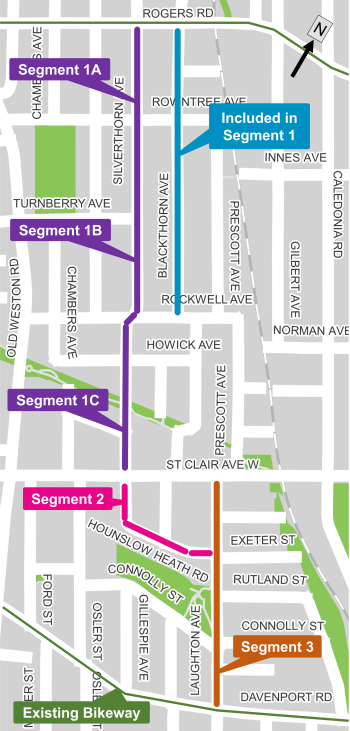
Public consultation for Silverthorn Cycling Connections Phase 1 took place in early 2024 and included proposed changes between Rogers Road and Davenport Road, presented in three segments:
Segment 1: Silverthorn Avenue – Rogers Road to St. Clair Avenue West
Segment 2: Hounslow Heath Road – St. Clair Avenue West to Laughton Avenue
Segment 3: Laughton Avenue – St. Clair Avenue West to Davenport Road
Phase 1 Approved Changes
The following design changes were approved for:
Segment 1: Silverthorn Avenue – Rogers Road to St. Clair Avenue West
Segment 2: Hounslow Heath Road – St. Clair Avenue West to Laughton Avenue
Segment 3: Laughton Avenue – St. Clair Avenue West to Davenport Road
View the public consultation information panels to see all design options that were proposed in Phase 1.
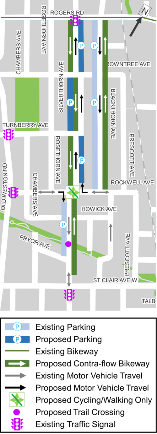
Approved changes for Segment 1
Segment 1 (Silverthorn Avenue from Rogers Road to St. Clair Avenue West)
Segment 1A – Silverthorn Avenue (Rogers Road to Rowntree Avenue)
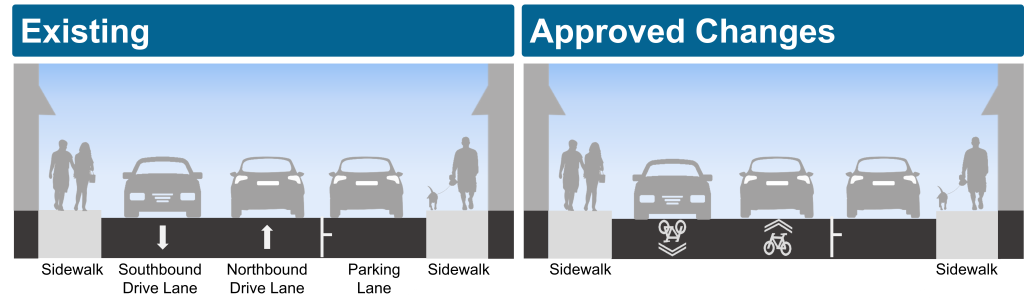
Convert two-way street to one-way northbound for motor vehicles
Add southbound contra-flow bicycle lane on west side of street
Add northbound wayfinding pavement markings and signage
Move parking to east side of street (estimated parking increase of four spaces)
Install bike signals, left-turn boxes and bike signal detection at Rogers Road intersection
Segment 1B – Silverthorn Avenue (Rowntree Avenue to Rockwell Avenue)
Convert one-way southbound vehicle lane to one-way northbound
Add southbound contra-flow bicycle lane on west side of street
Add northbound wayfinding pavement markings and signage
Parking stays on the west side from Rowntree Avenue to Turnberry Avenue (no change to total parking spaces)
Parking moves to the east side from Turnberry Avenue to Rockwell Avenue (no change to total parking spaces)
Segment 1C – Silverthorn Avenue (Rockwell Avenue to St. Clair Avenue West)
Add northbound contra-flow bicycle lane on east side of street
Add southbound wayfinding pavement markings and signage
Add a trail crossing at S.A.D.R.A Park
Parking stays on west side of street (estimated parking reduction of one space at planned trail crossing)
Road Resurfacing will be occurring on Silverthorn Avenue from Rockwell Avenue to St. Clair Avenue West
Silverthorn Avenue and Rockwell Avenue intersection:
Reduce intersection curb radii
Install a traffic diverter, creating a cycling and pedestrian only block with a diverter on Rockwell Avenue
Motor vehicle drivers traveling on Rockwell Avenue towards Silverthorn Avenue will be required to turn right at the intersection
Add crossing opportunities for pedestrians at all corners and in the center
Add new trees in green space
Maintain emergency vehicle access
Blackthorn Avenue (Rogers Road to Rowntree Avenue)
Convert two-way vehicle lanes to one-way southbound
Add northbound contra-flow bicycle lane on east side of street
Add southbound wayfinding pavement markings and signage
Make parking permanent on the west side (estimated parking reduction of one space)
Blackthorn Avenue (Rowntree Avenue to Rockwell Avenue)
Convert one-way northbound vehicle lane to one-way southbound
Add northbound contra-flow bicycle lane on east side of street
Add southbound wayfinding pavement markings and signage
No change to existing parking
Segment 2 – Hounslow Heath Road (St. Clair Avenue West to Laughton Avenue)
Wayfinding pavement markings and signage proposed for northbound and southbound lanes where people cycling and driving share the roadway
No change to existing motor vehicle lanes or parking
Segment 3 – Laughton Avenue (St. Clair Avenue West to Davenport Road)
Add northbound and southbound wayfinding pavement markings and signage
No change to existing motor vehicle lanes or parking
Public Consultation
Public consultation on Phase 1 took place in early 2024. The public consultation report (linked below) provides a detailed summary of all activities that took place, proposed changes and feedback received.
Phase 2 consultation (Rogers Road to Eglinton Avenue West) is expected to take place after the Fairbank Silverthorn Storm Trunk Sewer System work in the area is complete.
More information about Phase 2 public consultation will be listed here and sent to the project contact list in advance.
Monitoring and Evaluation
The City monitors and reports on projects in ways that are specific to each project context and users. Additionally, it takes time for people to adjust their travel habits to the changes.
For the Silverthorn Cycling Connections project the City will do the following within the first year following the installation:
Observe new travel behaviour
Conduct new traffic and speed counts on Silverthorn Avenue and connecting streets in the neighbourhood
Monitor traffic volumes on nearby streets
Conduct counts of people cycling
Continue to collect, record and respond to public feedback
Review any issues that are identified and proceed with upgrades where needed such as adjustment to traffic signal infrastructure and signal timing; changing pavement markings, curbs and bollards; and other adjustments.
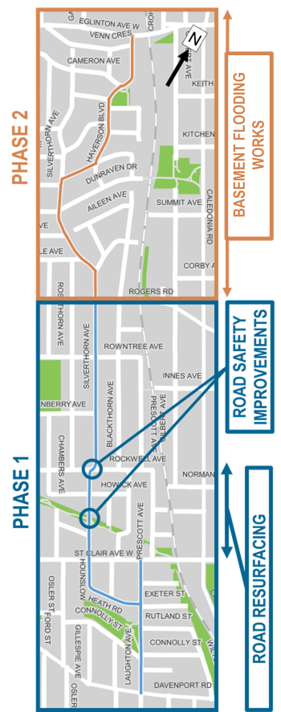 This project area includes two phases: