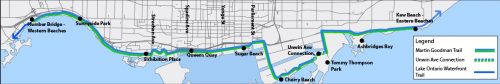
The Martin Goodman Trail (MGT) is part of a larger network of over 300 km of trails within the City of Toronto.

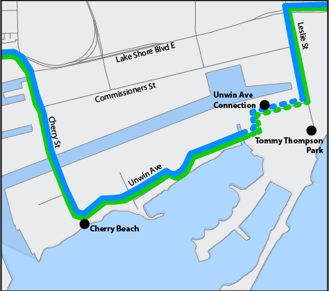
The Unwin Avenue section of the MGT, completed in 2019, filled in a missing link to complete a 20+ km trail along Toronto’s waterfront from the western to the eastern beaches.

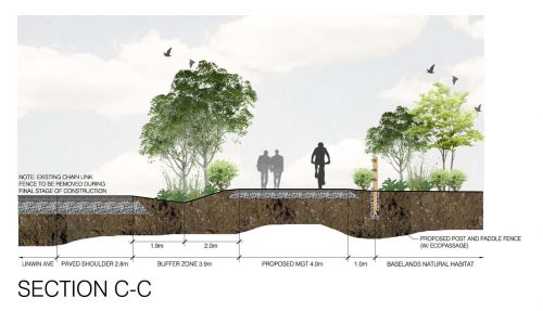
This connection was identified in the Baselands Trail Master Plan in April, 2015, and as part of Toronto’s 2016 Ten Year Cycling Network Plan. This trail connection provides a safe and accessible route for trail users.


Toronto Waterfront Trail Network Map
Toronto Trail Map at Unwin

Trail Requirements

  • Length: 740 metres
  • Width: 4.1 metres
  • Buffer: 3.9 – 17.15 metres
  • Material: Asphalt Surface
  • Slope: 5% maximum (1 in 20)
Unwin Avenue Connection Martin Goodman Trail proposed alignment
Unwin Avenue Martin Goodman Trail Proposed Cross Section A-A
Unwin Avenue Martin Goodman Trail Proposed Cross Section C-C

Functional Considerations

  • Trail User Safety is addressed by moving the alignment south of Unwin Ave. into the Baselands, a minimum distance of 3.9 metres from the paved shoulder of Unwin Ave.
  • Trail design adheres to the Accessibility of Ontarians with Disability Act (AODA) minimum standards
  • Trail design follows the Toronto Multi-use Trail Guidelines
  • Stormwater is addressed through raising the trail above existing grade, installing culverts where necessary and addition of bioswales

Environmental Considerations

  • Mature Cottonwood trees are avoided wherever possible
  • A barrier fence installed along the entire length of the trail to maintain Tommy Thompsons Park’s dog-free status and to deter trail users from establishing ad-hoc trails
  • Eco-passages spaced every 20 metres to allow for movement of wildlife
  • Disturbed areas will be restored following sustainable, natural landscape principles and best management practices
  • Habitat opportunities will be enhanced in disturbed areas, wherever possible
  • Bird nesting surveys were completed prior to any implementation of construction works to ensure migratory bird breeding is not impacted

Trail Crossings and Amenities

  • Features include pavement markings, warning signs, vehicle stop signs and painted stop bars to identify how cyclists and pedestrians can safely cross the two driveways into the Tommy Thompson Park parking lot (Figure 1)
  • All features, signage and treatments follow the City of Toronto Multi-Use Trail Guidelines (2015)
  • A permanent crossing similar to Figure 2 (left) is located at the west driveway into the Tommy Thompson Parking lot
  • A resting node with benches is located east of the crossing at Outer Harbour Marine Road (Figure 3)
  • Post and paddle fencing provide a barrier along the south of the trail (Figure 4)
Figure 1 Proposed concept design of temporary and permanent trail crossings


Figure 2 Example of asphalt treatment at Outer Harbour Marina Road and Unwin Avenue
Figure 3 Example of similar resting area and benches
Figure 4 Example of type of barrier fence along south side of trail