On behalf of the City of Toronto, Metrolinx will be building the West Toronto Railpath Extension.
Construction is planned to begin in 2026.
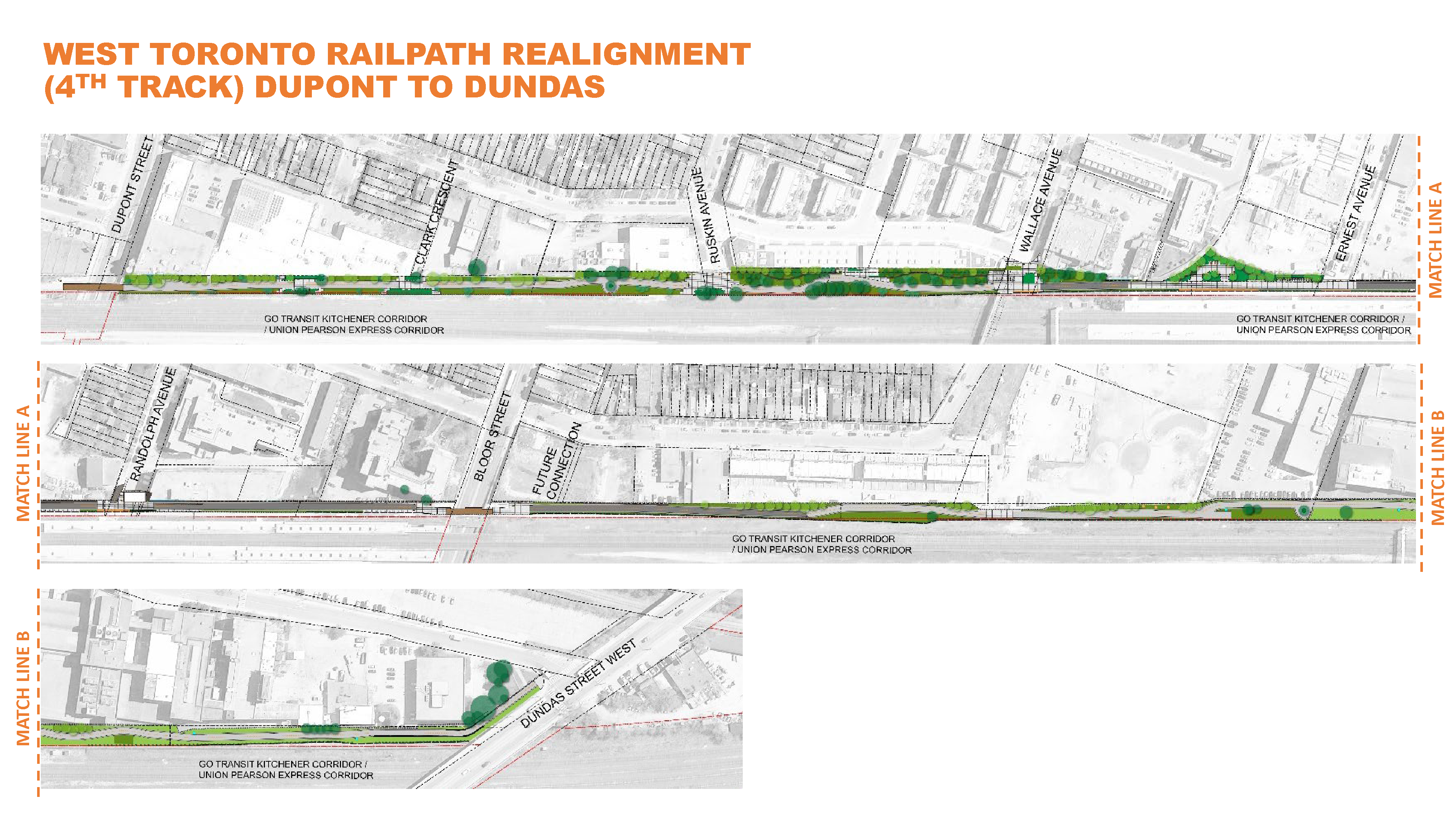
To accommodate the Bloor GO/UP Station Improvements Project, Metrolinx must realign the Railpath further east. A phased approach to construction is in place, closing only certain segments of the Railpath at a time, while maintaining access to preserve the community’s ability to use the Railpath where possible.
Learn more by accessing the West Toronto Railpath Realignment Segments Map.
Last Updated: May 11, 2026. Dates are estimates and subject to change.
Please visit Metrolinx’s Kitchener Line GO Expansion page to learn more.
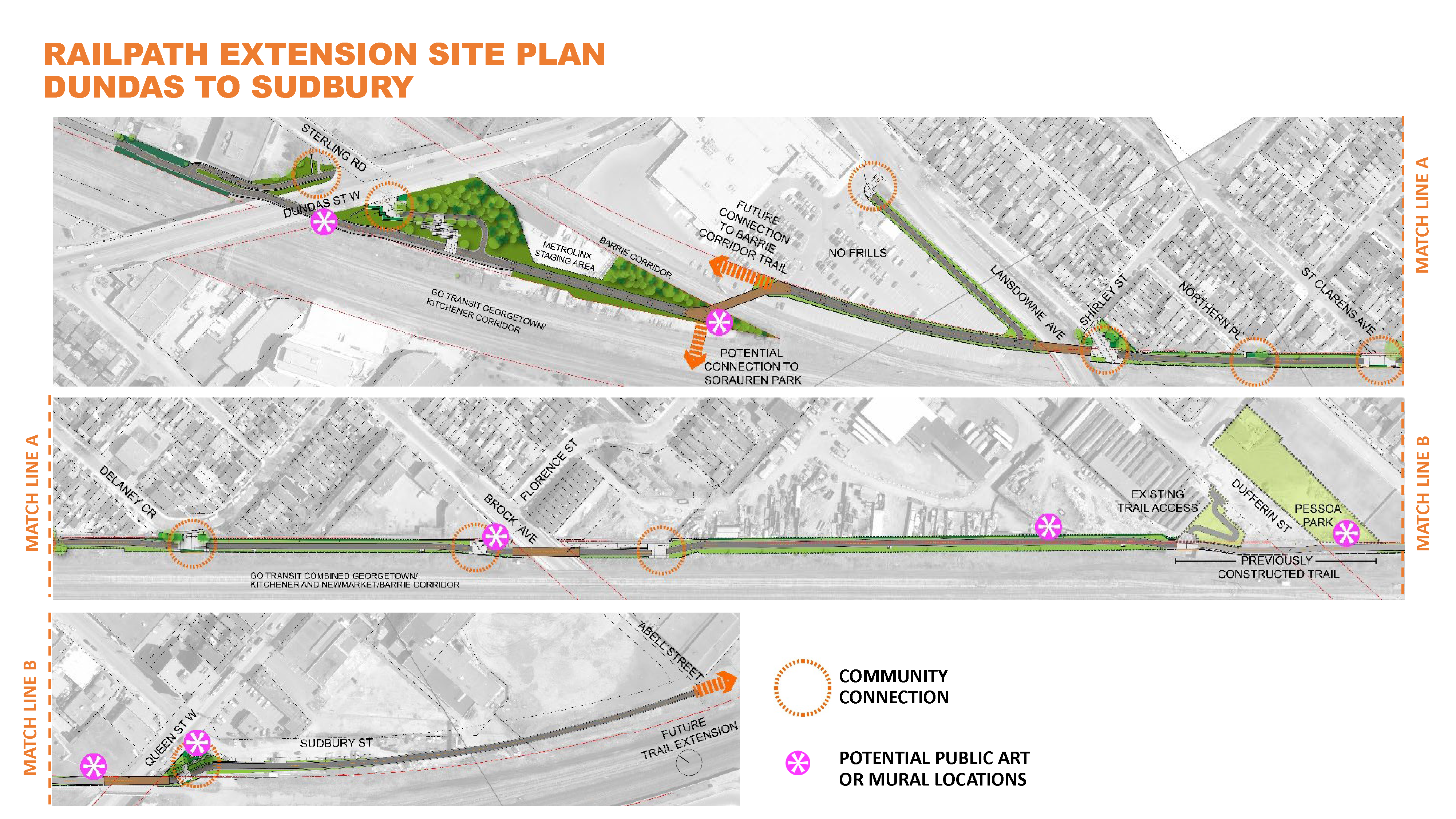
A new multi-use trail will be aligned in the rail corridor from the Dundas Street Bridge to Queen Street West (east side of the railway corridor) and adjacent to the rail corridor from Queen Street West to Abell Street.
South of Queen Street West, the lands in the rail corridor are more constrained due to Metrolinx’s railway track expansion plan and, as a result, a multi-use trail will be located within the municipal road right-of-way.
Given the lack of space within the rail corridor, technical issues and impacts to neighbouring properties, more consultation and study is needed to find a solution that lessens impacts and balances different interests.
| Time | Progress | Events |
|---|---|---|
| 2008 | Completion of the first phase of West Toronto Railpath | |
| 2012 | The City adopts the Bikeway Trails Implementation Plan and recommends an Environmental Assessment (EA) to study a preferred route to extend the West Toronto Railpath south | |
| 2016 | Completion of the EA report | 30-day review period |
| 2018 |
|
|
| 2019 |
|
|
| Early to Mid-2020 | Completion of design and construction documents | |
| 2020-2022 | City to obtain properties | |
| 2025 | The project team to work with property owners who have illegal encroachments on railpath lands that directly conflict with the project to remove or relocate the items | |
| 2026 | Construction proposed to start |
The West Toronto Railpath follows the trade route that Indigenous people would take from the Davenport Trail to the receding Lake Iroquois, following Roncesvalles and following the contours of the land. This route was later used as the path of a railway that started in 1871.
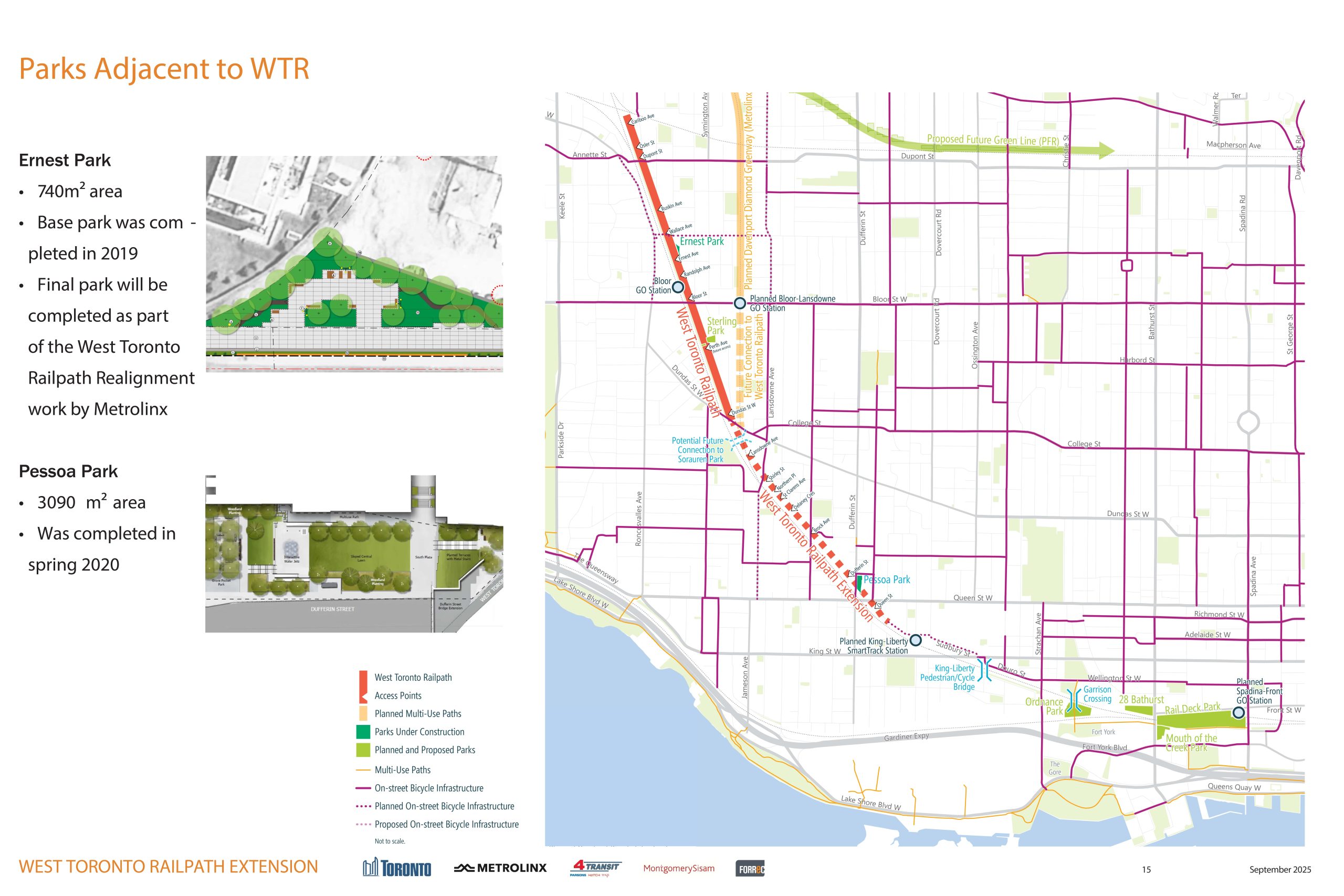
The first phase of the West Toronto Railpath from Cariboo Avenue (just north of Dupont) to the Dundas Street West Overpass along the rail corridor was completed in 2008. This section of Railpath received the 2011 City of Toronto Urban Design Award.
Read more about how the Kitchener GO Line expansion will result in the re-alignment and upgrades to the existing Railpath from Wallace Avenue to just south of Bloor Street West between 2022 and 2025.
In June 2012, City Council adopted the multi-year Bikeway Trails Implementation Plan and new trail connection priorities. These priorities included a recommendation for an environmental assessment study to develop a preferred route to extend the West Toronto Railpath south from Dundas Street West to Strachan Avenue.
The City completed its Environmental Assessment study in 2016 for extending the West Toronto Railpath from Sterling Avenue (at Dundas Street West), along the Kitchener GO rail corridor to just south of Queen Street West (at Abell Street).
This study followed a Municipal Class Environmental Assessment (Class EA) Schedule ‘C’ process, which included identifying the problem/opportunity, developing and evaluating a reasonable range of alternative solutions, and providing opportunities for public input.
The study determined:
On May 17, 2016, the Minister of the Ministry of Environment, Conservation and Parks approved the West Toronto Railpath Extension Environmental Assessment study.
To view the report, contact Maogosha Pyjor at 416-338-2850 or email westrailpath@toronto.ca.
Since completing the Railpath in 2009, lessons learned, included:
Through community and stakeholder consultation events in 2018 and 2019, feedback for the design of the new extension included:
All feedback from public meetings to individual meetings with communities immediately adjacent to the new Railpath Extension were noted and efforts have been made to incorporate these comments into the design.
The detailed design phase has been carried out jointly by the City of Toronto and Metrolinx.
The completed design plan guides the future construction of the Railpath Extension multi-use trail, and includes detailed plans and drawings for:
The detailed design phase was coordinated with other projects planned in the area, including:
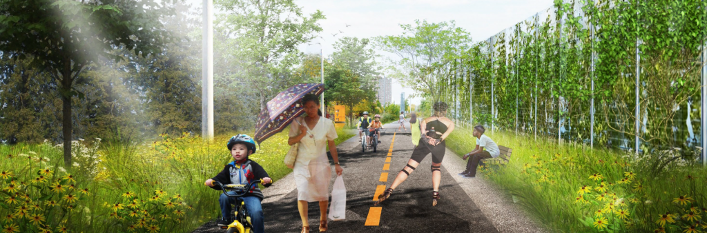
Multi-use trails are actively enjoyed by a wide range of users and are generally considered an attractive neighbourhood amenity. Trails provide a space for interaction with neighbours and increase access for people to discover natural, cultural and heritage places in the city.
Public places that are actively used by residents are generally regarded as safer and more comfortable for all ages – the most effective crime prevention approach is to encourage a high level of activity along the trail system. Trails support the opportunity for physical activity through walking, running, rollerblading and cycling which is in tune with the City’s public health objective to encourage physical activity to improve the health of Torontonians.
Building high-quality trails with accessible infrastructure promotes social equity and supports the Official Plan for the City, which identifies sustainable transportation as a priority, with a goal to make walking, cycling and public transit increasingly attractive alternatives to single-occupancy vehicle use.
The Railpath will be designed as a multi-use facility and will function as a shared space between a variety of different users including people who cycle, walk and/or roll etc.
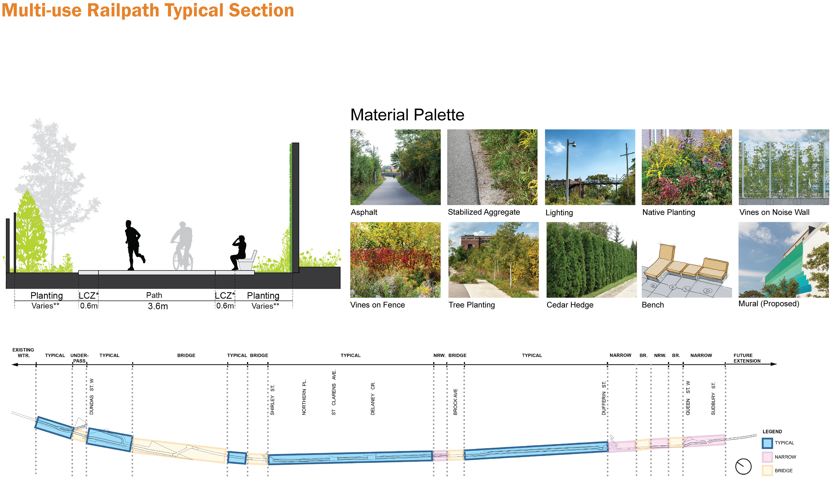
Generally, the paved portion of the trail will be 3.6 m with a 0.6 m wide buffer that is clear of furniture, light poles, etc. There will also be a furniture zone and planting on the other side.
The design principles that will be implemented include
The entire section between Dundas Street West and Dupont Street will be replanted due to the realignment of the railway tracks. Therefore, the unique ecology in the Railpath corridor will be enhanced, both in the Extension south of Dundas West and the current Railpath north of Dundas Street West.
Community connection points from neighbourhood streets to the West Toronto Railpath Extension will offer opportunities for people of all ages and abilities to access the Railpath and enjoy the space for recreation, art, active transportation and more green space. These connection points may also provide community stewardship (i.e. gardening) and programming opportunities (i.e. shared community space).
There will be four new pedestrian-cycle bridges as part of the route including bridges over the
As part of the Railpath Extension, a pedestrian-cycle bridge was built over Dufferin Street in 2016.
The Railpath is maintained by the City of Toronto in the winter, which includes plowing, salting and litter picking. Transportation Services maintains the bridges and Waste Management empties the receptacles year-round.
The City will continue to encourage safe and appropriate use of the Railpath Extension by including signs and pavement markings. Further efforts, such as public education campaigns and increased by-law enforcement, are beyond the scope of this conceptual design project, but recommendations for such efforts will be shared with appropriate City divisions.
The detailed design for the West Toronto Railpath Extension is funded jointly by the Federal Government and the City of Toronto through the Public Transit Infrastructure Fund (PTIF). The City is continuing to explore opportunities for funding construction in collaboration with other levels of government.
A public meeting was held on February 26, 2020, at the Museum of Contemporary Art (MOCA) and was attended by 263 people.
A presentation was given to review the final design elements (i.e. bridges, landscaping and community connections) and to give more details about the project and timelines. A question and answer period followed the presentation. The public feedback period ended on March 12, 2020.
The material shown at the event included:
Read the Public Event #2 Feedback Summary for more details of the event.
A public drop-in event was held on September 13, 2018, and was attended by 108 people. The information below was displayed highlighted the different design elements being considered:
A total of 44 feedback forms were received from attendees and 322 people completed the online feedback form.
Read the Public Event #1 Feedback Summary for more details of the event.
The project team met key stakeholders on June 25, 2019, in order to provide a project update and discuss various topics including landscape architecture, bridge structures, community connections and public art.
See the Stakeholder Meeting #2 Presentation and Stakeholder Meeting #2 Feedback Summary for more details.
The project team met with key stakeholder groups on May 14, 2018. These groups were highly involved in the Environmental Assessment study and were engaged to share their priorities moving into the next design phase of the project.
Read the Stakeholder Meeting #1 Summary for more details.
Community meetings took place on April 15, 16 and 17, 2019, to hear from residents with planned connections points to the Railpath from their streets including Delaney Crescent, St. Clarens Avenue, Northern Place and Shirley Street.
Read the Community Connections Meetings Feedback Summary for more details.
 Under the Public Transit Infrastructure Fund (PTIF) – Phase 1, the Government of Canada is investing up to $1.45 million for the West Toronto Railpath Extension Design project. The City of Toronto is matching this funding contribution.