From May 2, 2023 to late summer 2024, the Lower Don Trail will be closed from Pottery Road to Bala Underpass at Corktown Common for Phase 2 construction. This includes the stairs from the Riverdale pedestrian bridge and Queen Street bridge. Visit the Project Updates section for more information.

The City is preparing to study the Lower Don area as a follow-up to the 2013 Lower Don Trail Master Plan. The updated plan will provide a framework that will reflect the guiding values and guiding principles for recreation planning in the Lower Don Valley. It will also identify improvements in this area that are consistent with these guiding values. This plan is proposed to be collaborative, to enable Indigenous rights and treaty holders to lead Indigenous public art and Indigenous stewardship and programming in the Lower Don River valley lands.

While we aim to provide fully accessible content, there is no text alternative available for some of the content on this site. If you require alternate formats or need assistance understanding our maps, drawings, or any other content, please contact Ruthanne Henry at 416-395-0142.


November 2023

Phase 2 Construction Update

Phase 2 project is delayed, and the completion date is anticipated to be late summer 2024. The project site is complex, narrow, and located between Don River and a rail corridor, which has resulted in some challenges with getting materials and equipment in and out of the site. Additionally, a section of the site experienced erosion from the nearby river (a geotechnical review for a solution is underway) and some of the required permitting and approvals from other infrastructure located nearby took longer than anticipated.

July/August 2023

Phase 2 Construction Update

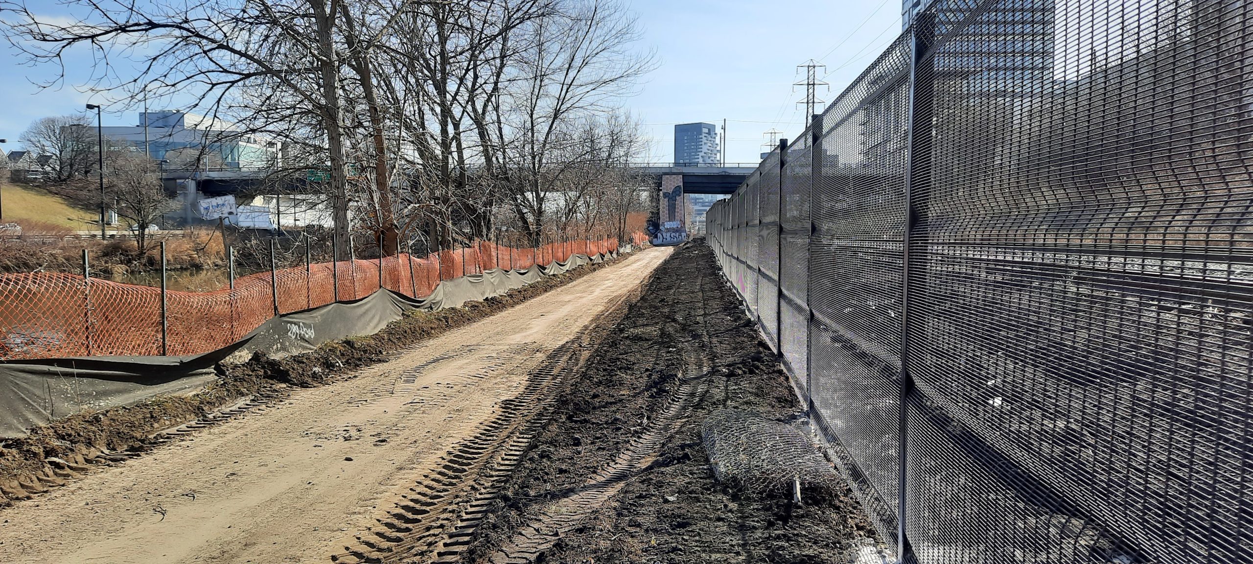
Construction is active on the Lower Don Trail. All trees permitted for removal have been removed with some exceptions. Existing site features including asphalt pavement, Metrolinx fences at the railway side, and pedestrian guardrails at the riverside (for safe travelling) have been removed in several sections throughout the entire site. Heavy construction equipment vehicles travel across the site. The construction contractor will start excavating the foundations and preparing the site for slope path construction at the Riverdale Bridge area and staircase construction at Dundas Bridge.

The trail should not be used by the public at all, as it is unsafe.

The City closed off the main entries to the Lower Don Trail phase 2 site and these entries are at Pottery Road, Riverdale Bridge staircase, Queen Bridge staircase and Corktown entry.  Additional barriers are also located within the closed area at the Bellville Underpass, and the red pedestrian bridge. The trail closure is intended for pedestrians and cyclists. The City has been monitoring and reinforcing the closures daily.

Bayview Multi-use Trail is the alternate trail for everyone during Lower Don Trail Phase 2 construction.

Excavators working to remove existing site items at the south side of Riverdale Pedestrian Bridge
Work in progress at Dundas Bridge area for new staircase installation

June 2023

Phase 2 Construction Update

Trail construction has started with the early stages of site preparation work, which is taking slightly longer than anticipated due to the irregular topography of the site and approvals and inspection for the permit conditions. The trail was closed in May so that the contractor could access and set up the staging area and set up the tree protection and sediment control required for the permits.  Due to the few entry/exit locations along the trail, 4 km of the trail is closed to the public to allow for the contractors to start work in an area that encompasses both south and north of the mid-access point (Riverdale Parks East and West into the trail and vice versa).  While it is possible to briefly open the very small area at the south end of the trail, from Queen Street to Corktown, the closure would be hidden from the entrance and confusing as pedestrians and cyclists would need to turn around and detour. Additionally, construction will move to this area in the near future. In mid-June, other construction activities like excavation will start and create unsafe conditions, even during the weekends when construction work has paused.

The Bayview Multi-use Trail is available as an alternative route for the entire distance of the closure and is parallel to the trail.

The trail under construction showing a west muddy trail with construction fencing on the left side separating the trail from the mature trees and greenery along the perimeter.
The trail under construction showing a wet muddy trail with caution tape and construction fencing on the left side and construction workers in the background.

April 2023

Phase 2 Construction

From May 2, 2023 to summer 2024, the Lower Don Trail will be closed from Pottery Road to Bala Underpass at to Corktown Common, including the Riverdale pedestrian bridge and Queen Street bridge stairs, for Phase 2 construction. Signs with a detour map are posted at all trail access points. The Bayview multi-use trail, west of the Metrolinx Railway, is available as an alternative route.

The pedestrian bridge connecting Riverdale Park West and Riverdale Park East is open to the public but will not provide access to the Lower Don Trail during construction.

A map of the Lower Don Trail and surrounding area, showing the areas impacted by phase 2 construction for the trail improvements. The multi-use trail running predominantly north-south is shown in orange, a non-entry symbol shows the trail entry points that are closed during construction, a red lined with hash marks shows the closed multi-use trail, and the bike lane or cycle track is shown with a blue line.

May 2022

Phase 2 Construction Delayed

The start of the Lower Don Trail Improvements Phase 2 is currently delayed due to the need to re-tender and obtain final permits required by the new contractor. This includes trail improvements along the 2 km section of trail from Belleville Underpass to Corktown Common, as well as two significant infrastructure projects to improve access to the trail at the Dundas Bridge and the Riverdale Pedestrian Bridge.

During the improvements, the Lower Don Trail will be closed from Pottery Road to Corktown Common, including the Riverdale pedestrian bridge and Queen Street bridge stairs. Advance signage with detour maps will be located online and on the trail.

Trail construction is anticipated to be complete with the trail open for spring 2024.

March 2020

Due to a number of factors, including shifting priorities and policy updates, The Lower Don Trail Master Plan Update was put on hold in 2020. 

The new policy and initiatives that will influence the future planning for this area include: 

September 2019

Public Meeting: Master Plan Update

A meeting took place on September 17, 2019 to present the public with information on the Lower Don Trail Master Plan update.

July 2018

Stakeholder Information Meeting

On July 19, 2018, a meeting took place at Riverdale Library and where several stakeholders provided input. The design to date was well received and comments received are helping the project team move further into detailed design. Comments to the project team can best be integrated into the design prior to August 20, 2018.

Design Summary

A new ramp is planned that will provide easier access to the Lower Don Trail from the Riverdale pedestrian bridge. The ramp will extend off the north side of the bridge, with a switch-back down to the trail. It will complement the existing staircase on the south side of the bridge.

The position of the ramp is between the rail (Bala Metrolinx line) and the Don River.  Based on the constrained site width (between rail and river) there is only one turn to the switch back. The switchback is in the northward direction and has a vista lookout at the turn around point. The existing stairs will remain (south of the bridge).

The sloped path gradient is consistent with the accessibility guidelines for paths of a max five per cent. There is a resting area, with an accessible bench at the turnaround.

The ramp will meet existing grade and integrate with the adjacent four metre wide trail in the existing location.

The width of the ramp is proposed to be a minimum of three metre and significantly wider at the turn around (six plus metres). The maximum height of the ramp where it connects to the bridge is approximately nine metres, and the distance between the access from the bridge and the outward edge of the turnaround is 113 metres.

The materials to be used will be similar to those used in recently constructed projects in the valley. These are called the Lower Don Valley Palette:

  • weathering steel
  • reclaimed timber
  • native perennial plantings
  • stone
  • galvanized steel

February 2017

Community Disability steering Committee Meeting

On February 15, 2017, a special meeting was held with the Community Disability Steering Committee.

June 2015

Site Visit

A site visit took place on June 2, 2015 at Riverdale Bridge.

May 2014

Public Meeting

On May 27, 2014, a public meeting took place at St Simon the Apostle Church at 525 Bloor St. E.

Project Partner and Stakeholder Consultation

Project partners provided the following feedback:

Toronto Region Conservation Authority (TRCA)
  • minimize overall site disturbance and limit amount of new features within the floodplain
  • minimize filling within the floodplain
  • avoid impacts to existing natural features
  • restore/ improve existing habitat
  • locate new structures away from river banks
  • north Switchback Option preferred
Metrolinx
  • standard Transport Canada Railway Clearances
  • potential derail containment structure or barrier (Pier Protection)
  • consider future electrification
City Maintenance and Operations
  • accessible route from West side would require future phased connections/ impact on park programming
  • east Side accessibility to be implemented with this project
  • ongoing maintenance requirements (no winter maintenance)
Stakeholders,  including the Toronto Accessibility Advisory Committee, provided the following feedback:
  • viewing interest, rest areas and seating desired
  • signage important
  • turning radius considerations
  • sightlines and views (especially for people in wheelchairs)
  • surface texture differentiation (thermaplast/paving textures)
  • phased approach to larger accessible city destinations

The ramp needs to service as many users as possible, including:

  • pedestrians
  • cyclists
  • cyclist with trailers
  • people who use wheelchairs
  • people who use walkers or canes
  • people who use recumbent bikes and hand pedals
  • people walking dogs
  • caregivers with strollers
  • people who are visually impaired

The following projects are currently underway.

Riverdale Park East Top of Bank Improvements

  • Location: Top of the bank in Riverdale Park East, adjacent to Broadview Avenue.
  • Status: Design procurement.

The top of bank in Riverdale Park East is often visited year-round for its iconic sunset view and popular tobogganing hill. The viewing area at the top can be expanded and site furniture can be added.

Cudmore Creek Wetland and Trailhead

  • Location: Intersection of Pottery Road and Bayview Avenue, adjacent to the Don River.
  • Status: Designed and funded. Construction anticipated to start 2022.

The entrance to the Crothers Woods Trail at Pottery Road, east of Bayview Avenue, is sometimes used as an informal parking lot. However, the area often floods and could be naturalized as wetland. Add a Crothers Woods trail kiosk and clear signage.

Don Valley Brick Works Park: North Slope Interpretive Feature

  • Location: North side of Don Valley Brick Works site.
  • Status: Study is underway.

Informal trails run around the top of the north face of the Don Valley Brick Works (the perimeter of the former quarry). Because of the risk of erosion and damage to the Environmentally Sensitive Area (ESA), use is discouraged and no formal trails are possible. Study additional measures to discourage access to this area by users seeking views or shortcuts.

Redesign and Reconstruction of Governor’s Bridge Lookout

  • Location: Peak at Don Valley Brick Works site.
  • Status: Designed and partially funded.

Governor’s Monument is one of the highest profile sites around the Brick Works, attracting hikers and sightseers because of its views. Repair to resolve current drainage problems and function as a public gathering space, potentially accommodating public art.

Formalize Linkage Trail and Upgrade Stairway to Meet Accessible Standards, From Pottery Road Slope to Todmorden Mills

  • Location: South side of Pottery Road within Todmorden Mills site.
  • Status: Under construction, but not yet complete.

Currently a set of wooden steps link the Pottery Road trail to the rear of Todmorden Mills. The stairs serve an important connection between Todmorden Mills and the neighbourhoods north of the Danforth.

Formalize Trail through Wellesley Park and Upgrade Stairway to Meet Accessible Standards

  • Location: Wellesley Park, between the end of Wellesley Street East and Rosedale Valley Road.
  • Status: In design.

The existing stairway from Wellesley Park to the Rosedale Valley Road/Bayview Avenue intersection represents a key portal into the valley. However, it is not connected to any sidewalks or trails at the upper end of the slope and has low visibility. The stairway itself needs to have its accessibility features improved.

Lower Don Sloping Path

  • Location: The existing Riverdale Pedestrian Bridge and the Lower Don Trail.
  • Status: Designed but awaiting construction.

Part of Phase 2 Lower Don Trail Improvements. A sloping path (ramp) providing a more accessible pedestrian and cycle connection from the Riverdale Pedestrian Bridge the Lower Don Trail below.

Dundas Staircase to Lower Don Trail

  • Location: The existing Dundas bridge abutment on the west side of the river.
  • Status: Designed but awaiting construction.

Part of Phase 2 Lower Don Trail Improvements. A staircase to connect with the trail and meet accessibility standards.

Reconstruction of Lower Don Trail and Widening

  • Location: The Lower Don Trail from the red pedestrian bridge to Don Landing.
  • Status: Designed but awaiting construction.

Part of Phase 2 Lower Don Trail Improvements. Wherever possible increase width of the trail.

The following projects are not yet funded and may require additional planning and vetting through consultation and engagement. Excluded from this list are mid- and long-term future projects that would require a more detailed review during a future update to the Master Plan.

Formalize Connection through Cullen Bryant Park

Location: Cullen Bryant Park on Taylor Drive, north of O’Connor Drive

The current steps from Cullen Bryant Park to the Taylor Creek Trail are located at the rear of the park and not visible from the street.

Coxwell Ravine Trails and Public Washrooms

Location: Coxwell Ravine Park, between the Don Valley Parkway and O’Connor Drive.

The ongoing reconfiguration and natural restoration of the Coxwell Ravine Park and the removal of its parking lot will provide opportunities for several improvements.

Redesign of Forks Node

Location: The Forks area, where Don Mills Road crosses the Don River.

When viewed at the city-wide scale, the Forks area is one of the most important nodes in the trail system. With the completion of the East Don Trail and Ridge Train, five major trails will converge at the Forks (where the Don River splits in three). There is also car access and a recently-reconstructed parking lot in the area.

Reconstruction of the node area is already being studied by the City, which has produced preliminary designs.

Improve Connection from Beechwood Drive

Location: The end of Beechwood Drive.

The relative scarcity of entry points to the Lower Don Trail system, especially north of Pottery Road, means that each portal needs careful design to welcome visitors. One of the least visible portals to the trail occurs where Beechwood Drive descends into the valley and under the Don Valley Parkway, also providing access to the Toronto Police Dog Services Building. Improvements for Beechwood Drive and the area could include beautification, rest stops and an additional public parking facility. In addition to this, a possible future relocation of the Toronto Police Dog Services Building would open new opportunities for Parks facilities in a rare site within the valley that is already fully serviced with water, sewers and electricity.

Upgrade Stair Connection from Redway Road and Improve Linkages into the Crothers/Ridge Trail System

Location: Between Redway Road and the North Toronto Wastewater Treatment Plant.

The current design of the stairway from Redway Road to the rear of the North Toronto Wastewater Treatment Plant is basic and lacking in accessibility features. Furthermore, there are no formal trail connections from the base of the stairway into the planned Ridge Trail system.

Feasibility Study for Remediation of, and Connections to, Snow-Drop Area

Location: Proposed “Snow-Drop Park” site, between the Belleville rail corridor, the Don River and the Bayview On-Ramp.

One of the landmark opportunities in the Don Valley is the creation of a new public space, dubbed Snow Drop Park, on the former snow dump site south of the Bayview On-Ramp. The space, approximately 4.5 hectares, is by far the largest opportunity to add new parkland in the vicinity of the Lower Don Trail. Bordered by the railway on one side, the Bayview on-ramp on another, and the Don River on two sides, it is inaccessible by foot or bicycle. Vehicular access can occur from the Bayview on-ramp. The first steps is to study the feasibility of remediating the space, which likely still harbours pollutants from snow deposited there and from its earlier history as an industrial site, as well as opportunities for accessing it. Following remediation, considerable design work and possibly naturalization will need to happen.

Chester Springs Ecological Enhancements and Lookout

Location: Chester Springs Marsh, between the Don River and Lower Don Trail, south of the Prince Edward Viaduct.

The City has already conducted a study into potential ecological enhancements and a lookout space at Chester Springs (a bend in the river a little south of the Prince Edward Viaduct), although implementation has not yet been approved.

Restoration of Riverdale Farm Ponds/Remnants of Former Zoo with New Historic Interpretation

Location: The lower portion of the Riverdale Farm site, adjacent to the end of historic Winchester Street.

The less-visited lower portion of the Riverdale Farm site includes a number of ponds, some of which require natural restoration. Remnants of the former Riverdale Zoo are still visible in this area. There is an opportunity to carry out restoration work, while also improving trail accessibility and adding historic interpretation.

Consider Vertical Realignment of Portions of Lower Don Trail to Prevent Mud and Silt Build-up in the Spring

Location: The Lower Don Trail through the length of the Narrows.

Mud and silt build-up are chronic problems in certain segments of the trail, particularly in the Narrows. This typically occurs in the spring following serious flooding or ice jams.

Potential Upgrades to Helliwell Wetlands

Location: Along the Lower Don Trail, just south of the Bayview/DVP On-ramps, just west of the Metrolinx line.

Helliwell Hill Wetland is a wetland restoration project located between the Lower Don Trail and the DVP/Metrolinx tracks. This restoration project was initiated in 1997 by the City of Toronto and the Task Force to Bring Back the Don, with the cooperation of TRCA. Since initial restoration efforts, the wetland is in need of upgrades to improve function, increase protection and improve the interpretation of the site within the landscape.

The following projects are now complete or on-going since the 2013 Master Plan, some with additional phases identified for consideration:

Cottonwood Flats Trails and Bird Habitat Protection

Location: Cottonwood Flats, between Don River and Don Valley Parkway

Don River Lookout Platform

Location: Adjacent to Don River, north of Pottery Road

Crothers Woods Kiosk Installations

Location: Crothers Woods, north of Bayview Avenue, west of Don River

Relocation and Widening of Forks Parking Lot, Separation of Bike Path

Location: The Forks area, where Don Mills Road crosses the Don River

Pottery Road Trail Bridge

Location: Pottery Road crossing of the Don River.

Bayview Avenue Multi-Use Trail

  • Location: Bayview Avenue, south of Pottery Road.  Extension Rosedale Valley to River Street
  • Status: Fully complete. There is a possible future opportunity to extend the trail north of Pottery Road.

Chorley Park to Beltline Trail Connection

Location: East side of Chorley Park.

Don Valley Brick Works Wayfinding/Interpretive Signage Program

Location: All along the Lower Don Trail.

Don Valley Brick Works Trail Improvements

Location: Don Valley Brick Works site.

Don Valley Brick Works Patio Reconstruction

Location: Don Valley Brick Works site.

Don Valley Park Inlet and Boardwalk

Location: Don Valley Brick Works site.

New Belleville Underpass

Location: Trail underpass below Belleville rail corridor.

Improvement to Rosedale Valley Road-Bayview Avenue Intersection

Location: Intersection of Rosedale Valley Road and Bayview Avenue.

Upgrades to Riverdale Park East Sports Facilities

Location: Northeastern corner of Riverdale Park East.

Riverdale Park East Wetland Expansion

Location: Northwest of Riverdale Park East.

Bala Underpass Painting

Location: Trail underpass below Bala rail corridor, adjacent to Corktown Common.

Temporary Public Art Installations/Performances

  • Location: Throughout the Lower Don area.
  • Status: Ongoing on a regular basis.

Spot Trail Repairs

  • Location: Throughout the Lower Don area.
  • Status: Ongoing on a regular basis.

Repaving Sections of the Trail

Location: From Pottery Road south to Belleville Underpass

Formalize Trail on East Side of Don Mills Road

  • Location: Along the east side of Don Mills Road, from the Belleville rail corridor to a point south of the Overlea/Gateway Boulevard intersection.
  • Status: Fully complete, except for the potential replacement of existing stairs with a ramp (currently being considered as a potential near-term future project).

Improve Connection from Thorncliffe Park Drive, Including Beautification, Rest Stops and Connections to Adjacent Trails

Location: Park driveway connecting Thorncliffe Park Drive to E.T. Seton Park.

Natural Surface Trail Improvements at Chorley Park Adjacent to New Switchback Trail

Location: Natural trail adjacent to hard surface switchback trail, on the east side of Chorley Park.