
The City of Toronto is conducting a series of Regeneration Area Studies to guide growth, investment and change in key areas across the city. These studies explore how transitioning lands could be revitalized with new housing, jobs, community services and public spaces. Our goal is to create complete, inclusive and resilient neighbourhoods that respond to local needs and properly integrate within the local area. Explore the studies underway and learn how you can get involved.
Regeneration Areas are a land use designation in Toronto’s Official Plan applied to sites where change is anticipated — often transitioning from employment uses to a mix of residential, commercial and community uses. Through a Regeneration Area Study, a comprehensive planning framework is recommended to City Council that ensures redevelopment is coordinated, supports complete communities including affordable housing and employment uses, and addresses matters like land use compatibility, infrastructure needs and environmental remediation before industrial lands are unlocked for other uses.
In 2020 the City completed a Municipal Comprehensive Review, a process that reviewed requests to convert lands from an Employment Areas designation to permit non-employment uses or to broaden permitted uses. As part of this conversion request process, the City received approximately 150 requests to convert lands designated Core Employment Areas or General Employment Areas to permit non-employment uses.
To learn more about the City’s Employment Areas, please watch this short video.
The conversion request process involved staff:
Based on their findings staff:
These studies are crucial for:
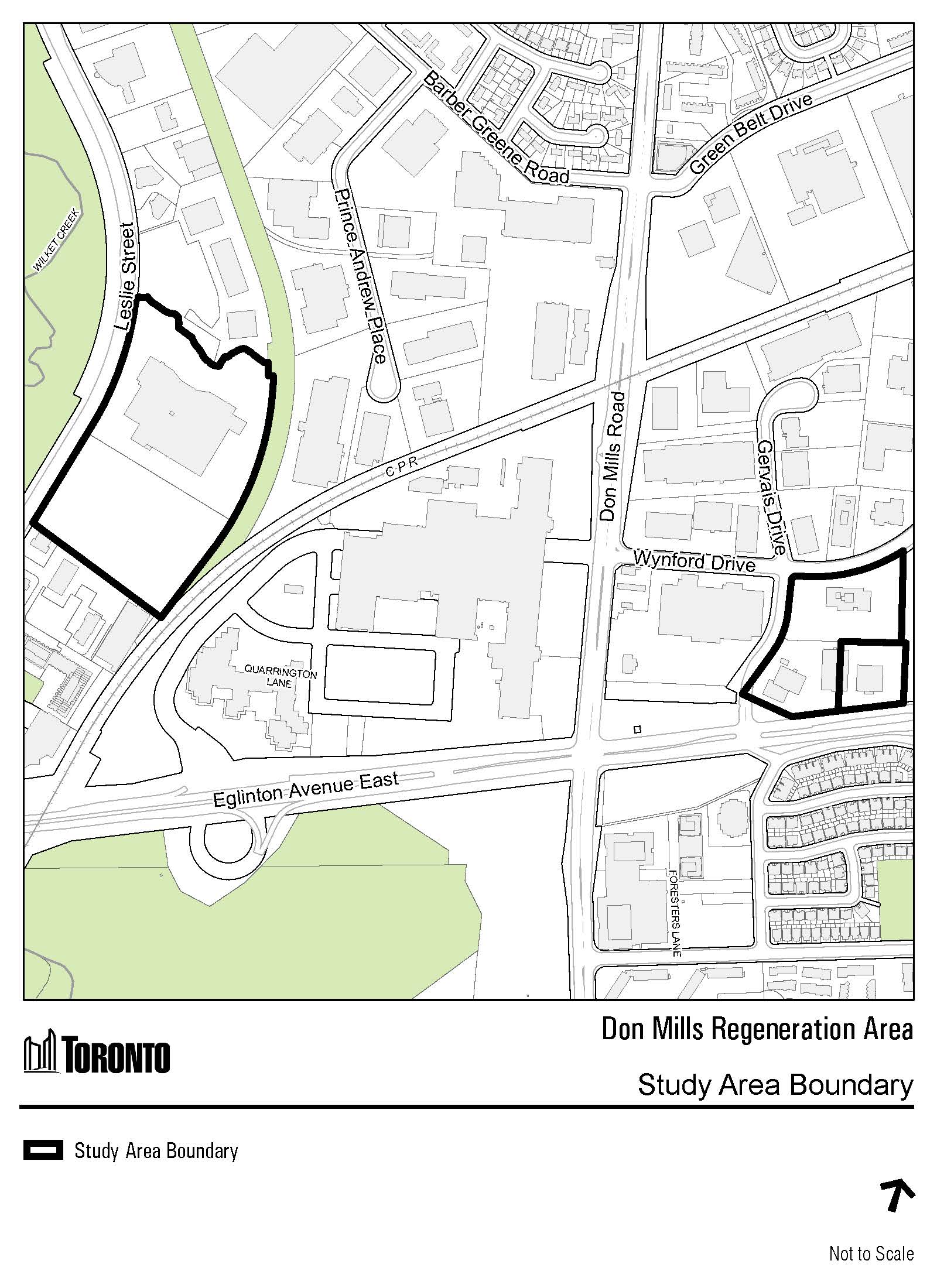
The Don Mills Regeneration Area Study will build on the Don Mills Crossing Secondary Plan and identify what the future policies for the lands should be as they evolve from employment uses to new mixed-use communities. The study will focus on land use, parks and open space, phasing, streets, community services and facilities and built form, resulting in a City-initiated amendment to the Official Plan that is tailored to the subject lands.
The subject lands were converted from General Employment land use designations to Regeneration Areas through Official Plan Amendment 653, which was approved by the Provincial Minister of Municipal Affairs and Housing in January 2025. The lands at 1200 Eglinton Avenue East were also converted to Regeneration Areas through a separate process. This resulted in Site and Area Specific Policies 828, 848, and 898 which set out the requirements for Regeneration Area Studies for the lands. The outcomes of the Don Mills Regeneration Area Studies will update or replace these Site and Area Specific Policies with policies to guide redevelopment of the lands.
The Don Mills Regeneration study area consists of the properties at 15 Gervais Drive, 39 Wynford Drive, 1121 and 1123 Leslie Street , and 1200 Eglinton Avenue East.
Item – 2023.PH5.3 – On July 19 and 20, 2023, City Council adopted Official Plan Amendment 653 which, among other matters, redesignates certain lands from Core Employment Areas or General Employment Areas as a result of conversion requests by property owners.
We have conducted 3 public engagement events. Please view all meeting materials and summaries below. The feedback received throughout the project will inform the final Staff Report and policies that will be presented to North York Community Council on May 26, 2026, which will include the Statutory Public Meeting, and City Council on June 24-26, 2026.
September 11, 2025
December 2, 2025
March 5, 2026
Jessica Krushnisky, Senior Planner
Strategic Initiatives Policy & Analysis
City Planning Division
Metro Hall
22nd Floor, 55 John St.
Toronto ON M5V 3C6
Telephone: 416-392-7215
Email: DonMillsPlanning@toronto.ca
City Planning collects your personal email address under the legal authority of the Planning Act, section 17(15); the City of Toronto Act, 2006, section 8; and Item 2023.PH5.3, City Council Decision 10, 11, 12, 13, as confirmed by the City of Toronto By-law 785-2023 and 822-2023. The information will be used to confirm and administer a subscription to electronic notifications regarding the Don Mills Regeneration Area Study specifically in promoting the project and providing updates about key milestones and public engagement opportunities. Questions about this collection can be directed to the Project Manager, Strategic Initiatives, Policy and Analysis, City Planning, Metro Hall, 22nd Floor, 55 John Street, Toronto, Ontario, M5V 3C6, or by telephone at 416-392-4524.
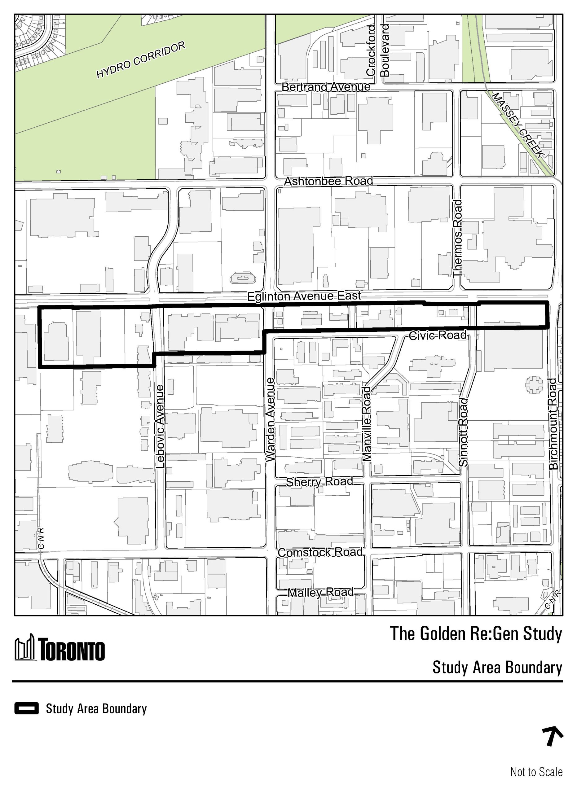
The Golden Re:Gen Study is a strategic update to the employment areas within the 2020 Golden Mile Secondary Plan. The study will set out a renewed vision for these lands which were converted from General Employment Areas to Regeneration Areas.
In 2017, the Golden Mile Secondary Plan Study was undertaken by the City of Toronto to develop a vision and comprehensive planning framework for the Golden Mile area. Subsequently, City Council adopted the Golden Mile Secondary Plan (Official Plan Amendment 499) and Urban Design Guidelines in October 2020. See the adopted final report and notice of adoption for more information. The Ontario Land Tribunal approved Official Plan Amendment 499 with modifications on December 13, 2024 (see the Tribunal Decision for more details).
In January 2025, the Minister approved the OPA 644 which included converting the General Employment Areas to Regeneration Areas through the last Municipal Comprehensive Review. The City of Toronto is undertaking a study which will set out a renewed vision for the Regeneration Area lands.
The Golden Re:Gen Study is approximately 11.75 hectares (29 acres) and consists of lands generally South of Eglinton Avenue East within the Golden Mile Secondary Plan, and East of 1891 Eglinton Avenue East to Birchmount Road (excluding 1911 and 1921 Eglinton Avenue East).
For additional information and reports, please visit the Golden Mile Secondary Plan Study Webpage.
Stay tuned for upcoming engagement opportunities.
Development Review and City Planning hosted an Open House meeting on November 27, 2025. The meeting was held in person. Please find a summary of the event linked below, should you wish to review the presentation, please email Alicia Rinaldi, Planner, at Alicia.Rinaldi3@toronto.ca
Golden Re:Gen Study will be undertaken in the following three phases:
Gather and review information on the existing policy framework and Study Area context and assess potential development scenarios.
Review potential development scenarios and draft policy to support the desired outcome.
Refine and edit draft policy framework based on input received and prepare a staff report for consideration by the Planning and Housing Committee and City Council.
Public and stakeholder engagement will occur throughout the Study process.
Alicia Rinaldi, Planner
City Planning Division
Metro Hall
22nd Floor, 55 John St.
Toronto ON M5V 3C6
Telephone: 416-338-6284
Email: Alicia.Rinaldi3@toronto.ca
City Planning collects your personal email address under the legal authority of the Planning Act, section 17(15); the City of Toronto Act, 2006, section 8; and Item 2023.PH4.5, City Council Decision 1, 2, 3, 4, as confirmed by the City of Toronto By-law 599-2023 and 603-2023. The information will be used to confirm and administer a subscription to electronic notifications regarding the Golden Re:Gen Study, specifically in promoting the project and providing updates about key milestones and public engagement opportunities. Questions about this collection can be directed to the Project Manager, Strategic Initiatives, Policy and Analysis, City Planning, Metro Hall, 22nd Floor, 55 John Street, Toronto, Ontario, M5V 3C6, or by telephone at 416-392-6214.
Please visit the Kennedy Crossing Regeneration Area Study web page for more information.
Please visit the Liberty For All Regeneration Area Study web page for more information.
A Compatibility Study is the first step in deciding how lands in the Milliken Regeneration Areas will be used in the future. This work will inform future study requirements for the area, and may lead to an updated Site and Area Specific Policy 853 or the creation of a new policy framework for the area.
The Milliken Regeneration Areas were converted from General Employment and Core Employment land use designations to Regeneration Areas through Site and Area Specific policy (SASP) 853, through Official Plan Amendment 653, which was approved by the Minister of Municipal Affairs and Housing on January 27, 2025.
The Study Areas are located in Scarborough, bounded by Steeles Avenue East, Kennedy Road, Midland Avenue and Finch Avenue East.
Liam OToole, Senior Planner
Strategic Initiatives, Policy & Analysis
City Planning Division
Metro Hall
22 Floor, 55 John St.
Toronto ON M5V 3C6
Telephone: 416-338-5628
City Planning collects your personal email address under the legal authority of the Planning Act, section 17(15); the City of Toronto Act, 2006, section 8; and Item 2023.PH5.3, City Council Decision 4, 10, 11, 12, 13, as confirmed by the City of Toronto By-law 785-2023 and 822-2023. The information will be used to confirm and administer a subscription to electronic notifications regarding the Milliken Regeneration Area Study, specifically in promoting the project and providing updates about key milestones and public engagement opportunities. Questions about this collection can be directed to the Project Manager, Strategic Initiatives, Policy and Analysis, City Planning, Metro Hall, 22nd Floor, 55 John Street, Toronto, Ontario, M5V 3C6, or by telephone at 416-392-6214.
The Ryding Lands Study will establish a planning framework for how the area will grow and change over time, including an appropriate mix of land uses, supporting infrastructure and community services, and connections with the wider community. See below to learn more and to get involved.
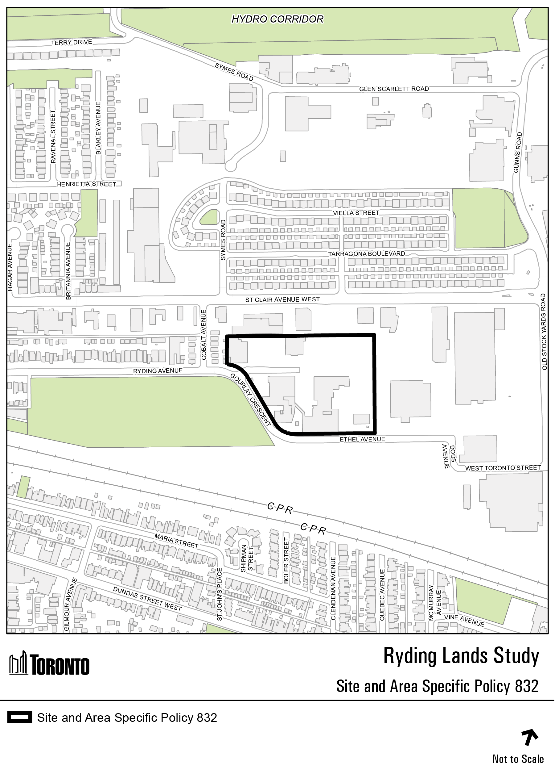
The Ryding Lands were converted from Core Employment Areas to Mixed Use Areas through Official Plan Amendment 653, which was approved by the Minister of Municipal Affairs and Housing on January 27, 2025. This resulted in Site and Area Specific Policy (SASP) 832, which sets out Local Area Study requirements for the Ryding Lands.
Adjacent sites were also converted to Mixed Use Areas through various processes, including:
The outcomes of the Local Area Study will update or replace SASP 832.
The lands subject to SASP 832 are 3.15 hectares (7.78 acres) in size and comprise properties known municipally as 99, 109, 116, 116R and 126-142 Ryding Avenue and 90 Ethel Avenue. These lands will be the focus of the Ryding Lands Study. The study area boundary is yet to be determined.
The transportation network within and around the Ryding Lands Study area can be characterized as primarily auto-oriented with focus on vehicle and truck movement related to the existing employment uses in the area.
The cycling network in the area is fragmented and lack connections, with existing cycling infrastructure along Runnymede Road and a small section of Ryding Avenue with dedicated bikeway infrastructure between the Cobalt Avenue and Gourlay Crescent intersections.
The study area is serviced by local bus transit service along Runnymede Road, St. Clair Avenue West, Keele Street and within the stockyards lands along West Toronto Street and Old Stockyards Road. The area is also served by 512 Streetcar on St. Clair Avenue West. Future connection to the broader city and regional network will be established with the proposed St. Clair-Old Weston Station.
One of the many goals of the Ryding Lands Study is to improve mobility and access within and through the study lands for all modes of transportation, including improving active transportation. This includes identifying improvements to the existing street network for cyclists and pedestrians as well as identifying ways new connections can be made through the area by identifying locations for new streets.
Date: Wednesday April 15, 2026
Location: David Appleton Community Centre (33 Pritchard Avenue, York, ON, M6N 1T4)
Time: 6:30 to 8:30 p.m. (Presentation at 7 p.m.)
Join us for a Study update, and to provide your input and feedback on the emerging directions for the Study.
December 10, 2025
Identify the study scope and understand existing conditions.
Develop and test land use options, and engage community.
Select preferred option, draft policies, and further community engagement.
All proposed time frames are approximate and subject to change.
Jessica Krushnisky, Senior Planner
Strategic Initiatives, Policy & Analysis
City Planning Division
Metro Hall
22nd Floor, 55 John Street
Toronto ON M5V 3C6
Telephone:416-392-7215
Email: Jessica.Krushnisky@toronto.ca
City Planning collects your personal email address under the legal authority of the Planning Act, section 17(15); the City of Toronto Act, 2006, section 8; and Item 2023.PH5.3, City Council Decision 6, 10, 11, 12, 13, as confirmed by the City of Toronto By-law 785-2023 and 822-2023. The information will be used to confirm and administer a subscription to electronic notifications regarding the Ryding Lands Local Area Study, specifically in promoting the project and providing updates about key milestones and public engagement opportunities. Questions about this collection can be directed to the Project Manager, Strategic Initiatives, Policy and Analysis, City Planning, Metro Hall, 22nd Floor, 55 John Street, Toronto, Ontario, M5V 3C6, or by telephone at 416-392-6214.
A Compatibility Study is the first step in deciding how lands in the Sheppard & McCowan Regeneration Areas will be used in the future. This work will inform future study requirements for the area, and may lead to an updated Site and Area Specific Policy 793 or the creation of a new policy framework for the area.
The Sheppard & McCowan Regeneration Areas were converted from General Employment land use designations to Regeneration Areas through Site and Area Specific policy (SASP) 793, through Official Plan Amendment 653, which was approved by the Minister of Municipal Affairs and Housing on January 27, 2025.
The Study Area is located in Scarborough, bounded by Sheppard Avenue East, McCowan Road, East Highland Creek, and the east property line of 4560 Sheppard Avenue East.
Rory McNeil, Senior Planner
Strategic Initiatives, Policy & Analysis
City Planning Division
Metro Hall
22 Floor, 55 John St.
Toronto ON M5V 3C6
Telephone: 416-394-5683
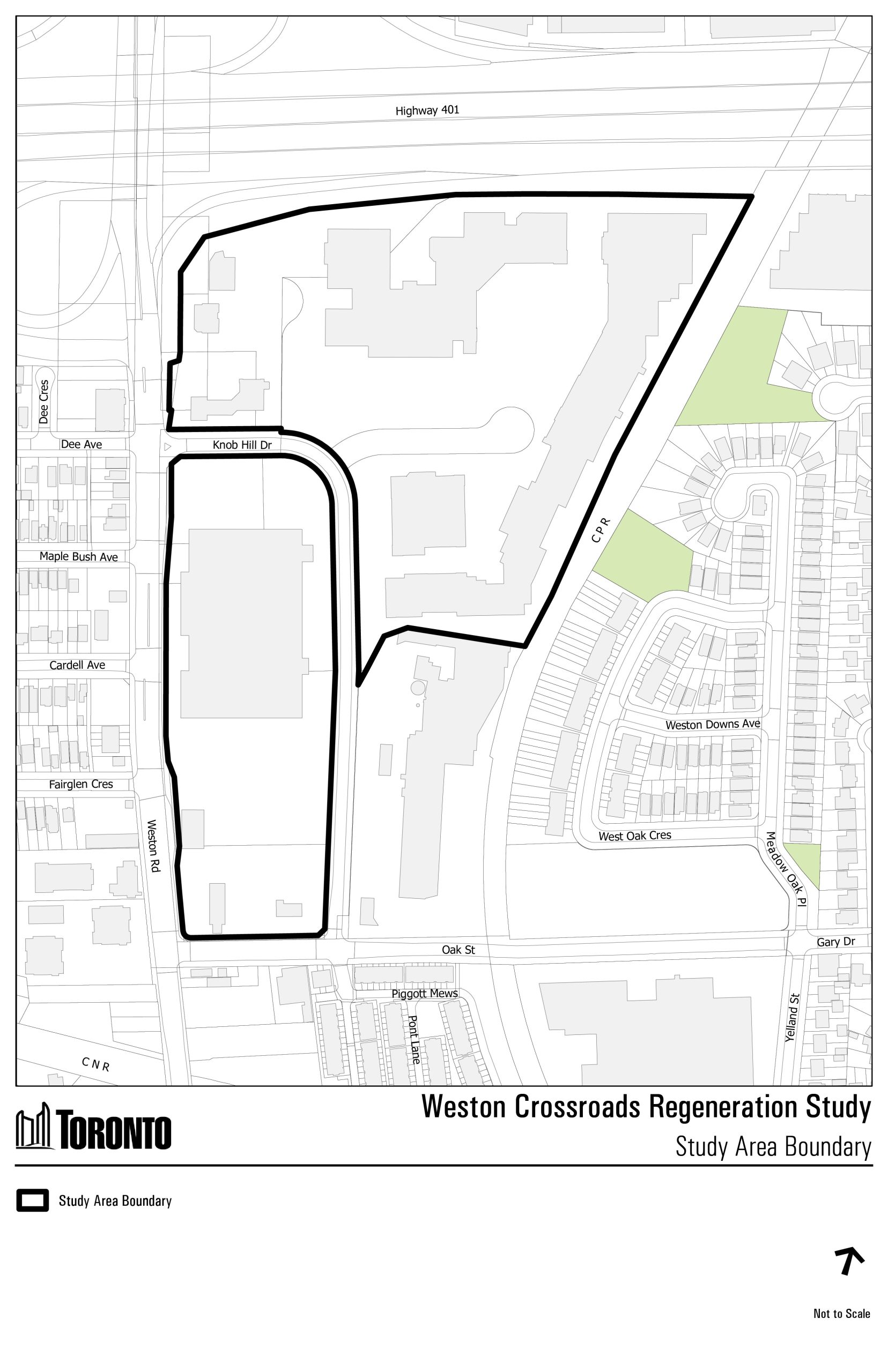
The Regeneration Study for the subject lands – located southeast of the Weston Road and Highway 401 intersection – will help guide the area’s transition from supporting primarily retail and commercial service uses to allow for new uses such as housing, community services, and amenities that are critical to creating a complete community. The Regeneration Study will result in an applicant-initiated amendment to the Official Plan – the City’s overarching policy document guiding growth and development.
Weston Crossroads Regeneration Area Study was converted from the General Employment land use designation to the Regeneration Areas land use designation through Official Plan Amendment 653, which was approved by the Minister of Municipal Affairs and Housing in January 2025. This resulted in a Site and Area Specific Policy (SASP) 833, which sets out the requirements for a Regeneration Area Study for the subject lands. The outcomes of the Weston Crossroads Regeneration Area Study will update or replace SASP 833.
The Weston Crossroads Regeneration study area is approximately 14.8 hectares (36.5 acres) and includes the properties at 2541-2549 and 2625 Weston Road.
Evan Sinclair, Planner
Strategic Initiatives, Policy & Analysis
City Planning Division
Metro Hall
22 Floor, 55 John Street.
Toronto ON M5V 3C6
Telephone: 416-338-6279
Your voice matters. The City of Toronto is committed to meaningful community engagement. Whether you live, work, study, or run a business in the area, your feedback will help shape policies and priorities that reflect local needs and aspirations.
Here’s how you can participate: