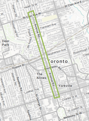
The Avenue Road Study identified opportunities to improve safety, mobility, and streetscape to better serve all road users on the street segment between Bloor Street West and St. Clair Avenue West.
In summer and fall 2024, safety improvements were installed between Bloor Street West and Dupont Street Recommendations on the long-term vision for Avenue Road and near-term plan for the segment between Dupont Street and St. Clair Avenue West are anticipated to be made to the Infrastructure and Environment Committee at a future meeting.
Staff are monitoring travel patterns and traffic behaviours on Avenue Road and surrounding neighbourhood streets. Findings from monitoring are anticipated to be shared in an update report one-year following installation. City Council has requested that staff conduct traffic counts and observations on local streets, identify and recommend actions to mitigate neighbourhood traffic infiltration, where appropriate, and publish data and updates on the project webpage.
The City continues to discuss next steps for the Avenue Road Study with the Province while also continuing to assess the impacts on the City’s transportation infrastructure.
City Council directed staff to undertake the Avenue Road Study to identify opportunities to improve safety, mobility and streetscape to better serve all road users. The current conditions of Avenue Road:
The Study advances the goals of Toronto’s Vision Zero Road Safety Plan, TransformTO, Complete Streets Guidelines, and Road to Health: Healthy Toronto by Design.
The Study is premised on the understanding that full reconstruction of Avenue Road is not scheduled in the City’s Ten-Year Capital Plan for major roadwork. Full road reconstructions typically only take place every 50 years. The study identified feasible actions that could be delivered in advance of full reconstruction, in the near-term (the next 1-5 years). Additionally, the study will identify a vision for the future of the roadway that can guide reconstruction, when it is scheduled. The use of near-term, ‘quick-build’ measures will also allow staff to observe the impact on travel times, motor vehicle speeds and overall safety and make improvements to the design where necessary.
Sidewalk reconstruction is typically bundled with road reconstruction work for efficiency and to reduce impacts to residents. Widening sidewalks on Avenue Road would require moving the curbs and would impact the underground infrastructure and utilities. For this reason, the City would explore sidewalk widening when Avenue Road is scheduled to undergo a full reconstruction. Avenue Road is not scheduled for reconstruction within the next ten years.
The study identified near-term actions that could be implemented in the next 1-5 years to increase space, comfort and protection for pedestrians and encourage compliance with the speed limit. This includes provision of pedestrian space in the existing curb lanes where feasible.
The long-term scenarios for Avenue Road would involve widening sidewalks to meet or exceed the City standard of 2.1 metres.
Avenue Road’s current road design reflects legacy standards, including narrow sidewalks widths, no designated cycling facilities and a wide roadway that encourages speeding.
The current configuration predates the Complete Streets Guidelines which aim to design streets for people, place-making and prosperity and serve many roles, functions, and users. The Avenue Road Study recommends a lane reduction from six to four, and additional turning lanes at intersections, where feasible.
Reallocating road space to other uses would improve safety conditions for all road users, specifically pedestrians and people cycling, and would encourage compliance with the regulatory speed limit. Lane reduction could be completed in advance of road reconstruction.
A feasibility assessment was undertaken to study the operational impacts of reallocating road space to accommodate complete street design elements that improve mobility options and road user safety. Network modeling and intersection testing was conducted in the study area to support the feasibility assessment and identify potential mitigation measures. Traffic studies collected between 2021 and 2023 were used as a baseline for vehicle volume modelling.
Network modeling compared the existing conditions on Avenue Road (six lanes) and Yonge Street (two lanes) and speed limit of 50 km/h against an alternative scenario for reducing the number of motor vehicle lanes on Avenue Road to four, and speed limit of 40 km/h.
Network modelling indicated:
Intersection testing was completed using the Synchro modelling software. This allowed Transportation Services to understand block-by-block operational needs and constraints along the length of Avenue Road and inform designs that aim to reduce traffic infiltration on local streets. Intersection testing indicated an acceptable level of service for motor vehicle traffic.
The Complete Streets Guidelines aim to design streets for people, place-making and prosperity and to serve a multitude of roles, functions and users. Complete streets elements, like those proposed and approved on Avenue Road, improve the experience for vulnerable road users like pedestrians.
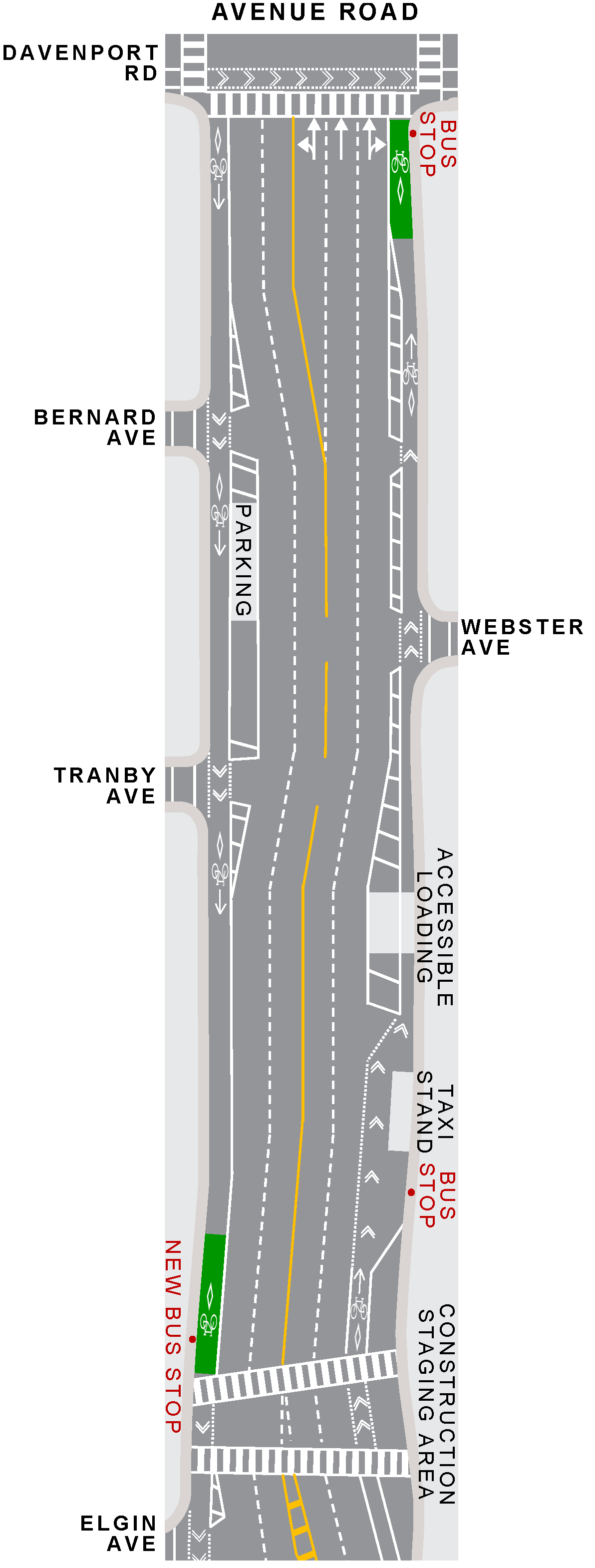
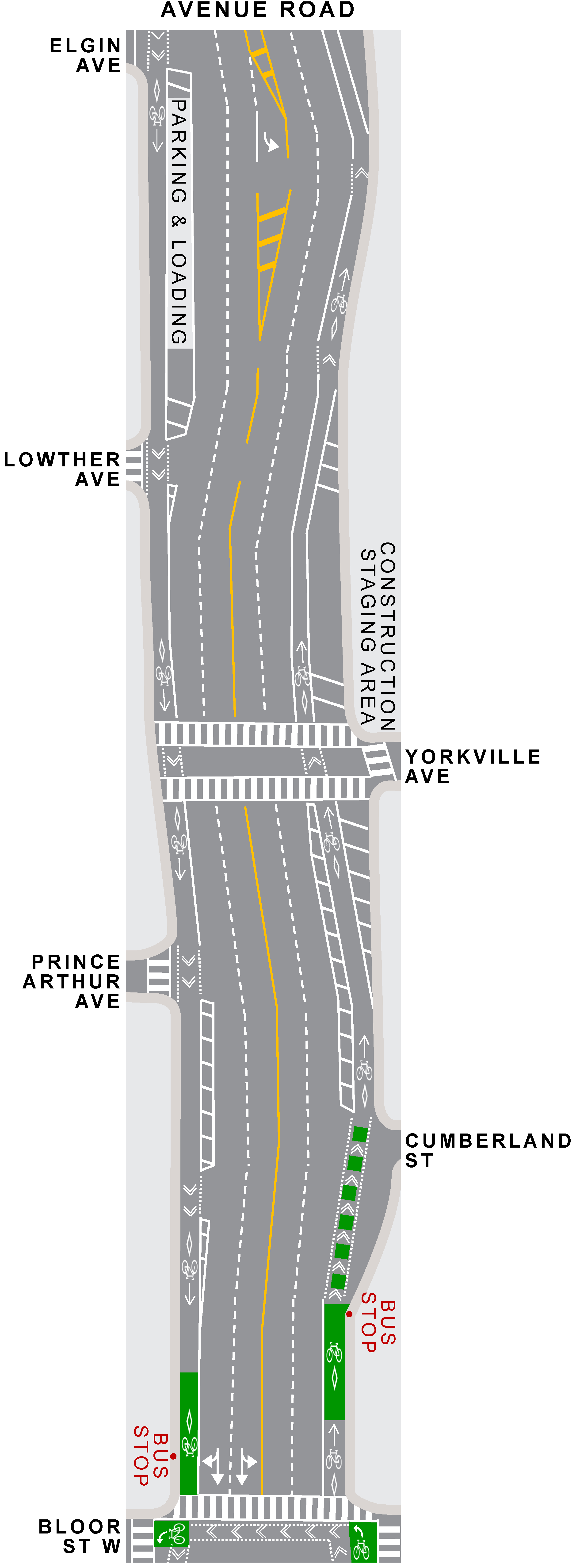
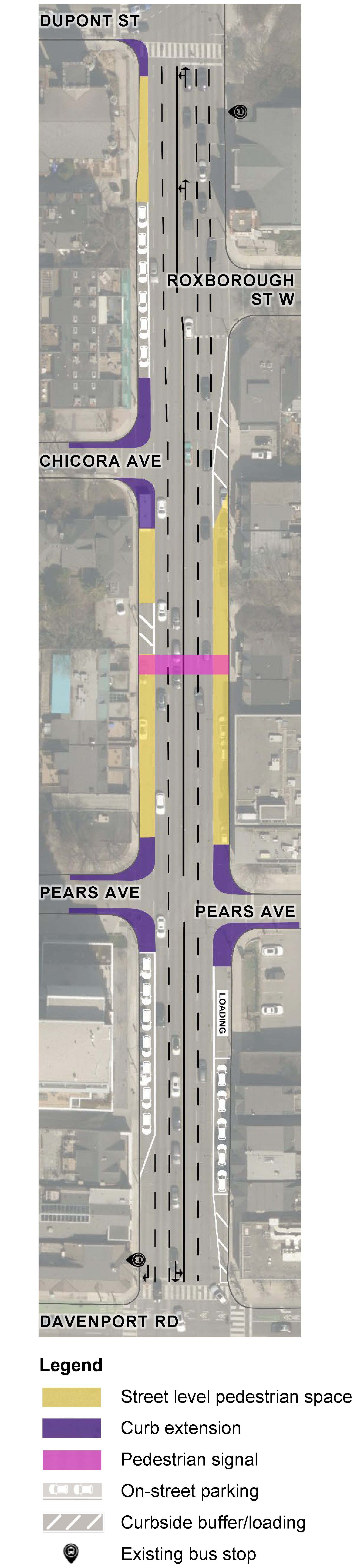
Pedestrian Space: designated pedestrian facilities at road level
Cycle Tracks: bikeways that are separated from vehicle traffic by concrete curbs, planter boxes, bollards, or parked cars
Curb Extensions: localized road narrowings for short sections where pavement width is reduced by extending the curb into the roadway
Loading/Buffer Zones: designated space for loading and unloading activities
Staff are developing a monitoring plan to track travel patterns and traffic behaviours on Avenue Road and surrounding neighbourhood streets. City Council requested staff to conduct traffic counts and observations on local streets, identify and recommend actions to mitigate neighbourhood traffic infiltration, where appropriate, and publish data and updates on the project webpage.
Through the monitoring plan staff will track:
Feedback gathered through the two phases of consultation and meetings with community groups, along with technical considerations and City policies and guidelines, have informed the proposed design. Key design changes based on public and community feedback include:
The study area is Avenue Road from Bloor Street West on the south to St. Clair Avenue West on the north.
A complete street redesign for Avenue Road from Bloor Street West to Davenport Road was implemented based on traffic analysis, corridor conditions, and public feedback to improve comfort and safety for all road users, particularly for pedestrians and people cycling. The protected cycle tracks on Avenue Road provide an alternative north-south cycling connection during expected TTC construction of a new subway station at Bloor/Yonge, and provides connections to existing bikeways on Davenport Road, Bloor Street West and Queen’s Park/University Avenue.
Key changes are summarized below.
Need assistance? While we aim to provide fully accessible content, there is no text alternative available for some of the content on this page. If you require alternate formats or need assistance understanding our maps, drawings, or any other content, please contact us at AvenueRoadStudy@toronto.ca
The Avenue Road Study reviewed traffic data, roadway conditions and public feedback to identify near-term actions that could be implemented quickly to increase space, comfort and protection for pedestrians and reduce speeding. These near-term actions include the provision of street level pedestrian spaces in the existing curb lanes where feasible, and a new pedestrian signal at Ramsden Park (to be installed in 2025).
The street level pedestrian spaces will have accessible ramping and physical barriers to provide separation from motor vehicle lanes. The barriers will be painted by local artists.
Key changes are summarized below.
Need assistance? While we aim to provide fully accessible content, there is no text alternative available for some of the content on this page. If you require alternate formats or need assistance understanding our maps, drawings, or any other content, please contact us at AvenueRoadStudy@toronto.ca
A final Avenue Road Study report will be presented at a future Infrastructure and Environment Committee meeting to provide recommendations on the long-term vision for Avenue Road, including the segment between Dupont Street and St. Clair Avenue West. A range of options are being considered to improve safety, mobility choices and streetscape.
Review background material and section-by-section maps with detailed information about initial proposed actions:
All proposed improvements were assessed through an evaluation process that considered the extent to which each solution addresses safety concerns, advances the City’s goals and policies, impacts the neighbourhood and the road network, as well as availability of resources.
Need assistance? While we aim to provide fully accessible content, there is no text alternative available for some of the content on this page. If you require alternate formats or need assistance understanding our maps, drawings, or any other content, please contact us at AvenueRoadStudy@toronto.ca
Phase Two consultation took place in fall 2023 and invited feedback on the potential near-term actions and long-term vision for Avenue Road.
Phase One consultation took place in spring 2022 to verify concerns and priorities previously raised for Avenue Road from St. Clair Avenue West to Bloor Street West, and to identify concerns and priorities not previously captured.
City Council approved, with amendments, the installation of road safety improvements on Avenue Road between Bloor Street West and Dupont Street. You can review the staff reports and final decisions below:
At City Council, staff were granted delegated authority to make minor adjustments to by-laws for up to 18 months after installation. The streamlined process enables Transportation Services to make minor adjustments to respond to Councillor and public feedback or improve safety conditions without delay.
Councillors and City staff initiated the project in response to concerns from local residents about road user safety, the speed of motor vehicle traffic, lack of space for pedestrians, and lack of bikeways along Avenue Road. In 2019, City Council directed staff to undertake the Avenue Road Study to address safety and mobility concerns. (Item 2019.TE5.81 ).
In 2020, City Council authorized an acceleration of new cycling projects as a pandemic response. Avenue Road between Bloor Street West and Davenport Road was considered and recommended to be implemented after a construction work zone on the east side north of Cumberland Street had been removed. In 2021, City Council included Avenue Road as a corridor under study for bikeways in the 2022-2024 Cycling Network Plan .
Previous Council motions related to this study include:
If you are interested in being notified of project milestones and public consultation opportunities, sign up for the email list by contacting AvenueRoadStudy@toronto.ca.