April 2026: Post-installation Monitoring Report that analyzes changes in speed, volume and travel time on Avenue Road from Bloor Street West to Dupont Street is now available.
The Avenue Road Study identified opportunities to improve safety, mobility, and streetscape to better serve all road users on Avenue Road between Bloor Street West and St. Clair Avenue West. In summer and fall 2024, safety improvements were installed between Bloor Street West and Dupont Street.
Study Area
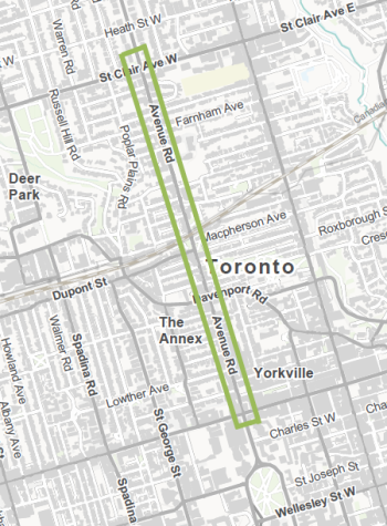
The study area was Avenue Road from Bloor Street West on the south to St. Clair Avenue West on the north.
Background
City Council directed staff to undertake the Avenue Road Study to identify opportunities to improve safety, mobility and streetscape to better serve all road users. Challenges the study sought to address included narrow sidewalks widths, lack of designated cycling facilities and a wide roadway that encouraged speeding.
Full reconstruction of Avenue Road, enabling changes to the road design, is not scheduled in the City’s Ten-Year Capital Plan for major roadwork. Full road reconstructions typically only take place every 50 years. The study identified feasible near-term actions that could be delivered in advance of full reconstruction. Additionally, the study identified a vision for the future of the roadway that can guide reconstruction, when it is scheduled.
In 2024, City Council approved, with amendments, the installation of road safety improvements on Avenue Road between Bloor Street West and Dupont Street. The implemented changes from Bloor Street West to Dupont Street align with the Complete Streets Guidelines which aim to design streets for people, place-making and prosperity and serve many roles, functions, and users.
Review the staff reports and final decisions below:
- Item – 2024.IE14.4 Cycling Network Plan – 2024 Cycling Infrastructure and Missing Sidewalk Installation – Third Quarter Update (Bloor Street West to Davenport Road)
- Item – 2024.TE14.38 – Avenue Road Study – Interim Update and Proposed Site-Specific Road Safety Improvements (Davenport Road to Dupont Street)
Previous Council motions related to this study include:
Post-Installation Monitoring
In July 2024, road safety improvements and bikeways were installed on Avenue Road between Davenport Road and Bloor Street West, and in October 2024, road safety improvements and pedestrian spaces were installed on Avenue Road between Dupont Street and Davenport Road. A new pedestrian signal was installed on Avenue Road, in front of Ramsden Park in fall 2025.
Vehicle speed and volume data was collected at various locations along Avenue Road, between Bloor Street West and Dupont Street, and surrounding neighbourhood streets before and after installation of changes on Avenue Road. Vehicle travel time data is sourced from HERE Technologies, a third party navigation company. The data was reviewed and analyzed to compare the conditions before and after implementation of changes. Key findings are:
- Motor vehicle operating speeds have reduced approximately 10-15 kilometers per hour, representing an improvement to road safety and compliance with the speed limit.
- Data does not show any significant changes to travel times on Avenue Road and nearby corridors since October 2024 when the roadway reconfiguration was installed. The travel times in southbound direction during the PM peak, and in both directions in the AM peak are consistent with pre-installation travel times. The northbound PM peak is approximately one minute longer than pre-installation.
- Local streets accessible from Avenue Road between Dupont Street and Bloor Street West typically run perpendicular to Avenue Road and do not form an alternative route that could be used to bypass Avenue Road. There is limited potential for changes to Avenue Road to impact travel patterns on local streets.
Review the full post-installation Monitoring Report.
Design Details: Avenue Road from Bloor Street West to Davenport Road
The complete street redesign installed on Avenue Road provides an alternative north-south cycling connection during expected TTC construction of a new subway station at Bloor/Yonge, and provides connections to existing bikeways on Davenport Road, Bloor Street West and Queen’s Park/University Avenue.
Key design details are summarized below.
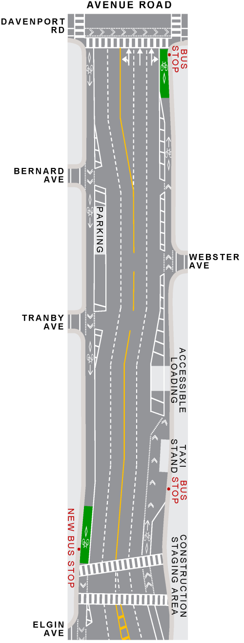

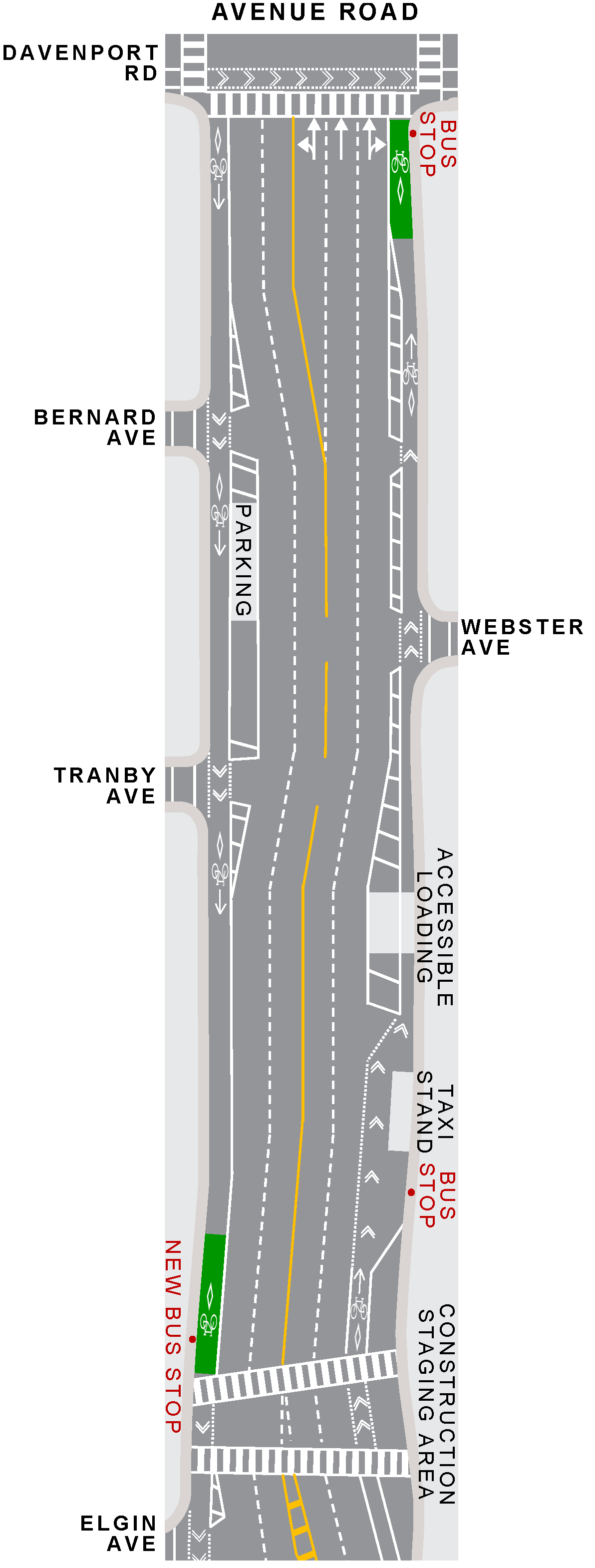
Avenue Road – Davenport Road to Bernard Avenue
- On-street cycle tracks on both sides of the street
- Two motor vehicle lanes maintained in each direction (reduction from six lanes to four total lanes) with a shared northbound left-turn and through lane at the intersection of Avenue Road and Davenport Road
- Removal of four on-street parking spaces on the west side of the street and five on-street parking spaces on the east side
Avenue Road – Bernard Avenue to Cumberland Street
- On-street cycle tracks on both sides of the street, with unprotected bike lanes around the approved construction staging areas at 89 Avenue Road and 33-49 Avenue Road/136-148 Yorkville Avenue
- Two motor vehicle lanes maintained in each direction (reduction from six lanes to four total lanes)
- No change to the centre turn lane at 87 Avenue Road to accommodate southbound left-turns into the Whole Foods Market underground parking garage
- Addition of one on-street parking space to existing seven spaces on the west side of the street between Bernard Avenue and Tranby Avenue
- Removal of four on-street parking spaces and one loading zone on the west side of the street between Tranby Avenue and Elgin Avenue and six on-street parking spaces on the east side of the street between Webster Avenue and Elgin Avenue
- Existing accessible loading zone at 111 Avenue Road shifted away from the sidewalk, with the cycle track located adjacent to the curb and an accessible platform added across the cycle track
- No change to existing nine on-street parking spaces and loading zone on the west side of the street between Elgin Avenue and Lowther Avenue
- New southbound TTC bus stop at 88 Avenue Road (near traffic signal adjacent to Whole Foods Market) and removal of bus stops at 96 and 38 Avenue Road
- Removal of northbound TTC bus stop at 55 Avenue Road
- To be implemented following the clearance of lane occupancies from construction staging areas:
- Protected cycle tracks to be installed at 89 Avenue Road and 33-49 Avenue Road
- Existing taxi stand at 103 Avenue Road to be shifted away from the sidewalk, with the cycle track relocated adjacent to the curb
- New northbound TTC bus stop at 87 Avenue Road (near traffic signal adjacent to Whole Foods Market) and removal of bus stop at 101 Avenue Road
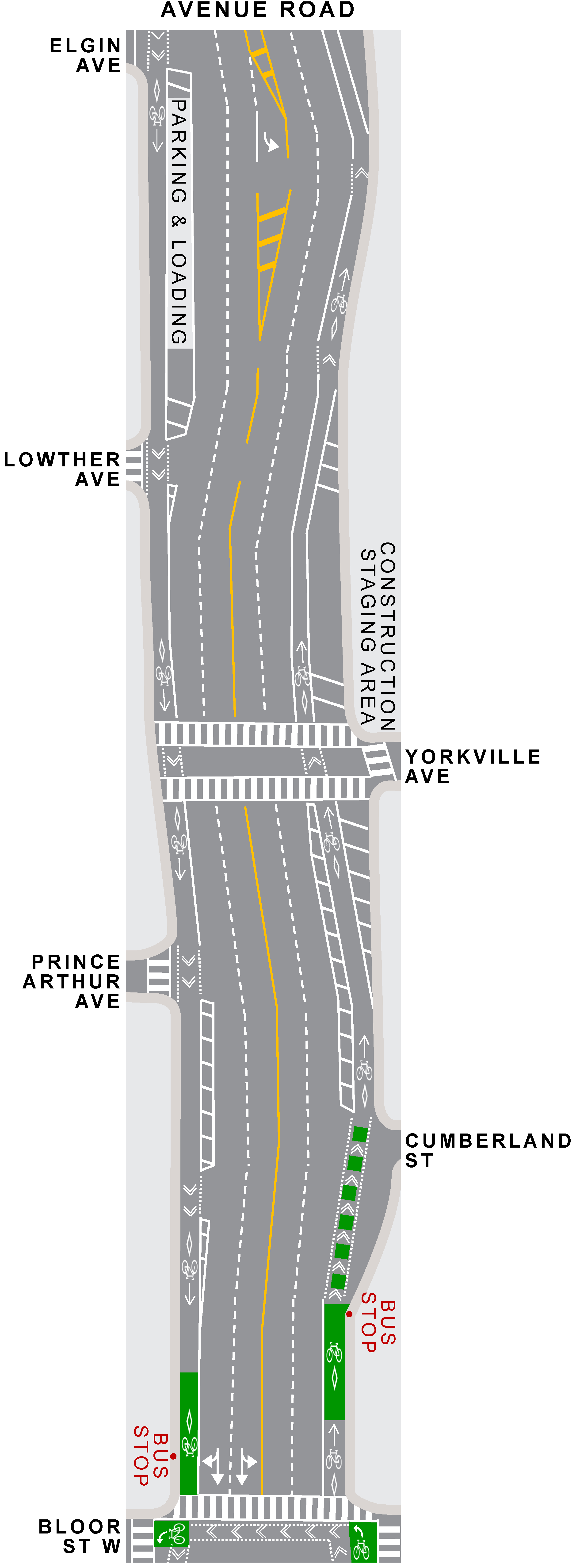
Avenue Road – Cumberland Street to Bloor Street West
- On-street cycle tracks on both sides of the street
- Two motor vehicle lanes maintained in each direction (reduction from five lanes to four total lanes) with the removal of the designated southbound right-turn lane at Bloor Street West
Need assistance? While we aim to provide fully accessible content, there is no text alternative available for some of the content on this page. If you require alternate formats or need assistance understanding our maps, drawings, or any other content, please contact us at AvenueRoadStudy@toronto.ca
Design Details: Avenue Road from Davenport Road to Dupont Street
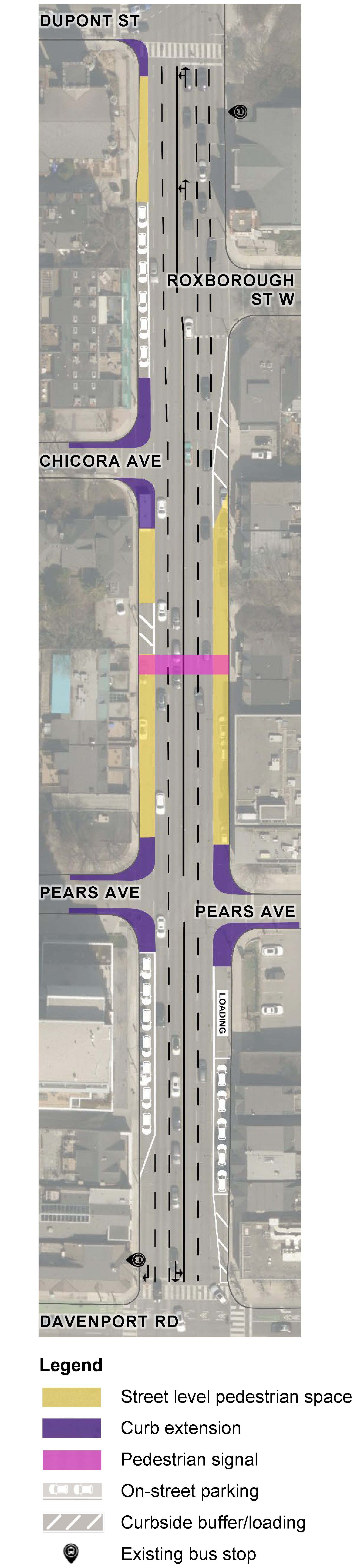
The Avenue Road Study implemented pedestrian spaces and physical barriers between Davenport Road and Dupont Street to increase space, comfort and protection for pedestrians and reduce speeding, and installed a new pedestrian signal at Ramsden Park.
Key changes are summarized below.

Avenue Road – Dupont Street to Chicora Avenue
- Two motor vehicle lanes maintained in each direction (reduction from six lanes to four lanes) with an additional shared northbound left-turn and through lane at the intersection of Avenue Road and Dupont Street
- Street level pedestrian space on the west side of the street in front of the Church of the Messiah and Avenue Road Food Bank with accessible ramping and physical barrier separation from motor vehicle lanes
- Removal of two Pay and Display on-street parking spaces from the west side of Avenue Road between the Church of the Messiah and Chicora Avenue (reduction from eight spaces to six spaces) and conversion to all-day parking
- Painted curb extensions and flexible bollards at Dupont Street and Chicora Avenue intersections
Avenue Road – Chicora Avenue to Pears Avenue
- Two motor vehicle lanes maintained in each direction (reduction from six lanes to four lanes)
- New pedestrian signal at Ramsden Park (installed in 2025)
- Street level pedestrian space on both sides of the street with accessible ramping and physical barrier separation from motor vehicle lanes
- Removal of seven Pay and Display on-street parking spaces on the west side of the street and twelve Pay and Display on-street parking spaces on the east side of the street in order to meet clearance requirements on either side of the new pedestrian signal
- Painted curb extensions and flexible bollards at Pears Avenue intersection
Avenue Road – Pears Avenue to Davenport Road
- Two motor vehicle lanes maintained in each direction (reduction from six lanes to four lanes) with an additional dedicated southbound right-turn lane at Davenport Road
- Addition of four full-time Pay and Display on-street parking spaces on the west side of the street near Pears Avenue (increased from three spaces to seven spaces) and conversion to all-day parking
- Formalized loading zone at 189 Avenue Road
- Addition of one full-time Pay and Display on-street parking space to the east side of the street (increased from four spaces to five spaces) and conversion to all-day parking
Need assistance? While we aim to provide fully accessible content, there is no text alternative available for some of the content on this page. If you require alternate formats or need assistance understanding our maps, drawings, or any other content, please contact us at AvenueRoadStudy@toronto.ca
Public Consultation
Phase Two consultation took place in fall 2023 and invited feedback on the potential near-term actions and long-term vision for Avenue Road.
Phase One consultation took place in spring 2022 to verify concerns and priorities previously raised for Avenue Road from St. Clair Avenue West to Bloor Street West, and to identify concerns and priorities not previously captured.
Date modified: April 24, 2026