During heavy rain, the sewers can become overloaded. This increases pressure on the sewer systems and overland drainage routes, such as roads, local rivers and streams, which can increase the risk of basement flooding.
The City’s Basement Flooding Protection Program is a multi-year program helping to reduce the risk of flooding by making improvements to the sewer system and overland drainage routes. Projects are taking place in basement flooding study areas across the city.
From 2006 to 2024, the City conducted Environmental Assessment studies in 67 different areas in Toronto to determine the cause of basement and road surface flooding. The studies also looked at improvements to the sewer and drainage systems to be made within the City’s right-of-way or on City property, such as parks and ravines.
The typical Environmental Assessment study process included:
collecting data and conducting a technical assessment which included reviewing flooding history; analyzing sewer data records; survey catch basins, roof downspout connections and low-lying areas; and monitoring water flow
identifying problems and opportunities, determining where repeated flooding occurs and analyzing the causes of flooding
evaluating alternative infrastructure solutions, including but not limited to drainage measures, sewer upgrades, stormwater control and underground storage
providing opportunities for public input through an online survey, public drop-in events and stakeholder meetings
selecting preferred solutions, producing conceptual designs and reports that were available for public review for a 30-day period
Improvements Within the City's Right-of-Way & City Property
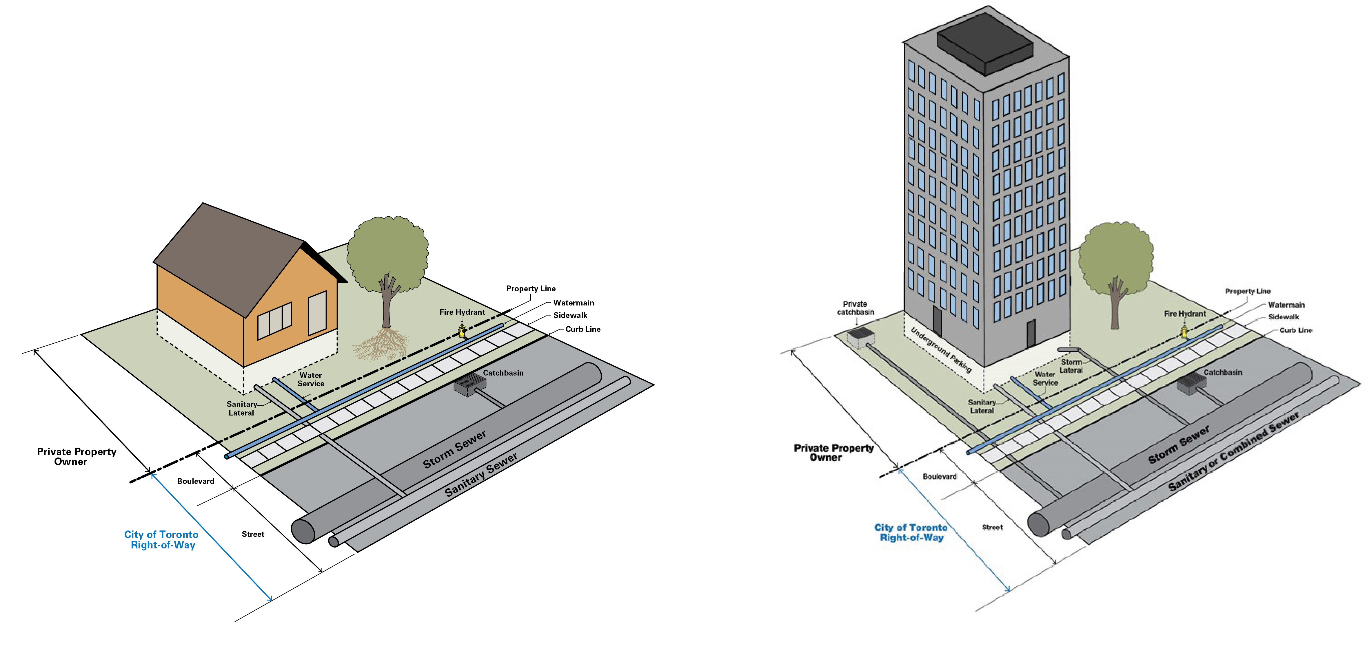
The City’s right-of-way extends from the property line to the street. The program’s Environmental Assessment studies considered improvements to the sewer and drainage system within the City’s right-of-way and on City property, such as parks and ravines.
These studies did not assess drainage issues on private property. Managing drainage on private property is the responsibility of the property owner.
Private property owner responsibilities vs. City of Toronto responsibilities.
Improvements under the Basement Flooding Protection Program may include:
adding new storm and sanitary sewers
upsizing existing storm sewers
installing inlet control devices (to slow the flow of rain into the sewer system)
putting catch basins (square grates on the side of the road) in low-lying areas
sealing sanitary maintenance hole covers
constructing underground storage facilities
Basement Flooding Protection Program improvements do not guarantee flood prevention; however, they are intended to improve the level of service and reduce flood risk where implemented.
What the City is responsible for
What private property owners are responsible for
Managing stormwater within the City’s right-of-way and City properties:
Streets are designed to carry stormwater flows that exceed storm sewer capacity; temporary ponding is expected during major rainstorms.
Sewer upgrades on your street, including increasing the size of sewer pipes as identified through Basement Flooding Protection Program studies
Investigating basement flooding incidents reported to 311
Operation and maintenance of the existing sewer system
Operation and maintenance of the drainage system on your property to protect against flooding caused by issues including:
improper lot grading
driveway and backyard drainage and private property catch basins
clogged foundation drains in basement or underground parking garage
backwater valve and sump pump failures
clogged drains due to private tree roots or items poured down the drain (such as fat, oil and grease)
cracks or leaks in your home foundation, basement walls, windows and/or doors
Reporting flooding incidents, overflowing catch basins and sewer blockages to 311 is recommended
About Construction
All Environmental Assessment studies were completed as of 2024. Basement flooding projects that have been selected for implementation are sequenced into a five-year project list. This list is presented to City Council every year as part of the budget process.
Projects are prioritized and scheduled to protect the greatest number of properties as soon as possible, within approved budgets and coordinated with other construction work – as per Council approved criteria. Projects are prioritized for implementation based on a Council-adopted $68,000 cost-per-benefitting-property threshold.
Projects with a cost less than $68,000 per benefitting property at the study stage and preliminary design stage can be selected to proceed to detailed design and construction.
Projects that exceed the $68,000 cost-per-benefitting-property threshold are added to the deferred projects list.
Once all qualifying projects under $68,000 per benefitting property have been scheduled for implementation, remaining projects are sequenced in order of achieving the greatest to least impact. The greatest impact will be determined based on the following criteria:
Hazard: Projects that mitigate a greater extent of flooding and/or a higher probability of flooding
Exposure: Projects that are more likely to benefit residential basements and/or other critical infrastructure
Vulnerability: Projects in areas with a higher Ontario Marginalization Index
Cost: Projects with a lower capital cost-per-benefitting-property
In 2026, the City is conducting a program-wide study to review and improve how projects are prioritized and sequenced, including summarizing the cost and schedule to design and construct identified solutions.
Stages of construction
The length and type of construction will vary depending on the type of projects being implemented.
There are several stages of work that must happen before a construction project is completed:
Preliminary design: Preliminary engineering drawings are developed and shared with City departments, utilities and regulatory authorities for feedback. Their input is incorporated into the design.
Detailed design: Final detailed engineering drawings are developed, required approvals/clearances are secured, and permits required to undertake the work are obtained (including permits secured by the contractor, as applicable).
Construction: About two months before construction begins, pre-construction notices are delivered door-to-door to let the community know that a construction project will soon be taking place. About two weeks in advance of work commencing, construction notices are delivered door-to-door and road signage is placed in the community to provide residents with project details. Construction activities related to infrastructure improvements may include excavation of the roadway, sidewalks and/or boulevards.
Restoration: Restoration within construction areas varies by project, and typically involves restoration of road surfaces, sidewalks, curbs, grass and tree plantings.
Working with Local Communities
The City and its contractors are committed to communicating with local communities about basement flooding construction activities and anticipated disruptions in their neighbourhood.
Each construction contract under the Basement Flooding Protection Program has a Field Ambassador who is dedicated to communicating with the local community and the on-site contractor, and responding to construction inquiries during the course of the project.
Field Ambassador contact information is provided in the construction notice for each project. Online versions of the construction notices are available on the City’s Ward Profiles.