Etobicoke York Community Council has adopted the recommended road safety and traffic management changes for the Elms-Old Rexdale neighbourhood. A copy of the staff report is available at EY23.18.
In consultation with the local community, the City is developing a Neighbourhood Streets Plan for the Elms-Old Rexdale area that will address threemain areas of concern:
Road safety for vulnerable road users (i.e., seniors, school children, pedestrians and people cycling)
Excessive speeding
Excessive motor vehicle traffic on local streets
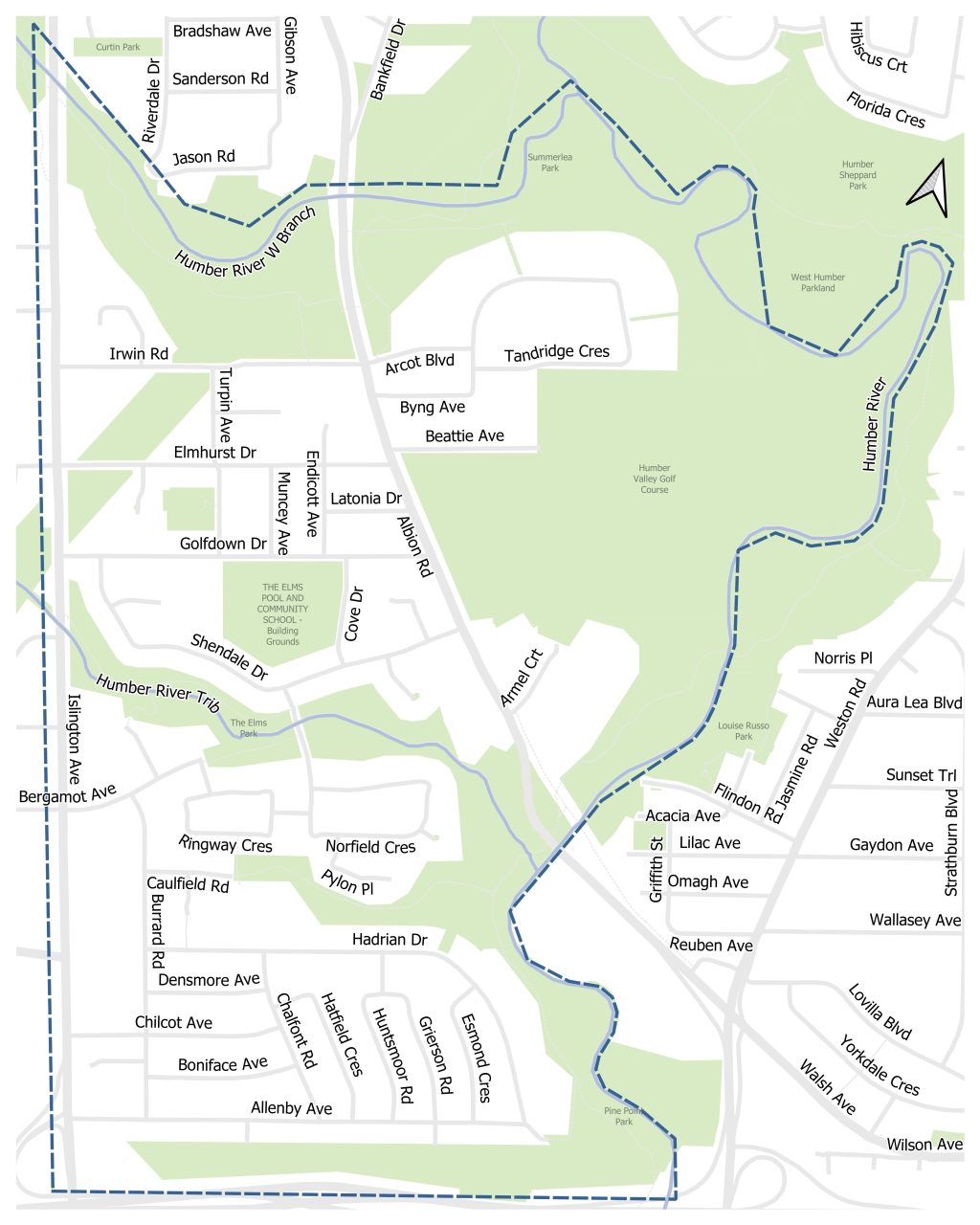
Project Area
The project area islocatedbetweenIslington Avenue to the west, Highway 401 to the south, and the Humber River to the north and east.
Background
The Elms-old Rexdale neighbourhood was nominated for a Neighbourhood Streets Plan (NSP) by the local City Councillor in 2023. Details of the nomination process can be found on the program for Neighbourhood Streets Plan web page.
What is a Neighbourhood Streets Plan?
Neighbourhood Streets Plans (NSPs) are a new service for neighbourhoods where traffic and travel patterns challenge the safety and mobility of people using the streets. Through the NSP process, a team of City staff will work with communities to identify local issues and opportunities, prioritize the greatest needs, and recommend changes to traffic operations and street designs.
NSPs consider the needs of all road users and emphasize the safety of vulnerable road users such as seniors, school children, and pedestrians, and people cycling.
Process
There are several steps to develop a Neighbourhood Streets Plan (NSP). Through the planning process, a team of City staff work with communities to identify local issues and opportunities, prioritize the greatest needs, and recommend changes to traffic operations and street design.
NSPs follow several steps outlined below, and public consultation takes place in two stages.
Step 1: Public consultation on local issues and ideas
Step 2: Develop actions and changes to address issues
Step 3: Public consultation on proposed actions and changes
Step 4: Finalize plan for approval by Community Council
Step 5: Implement short-term actions
Step 6: Monitor, evaluate, and update community on future changes
NSPs will result in short-term actions (one to two years) which can be made using temporary, flexible materials like signs, paint, and bollards, and will identify longer-term changes which can be accomplished alongside future programmed road work.
The outcomes of each NSP will be different based on local conditions and the needs of each neighbourhood. Generally, NSPs will recommend actions related to motor vehicle speed and volume management, and traffic safety conflicts on local streets. NSP recommendations are informed by the City’s Traffic Calming Guide, Vision Zero Action Plan, and Complete Streets Guidelines.
Public Consultation
The City of Toronto invited local residents, businesses and organizations to learn more and provide feedback on the Elms-Old Rexdale Neighbourhood Streets Plan project. Public and interest group opinions, along with technical and policy considerations will be used to inform City staff recommendations and decisions to be made by City Council.
Consultation took place over two stages between Spring 2024 and Winter 2025:
Phase 1 presented background information and consulted the community on issues commonly experienced in the neighbourhood and ideas for actions and changes.
Phase 2 consulted the community on proposed short-term actions (1 to 2 years) which can be made using temporary, flexible materials like signs, paint, and bollards, and identified longer-term changes which can be accomplished alongside future programmed road work.
The comment period for Phases 1 and 2 of this consultation has closed.
Information, reference materials, and reports on public consultation activities will be posted here.
Public Consultation – Phase 2
Public Drop-In Event
A Public Drop-In Event was held on January 30, 2025 from 6 p.m. to 8 p.m. at St. Stephen Catholic School, 55 Golfdown Drive. The event provided an opportunity to view the project information panels and speak with members of the project team one-on-one. A Punjabi interpreter was present at the event.
Phase 1 public consultation took place in April 2024. The public consultation report (linked below) provides a detailed summary of all activities that took place and feedback received.
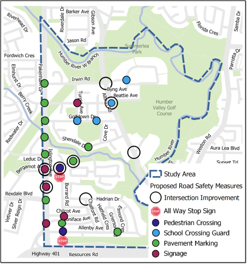
Potential conflicts between road users can be addressed through proposed road safety measures, including:
Intersection Improvements
Curb Extensions (bump-outs) to improve visibility of pedestrians and reduce crossing distances
Left-Turn Calming at key intersections
Head start signals for pedestrians at signalized intersections
Two new All-Way Stop Signs
Two new Pedestrian Crossings
School Crossing Guard studies at intersections with high volumes of school children
Pavement Marking
Re-painted Pavement Markings to improve visibility
High Visibility Crosswalks (zebra markings)
Additional Signage to clarify road rules and increase driver alertness
Proposed Road Safety Measures
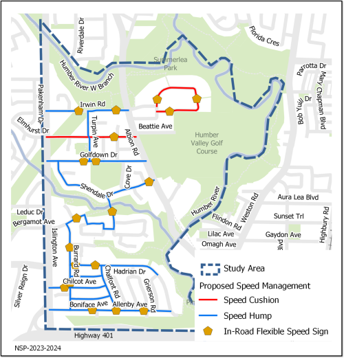
Proposed Changes: Speed Management
Speeds on neighbourhood streets can be reduced through operational and physical changes. Proposed speed management measures include:
Speed Humps on local roads where the operating speed was found to be 8 km/hour or more above the posted speed limit. Speed humps are a simple and effective measure of reducing speeds on local roads. Speed humps are designed to be comfortable to travel over at 30 km/hour.
Speed Cushions include wheel cut-outs for larger vehicles such as buses and emergency vehicles. Speed cushions are intended to reduce impacts on transit and emergency vehicles.
In-Road Flexible Speed Signs to visually narrow the road, increase driver alertness and emphasize the posted speed limit. These signs may result in parking restrictions next to their location, where on-street parking is currently permitted.
Proposed Speed Management Measures
Proposed Changes: Volume Management
The number of motor vehicles that use a road can be managed using operational features or changes to the built environment.
The following volume management measures are proposed:
Proposed traffic calming measures such as speed humps on neighbourhood streets can also make those streets less attractive for non-local travellers. This may result in a reduction of non-local traffic on roads with excessive traffic complaints.
The proposed all-way stop signs at Bergamot Avenue and Burrard Road, and Allenby Avenue and Burrard Road intersections will improve volume management.
Signal timing coordination between traffic signals on Islington Avenue, from Allenby Avenue to Bergamot Avenue, was updated by the end of 2024 to enhance traffic flow on Islington Avenue.
The following studies are planned for 2025 at the intersection of Islington Avenue and Bergamot Avenue:
Study to add a protected northbound left-turn phase
Study to extend the protected southbound left-turn phase to all hours of the day
Study to upgrade traffic signal control technology and add vehicle detection to improve traffic operation
Proposed Transportation Options - Sidewalks
Missing Sidewalk Program
The City of Toronto Missing Sidewalk Program delivers sidewalks where they are not currently present. In Elms-Old Rexdale, sidewalks are generally provided throughout the neighbourhood, however some key connections are missing.
New sidewalks are planned for Conan Road and Grierson Road, which would provide access to Pine Point Park where no sidewalks currently exist.
Adding the missing sidewalk on Hadrian Drive between Esmond Crescent and Allenby Avenue is also proposedalongside future road work on Hadrian Drive
Pedestrian Crossings
Crosswalk pavement markings are proposed at key intersections shown on the Road Safety Measures map.
Two new north-south pedestrian crossings are also proposed at the intersections of Bergamot Avenue and Burrard Road, and Allenby Avenue and Burrard Road.
Proposed New Side Walk
Subscribe for Updates
To receive project updates by email, please contact EORstreets@toronto.ca to be added to the list.