
In consultation with the local community, the City is developing a Neighbourhood Streets Plan (NSP) for the Scarborough Village area that will investigate four main areas of concern:
The City invites residents to learn more about the project and participate in identifying issues, opportunities, and ideas for the study area.
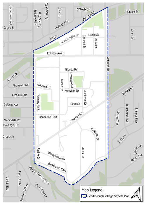
The Scarborough Village Streets Plan focuses on the neighbourhood between Bellamy Road South (west), Markham Road (east), the CN Railway (north), and an area just south of Kingston Road, including Bellehaven Crescent and Hill Crescent south).
The study area covers the western portion of the City of Toronto neighbourhood of Scarborough Village.
The Scarborough Village area was nominated for a neighbourhood Streets Plan by members of the local community. Each year, the City receives a far greater number of requests for neighbourhood scale traffic management, road safety, and active transportation plans than can be fulfilled. The NSP program has established an annual selection process to allocate the available resources for this service in a fair and transparent manner that considers equity, impact, alignment with planned roadwork, and community support. More information on the nomination and selection process can be found on the NSP web page.
Issues raised by residents include excessive speeding, aggressive driving, excessive volume, the need for improvements to walking and cycling routes, frequent vehicle collisions or near-misses and school areas with traffic volume and road safety issues.
Neighbourhood Streets Plans (NSPs) are a new service for neighbourhoods where traffic and travel patterns challenge the safety and mobility of people using the streets. Through the NSP process, a team of City staff will work with communities to identify local issues and opportunities, prioritize the greatest needs, and recommend changes to traffic operations and street designs.
NSPs consider the needs of all road users and emphasize the safety of vulnerable road users such as seniors, school children, and people walking and cycling.
NSPs follow several steps outlined below, and public consultation takes place in two stages.
NSPs will result in a range of proposals, from quick wins to long-term changes:
The outcomes of each NSP will be different based on local conditions and the needs of each neighbourhood. Generally, NSPs will recommend actions related to motor vehicle speed, motor vehicle volume, and traffic safety conflicts on local streets. NSP recommendations are informed by the City’s Traffic Calming Guide, Vision Zero Action Plan, Complete Streets Guidelines, TransformTO Climate Change Action Plan and Toronto Seniors Strategy.
The City of Toronto is inviting local residents, businesses and organizations to learn more and provide feedback on the Scarborough Village Streets Plan. Public and community interest groups’ opinions, along with technical and policy considerations, will be used to inform City staff recommendations and decisions to be made by City Council.
Consultation will take place over two phases between Spring 2025 and Winter 2026.
A Public Drop-In Event was held on December 4, 2025 that included a presentation and Question & Answer period and the opportnity to speak with project staff and view display boards. View the display boards below.
A public drop-in event was held in April 2025.
Residents have raised concerns about pedestrian and cycling safety, unsafe turning movements at intersections, and non-compliance with traffic rules that increase the risk of conflicts between different road users.
To address these issues, the plan proposes a series of changes designed to reduce conflicts and create a safer, more comfortable environment for all users. The proposed changes include:
Residents have raised concerns about speeding throughout the neighbourhood on local and collector roads. In response, the City has already implemented several measures, including lowering speed limits to 30 km/h on local roads and 40 km/h on collector roads, updating gateway signage to reflect these changes and installing driver feedback signs.
Building on these efforts, the plan proposes additional improvements aimed at reducing vehicle speeds, calming traffic, and creating safer, more comfortable streets for all users. The proposed changes include:
(primarily addressed through the safety improvements proposed under Conflict Management)
Residents have raised concerns about high traffic volumes within the neighbourhood. The study identified two main sources of these concerns: school-related congestion during drop-off and pick-up times, and non-local drivers using neighbourhood streets to bypass busier corridors such as Kingston Road and Eglinton Avenue East.
Based on site observations, public feedback, and a review of recent traffic data, the study found that all neighbourhood streets, including those near schools, operate below the City’s standard traffic volume thresholds:
These findings indicate that overall traffic levels are within expected and acceptable ranges, and no additional traffic volume management measures are needed at this time.
While no specific traffic volume control treatments are proposed, proposed speed humps, parking adjustments near schools, and other traffic calming initiatives will help manage driver behaviour, discourage shortcutting by non-local traffic, and improve overall safety and comfort for all road users.
Residents have expressed interest in expanding mobility options through better sidewalks, new cycling connections, and additional Bike Share stations. The City already has several projects underway to fill gaps in the neighbourhood’s cycling network, including the Safer Kingston Road Project, the upcoming Eglinton Avenue East Cycling and Safety Improvements, and the planned Eglinton East Light Rail Transit (EELRT) project.
Building on these initiatives, this plan proposes additional improvements to further enhance local mobility and provide safer, more convenient options beyond driving. Proposed changes include:
Sign up to receive project updates by email.