The Queensway Complete Street project was approved by City Council on April 7, 2022. The Queensway between Mimico Creek and the Humber River will be reconstructed and the watermain will be replaced. The road and watermain works provide an opportunity to review the street for changes to improve safety and operations for people driving, taking transit, walking and cycling. Currently, the project is in detailed design under coordination with other adjacent critical infrastructure works. Due to prioritization of critical repairs to bridges and consideration of traffic impacts, the construction start for the Queensway Complete Street elements is anticipated for 2027. Updates to the timeline will be posted on this webpage when available.
City Council has authorized the installation of The Queensway Complete Street project.
City Council has also requested Transportation Services to, as part of the next Near-Term Cycling Network Plan Update, review opportunities to extend The Queensway Complete Street project to Royal York Road.
You can watch the video of City Council meeting from the Toronto City Council and Committees web page or the City of Toronto’s YouTube channel.
On March 29, 2022, Infrastructure and Environment Committee (IEC) endorsed IE 28.7 – staff recommendations to authorize the installation of The Queensway Complete Street project.
A Virtual Public Meeting was held on Tuesday, December 7, 2021 from 6 to 8 p.m.
The proposed changes on The Queensway are guided by the City’s Vision Zero Road Safety Plan. The plan is focused on eliminating traffic-related fatalities and serious injuries by making our roads safer for everyone, especially vulnerable road users such as seniors, school children, and people walking and cycling. From 2015 to 2019, 338 vehicle collisions occurred on The Queensway, and two collisions resulted in serious injury.
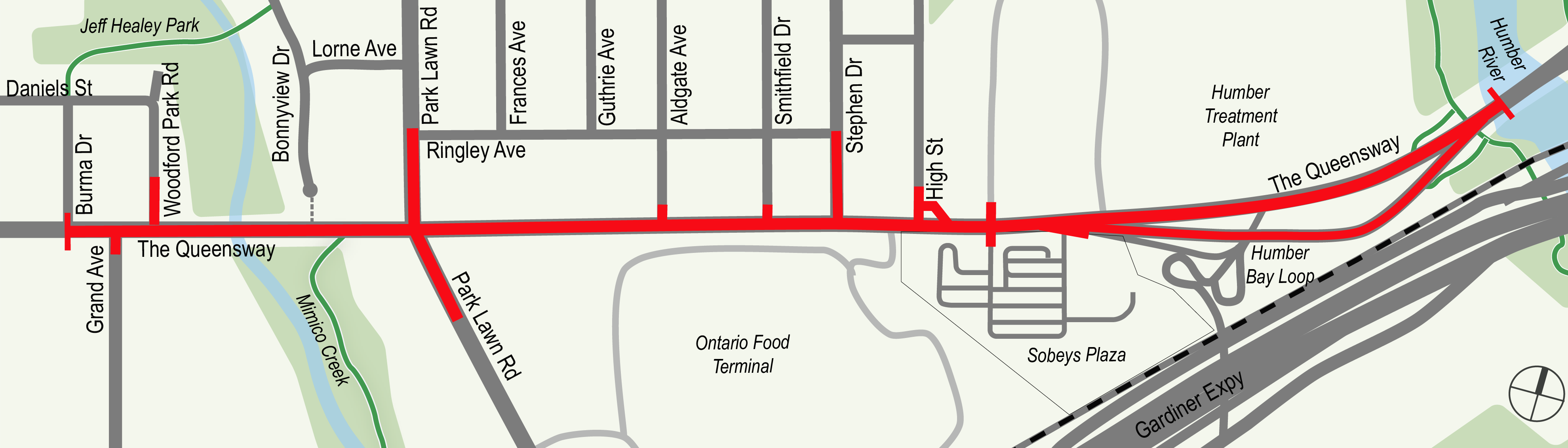
The project area spans along The Queensway from the Humber River to Burma Drive near Mimico Creek.
While we aim to provide fully accessible content, there is no translation or text alternative available for some of the content on this page. If you require translation, alternate formats or need assistance understanding our maps, drawings or any other content, please contact us at cycling@toronto.ca
The proposed design includes shared right-turn and through lanes in both directions on The Queensway at the Park Lawn Road intersection. Drivers in the right lane going eastbound or westbound would be able to travel straight through the intersection or turn right onto Park Lawn Road. The rendering shown in the presentation at the virtual public meeting on December 7, 2021, incorrectly depicted the turn lanes as dedicated right-turn lanes. The rendering will be updated to accurately reflect the design.
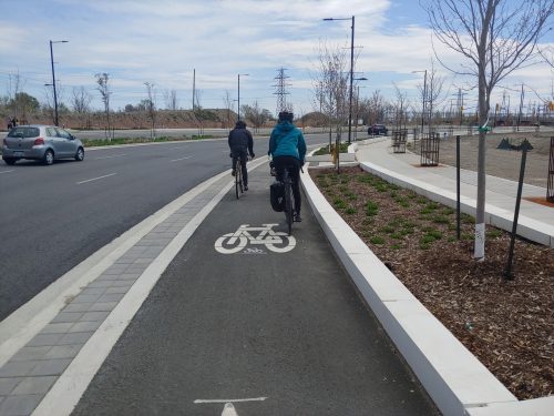
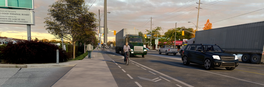
The City is proposing to install raised, protected cycle tracks to provide a safe route for cyclists on The Queensway from Humber River to Burma Drive, with the exception of the Mimico Creek Bridge. The cycle tracks would be raised to be level with the sidewalk, separated from the roadway by a curb, and where possible, additional buffer space to provide protection from motor vehicles. There would also be a buffer space to separate the sidewalk and the cycle tracks. On the Mimico Creek Bridge, a low concrete wall barrier and buffer space are proposed to separate the cycle tracks from vehicle lanes.
Current sidewalks are 1.4 to 1.7 metres wide, and the passable space is only 1.0 m wide at some constrained locations. The City is proposing to widen sidewalks to 2.1 metres where possible to meet the City’s standard outlined in Toronto Accessibility Design Guidelines. The widened sidewalks allow for simultaneous passage of two persons using mobility devices (e.g. a wheelchair).
A centre median is proposed on The Queensway, between Stephen Drive and Park Lawn Road, with a break at Aldgate Avenue. From 2015 to 2019, 338 vehicle collisions occurred on The Queensway and two collisions resulted in serious injury. This new centre median is proposed as a safety measure to reduce the likelihood of left-turn collisions and prevent possible injuries.
The new centre median would prevent vehicles travelling eastbound on The Queensway from making left turns onto properties on the north side of the street. It would also prevent vehicles exiting the properties on the north side from making left turns to travel eastbound on The Queensway.
To access properties on the north side, if travelling eastbound on The Queensway:
If exiting properties on the north side of The Queensway and wish to travel eastbound:
Traffic data show that The Queensway is often congested during morning and evening peak travel times and when it is used as a detour route in the event of an obstruction or closure on the Gardiner Expressway. The project team is taking these traffic conditions into consideration in the design process.
The proposed changes would be focused on improving safety and providing additional transportation options while minimizing delay to motor vehicles. For example, the project team is proposing to maintain the number of existing vehicle lanes and to install smart signal timing that responds to real-time conditions.
The project team recognizes the community’s concerns with the potential increase in traffic infiltration into the Stonegate neighbourhood, where drivers may use Ringley Avenue to bypass traffic on The Queensway. While it can be difficult to predict the extent of infiltration, the City will continue to monitor the traffic conditions before and after the implementation of the project. The City may implement additional measures as needed, such as turn restrictions during morning and/or evening rush hours, to deter drivers from using the local street network as bypass routes.
The proposed design would maintain the existing layby parking spaces on the north side of The Queensway between Stephen Drive and Aldgate Avenue. Alternative arrangements (such as a patio space) could also be accommodated through consultation with individual business owners.
The City currently does not permit parking on the boulevard (space between the vehicle lane and the sidewalk) on the north side of The Queensway between Aldgate Avenue and Park Lawn Road. The proposed changes would reduce the width of the boulevard and there would not be space for vehicle parking.
The Queensway is an important route for truck traffic to access destinations such as the Ontario Food Terminal, Humber Wastewater Treatment Plant, and other employment areas. It is also served by a number of TTC bus routes. The project team is following the City’s design guidelines and standards to reduce widths to improve road safety while accommodating the movements of large trucks and TTC buses. The City is working closely with the Ontario Food Terminal to ensure design and construction do not impact their access or operations.
The proposed design includes several connections to potential cycling routes, including Mimico Creek, Park Lawn Road, Grand Avenue, Burma Drive and an extension westward on The Queensway. Although these future cycling facilities are not part of the current project scope, the proposed design would help facilitate these connections to create a more robust cycling network in the area.
The Park Lawn Lake Shore Transportation Master Plan (TMP) includes a segment of The Queensway between Humber River and Park Lawn Road as part of its study area. This project aligns with the TMP, which proposes to maintain four existing vehicle lanes and install new cycling facilities on The Queensway. While this project and the TMP have different implementation timelines, the two project teams are working in coordination. For more information about the TMP, please visit the TMP project page.
While we aim to provide fully accessible content, there is no translation or text alternative available for some of the content on this page. If you require translation, alternate formats or need assistance understanding our maps, drawings or any other content, please contact us at cycling@toronto.ca