Etobicoke York Community Council has approved changes recommended through the Thistletown Streets Plan. Staff report to the Community Council is available here: EY33.31. City Council has approved the safety improvements and new bikeways on Panorama Court and Rowntree Road. Staff report to the City Council is available here: IE30.2


The City has developed a Neighbourhood Streets Plan (NSP) for the Thistletown area that identifies, prioritizes and recommends short and long-term improvements to traffic operations and road design to support safety for all modes of transportation.

The Thistletown Streets Plan aims to address four main areas of concern:

  1. Road safety for vulnerable road users (e.g. pedestrians, children, older adults and people cycling)
  2. Excessive speeding
  3. Excessive motor vehicle traffic on local streets
  4. Opportunities for active transportation

Public feedback, along with technical considerations and City policies and guidelines were considered in decisions made by staff and City Council.

The project area is located between Kipling Avenue to the west, and bounded by Humber River to the north, south and east.
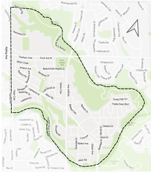
Map of a neighbourhood with a dashed boundary following Etobicoke Creek through surrounding residential streets. The creek and nearby green spaces are highlighted, with labelled roads and neighbourhood areas shown within and around the boundary.

Public and interest group opinions, along with technical and policy considerations, are used to inform City staff recommendations and decisions to be made by City Council. Public Consultation took place over two phases.

  • Phase 1 (April to June 2025): presented background information and consulted the community on issues commonly experienced in the neighbourhood and ideas for actions and changes.
  • Phase 2 (March to April 2026): consulted the community on proposed short-term actions (one to two years) which can be made using temporary, flexible materials like signs, paint, and bollards, and will identify longer-term changes which can be accomplished alongside future programmed road work.

Phase 2:

View the public consultation materials and Public Consultation Report summarizing all activities and feedback received:

Phase 1: Complete

View the public event materials and Public Consultation Report summarizing all activities and feedback received:

While we aim to provide fully accessible content, there is no text alternative available for some of the content on this page. If you require alternate formats or need assistance understanding our maps, drawings or any other content, please contact us at 416-808-2300 or email thistletownstreets@toronto.ca.

Neighbourhood Streets Plans (NSPs) service neighbourhoods where traffic and travel patterns challenge the safety and mobility of people using the streets. Through the NSP process, a team of City staff work with communities to identify local issues and opportunities, prioritize the greatest needs, and recommend changes to traffic operations and street designs. NSPs consider the needs of all road users and emphasize the safety of vulnerable road users such as seniors, school children, and people walking and cycling.

Each year dozens of nominations are received and five neighbourhoods are prioritized to participate in the program.

Thistletown was nominated for a Neighbourhood Streets Plan (NSP) by the Ward 1 Councillor in the 2024 NSP program cycle. Details of the nomination process can be found on the Neighbourhood Streets Plan web page.

NSPs follow several steps outlined below, and public consultation takes place in two stages.

  • Step 1: Public consultation on local issues & ideas
  • Step 2: Develop actions & changes to address issues
  • Step 3: Public consultation on proposed actions & changes
  • Step 4: Finalize plan for approval by Community Council
  • Step 5: Implement short-term actions *we are here*
  • Step 6: Monitor, evaluate, and update community on future changes

Neighbourhood Streets Plans result in short-term actions which can be made using temporary, flexible materials like signs, asphalt, paint, and bollards, and identify longer term changes which can be accomplished alongside future programmed road work.

The outcomes of each NSP are different based on local conditions and the needs of each neighbourhood. Generally, NSPs recommend actions related to motor vehicle speed and volume management, and traffic safety conflicts on local streets. NSP recommendations are informed by the City’s Traffic Calming Guide, Vision Zero Action Plan, and Complete Streets Guidelines.

Etobicoke York Community Council has approved installation of speed humps to address excessive speeding at the following locations:

  • Alhart Drive, between Calstock Drive and Thistle Down Boulevard
  • Amaron Avenue, between Taysham Crescent and Monterrey Drive
  • Bankfield Drive, between Albion Road and Calstock Drive
  • Barkwin Drive, between Islington Avenue and Thistle Down Boulevard
  • Benstrow Avenue, between Albion Road and Amaron Avenue
  • Calstock Drive, between Albion Road and Alhart Drive
  • Felan Crescent, near 44 Felan Crescent and Sangan Road
  • Gibson Avenue, between Barker Avenue and Sanderson Road
  • Harlow Crescent, entire street
  • Lakeland Drive, between Kipling Avenue and Lightwood Drive
  • Monterrey Drive, between Taysham Crescent and Beaumonde Heights Drive (east connection)
  • Panorama Court, entire street
  • Riverdale Drive, between Albion Road and Barker Avenue
  • Taysham Crescent, near 118 Taysham Crescent and Beaumonde Heights Drive
  • Wardlaw Crescent, between Islington Avenue and Barkwin Drive

Etobicoke York Community Council has approved installation of a raised intersection to improve safety for people accessing Albion Garden Park by increasing visibility for pedestrians and encouraging drivers to approach and travel through the intersection at lower speeds, at:

  • Intersection of Barkwin Drive and Batawa Crescent

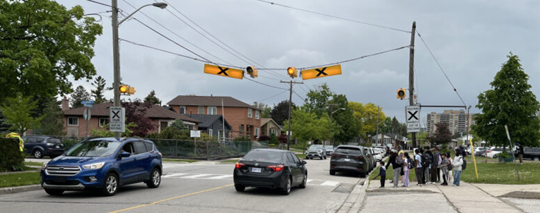
Etobicoke York Community Council has approved the following changes to address safety near schools:

  • U-turn prohibition to improve safety for students on Monterrey Drive
  • Curb Extensions at existing pedestrian crossings: to enhance visibility of pedestrians at or approaching the crossing and shorten crossing distances for pedestrians​, at:
    • Intersection of Thistle Down Boulevard and Monterrey Drive
    • Intersection of Thistle Down Boulevard and Judhaven Road

    Additionally, speed humps have been approved for Calstock Drive and Monterrey Drive to respond to excessive speeding. See the section on Excessive Speeding for more details.

    Etobicoke York Community Council has approved the following changes to active transportation:

    • New crosswalk markings at intersections with all-way stop signs to improve pedestrian safety, at:
      • Amaron Avenue and Benstrow Avenue
      • Monterrey Drive and Taysham Crescent
      • Monterrey Drive and Waltham Drive
      • Barkwin Drive and Batawa Crescent
      • Barker Avenue and Riverdale Drive
    • Relocation of the TTC bus stop at the intersection of Islington Avenue and Finch Avenue West from south to north corner of Finch Avenue West to improve accessibility for transit users

    City Council has approved the following improvemetns to active transportation on Panorama Court and Rowntree Road:

    Panorama Court
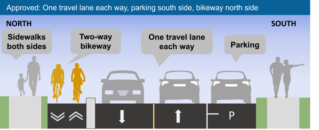
    • Road design that discourages speeding (including speed humps and reducing lane widths to City’s standard)
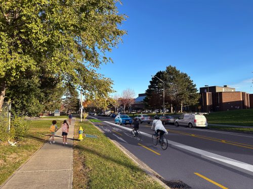
    • New two-way bikeway on north side of street, physically separated from the motor vehicle lane with a concrete barrier
    • Consolidate parking onto south side of street with a total of 38 spaces​.
    • Potential removal of 6 to 8 small trees, that would be replaced with three times as many new ones
    • No change to number of motor vehicle lanes

    Illustration of the approved changes, with sidewalks on both sides of the street, a two-way bikeway on north side, parking on south side, and one travel lane in each direction

    Rendering showing the proposed changes on Panorama Court, including a two-way bikeway on north side of the street, and parking on south side
    Artistic rendering showing approved changes on Panorama Court


    Rowntree Road

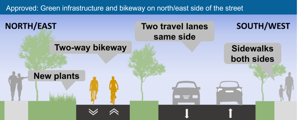
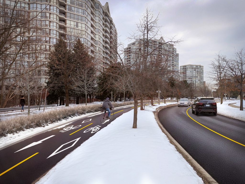
    • Convert the northeast side of the median to the two-way bikeway with new plantings that support stormwater management
    • Move both motor vehicle lanes on the southwest side of the median​
    • Road design that discourages speeding (such as reducing lane widths to City’s standard)
    • Potential removal of 6 to 8 small trees, that would be replaced with three times as many new ones
    • No change to number of motor vehicle lanes

    Illustration of the approved changes, with new plants and a two-way bikeway on north/east side of the street, two travel lanes on south/west side, and sidewalks on both sides

    Artistic rendering for proposed Option 2 for Rowntree Road with north-east side of the median converted to a two-way bikeway with new plantings and both directions for motor vehicles on the south-west side of themedian​
    Artistic rendering of the approved changes for Rowntree Road

    Etobicoke York Community Council has approved the installation of an all-way compulsory stop control at:

    • Intersection of Bankfield Drive and Alhart Drive

    Residents have raised concerns about safety at and around the intersection of Islington Avenue and Albion Road.

    The City is planning road resurfacing projects on both Islington Avenue and Albion Road in the next 5+ years. Public feedback shared in Phase 1 of Thistletown Streets Plan will help inform this work and potential changes could include removing right turn channels, installing mountable curbs, and tightening the curb radii.

    Stay Informed

    The project team will keep local residents and businesses informed at key project milestones. Your information will be kept private and will only be used to notify you about this project.

    To receive project updates by email, please contact us and indicate that you would like to be added to the mailing list.


    Date modified: July 30, 2026