

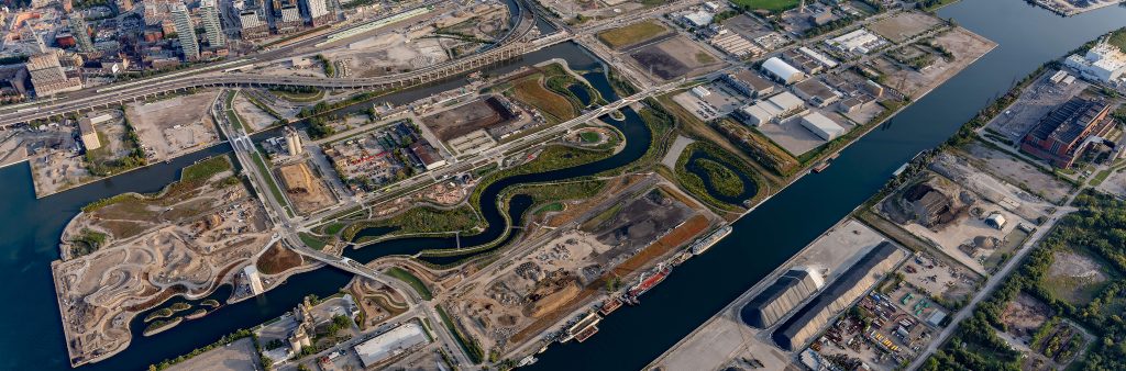
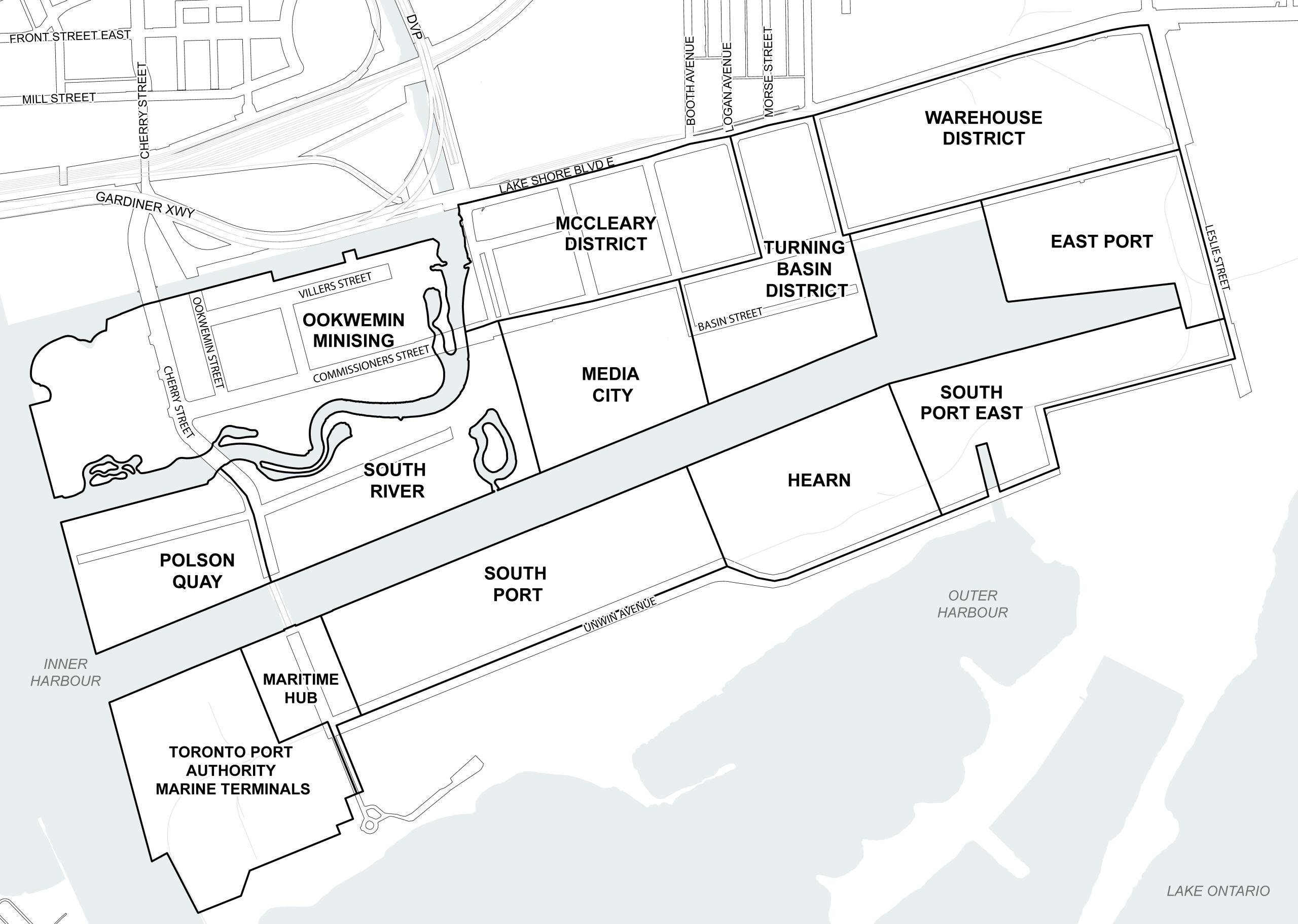
Toronto’s Port Lands cover about 356 hectares (880 acres), stretching from the Inner Harbour in the west, to Lake Shore Boulevard East in the north, Leslie Street in the east, and the Outer Harbour in the south.
The Port Lands were created in the early 20th Century by filling in Ashbridges Bay to create additional industrial areas for the growing city. Prior to this, the area was the largest natural coastal wetland on Lake Ontario and the Great Lakes region – a fertile wetland, fishing ground and important gathering place for Indigenous peoples who lived and travelled in the region. Today, the lands continue to be used for industrial and port functions, but there are large amounts of vacant and underutilized land.
The Port Lands are a significant long-term revitalization opportunity for the City, guided by a 50+ year vision set out in the Port Lands Planning Framework and implementing policies in the Central Waterfront Secondary Plan, approved by City Council in 2017 and by the Ontario Land Tribunal on July 11, 2022. Significant tri-government investment – $1.4 billion starting in 2017 and $975 million in 2025 – has been committed to implementation, with flood protection and enabling infrastructure to unlock development north of the Ship Channel, including in Ookwemin Minising.
The plan for the Port Lands makes room for a minimum of 40,000 people across four mixed-use neighbourhoods, at least 20,000 jobs in a diverse range of industries from film production to cargo handling, and creates new destinations at Biidaasige Park, along the Ship Channel, and at Polson Quay.
The following planning initiatives are underway in the Port Lands:
Future Precinct Planning includes Polson Quay, and South River.
The Port Lands Planning Framework provides a long-term vision to guide revitalization of the Port Lands. It envisions transforming the Port Lands into new, vibrant districts with unique and memorable local identities that promote social interaction, cultural enrichment, ecological health, a low-carbon future and a prosperous local economy. As the area continues to evolve, the Framework calls for celebrating and embracing its industrial history and active working port as a unique feature of its character.
The Port Lands Planning Framework is implemented through the Port Lands Area Specific Policy, which is part of the Central Waterfront Secondary Plan. The former City of Toronto Official Plan (1993) is in force for the Port Lands due to outstanding appeals to the Central Waterfront Secondary Plan.
For more information about the Port Lands, visit Waterfront Toronto’s Port Lands webpage and the Port Lands project page from CreateTO.
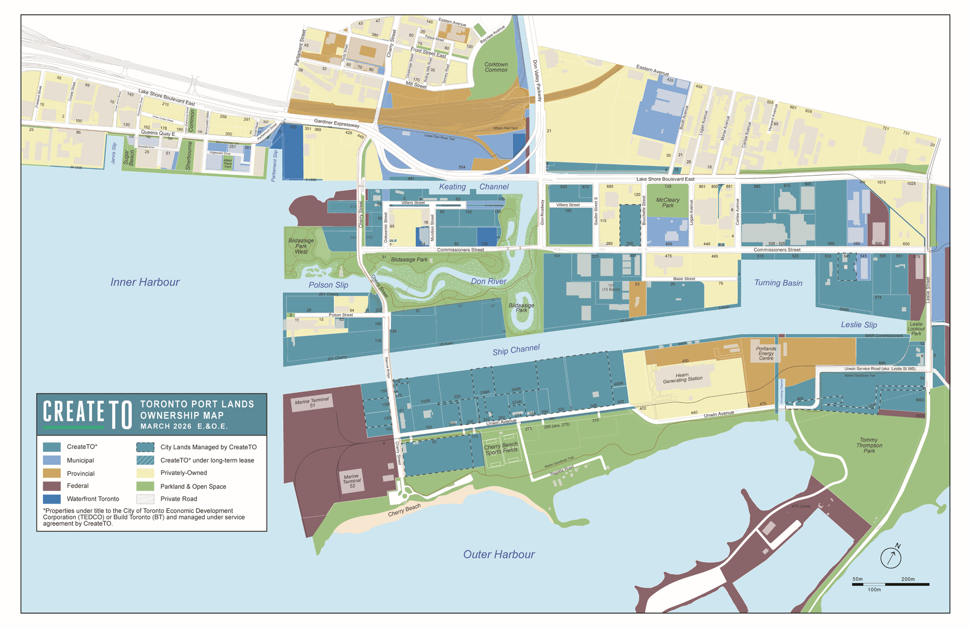
The largest property owner in the Port Lands is the City of Toronto through the Toronto Port Lands Company (TPLC), which is managed by CreateTO. The next largest landowners are the Province of Ontario and the Federal Government, through the Toronto Port Authority. There are also lands in private ownership. Waterfront Toronto owns several parcels on Ookwemin Minising.
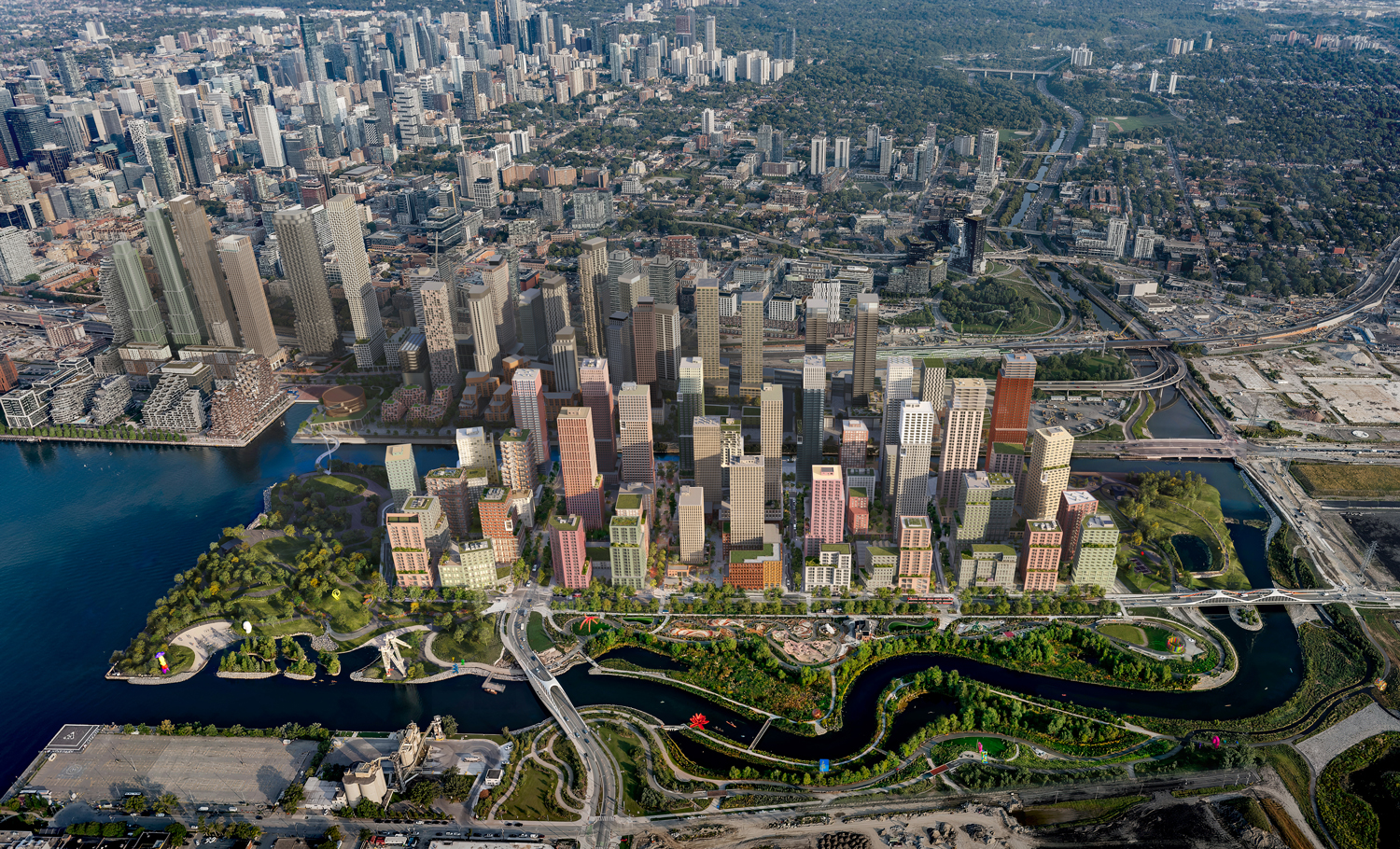
Ookwemin Minising is an island created through the Port Lands Flood Protection Project, which involved rerouting the Don River through a previous industrial area of the waterfront. Ookwemin Minising (pronounced Oh-kway-min Min-nih-sing) means “place of the black cherry trees” in Anishinaabemowin/Ojibwemowin. The island has a total area of 39.6 hectares, including 20.1 hectares of parkland, anchored by Biidaasige Park (pronounced Bee-daw-sih-geh) meaning “sunlight shining towards us” in Anishinaabemowin/Ojibwemowin.
The first Precinct Plan for Ookwemin Minising (formerly known as Villiers Island) was approved by City Council in December 2017 and envisioned a largely mid-rise island community. In June 2024, in response to Toronto’s Housing Action Plan, City Council approved an updated Precinct Plan together with Official Plan and Zoning By-law Amendments to provide for greater densities, in an inclusive, sustainable, and walkable urban community.
On May 21, 2026, City Council adopted an updated Precinct Plan and public realm vision for Ookwemin Minising together with implementing amendments to the Official Plan and Zoning By-law. The renewed vision builds on the planning and design foundation established through the approved Precinct Plan, carrying it into a greater level of detail, and informed by further Indigenous and public engagement. This work moves in step with the enabling infrastructure investments now underway, so that planning approvals and design direction are in place as implementation advances.
Information and Reports
Community Engagement
To learn more about engagement opportunities and activations on Ookwemin Minising, visit Waterfront Toronto's Ookwemin Minising webpage.
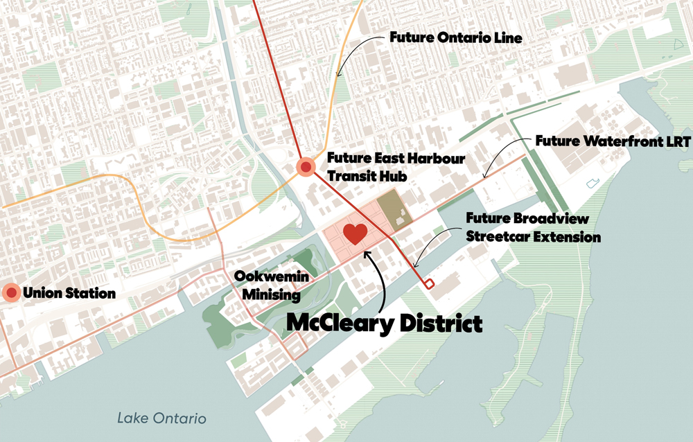
McCleary District comprises approximately 20 hectares (49 acres) east of Ookwemin Minising. It is bounded by Don Roadway to the west, Commissioners Street to the south, Lake Shore Boulevard East to the north, and Logan Avenue to the east.
McCleary District is envisioned to be a mixed-use community and a nexus of creative industry. Given that approximately two-thirds of the lands are in public ownership, the McCleary District represents an opportunity to advance city priorities related to affordable housing, Reconciliation Action Plan implementation, and economic development approaches that strengthen the cluster of creative industries in the area.
CreateTO is leading a precinct planning process in partnership with the City and Waterfront Toronto. The McCleary District Precinct Plan will provide more detailed direction for the District, building on the Port Lands Planning Framework and Central Waterfront Secondary Plan.
The Precinct Plan will establish local street and block patterns, locally-oriented parks and open spaces, the preferred location for community infrastructure, detailed urban design and streetscape guidelines, heritage, passive design, sustainability recommendations, and strategies for public art and affordable housing.
As a first step, a Framework Plan has been completed for McCleary District to provide greater guidance for the western portion of the district including four privately-owned sites. The next phase of work for the McCleary District is to undertake a detailed analysis of building massing and public realm to inform the final Precinct Plan and the implementing policy and zoning standards.
For additional resources on engagement and Precinct planning in McCleary District, visit McCleary District, CreateTO
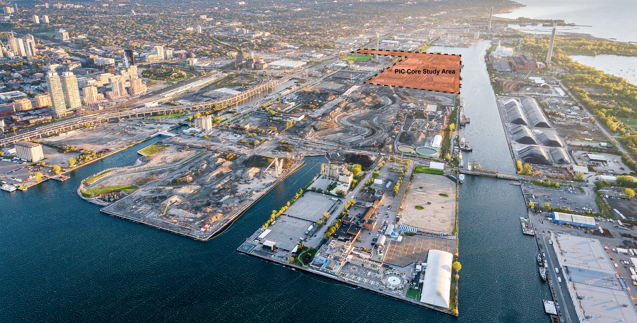
The City, in partnership with Waterfront Toronto and CreateTO, is developing Urban Design Guidelines for Production, Interactive and Creative (PIC) districts to further expand on the Council-adopted vision for the Port Lands for approximately 33 hectares of industrial land. This area will transform into two vibrant modern, urban districts that will become a creative industry hub, anchored by film and media campuses.
Media City and the Turning Basin are Production, Interactive and Creative (PIC) Core Districts in the Port Lands that are employment-focused with vibrant pedestrian-friendly streetscapes and a water’s edge promenade.
Media City is envisioned as a district for film, television and digital media production alongside other creative and supportive uses. Turning Basin will transition from light manufacturing and warehousing into creative uses.
In 2019, City Council approved updated zoning for approximately 200 hectares of employment-focused districts in the Port Lands – Turning Basin, Warehouse, East Port, South Port and Maritime Hub – as well as the parks and open space system. These by-laws were appealed to the Ontario Land Tribunal and are not in force for the Port Lands. Due to these appeals, Zoning By-law 438-86 remains in force for much of the Port Lands, as well as the Port Lands Interim Control By-law.
Information and Reports
Below are information and reports which apply broadly to the Port Lands (refer to tabs for District-specific reports)
Below is a list of active development applications and associated reports within the Port Lands. More information on each application can be found on the Application Information Centre and at the links below.