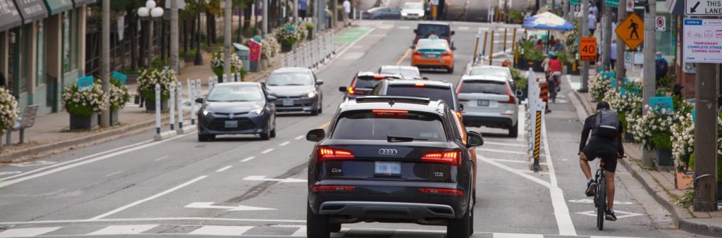
Yonge Street looking south from Woodlawn Avenue. Photo taken October 11, 2021.
Harry Choi
About the Project
In April 2021, Toronto City Council approved the installation of a temporary Complete Street Pilot on Yonge Street between Bloor Street and Davisville Avenue as part of the City’s Pandemic Mobility Recovery Strategy.
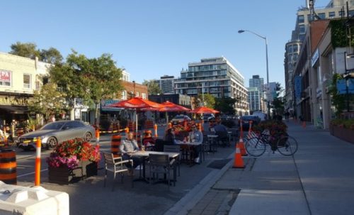
Yonge Street has been transformed into a complete street through the CaféTO and ActiveTO programs, which were both created in 2020 as quick-start COVID-19 response programs. CaféTO provided urgent support to hundreds of local restaurants and ActiveTO has connected the City’s cycling network like never before.
The pilot provides support for local businesses and surrounding communities by expanding outdoor patio areas, improving safety and comfort for everyone, and providing a safe and protected bike lane along the Line 1 subway.
City Council voted in favour of making the ActiveTO Midtown Complete Street Pilot permanent, with changes to address the immediate concerns of local residents and businesses.
City Council adopted the provisional continuation of the temporary ActiveTO 2021 Cycling Network Expansion Projects on Yonge Street (Davisville Avenue to 100 m south of Bloor Street cycle tracks) until January 2023.
April 7, 2021, City Council approved the General Manager, Transportation Services, to continue to consult, design, install and monitor the ActiveTO Midtown Complete Street Pilot in collaboration with the local Councillors and stakeholders and as part of the ActiveTO Cycling Network Expansion Projects.
Monitoring & Evaluation
The City is actively monitoring the ActiveTO Midtown Pilot through the collection of data on vehicle travel time, emergency response time and volume counts for vehicles, pedestrians and people cycling along the corridor.
The first data dashboard reflects data collected from September 2019 to June 2022 (released in August 2022).
The second data dashboard reflects data collected from September 2019 to August 2022 (released in November 2022).
The third data dashboard reflects data collected from September 2019 to November 2022.
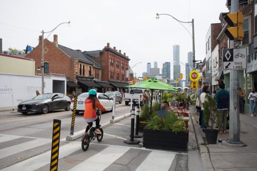
Travelling south on Yonge Street at Scrivener Square. Photo taken October 11, 2021.
Consultation has taken place before and during the pilot with key stakeholders and the public to gather input and feedback, and to help inform design modifications as well as
Five virtual stakeholder meetings with representatives from over 27 local organizations have been held since March 2021, and six site walks with stakeholder groups were held in 2022. The feedback from these meetings led to changes to side street parking and signal improvements, new left turn lanes, and new signal timing across the corridor. The feedback also led to the development of the publicly accessible data dashboards.
Since March 2021, there have been five stakeholder meetings and site walks with BIAs along the Yonge Street corridor. The feedback from these meetings with BIAs led to a number of design changes including changes to parking, loading, new left turn lanes, new CaféTO locations and designs. Following the end of the 2022 CaféTO season, two BIAs in the project area provided feedback to the project team on specific aspects of the design of the pilot.
In April 2021, Transportation Services conducted a Parking and Loading Needs Survey for businesses along the corridor. Over 80 businesses participated. This information was used to inform the parking and loading design along the corridor.
In April 2021, prior to implementation of the pilot, a Virtual Public Meeting was held. Over 300 people attended the meeting. An online feedback survey was also released after the event, which received over 300 responses.
In partnership with the The Centre for Active Transportation (TCAT) and Park People, Transportation Services carried out a before-and-after public intercept survey, with over 1,145 in-person surveys completed. As part of the public intercept survey process, an additional day of accessibility-targeted surveying was conducted to learn about the experiences of both Wheel-Trans users and driver operators. An additional targeted focus group was hosted for food delivery workers, as many were busy working when the researchers were in the field and were underrepresented in the intercept surveys.
There have been two staff reports to the Infrastructure & Environment Committee and City Council, providing the public with two opportunities to submit written and spoken public comments. There were separate reports to both TTC and the City’s Accessibility committees.
City staff have participated in BIA annual general meetings, and resident association meetings upon request, in addition to tracking and responding to hundreds of emails and phone calls (approximately 400 emails).
Stakeholder Meetings
Stakeholder groups who could be impacted by the pilot were invited to provide feedback throughout the project and represented a variety of interests including residents, businesses, institutions, and road users, among others.
Meeting 1
The project team first met with stakeholders on March 15, 2021, to introduce the project and receive initial input. Read Meeting 1 Notes
Meeting 2
The project team met with stakeholders on April 9, 2021 to provide an update on CaféTO registrations and preliminary designs including cross-sections and elements. Read Meeting 2 Notes
Meeting 3
The project team met with stakeholders on May 11, 2021 to provide a block-by-block overview of the draft design plan. Read Meeting 3 Notes
Meeting 4
The project team met with a smaller group of stakeholders on May 27, 2021 to address concerns about three intersections including: Yonge St. and Alymer Ave.; Davenport Rd. and Church St.; and Yonge St. and Yorkville Ave. Read Meeting 4 Notes
Meeting 5
The project team met with stakeholders on October 18, 2021 to provide a progress update and receive feedback post installation to help inform the staff report to Council in April 2022. Read Meeting 5 Notes
Stakeholder Site Walks
Since May 2022, eight site walks have taken place with stakeholders to receive feedback on the pilot and discuss site-specific observations and concerns. Stakeholders included five local resident associations, two active transportation groups, one BIA and one church located in the study area. While some stakeholder groups indicated support for the pilot, others expressed a desire to see the removal of the cycle tracks from Yonge Street.
Key feedback included:
Excitement about the pilot and feedback that the project has made travel by bicycle easier, safer and more comfortable;
Concerns about increased motor vehicle congestion on Yonge Street, leading to longer travel times and emissions from idling vehicles;
Appreciation for the streetscaping elements, such as planters, and a desire to see additional features in the future;
Some participants noted that they use the cycle tracks daily for commuting to work, school drop-off, shopping, and other short-distance and long-distance trips;
Challenges for drivers making turns to and from ‘land locked’ local streets as a result of traffic volumes on Yonge Street and increased parking on side streets, and a desire to see additional turning lanes or traffic signals;
Questions about the City’s plans for accommodating future population growth and transportation demand from proposed and planned developments on Yonge Street;
A desire to work collaboratively with the City to address concerns and identify solutions;
Concerns that emergency services response times may be impacted by the pilot, particularly for ‘land locked’ streets;
Requests for design modifications to further enhance safety for pedestrians and people cycling, as well as modifications to improve traffic flow;
Concerns about the impact of the pilot on business deliveries and loading activities, as well as parking and passenger drop-off and pick up; and
Requests for more detailed data and analysis of traffic volumes.
Comments received through the site walks led to a number of modifications to the design of the pilot, as well to additional monitoring and data analysis.
Virtual Public Meeting
The City hosted a virtual public meeting on April 27, 2021. The meeting was attended by over 300 participants.
Before-and-after studies will include a safety review (collision data within and adjacent to corridor), volumes for all modes at key intersections (motor vehicles, people walking and people on bikes) and travel time analysis. Pending public health restrictions, intercept surveys will be conducted to understand the user perspective of the Yonge Street Midtown Complete Street Pilot with particular attention to vulnerable road users, and increasing safe and equitable access to active modes of transportation.
Turn restrictions to local streets:
Minimizing impacts to local traffic patterns on side streets is a key consideration in the design. The design will consider: signal coordination and timing to reduce the attractiveness of traffic diversion onto local streets; traffic calming at intersections to deter short-cutting; and turn restrictions at strategic intersections.
Ensuring transit reliability when the subway is closed:
Transportation Services continues to work with TTC staff to ensure the design adequately accommodates TTC bus stops, minimizes the impact to transit, and improves the street environment for transit users. Wheel-Trans and accessibility needs are also key considerations in the proposed design.
TTC prioritizes keeping customers moving upon any closures and identifying key locations to move buses more quickly. In particular, the retention of a second southbound travel lane between Davisville Avenue/Chaplin Crescent and Heath Street will help keep service moving. As part of normal subway shuttle operations, TTC works with TTC agents as well as Toronto Police to have police assistance in moving buses through busy intersections where delays can occur.
Safety
EMS vehicles during blocked one lane situations:
Fire, Paramedic and Police Services staff are part of the City’s internal and agency circulation process on the detailed design and safe access for emergency vehicles is a fundamental part of the project design process. Staff use a number of tools, standards, and guidelines to support vehicle maneuverability, while balancing road safety. These tools include vehicle turning “swept path” simulations, as well as roadway standards and the City of Toronto’s Lane Width Guidelines, which were developed in consultation with emergency services.
Vision Zero principles included:
The Vision Zero Road Safety Plan is a guiding principle and works to prioritize vulnerable road users with initiatives like separated space for people on bikes; artistic curb extensions to reduce crossing distances; and ensure drivers turn slowly. Signal timing as well as loading and parking strategies will also help avoid accidents.
Staff are reviewing design options to control speeds and ensure safe interactions between all people using the street.
Avoiding conflicts for cyclists (especially going downhill):
Studies from Toronto and other cities have shown that by introducing cycling infrastructure, speeding by drivers decreases and thus reduces the number of collisions. This benefits all road users, especially the most vulnerable.
Speed limit:
Staff is recommending reducing the speed limit to 40km/h within the pilot area which will be presented to the Infrastructure & Environment Committee Meeting on May 25, 2021.
Incorporating intersection improvements for pedestrians and accessibility:
Locations for accessible parking, pick-up and drop-off are under review.
Maintenance
Street cleaning:
In Spring 2021, Transportation Service’s Operations and Maintenance Section will commence a pilot program using city crews for dedicated inspection, maintenance and localized repairs on bikeways to meet the growing demand for a proactive maintenance program.
Debris removal from bike lanes:
The City will regularly sweep the cycle tracks. The goal is to maintain them every other day, but will depend on potential delays with the purchasing of additional sweepers.
Snow maintenance, including the cycle tracks, will be conducted as needed.
Maintaining damaged items:
There will also be contractors responsible for regularly maintaining and watering planters.
Business and CaféTO
Considering switching café section with existing sidewalk:
One of the primary principals of the CaféTO program is the need to ensure that our sidewalks remain accessible for all users. It is important that pedestrians have a straight and predictable path of travel, especially for those with no or low vision so that people using our sidewalks can travel safely.
Separating cafés from traffic lanes:
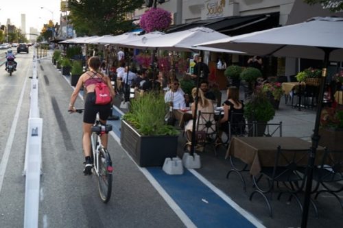
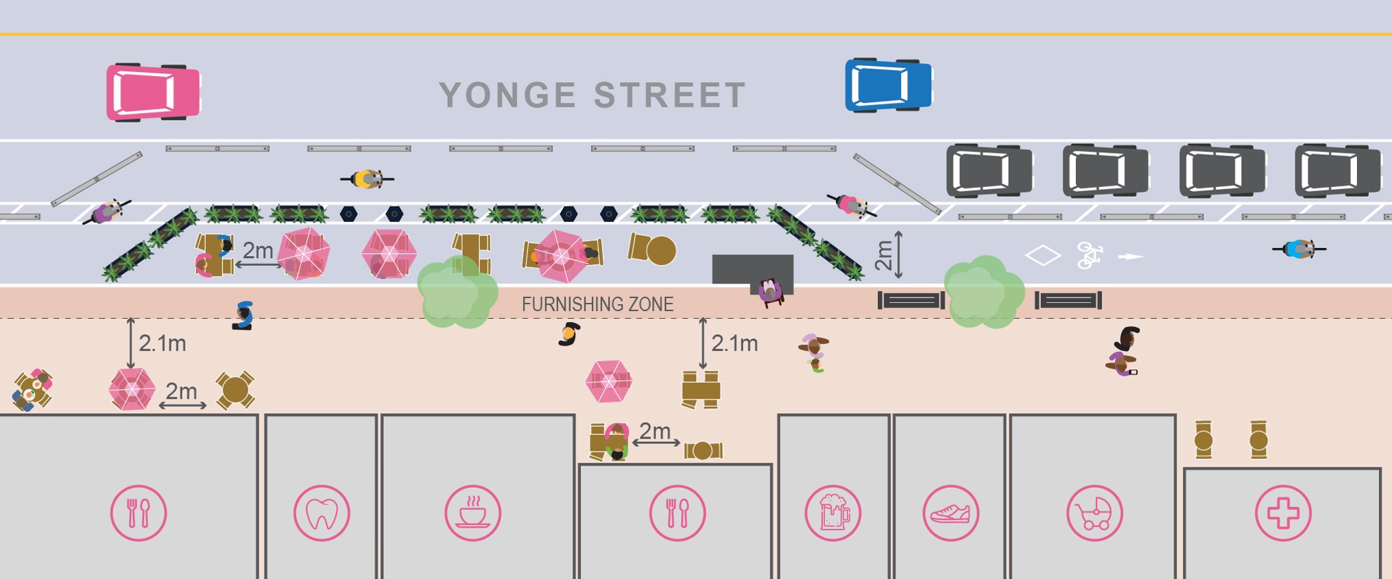
Cafés will be surrounded by the bike lanes. The bike lanes will be protected from vehicular traffic with concrete curbs and posts. There will be black planters and posts separating the bike lane from the cafe areas. The enclosures will be robustly protected with buffer space (bike lane) between cafés and traffic.
Where there are curb lane cafés, the speed limit will be 40 km/h.
Pilot providing for temporary stopping for food delivery drivers and ride hail:
Loading and parking will be provided along the corridor.
Retailers using outdoor sidewalk space for commerce:
There is an opportunity for retailers to access, without registration or application, space on the sidewalk with requirements that store owners must maintain, including maintenance of the pedestrian path of travel on the sidewalk, and certain size restrictions. More information on small marketing displays available in the 2021 CafeTO Guidelines.
Reference Projects & Lessons Learned
Using lessons learned from other projects to inform design on Yonge Street:
It is important to monitor and make adjustments on an ongoing basis in order to respond to different needs. For example, concerns related to lane reductions resulting in an increase or traffic on parallel streets can be addressed with turn lane restrictions as well as employing traffic data and multi-mode counts to inform the design modifications.
Installation of bollards onto curb stones is preventing some of the issues with the flex-posts.
COVID-19 Considerations
Considering social distancing on sidewalks (sometimes narrow):
Public Health restrictions will guide the opening of CaféTO.
Staff have been working with Business Improvement Area’s to identify street cluttering and the city is reviewing the removal of obstacles that impede pedestrian movement.
Public Realm
Pilot introducing more green space:
Streetscape plans will include hundreds of planters along the corridor with perennial planting along the cafés and along the cycle tracks with regular maintenance.
Opportunities for artwork and beautification:
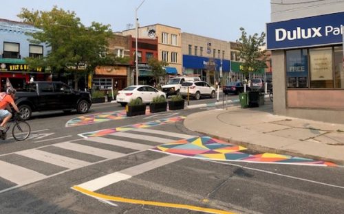
We will be integrating “artistic curb extensions.” These street murals will be designed to reflect the different characters of Yonge Street while helping improve pedestrian safety.
Implementation
Determining final configuration and building cafés before the bike lane:
The first window of curb lane CaféTO installations has been completed and businesses await the lifting of COVID-19 restrictions to offer outdoor dining.
Building now since everything is closed and street closures:
The Complete Street Pilot will be installed in late June. Design details are being finalized in consultation with internal partners, agencies and stakeholders including Business Improvement Areas (BIA), resident associations and community organizations. The design will be finalized by June and installation is planned for June/July. Curb lane cafés will be temporarily closed during the install. Partial lane closures will occur between June 13 and 30 for essential elements. Priority will be given to minimize CaféTO disruptions. Green markings and artistic curb extensions will follow in July.
Big decisions to make the project permanent:
Staff will conduct a Before and After Study (including safety, volumes, travel time and public perception) and report back to Council in early 2022.
Public Consultation
There are several ways to participate in meetings from submitting a question via typed Q&A, using the raise hand function (phone and computer) or sending feedback to the project email or phone line in advance.
Enabling chat function during meeting so community members can discuss topics amongst themselves:
During our virtual meetings, the Question and Answer panel is used in place of the Chat function so that staff can manage and respond to volume of questions and comments from participants. It would be a challenge to monitor both dialogue boxes for acceptable use such as use of coarse language, aggressive comments, intimidation or harassment.
All questions and comments received, and issues that are not responded to live in the meeting are followed up with through future project updates.
Need assistance? While we aim to provide fully accessible content, there is no text alternative available for some of the content on this site. If you require alternate formats or need assistance understanding maps, drawings or any other content, please contact us: Stephanie.GrisBringas@toronto.ca or 416-392-3643.
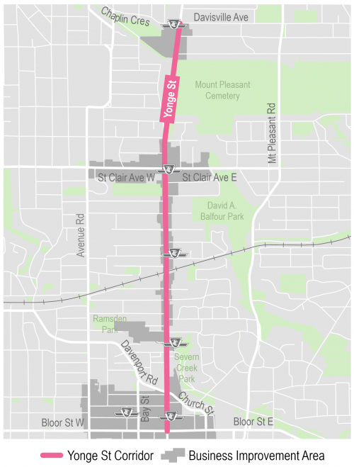
The pilot project area includes Yonge Street between Bloor Street as the south limit and Davisville Avenue as the north limit.
Corridor Comparison
In February 2021, Transportation Services completed a corridor comparison analysis of Mount Pleasant Road, Avenue Road and Yonge Street to determine the strongest corridor for a complete streets transformation pilot project.
Yonge Street was identified as the preferred corridor due to:
Highest potential for business benefits based on mixed-use land uses, employment along corridor and concentrations of BIAs compared to the alternatives
Demand for improvements as demonstrated through requests for CaféTO curb lane cafés as well as fewer anticipated parking impacts
Demonstrated need for safety improvements based on collision trends
Overall importance of the corridor to the cycling network considering the Cycling Network Plan prioritization process, topography and current bike share utilization
Policy support for complete streets and role of the corridor in placemaking along with lower vehicular volumes throughout compared to the alternatives
Yonge Street Corridor Overview
The ActiveTO Midtown Complete Street Pilot on Yonge Street between Bloor Street and Davisville Avenue (3.2 kilometres) was proposed in order to achieve:
A safer and more inviting street for all, including accessible features, additional pedestrian space, and streetscape beautification
Capacity relief to north-south Line 1 subway
Space for TTC bus stops and shuttles
New and expanded café options through CaféTO to support local restaurants
Dedicated space for vehicle and bicycle parking, loading / deliveries, and Bike Share stations
Protected bike lanes (cycle tracks) to connect people safely to their destinations and existing on street and off-street cycling routes
More room for physical distancing
Council Decisions
April 7, 2021, City Council approved the General Manager, Transportation Services, to continue to consult, design, install and monitor the ActiveTO Midtown Complete Street Pilot in collaboration with the local Councillors and stakeholders and as part of the ActiveTO Cycling Network Expansion Projects.
Supplementary report on TTC Impacts of the Complete Street Pilot included.
Transportation Services continues to work with TTC staff to ensure the proposed design adequately accommodates TTC bus stops, minimizes the impact to transit, and improves the street environment for transit users. Wheel-Trans and accessibility needs are also key considerations in the proposed design.
The Pilot may inform other local transportation aspects, such as potential Bus Rapid Transit routes as part of the Midtown Infrastructure Implementation Strategies in the Midtown in Focus Final Report.
Business-specific issues to be reviewed through BIA Site Walks (in compliance with public health restrictions) and addressed throughout pilot delivery and monitoring.
Every effort will be made for all restaurants and bars fronting Yonge Street in the Pilot area to receive a curb lane café, provided they meet all other requirements of the CaféTO program.
October 27, 2020, City Council approved the General Manager, Transportation Services, to consider and explore including, as part of either the 2021 update to the cycling network plan, the COVID-19 pandemic cycling network expansion response plan or potentially as part of the YongeTOmorrow process, a temporary protected bikeway along Yonge Street or parallel routes from Bloor Street to north of Lawrence Avenue in conjunction with on-street patios, road safety and traffic-calming measures, and other streetscape improvements identified through consultation with local businesses and community groups, following the complete streets approach applied to Danforth Avenue, with implementation by the second quarter of 2021, and iteration and evaluation throughout 2021.
July 23, 2018, City Council requested as part of Midtown in Focus that Yonge Street, Avenue Road and Mount Pleasant are Major Streets, identified in City Planning’s Midtown in Focus Yonge Eglinton Secondary Plan and Transportation Assessment, proposed to assess the feasibility of an optimal corridor(s) for dedicated (physically-separated) cycling infrastructure.
In April 2021, City Council approved extending the ActiveTO Midtown Midtown Complete Street Pilot on a provisional basis until January 2023 and directed staff to examine all intersections along the pilot project and make any changes deemed necessary to address traffic congestion, transit service, business, and accessibility issues arising from the project.
As part of the continuation of the Complete Street Pilot on Yonge Street from Bloor Street to Davisville Avenue, new left turn lanes were installed at three intersections to help improve traffic operations and safety within the pilot area.
Jackes Avenue/Farnham Avenue Southbound and Northbound Left-Turn Lanes
Shaftesbury Avenue Southbound Left-Turn Lanes
Roxborough Street West Northbound Left-Turn Lane
The new turn lanes have minor impacts on CaféTO space.
Additional Work
In addition to the new left-turn lanes, the following work has been carried out:
Enhanced pavement markings to better identify loading areas.
Pavement markings to encourage people cycling to slow down at key downhill locations.
Centre line modifications at Balliol Street to improve large vehicle manoeuvers.
Pilot Corridor Traffic Management System featuring advisory signage and corridor level signal timing adjustment capabilities.
CaféTO curb lane café installations. Planters and curb stones/bollards were relocated and used for cycle track detours around the cafés in Spring/Summer 2022.
The ActiveTO Midtown Complete Street Pilot will continue to be monitored to assess the before and after effects of these changes.
Streets are vital places in Toronto, now more than ever. They are also the common space where our city comes together. Streets are where children learn to ride bicycles, neighbours meet, and couples stroll. Streets are the front door of our businesses, homes, parks, and institutions. They form essential networks that move people and goods safely and efficiently in our growing city.
The ActiveTO Midtown Complete Street Pilot on Yonge Street, between Bloor Street and Davisville Avenue, is designed for people, for placemaking, and for prosperity.
Streets are for people
Streets are places where everyone should feel safe, comfortable, and connected.
Streets for placemaking
Streets should reflect the existing and planned function, scale and character of the neighbourhoods and communities that surround them, respecting the local context.
Streets for prosperity
Streets are vital to the economy and our city’s prosperity. Streets are the front door to many businesses and need to accommodate deliveries, goods movement and more.
A five kilometre stretch of Danforth Avenue installed in 2020 is demonstrating that using a complete streets approach can quickly deliver social, economic and environmental benefits to Toronto’s main streets.
The streetscape design elements for ActiveTO Midtown include:
Planters placed along curb lane cafés, ends of parking areas and other strategic locations
Painted buffer areas and flex posts on concrete curbs to separate the bike lane from parking and traffic
Curb extensions designed to visually and physically narrow the roadway at intersections, slow vehicle traffic and reduce the crossing distance, and provide more space for pedestrians
Accessibility features including shortened crossing distances, platforms at key locations, unobstructed loading for high use Wheel-Trans locations
Improved street environment for transit users and space for accessible TTC bus stops and shuttle locations