The Oakwood-St. Clair Parks Plan will guide short and long-term improvements to the park system in the Oakwood Avenue and St. Clair Avenue West neighbourhood. These improvements include park upgrades, the creation of new parks, and better access and connections between parks and other public spaces. The Plan was developed through community input and will be implemented through continued engagement and partnerships.
While we aim to provide fully accessible content, there is no text alternative available for some of the content on this site. If you require alternate formats or need assistance understanding our maps, drawings, or any other content, please contact Heather Oliver at 416-338-5831.
The Oakwood-St. Clair Parks Plan is available to the public. The Plan allows the City to take a strategic approach to creating and improving parkland in the study area. Visit the Oakwood-St. Clair Parks Plan section for more information.
On November 24, the project team hosted an open house with the goal of sharing study outcomes and preliminary recommendations and gathering insights from the community.
Download the open house presentation.
This summary showcases the insights and feedback collected through the extensive public and stakeholder engagement process. In the spring and summer of 2021 the project team collected ideas in a variety of ways, including a virtual mapping exercise (‘Social Pinpoint’), an online survey, classroom workshops with local high schools and a local stakeholder group workshop.
Download the Oakwood-St. Clair Parkland Study Summary Report
The project team held an online workshop in order to share preliminary findings of the community engagement exercises completed to date and to begin identifying key drivers and priority actions. The workshop was attended by Councillors for Davenport and Toronto-St. Paul’s and various community organizations.
As part of the study, the City conducted a virtual mapping exercise that allowed users to drop pins and indicate specific areas for improvement. The exercise received 700 comments and thousands of data points for the study.
As part of the study, the City conducted a survey to collect feedback and ideas from the community about parkland improvements in the study area. The survey received responses from 1,974 people.
The Oakwood-St. Clair Parks Plan is a roadmap for creating and improving parkland in the study area. The Plan provides direction on:
The Plan was informed by community feedback collected through a variety of engagement activities, including an online survey and mapping exercise, workshops, community group meetings and an open house.
The Plan identifies seven key directions and opportunities for the improvement of parks and open spaces in the Oakwood-St. Clair area, which include:
Download the:
The City of Toronto Parkland Strategy (adopted by City Council in November 2019) identified that the neighbourhood around the Oakwood Avenue and St. Clair Avenue West intersection is a priority area for parkland acquisition and improvements due to the low number of existing parks in the neighbourhood. As a next step, the creation of a detailed local parks plan was recommended.
The Oakwood-St. Clair Parkland Study will assess the neighbourhood to identify opportunities to improve existing parks, create new parks, and improve access and connections between parks and other public spaces. This includes exploring ways to make parks inclusive and welcoming spaces. The findings of this study will be used to inform decision-making and budgets for improvements to the park system in the area for years to come.
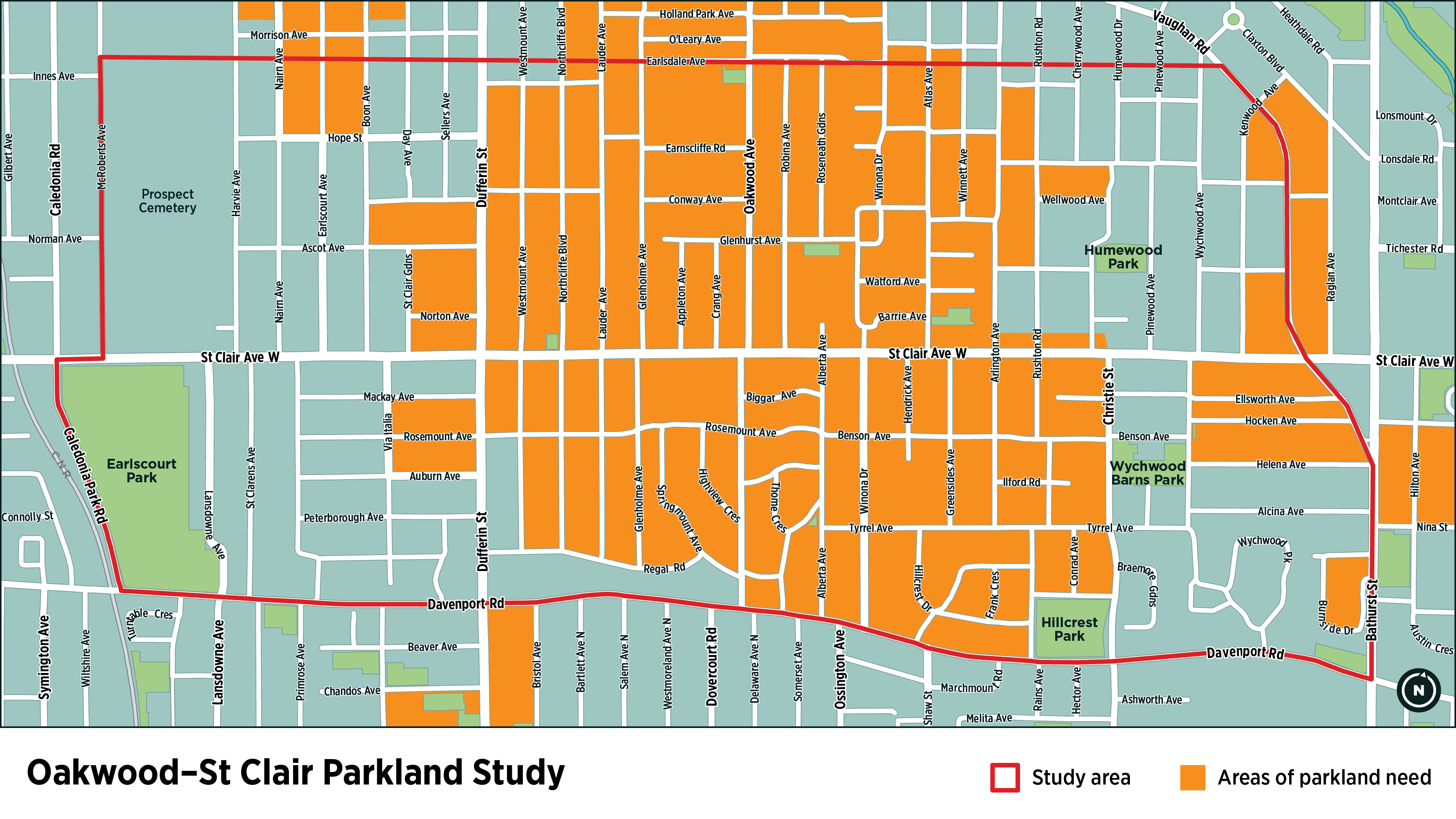
This study will investigate improvements to the park system in the area shown in the following map, with a focus on improvements that provide benefit to the priority area shown in orange.
This study complements several recent and upcoming improvements to Parks in the neighbourhood, including: