Some access points to Hanlan's Point Beach are temporarily closed due to high water levels. Please avoid the grassy dunes, as they prevent erosion and are especially vulnerable.
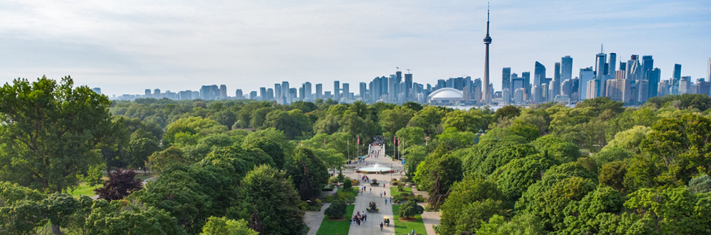
Following City Council’s adoption of the Toronto Island Park Plan in July 2024, the City is moving forward with projects to enhance and protect the park over time, guided by the plan’s long-term vision.
While we aim to provide fully accessible content, there is no text alternative available for some of the content on this site. If you require alternate formats or need assistance understanding our maps, drawings, or any other content, please contact Netami Stuart at 416-338-5901.
Sign up for or unsubscribe from updates related to Toronto Island Park Projects.
After the Toronto Island Park Plan was adopted in 2024, City Council directed City staff to continue engaging key audiences on the implementation by forming working groups that meet regularly.
These groups formed through a civic lottery bring together people with local knowledge and experience to work with City staff, explore issues and provide advice on projects identified in the Toronto Island Park Plan and on the overall management of Toronto Island Park.
In addition to the establishment of the three working groups, the City will continue to seek input from the broader public as new projects on Toronto Island are launched.
Meeting notes and presentation materials will be posted in this section after each working group meets.
Online Survey
From June 22 to July 20, an online survey collected feedback to help shape future recommendations for safety and wellbeing at Hanlan’s Point Beach.
A summary of the feedback will be posted on this page.
On January 31, members of all three working groups Indigenous Advisory Circle, Island Working Group and Hanlan’s Point Beach Working Group came together review their roles in supporting the implementation of the Toronto Island Park Plan and to get an overview of the projects they will help advise on in 2026.
A summary of the meeting will be posted on this page.
On December 3, a virtual public meeting was held to share insight into the Bike Share operations on Toronto Island in 2025, share the Bike Share Pilot’s Survey findings and learn from people’s experiences. A summary of the meeting will be posted on this page.
From August 8 to October 15, an online survey collected feedback to help inform future improvements to Bike Share on Toronto Island Park.
A summary of the feedback will be posted on this page.
The Hanlan’s Point Beach Working Group was formed to provide advice on projects and priorities relevant to 2SLGBTQ+ communities, both at Hanlan’s Point and across the Toronto Islands. The group includes about 20 members, made up of individuals with diverse backgrounds and connections to Hanlan’s Point Beach, as well as representatives from organizations that reflect broader communities.
On March 7, the Hanlan’s Point Beach Working Group met to review several Toronto Island Park Plan projects, with a focus on Hanlan’s Point. Discussion covered the Ferry Landings Revitalization project, Hanlan’s Beach Renourishment, the Hanlan’s Point Beach Community Safety and Wellbeing Plan, and the Hanlan’s Landscape Design and Servicing work. Participants also discussed 2026 planting considerations and explored how these projects can be coordinated to support ecological resilience, 2SLGBTQ+ safety and cultural significance, and an improved visitor experience at Hanlan’s Point.
A summary of the meeting will be posted on this page.
On November 5 and December 6, the Hanlan’s Point Beach Working Group met to reconnect and discuss and workshop a Draft Terms of Reference for the Working Group. A Terms of Reference is a brief guide that explains a working group’s purpose, responsibilities, and decision-making process. It is a tool that will help the working group stay focused, accountable, and effective. Meeting summaries will be posted shortly.
Download the November 2025 Hanlan’s Point Beach Working Group meeting summary.
Download the December 2025 Hanlan's Point Beach Working Group meeting summary.
On June 23, the Hanlan’s Point Beach Working Group met to reconnect, review recent actions and establish priorities for moving forward. Participants, representing diverse communities and long-time stewards of the beach, emphasized Hanlan’s cultural, historical and personal significance, especially for 2SLGBTQ+ communities. Key themes that emerged from this meeting included:
While differences of opinion emerged – particularly around safety approaches and the role of facilities – the group expressed a strong commitment to collaboration, transparency and amplifying marginalized voices.
Download the June 2025 Hanlan’s Point Beach Working Group meeting summary.
The Indigenous Advisory Circle will reflect a diversity of Indigenous voices, perspectives, and interests in Toronto Island Park. Its structure, membership and guiding protocols will be shaped by the advice and interests of First Nations. The work of this group is a step toward shared decision-making and co-management of Toronto Island Park spaces.
On March 9, the Indigenous Advisory Circle met to review several Toronto Island Park Plan projects, with a focus on Indigenous placekeeping, cultural protocols and early project direction. Discussion included an update on the draft Knowledge Sharing Protocols, the Ferry Landings Revitalization project and the proposed Snake Island Ceremonial Space. Members also received updates on several Hanlan’s Point projects, including Beach Renourishment, the Community Safety and Wellbeing Plan, Landscape Design and Servicing work, and 2026 planting. The meeting provided an opportunity for members to share early guidance on how these projects can better reflect Indigenous values, support respectful collaboration and advance implementation of the Toronto Island Park Plan.
A summary of the meeting will be posted on this page.
On November 25, the Indigenous Advisory Circle met for the first time. Advisory members had a chance to introduce themselves, meet the project learn, learn about the Toronto Island Projects and discuss how the membership wants to work together.
Download the November 2025 Indigenous Advisory Circle meeting summary.
The Island Working Group brings together a wide range of voices, including island residents, waterfront users, city-wide organizations, local businesses and advocacy groups. It also includes members selected through a civic lottery to ensure participation from underserved and underrepresented communities. The group provides input across all the goals of the Toronto Island Park Plan.
On March 12, the Island Working Group met to review and discuss several Toronto Island Park Plan projects related to access, movement and public experience across the Island. The meeting included discussion on the Ferry Landings Revitalization project and the Island Movement Strategy, followed by updates on several Hanlan’s Point initiatives, including the Hanlan’s Landscape Design and Servicing work and Beach Renourishment. Members had the opportunity to share feedback on early project analysis, emerging priorities, and how these projects can improve access, wayfinding, mobility, and overall visitor experience while aligning with the broader goals of the Toronto Island Park Plan.
A summary of the meeting will be posted on this page.
On November 20, the Island Working Group met to as a full group (original CAC and new Island Working Group civic lottery members) to meet one another, learn about the Toronto Island Projects and discuss and workshop a Draft Terms of Reference for the Working Group.
Download the November 2025 Island Working Group meeting summary.
From October 3 to November 2, community members could apply to join the Island Working Group and help guide the implementation of the Toronto Island Park Plan. The Island Working Group will support the City’s project team by sharing feedback and ideas to ensure the Islands remain inclusive, welcoming and vibrant for all Torontonians.
On June 25, the Community Advisory Committee involved with the development of the Toronto Island Park Plan met to review progress, confirm ongoing participation and prepare for the Committee’s transition into the broader Island Working Group. Members emphasized protecting the Island’s unique character, culture, and ecology while balancing diverse needs such as public access, resident well-being, and visitor experiences. Key priorities discussed during the meeting included:
Participants also stressed the importance of clear mandates, inclusive representation, transparent data-sharing and well-structured meetings.
Download the June 2025 Toronto Island Park Plan Community Advisory Committee meeting summary.
A civic lottery is a way to fairly select a group of everyday people to help guide public decision-making. People are chosen at random so the group reflects the full diversity of the city. This ensures that the people most affected by public spaces have a real voice in shaping them.
For the Toronto Island Park Working Groups, the civic lottery creates groups that reflect a range of voices, experiences and perspectives. The selection process uses citywide census data to ensure a mix of ages, backgrounds, incomes and neighbourhoods, with a special focus on including people whose voices have often been left out, especially those with a strong personal, cultural or historical connection to the Island.
This project is focused on improving the three Island-side ferry landings at Hanlan’s Point, Centre Island and Ward’s Island. The work includes background research, site inventory and analysis, development of early design and recommendations for phasing and implementation. The project is intended to improve accessibility, wayfinding, visitor experience, passenger movement and overall arrival to Toronto Island Park, while also strengthening each landing’s unique identity and aligning with broader Island initiatives. This phase of work is focused on planning and concept development and does not include detailed design or construction.
Project Timeline
A coordinated series of projects is underway across Hanlan’s Point Beach, focused on supporting the long-term ecological health, cultural significance, safety and visitor experience of the area. This work includes beach renourishment and shoreline resilience planning, ecological restoration and re-naturalization, landscape and servicing improvements, upgraded wayfinding and signage, and the development of a Community Safety and Wellbeing Plan. Together, these projects are intended to ensure that future improvements to Hanlan’s Point Beach are connected, responsive and grounded in the unique identity of the beach and surrounding parkland.
The projects are being advanced together because decisions about the physical landscape – including lighting, pathways, beach access, gathering spaces, amenities, signage, ecological restoration and servicing infrastructure – all contribute to how people experience safety, belonging, accessibility, comfort and care within the space. The work also recognizes the importance of protecting and strengthening the environmental resilience, cultural identity and community-defined character of Hanlan’s Point Beach for current and future generations.
More information about each project is provided below.
Work is underway on a strategy to address shoreline erosion and improve coastal resilience at Hanlan’s Point Beach. The work aims to better protect and restore beach areas impacted by erosion, while balancing ecological protection, shoreline function, public access and the cultural significance of Hanlan’s as an important 2SLGBTQ+ gathering place. The project will improve understanding of coastal processes, identify appropriate renourishment approaches and plan proactively for the long-term stewardship of the beach.
This project will develop a landscape implementation plan for Hanlan’s Point Beach and surrounding areas that brings together existing conditions, 2024-2025 Improvements, re-naturalization work and proposed future improvements. It is intended to coordinate multiple overlapping projects and identify how future improvements – such as servicing, amenities, furnishings and public realm upgrades – can be delivered in a more integrated way. Potential actions within the scope of the plan may include Rainbow Road improvements, revised picnic area mapping, relocated amenities, electrical and water servicing, beach showers and drinking fountains, and recreation opportunities.
The Community Safety and Wellbeing Plan is focused on supporting a safe, welcoming, inclusive and culturally respectful environment at Hanlan’s Point Beach. The plan recognizes that safety and wellbeing are shaped by many interconnected factors, including the physical environment, lighting and visibility, beach access and movement, ecological conditions, amenities, social dynamics and people’s experiences of belonging and care within the space. The work also acknowledges the unique cultural significance of Hanlan’s Point Beach as a longstanding 2SLGBTQ+ and clothing-optional gathering space.
The plan is being developed alongside other ongoing Hanlan’s Point Beach projects, including beach renourishment, ecological restoration and re-naturalization, landscape and servicing improvements, and signage and wayfinding enhancements. Through research, technical analysis, environmental review and community engagement, the project will help guide future improvements that support the long-term environmental health, cultural significance, accessibility, safety and visitor experience of Hanlan’s Point Beach.
Over the winter and spring of 2024-2025, in response to direction from City Council, the City made significant changes to the landscape and access points to the Clothing-Optional Beach at Hanlan’s Point. These improvements aim to restore the area’s ecology and preserve the history and culture of Hanlan’s Point Beach and its surroundings.
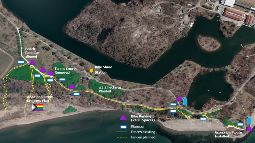
Improvements completed from 2024-2025 include:
This project will examine how people move through Toronto Island Park and where roads, paths, or travel conditions may feel unsafe or uncomfortable for different users. The study is intended to identify opportunities for low-cost, high-impact “quick win” improvements in the near term, while also laying the groundwork for a broader Park Movement Study. The work will help inform improvements to safety, accessibility, and connectivity across the Island for different travel modes.
This project is exploring the creation of a ceremonial space on Snake Island as part of the Toronto Island Park Plan’s commitment to Indigenous placekeeping, reconciliation, and revealing an Indigenous place. Early discussions are focused on identifying the City’s first steps in advancing the project and gathering guidance from First Nations and the Indigenous Advisory Circle on how the work should proceed respectfully and in alignment with Indigenous values and protocols.
In 2026, the City will begin the hiring process for an interpretive planning consultant with Indigenous design leadership. The consultant will lead a collaborative process to help articulate stories, identify cultural and natural heritage features, and set priorities for interpretation and site-specific approaches to interpretive media.
This process will result in the design of the first phase of interpretive assets on the Island.
In late 2024, the Toronto and Region Conservation Authority (TRCA), in partnership with the City, completed the Environmental Study Report for the Toronto Island Park Flood and Erosion Mitigation Class Environmental Assessment.
The next step is to begin detailed design, coordinated with and in support of the Toronto Island Park Plan. High-level updates will be posted on this page, with full project details available on TRCA’s Toronto Island Park Flood and Erosion Mitigation.
The Toronto Island Plan includes recommendations to guide improvements over the next 25 years. These recommendations are organized under six goals that work together to address the complexity and opportunities for Toronto Island Park. Each goal is supported by strategies and actions that provide a clear roadmap for investment, partnership, engagement, and other steps needed to achieve the Plan’s long-term vision.
Download the:
The Toronto Island Park Plan was co-created with Indigenous rights holders, local communities and the public through a series of engagement activities held between 2021 and 2024. In total, more than 4,500 people participated in activities such as Indigenous engagement and placekeeping meetings, virtual and in-person events, stakeholder discussions and a youth ambassador program.
The following provides a high-level overview of the engagement process.
To help shape the early stages of the Plan, the City held pre-engagement focus groups and interviews with Indigenous communities, local organizations, City divisions and partner agencies. These conversations helped build a preliminary understanding of key issues, existing conditions and opportunities on the Toronto Island
The pre-engagement phase also included a Public Life Study, which looked at how the Island is used, and a storytelling project that invited residents and visitors to share their personal connections to the Island.
These early activities introduced the project and helped shape how communities wanted to be involved throughout the planning process.
Download the:
This phase focused on developing a shared vision, values and guiding principles to inform the Plan. The What We Heard Summary Report brings together key insights and outcomes from all engagement activities and tools used during this phase.
Download the Phase 1 What We Heard Summary, Toronto Island Park Plan.
This phase built on the collective vision, values and guiding principles developed in Phase 1 to identify Big Ideas and develop a Draft Demonstration Plan. The What We Heard Summary Report summarizes the insights and outcomes from all engagement activities and tools used during this phase.
Download the:
This phase focused on confirming the direction of the Plan by refining the Demonstration Plan, shaping site-specific approaches, and identifying priorities for implementation.
Download the: