June 2025 update: Project implementation has been placed on pause while the City of Toronto reviews the project’s impact on other active projects in the area.
The project is part of the 2025 to 2027 Cycling Network Plan Near-Term Implementation Program. The road safety improvements and bikeways are planned to be installed at the same time as road repair work. In addition to closing the gap between the existing trail network, this project connects to the existing Marlee Avenue bikeway and future cycle tracks as part of the eglintonTOday Complete Street Project. The changes include:
On May 22, 2025, City Council approved the Member’s Motion (2025.MM30.13) directing that work on the Beltline Gap Connection project be paused, and requesting the Chief Planner and Executive Director, City Planning, in consultation with the Executive Director, Development Review, to consider the project as part of a more comprehensive transportation and mobility plan included in the Growing Marlee-Glencairn Study.
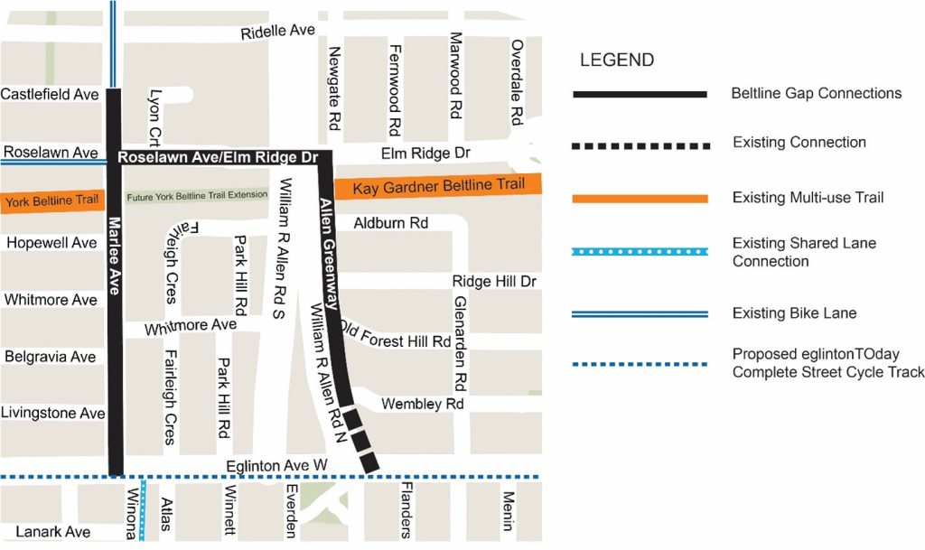
The project area is bounded by Marlee Avenue to the west, Eglinton Avenue West to the south, Castlefield Avenue, Roselawn Avenue and Elm Ridge Drive to the north and Newgate Road and the Allen Greenway to the east.
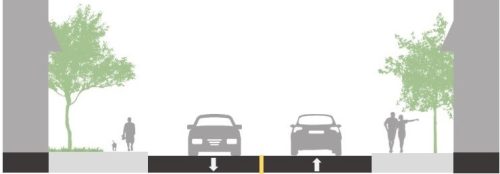
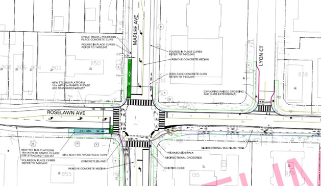
View the preliminary design drawings.
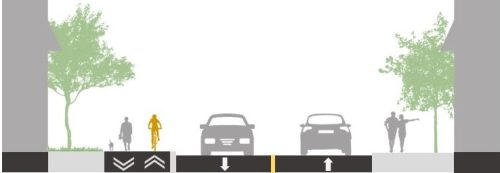
View the preliminary design drawings.
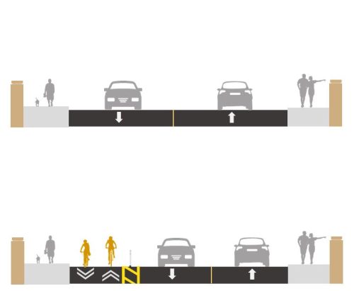
View the preliminary design drawings.
As part of the Cycling Network Plan – 2024 Cycling Infrastructure and Missing Sidewalk Installation – Third Quarter Update, City Council approved the installation of new bikeways associated with the Beltline Gap Connections Project (Eglinton-Lawrence ward) on June 26 to 28, 2024. View the staff report at IE14.4.
City Council also directed staff to further engage with impacted property owners on the west side of Marlee Avenue between the York Beltline Trail and Eglinton Avenue West to communicate changes and reduce private property encroachment impacts within the public right-of-way.
The engagement for this project is on pause due to Council’s direction (2025.MM30.13).
City Council has directed staff to pause the Beltline Gap Connection project and requested the Chief Planner and Executive Director, City Planning, in consultation with the Executive Director, Development Review, to consider the project as part of a more comprehensive transportation and mobility plan included in the Growing Glencairn Study (2025.MM30.13).
Project implementation has been placed on pause while the City of Toronto reviews the project’s impact on other active projects in the area.
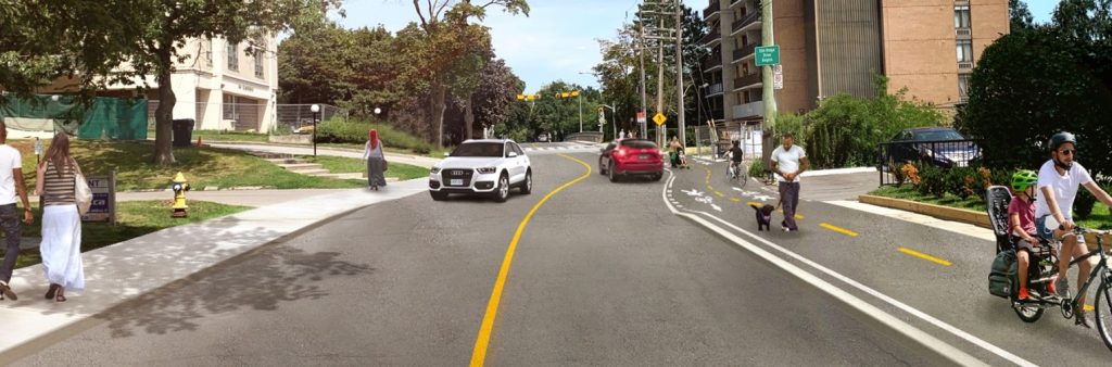
This project was approved by Toronto City Council on June 26, 2024 (IE.14.4). It is focused on closing the 475 metre gap between the York Beltline and Kay Gardner Trails and creating a continuous safe and comfortable cycling and pedestrian experience.
Further, state of good repair work in the area is programmed, presenting a once in a generation opportunity to make improvements. The state of good repair work includes: road reconstruction on Roselawn Avenue and Elm Ridge Drive in 2026 to 2027 (between Marlee Avenue and the western limit of the William R Allen Road Bridge) and on Marlee Avenue (between Hopewell Avenue and Roselawn Avenue).
In the past ten years, there have been 343 total collisions, including one pedestrian fatality in the project area. Bikeways and sidewalks are a critical piece of transportation infrastructure that improve accessibility and safety for all road users, particularly for children, seniors and those with mobility challenges.
This project supports the City’s Vision Zero Road Safety Plan with the goal to eliminate traffic-related fatalities and serious injuries by making our roads safer for everyone.
Cycling is the fastest growing mode of transportation in Toronto as an efficient option for daily travel, not just for recreation. As such it is important that the cycling network is intuitive and connected to essential destinations like shopping, work and transit stations.
As Toronto continues to grow it is important to provide efficient transportation options with many roadways already functioning at capacity.
See “Previously Approved Changes” tabs for further information on the design.
Engineering and Construction was working on the detailed design and sequencing of the road work for 2026-2027. The detailed design for this project is on pause due to Council’s direction (2025.MM30.13).
The Beltline Trail Extension Park, south of Roselawn Avenue and Elm Ridge Drive between Marlee Avenue and the Allen greenway (east side), is planned for construction in 2026, pending the completion of the Reena Housing Project. The feasibility of a year-round cycling connection to close the gap as part of the new park was considered, but unfortunately several factors prohibit this:
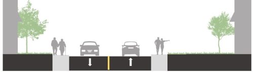
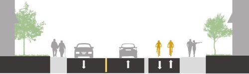
Lane widths have impacts on vehicle speeds, pedestrian crossing distances, on-street parking, transit routes, and accommodation for people who cycle. All these factors are considered when determining the appropriate width of lanes. The City of Toronto Lane Width Guidelines are designed to provide appropriate motor vehicle accommodation while improving safety for all road users, improving accommodation for people cycling, and making effective use of limited right-of-way and pavement widths.
Passenger car, truck and bus turning movements are modelled and reviewed by technical design review partners to make sure movements are accommodated.
Implementing lane widths that are not excessively wide encourages drivers to travel slower and not exceed the speed limit, resulting in reduced impact speed in the event of a collision and provides drivers with more reaction time.
All turn lanes in the project area were being kept, except for the westbound left–turn lane at Roselawn Avenue and Marlee Avenue due to space constraints.
In light of Bill 212, staff are also looking at a potential road widening to accommodate the westbound left-turn lane at Roselawn Avenue and Marlee Avenue:
The City is studying the area around Glencairn Subway Station to guide growth, align with provincial density requirements around transit stations, and provide for a resilient and inclusive complete community. The Beltline Gap Connections is being noted and considered as part of a the Growing Marlee-Glencairn Study.
The cycle tracks, multi-use trails and sidewalks will be maintained year-round by the City of Toronto, including for winter plowing and salting.
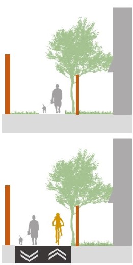
On Marlee Avenue, there will be snow storage space in the buffer area between the sidewalk and bi-directional cycle track, and between the vehicle lane and the bi-directional cycle track.
On Roselawn Avenue and Elm Ridge Drive, there will be snow storage in the buffer area between the multi-use trail and the bi-directional cycle track buffer and the roadway.
Snow storage will be possible on both sides of the Allen Greenway East.
Some private items on City property may be impacted. Whenever possible, the City mitigates impacts by adjusting the design. Once detailed design is advanced, residents and businesses affected by the changes on Marlee Avenue would be consulted before the work begins. Property owners would be invited to meet with City staff to discuss the design. Residents with private property encroachments on City property would receive a follow-up letter outlining the right-of–way impacts.
Some trees within the City’s right-of-way may be impacted on Marlee Avenue and the Allen Greenway. The City has engaged an arborist to explore the best options to minimize tree impacts. Once the detailed design has been advanced, the number of trees and types of impacts would be confirmed. Opportunities for green infrastructure with new plantings would be confirmed through the detailed design process. Some of the new curb extensions and cycle track buffers would be planted.
Existing bus stops would be consolidated to ensure efficient service though the TTC’s Request Stop Program would remain in effect. Changes to bus stops would be implemented through the project.
Monitoring
Once construction is finished, a project is not yet complete. It takes time for people to adjust to change. The City would continue to receive and analyze feedback on the project and make adjustments as necessary.