

The City has developed a Neighbourhood Streets Plan (NSP) for Flemingdon Park. The Streets Plan proposed changes related to three main areas of concern in the neighbourhood:
Public feedback, along with technical considerations and City policies and guidelines, informed staff recommendations that were considered by North York Community Council.
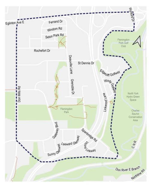
The Flemingdon Streets Plan project area is located between Eglinton Avenue East, Don Mills Road, the Don River and Overlea Boulevard.
Public and interest group opinions, along with technical and policy considerations, are used to inform City staff recommendations and decisions to be made by City Council. Public Consultation took place over two phases.
View the public event materials and Public Consultation Report summarizing all activities and feedback received:
View the public event materials and Public Consultation Report summarizing all activities and feedback received:
Public Consultation took place over two phases.
The Flemingdon Park neighbourhood was selected as one of five project areas for the Neighbourhood Streets Plan in the 2024-25 NSP program cycle. The neighbourhood was nominated for the NSP program by the local community. The primary concern identified at the nomination stage was the impact of excessive non-local traffic on neighbourhood mobility, specifically for those who commute by busses and cars. Details of the nomination process can be found on the Neighbourhood Streets Plan web page.
Background research also identified other previously raised community concerns about pedestrian safety, on-street parking, and transportation impacts related to new major infrastructure and development.
Several street planning and management projects are planned, underway, or have recently concluded in Flemingdon Park and surrounding areas. See the Related Information sidebar for more information. Flemingdon Park Streets Plan will align with existing approved plans and coordinate recommendations with planned future connections.
Neighbourhood Streets Plans (NSPs) service neighbourhoods where traffic and travel patterns challenge the safety and mobility of people using the streets. Through the NSP process, a team of City staff work with communities to identify local issues and opportunities, prioritize the greatest needs, and recommend changes to traffic operations and street designs. NSPs consider the needs of all road users and emphasize the safety of vulnerable road users such as seniors, school children, and people walking and cycling.
Each year dozens of nominations are received and five neighbourhoods are prioritized to participate in the program.
NSPs follow several steps outlined below, and public consultation takes place in two stages.
NSPs result in short-term actions which can be made using temporary, flexible materials like signs, asphalt, paint, and bollards, and identify longer term changes which can be accomplished alongside future planned road work.
The outcomes of each NSP are different based on local conditions and the needs of each neighbourhood. Generally, NSPs recommend actions related to motor vehicle speed and volume management, and traffic safety conflicts on local streets. NSP recommendations are informed by the City’s Traffic Calming Guide, Vision Zero Action Plan, and Complete Streets Guidelines.
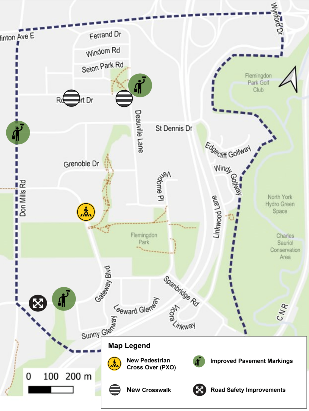
North York Community Council has approved the following changes to address road safety for vulnerable road users:
New Crosswalk
New or Improved Pavement Markings
Road Safety Improvement (changes to road design and geometry)
New Pedestrian Crossover: a new pedestrian crossover will be considered by North York Community Council, at:
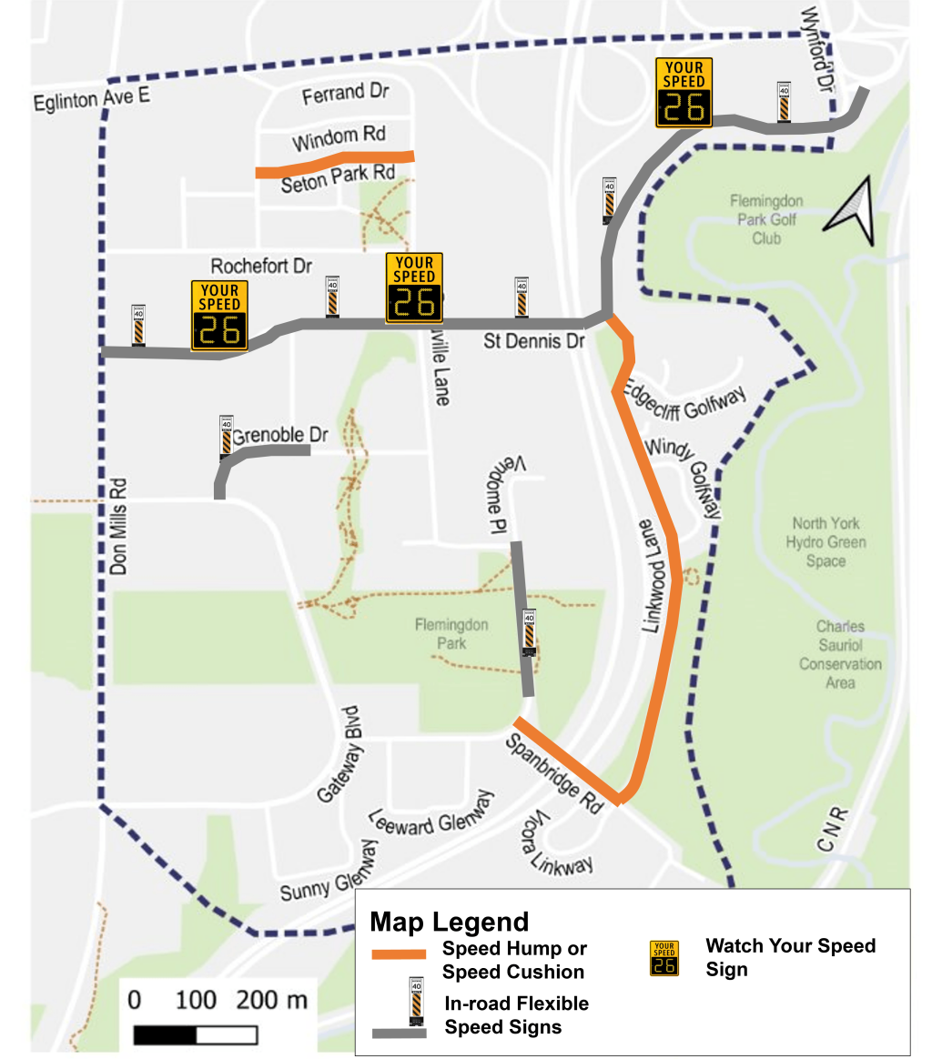
North York Community Council has approved the following changes to address excessive speeding:
Speed Cushions
Speed Limit Reduction
Other speed management measures to address excessive speeding include:
In-road flexible speed signs
‘Watch your speed’ sign
Residents have raised concerns about traffic volumes within the neighbourhood. Traffic volume data from the past five years shows that all streets in the neighbourhood, including those impacted by school traffic, remain below the City’s standard thresholds for vehicle volumes.
While no traffic volume management measures are proposed through this Streets Plan, signal timings are under review at key intersections and the proposed speed management measures may help discourage non-local traffic on local streets.
Signal Timing Modifications (Under Review)
Stay Informed
To receive project updates by email, please contact us and indicate that you would like to be added to the mailing list.
Personal information is collected under the authority of the City of Toronto Act, 2006. The information is used to allow the City to send you emails about project updates and future consultation opportunities. Questions about this collection may be directed to the Manager, Public Consultation at 416-392-2990 or tracy.manolakakis@toronto.ca