The Lawrence Park Transportation Plan does not revisit the Council-approved recommendations identified through the Lawrence Park Road & Stormwater Management Study process.
June 2025 : North York Community Council has adopted the Lawrence Park Transportation Plan recommendations.
In April 2025 North York Community Council directed staff to provide a community update prior to a vote on the item. The Lawrence Park Transportation Plan was considered by North York Community Council on June 4, 2025.
A virtual public meeting was held on May 1, 2025 to provide a community update on the plan and background studies.
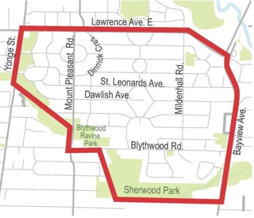
The Lawrence Park Transportation Plan boundaries are Lawrence Avenue East on the north, Bayview Avenue on the east, the Sherwood Park and Lawrence Park Ravine network to the south and Yonge Street on the west.
The LP Transportation Plan study area includes the Lawrence Park Neighbourhood Road & Stormwater Management study area, as well as other neighbourhood streets for which additional study was undertaken.
Traffic studies collect precise travel speed data from motor vehicles. Studies completed between 2021 and 2024 suggest that there are local roads in the neighbourhood where motor vehicle operating speeds exceed 38 km/h (8 km/h above the posted limit).
City Council has already approved changes as part of the Basement Flooding & Road Improvement Environmental Assessment which will support speed management and encourage compliance with 30km/h speed limits. Council-approved changes include road narrowing and chicanes on streets that will be reconstructed through the Basement Flooding Protection Program. Implementation would take place between 2027 and 2032.
As part of the Lawrence Park Transportation Plan, Community Council has authorized the installation of 45 speed humps at various locations where roads are not being reconstructed, or where there is community support:
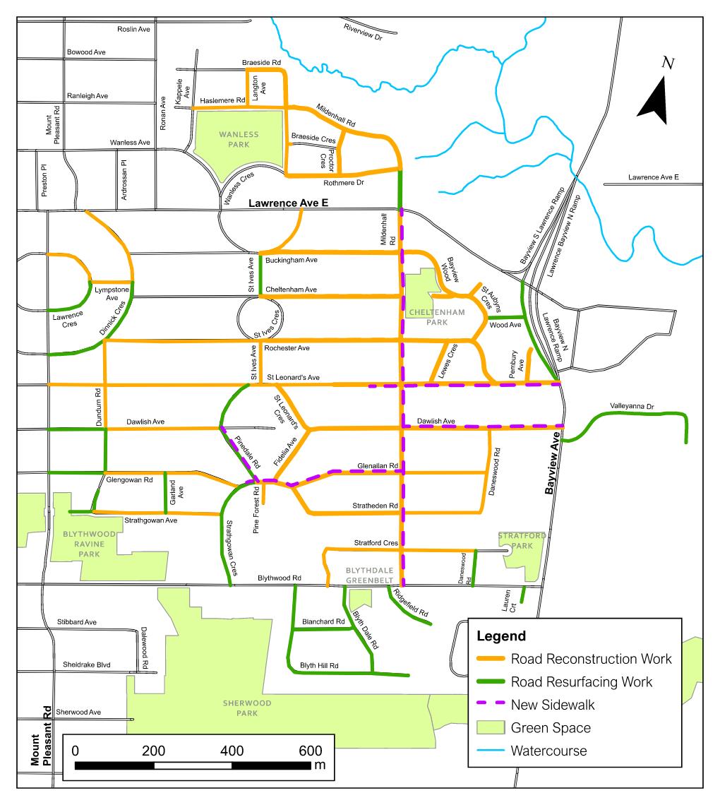
As part of the 2018 Lawrence Park Neighbourhood Road & Stormwater Management Study, City Council approved the installation of new sidewalks that will help to improve road safety in the area. Sidewalks were approved on one side of five streets: Mildenhall Road (east side), St. Leonards Avenue, Dawlish Avenue, Pinedale Road and Glenallen Road/Strathgowan Crescent. Installation will take place alongside planned road and stormwater design and reconstruction delivered through the Basement Flooding Protection Program.
Where feasible, road safety improvements will be implemented alongside planned road and stormwater design and reconstruction.
Intersection realignment modifies the layout of roads to improve safety. Modifications can include:
Raised crosswalks have a higher elevation that the adjacent roadway. Benefits include:
The Lawrence Park Public Consultation Report summarizes feedback received.
A virtual Public Meeting was held on June 25, 2024, that included a presentation and question & answer period. View the presentation and meeting summary below.
Next Steps
In 2018, the City finalized the Lawrence Park Basement Flooding & Road Improvements Study, which made recommendations to address deteriorating road conditions, traffic and pedestrian safety, road drainage problems and basement flooding in the area.
The recommendations, which were approved by City Council in 2017 will be delivered through the Basement Flooding Protection Program.
Planned work includes:
Council-approved changes will not be revisited as part of the Transportation Plan.
In 2019, following the completion of the EA study, North York Community Council requested Transportation Services to develop a traffic management plan to address additional concerns raised by the community for implementation in coordination with the Basement Flooding Protection Program.
City staff have used a data-driven approach to understand existing conditions in Lawrence Park and develop potential changes.
Traffic data measuring vehicle volumes, speeds and turning movement counts:
Collision data collected by Toronto Police Services indicating the number of collisions resulting in death or serious injury:
Concerns and requests from the public and local Councillor:
Site visits and observations in the neighbourhood.
Lawrence Park Transportation Plan recommendations are informed by the City’s Traffic Calming Policy, Vision Zero Road Safety Plan and Complete Streets Guidelines, and focus on speed management and road safety for all users.
The LP Transportation Plan considers changes that can be made to improve road safety and speed management. Vehicle volumes in Lawrence Park were within the working maximum capacity for local and collector roads, based on the City’s Road Classification System; no vehicle volume management measures are proposed.
The LP Transportation Plan involved several steps:
Step 1: Review feedback on local issues.
Step 2: Develop a plan to address issues.
Step 3: Consult the public on potential changes.
Step 4: Finalize LP Transportation Plan for approval by Community Council.
The final step is Step 5: Implement approved LP Transportation Plan changes.
To receive project emails, please email LawrencePark@toronto.ca to be added to the email list.