In July 2023, the City of Toronto initiated preliminary work to prepare for the road reconstruction and replacement of the City-owned portion of substandard water service connections on Port Union Road from Island Road to Lawrence Avenue East. Improvements being made as part of this work include widening Port Union Road to create a new northbound vehicle lane, installation of raised cycle tracks and continuous sidewalks on both sides of the street. Full road reconstruction started in spring 2024.
To improve road safety, new centre-lanes will be placed at select locations, and curb extensions with raised pedestrian crossings will be added at side streets. Once complete, these changes will improve conditions for people walking, cycling and driving, and will help to better manage traffic flow.
The Port Union Road Improvements Project from Island Road to Lawrence Avenue East is now substantially complete, and all travel lanes are now open to the public.
All road construction, including the raised cycle track, has been completed. The cycle track is anticipated to open in early 2026.
The following final restoration works are scheduled for Spring 2026:
All remaining work will be completed using localized lane closures, with minimal travel impacts.
Starting October 14, the City’s contractor will begin the final paving work on Port Union Road, between Island Road and Lawrence Avenue East. Work crews will grind the existing pavement and perform road base repairs, where necessary, and complete the final top layer asphalt paving.
See the Overnight Notice for more details.
Starting in early April, the City’s contractor will begin road reconstruction on the east side of Port Union Road, between Island Road and Lawrence Avenue East. During this phase of construction, traffic lanes will be adjusted to maintain one lane of traffic in each direction.
Pedestrian access will be maintained at all times.
Construction on the west side of Port Union Road, between Island Road and Lawrence Avenue East is now complete.
Winter work on the east side of Port Union Road
The following work has been identified as the most suitable to carry out during the winter months to ensure steady progress on the project. All activities are weather-dependent and may need to pause during periods of extreme cold or heavy snowfall. Planned work includes:
Snow clearing will be managed by both the contractor and the City’s winter operations team. There will be a winter break from December 20, 2024, to January 5, 2025.
The City of Toronto began road reconstruction on Port Union Road from Island Road to Lawrence Avenue East in July 2023 and was anticipated to be completed in December 2024. However, due to conflicts with several existing underground utilities, including Bell, Hydro, and Rogers, construction work was delayed while the City’s contractor addressed and resolved these known conflicts.
The City now expects all road work on the west side of Port Union Road from Island Road to Lawrence Avenue East to be completed by mid-December 2024. To advance the road work, the contractor will be looking to work over the winter months (weather permitting). The contractor will then start work on the east side of Port Union Road in Spring 2025.
The overall project is now projected to be completed by late 2025.
See the Construction Update #3 for more details.
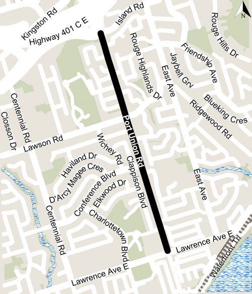
The construction area, illustrated below, is Port Union Road from Lawrence Avenue East to Island Road.
Curb extensions and raised crossings installed at various locations across the City as part of the City’s Vision Zero Safety Plan. These types of features help reduce conflicts between pedestrians, people cycling and people driving, and area designed to:
Curb extensions installed at the following intersections of Port Union Road:
For further details on the improvements, please see November 2021 Public Information presentation and the roll plan for property specific details.
The project is expected to take from July 2023 to late 2025.
Work can take place from 7 a.m. to 7 p.m., Monday to Friday, with work after hours and on weekends as required.
The contractor is responsible to minimize construction related noise. Higher levels of noise can be anticipated during concrete breaking work.
The contractor is responsible for minimizing dust in the work zone.
The City has been working with businesses and property management representatives to accommodate delivery and loading activities during construction. If you have not yet discussed your delivery needs with the project team, please contact the staff person listed on this web page as soon as possible.
The City’s contractor must ensure safe and accessible walkways and entryways are maintained for everyone during construction. Any temporary access disruptions will be communicated as soon as possible. If you experience a disruption, have a specific access need or related accommodation request, contact the person listed on this web page.
If travelling in the area, please be aware:
Turning lanes and the additional travel lane will be impacted when work occurs within close proximity to these lanes. These impacts will be temporary and the lanes will reopen once the work is complete.
TTC Service Impacts
The Environmental Assessment (EA) for this project was approved in 2004. A subsequent EA Addendum (update) was completed in 2014, approved in 2015 and made changes to the original study design in order to reduce property and community impacts.
This Environmental Assessment Study identified a preferred design which included:
The Addendum (update) to the 2004 ESR was approved by the Ministry of Environment and Climate Change (MOECC) in August 2015.
In consultation with the community as directed by City Council in 2004, the preferred design was modified to reduce property and other impacts to the community, and to meet current City standards and practices. The updated preferred design provides the same level of service as the original design, but includes the following changes:
To view the Environmental Assessment Addendum Report, contact Nathalie Forde at 416-392-3556 or Nathalie.Forde@toronto.ca.
The City conducted field investigations including a survey of the area and analysis of soil samples in various locations along Port Union Road to confirm ground conditions. Based on the results, the City is developing the project design.
The City completed the detailed design, utility relocations and secured easements. In the summer of 2021, the detailed design was updated to accommodate additional safety improvements including a raised cycle track, curb extensions with reduced corner radii, setback raised pedestrian crossings and speed limit reduction to 50km per hour.
In addition, several improvements are included in the design for the project that have the potential to reduce traffic speeds and infiltration into residential areas, including Tilley Drive, and improve visibility of pedestrians and cyclists. These improvements include:
A Virtual Project Update Meeting was held on November 30, 2021. Please see Port Union Road Virtual Public Information Event presentation and the Port Union Road roll plan for property specific details.
Sign-up to receive construction updates by email.