Recreation at Biidaasige Park
Biidaasige Park has unique amenities to explore for all ages.
There are two dogs off-leash areas, and each has:
- seating
- K-9 rated artificial turf
- accessible pathways and gates
- water fountains
- waste bins
Since Biidaasige Park is a new park, the asphalt is fresh, and paw protection is recommended for dogs.
One off-leash area is 800 square metres and is west of Cableway Canyon (Adventure Playground). Get to the off-leash area directly from Commissioners Street or the main path of Biidaasige Park.
One off-leash area is 1,200 square metres and is located east of Old Fire Hall 30. Get to the off-leash area directly from Commissioners Street or the east side of the Old Fire Hall 30 Plaza.
Other Areas in the Park
Off-leash dogs are not allowed in the park. This is to protect the sensitive ecological integrity of the Floodplains and the planted areas of the Uplands. Learn more about Responsible Dog Ownership.
Fishing
There are a dozen places to fish in the renaturalized Don River and its wetland habitats. These fishing locations have signs.
Fishing in Biidaasige Park requires a valid Outdoors Card and a fishing license tag.
Paddling
Paddle boats include:
- canoes
- kayaks
- stand-up paddleboards
Access Points
While we aim to provide fully accessible content, there is no text alternative available for some of the content on this site. If you require alternate formats or need assistance understanding our maps, drawings, or any other content, please contact BiidaasigePark@Toronto.ca.
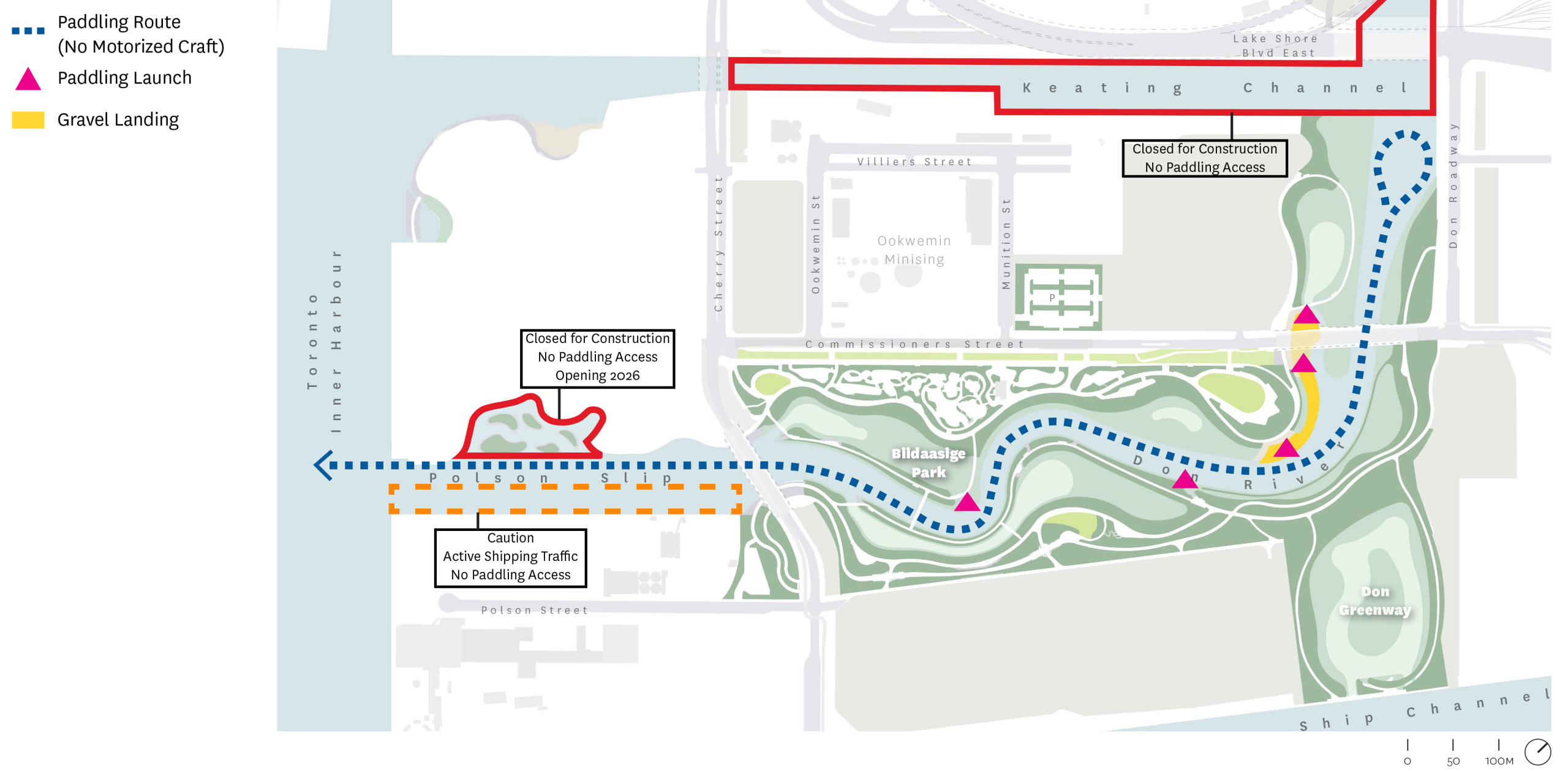
In the future, there will be multiple locations across Biidaasige Park’s Floodplain where visitors can access the water.
Polson Slip: New Mouth of the Don River
Located near the west end of the Don River where it opens into the Inner Harbour, Polson Slip is the main access point to Biidaasige Park.
Motorized watercraft are prohibited in the Don River east of the Cherry Street South Bridge and Keating Channel, making it ideal for paddlers.
River Bend Landing
River Bend Landing is a cobblestone landing with steps leading to the nearby BBQs and River View Picnic Terrace, south of Snowy Owl Playground. It is designed for paddle craft boat access.
There is also an unnamed landing on the river’s north side connected to a footpath that leads north to Snowy Owl Playground and Old Fire Hall 30.
Navigation
Within the Don River, you can paddle:
- north to the Keating Channel
- south/west to Polson Slip and the Inner Harbour
Inside the Polson Slip west of the Cherry Street South Bridge, stay close to the north shore to avoid freighter traffic from the Lafarge cement operation.
Avoid entering the Slip if freighters are moving in or out.
Closures
The Keating Channel and the Lower Don River north of the Keating Channel are currently closed to paddlers due to ongoing construction. Canoe Cove in Biidaasige Park West is also closed and expected to open in 2026.
Storage
There is no canoe or kayak storage on-site.
Paddle Boat Safety
Lifesaving equipment is installed across the Floodplain to ensure visitors, emergency services personnel and park staff can help in case of a water-based emergency.
Old Fire Hall 30 is a small community building staffed and programmed by the City of Toronto. The building was constructed in 1920 and operated as Fire Hall 30 until 1980. The historic building was preserved and moved to its present location to provide recreation activities for all ages.
Learn more about Old Fire Hall 30 and planned activities.
All sections of the park are connected by trail or bridge.
Atlas Crane
Atlas Crane will be completed in 2026.
Located west of the Cherry Street South Bridge, the Atlas Crane is one of the last remaining heavy-duty cranes of its time. Installed in 1961, it was used for loading and unloading cargo to Marine Terminal 35, including old Toronto Transit Commission (TTC) streetcars. It was decommissioned as part of the Port Lands Flood Protection initiative.
The Atlas Crane is a designated heritage structure. It has cladding around its base and is painted with anti-climbing paint to discourage visitors from climbing it.
The Atlas Crane will be lit at night to be a wayfinding element and to highlight its industrial design.
Indigenous Plantings
In collaboration with Indigenous communities, plants were chosen to reflect the native ecology of the ecosystem and to represent plants that have medicinal and cultural significance for Indigenous communities. Species include:
- Sacred Tobacco
- White Sagebrush
- Staghorn Sumac
- Black Cherry
- Sweet Grass
- St. John’s Wort
- and more
These plants are highlighted in interpretive signage.
Marker Trees
Marker trees are carefully grown with a right-angle bend to point the way to trails, crossing points on streams and otherwise highlight areas of significance.
Marker trees will be grown over the years in partnership with Nikibii Dawadina Giigwag (NDG) and the Daniels Faculty of Architecture, Landscape and Design at the University of Toronto.
Self-Guided Tours
Interpretive signage will be available in 2026.
Interpretive signage highlights the Port Lands’ history, the park’s construction, its unique physical, cultural and environmental features, and its Indigenous significance.
Viewpoints
Outlooks and viewing points have been installed throughout the park and offer views of the:
- Inner Harbour and Toronto Island Park
- renaturalized Don River
- Toronto skyline
- Lower Donlands
- Port Lands extending out to Cherry Beach Clarke Beach Park and Tommy Thompson Park
Water’s Edge Promenade
Water’s Edge Promenade will be available in 2026.
At the western edge of Biidaasige Park, where Ookwemin Minising ends, a waterside promenade has been constructed on the former site of Marine Terminal 35. This promenade has a view of the Inner Harbour, the Toronto Islands and the Toronto skyline, and is part of the Biidaasige Park trail and path system.
No swimming or diving off the dock wall is allowed for health and safety reasons.
Fitness equipment is available west of Cableway Canyon.
The new play areas at Biidaasige Park offer some of Toronto’s most exciting places for play and creativity.
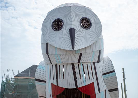
Snowy Owl Theatre
The snowy owl has a stage built into its belly where kids can perform for fun or play with sound features, like a drum or bells. There is a talk tube that lets kids talk to one another from one area of the stage to another.
The seating around the Snowy Owl is made to look like a nest.
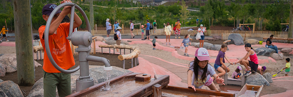
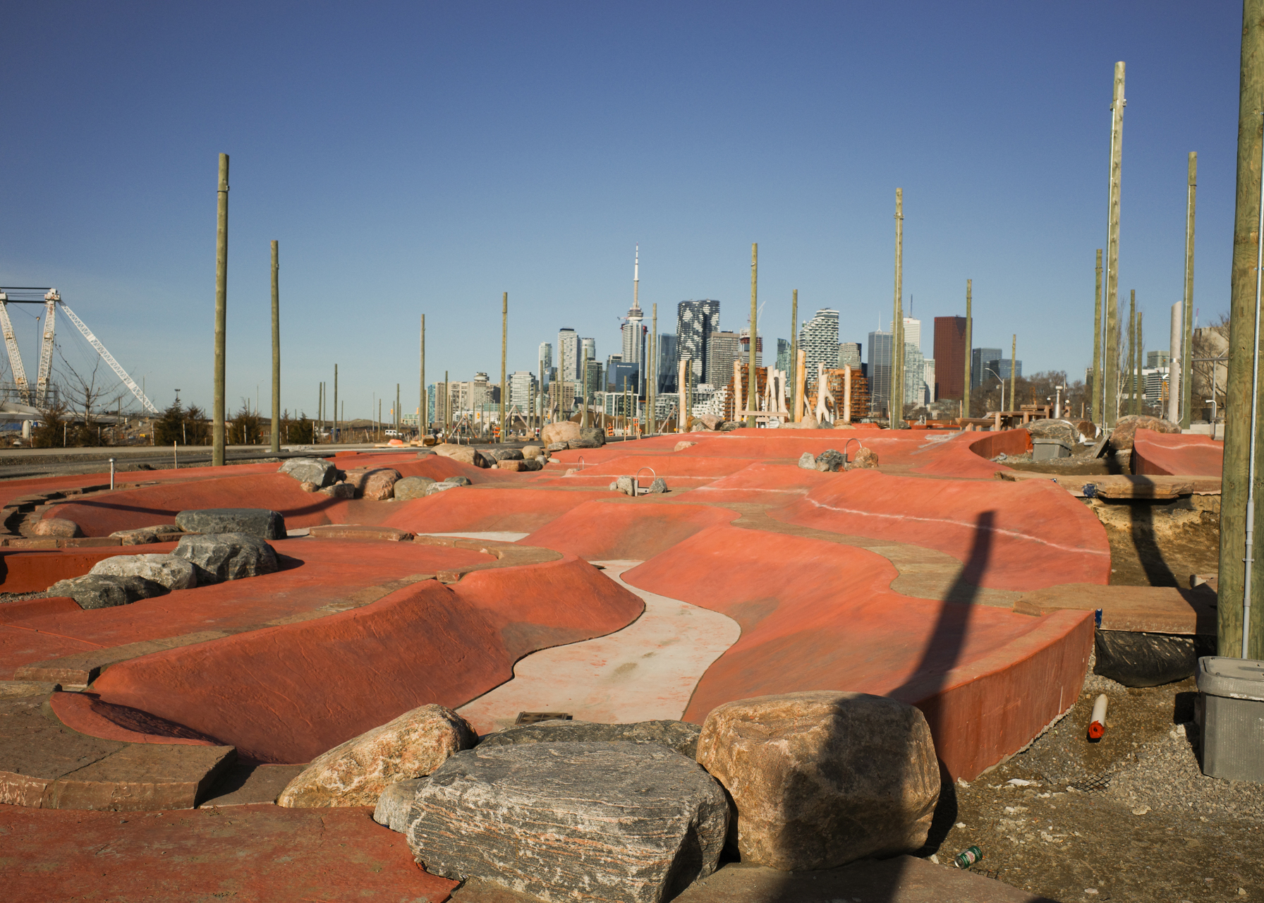
Badlands Scramble
Inspired by Ontario’s Cheltenham Badlands, Badlands Scramble is 1600 square metres and has three wavy levels with flat sections of stone pavement.
It includes a water feature that invites kids to work together to pump water down its winding slopes.
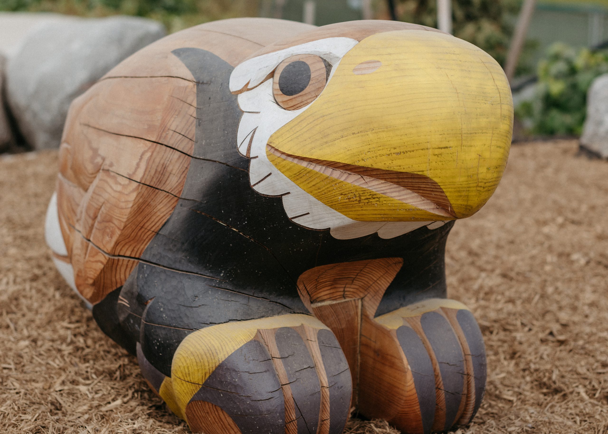
Dodem Animal Sculptures
Dodems are animals that represent a clan or family line in the Anishinaabe, Ongwehonwe and Huron cultures. Each animal is associated with clan characteristics and important community teachings. These carved play features incorporate Indigenous stories and culture.
You’ll find a bear, beaver, eagle, turtle, otter, wolf and musky fish.
Cableway Canyon
Cableway Canyon has 20-metre and 40-metre cableways.
Other Play Features
- Swings on Swing Hill
- Mock beaver dam play area