Artistic rendering of Havelock Street and Bloor Street intersection.
The City of Toronto has installed bikeways and other road safety improvements on Bartlett Avenue, Havelock Street, and Gladstone Avenue from Davenport Road to College Street, as well as associated changes to short sections of Bloor Street and Lindsey Avenue as part of phase 1 of the Bartlett-Havelock-Gladstone Cycling Connections Project. Phase 1 was approved by City Council on April 7, 2022. A copy of the staff report is available at IE 28.7.
Phase 2 of the project was installed in 2023, and included new contra-flow bike lanes, traffic signals, and changes to the direction of motor vehicle travel on Gladstone Avenue between College Street and Peel Avenue, as well as a new traffic signal on Dufferin Street at Peel Avenue (north of Queen Street West). Phase 2 was approved by City Council on June 14, 2023. A copy of the staff report is available at IE4.3.
Project Goals:
Improve safety for people walking, cycling and driving.
Encourage cycling by connecting and improving bikeways, and creating an alternative to north-south travel on Dufferin Street.
Reduce neighbourhood traffic infiltration, and maintain local access for residents and City services.
Minimize impact to on-street parking.
The 3.5 km bikeway project will improve safety by lowering motor vehicle travel speed, prioritizing people walking and cycling, and reducing local traffic infiltration.
City services, including fire, emergency medical services, waste pick-up, and snow clearing, will continue as usual. There will be no impact to existing sidewalks or speed limits and all local motor vehicle access will be maintained.
Project Area
Phases 1 and 2 of the project have been installed.
Modifications to Phase 1: Gladstone Avenue and Havelock Street from Bloor Street West to College Street; segments of Lindsey Avenue and Sylvan Avenue.
2025 Updates
The City of Toronto has completed bikeway streetscape improvements on Gladstone Avenue near Lindsey Avenue.
Northeast of the Gladstone Avenue and Lindsey Avenue intersection, the City removed bays of concrete next to the roadway that are no longer used as a driveway, and planted a tree, grass and shrubs.
Southwest of the Gladstone and Lindsey intersection, a gap in the curb was filled in and a new tree was planted.
Staff coordinated with the Councillor’s office on these improvements. Please see the Construction Notice for more details.
2023 Modifications
After installing phase 1 and collecting community feedback and monitoring data, the following modifications were proposed on Gladstone Avenue and Havelock Street from Bloor Street West to College Street as well as segments of Lindsey Avenue and Sylvan Avenue. After collecting community feedback, the modifications are planned to be installed in 2023.
Parking:
Reinstate approximately three on-street parking spaces on Gladstone Avenue north of College Street that were made into a “No Standing” zone.
Add approximately six new parking spaces on the north side of Sylvan Avenue next to Dufferin Grove Park between Dufferin Street and Gladstone Avenue.
Local greening opportunities:
Plant two new trees on Gladstone Avenue near Lindsey Avenue (one on each side of Lindsey Avenue).
Continue to support local volunteers to water, to maintain planters, and to replant if needed. Interested community members are invited to join the existing volunteers.
Planning for a resurfacing of Havelock Street:
Include improvements on Havelock Street as part of the 2025 road resurfacing program, including:
Installing new asphalt for all road users;
Adding and/or improving pedestrian crossings;
Adding accessibility features at intersections; and
Replacing above-ground, plastic planters with in-ground planting beds.
Traffic diversions:
Replace temporary traffic diversion signs with permanent signs.
No changes are being proposed for the traffic diversions, including the cycling-only block on Havelock Street between Dewson Street and Sylvan Avenue and the diagonal diverter at the intersection of Lindsey Avenue and Gladstone Avenue.
Phase 2 Design Details: College Street to Dundas Street West
In this section, the following improvements were made on Gladstone Avenue:
Traffic calming measures were added mid-block where parking is not permitted.
Shared lane markings and signage were added to alert road users.
A southbound-through restriction was introduced from 3:30 to 6:30 p.m., Monday to Friday, at Dundas Street West to reduce traffic infiltration on this block and the block south of Dundas Street West.
Two-way vehicle access and on-street parking was maintained.
People cycling in both directions on Gladstone Avenue between College Street and Dundas Street West.An example of a contra-flow bicycle lane where people cycling can travel in both directions on a street, which is one-way for all other vehicles.
Phase 2 Design Details: Dundas Street West to Peel Avenue
Two options were considered for this segment. Option 1 was selected and was installed in late summer 2023. Vehicle volume thresholds in this segment are still above City standard for safe contra-flow bikeways; therefore, changes to traffic operations may be revisited in the future.
Item
Option 1 –Contra-flow Bikeway (Installed in 2023)
Option 2 – Neighbourhood Greenway (not selected)
Cycling
Add a contra-flow bike lane to the east side of Gladstone Avenue to accommodate cycling in both directions; between Cross Street and Waterloo Avenue, the contra-flow bike lane would be next to parked cars.
Add a contra-flow bike lane on the opposite side of parking to accommodate cycling in both directions
Traffic infiltration and access*
Maintain all vehicle movements; no changes are proposed to reduce non-local vehicle traffic
Reduce traffic infiltration on Gladstone Avenue and Argyle Street, and increase safety for pedestrians and people cycling by:
Requiring southbound traffic to turn at Collahie Street and Argyle Street
Converting the block between Stonehouse Crescent and Collahie Street into a one-way northbound, and making parking permanent on the east side
Installing a cycling-only block between Argyle Street and Alma Avenue
Converting the block of Argyle Street from Gladstone Avenue to Antonio Lopes Lane into a one-way eastbound
Pedestrian crossings
Add crosswalks at Cross Street and Alma Avenue
Add crosswalks at Cross Street, Argyle Street and Alma Avenue
Parking
Make parking permanent the west side of Gladstone Avenue, except between Cross Street and Waterloo Avenue where it would be made permanent on the east side
Make parking permanent on one side of the street:
Parking would be made permanent on the west side between Dundas Street West and Collahie Street; and between Stonehouse Crescent and Alma Avenue.
Parking would be made permanent on the east side between Collahie Street and Stonehouse Crescent; and between Alma Avenue and Peel Avenue
Parking would be made permanent on the north side on Waterloo Avenue
No parking spaces would be removed
Remove approximately 15 parking spaces to enhance safety, maintain school bus loading zones and accommodate truck turns.
*Both options maintain vehicle access to all properties, loading docks, and school loading, pick-up and drop-off areas; and maintain emergency services and solid waste collection.
Phase 2 Design Details: Dufferin Street Traffic Signal at Alma Avenue or Peel Avenue
Two options were considered for a new traffic signal along Dufferin Street to create a safe crossing for pedestrians and people cycling. Option 2 was selected because it provides easier access to Pessoa Park, the West Toronto Railpath and the Peel Avenue bikeway. In addition, it was the option that was preferred during public consultation.
This signal is being designed and is planned for construction in coordination with the West Toronto Railpath Extension.
Option 1 – Alma Avenue (not selected)
Option 2 – Peel Avenue (planned for construction)
Location
Add a traffic signal to the intersection of Dufferin Street and Alma Avenue
Add a traffic signal to the intersection of Dufferin Street and Peel Avenue
Transit
Maintain the existing TTC Dufferin 29 bus stop
Move the TTC Dufferin 29 bus stop from Alma Avenue to Peel Avenue
Parking
Remove approximately 12 parking spaces on both Dufferin Street and Alma Avenue to improve intersection safety and visibility
Remove approximately 17 parking spaces on both Dufferin Street and Peel Avenue to improve intersection safety and visibility
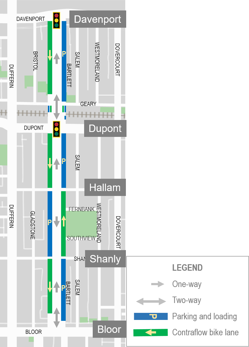
Phase 1 Design Details: Bartlett Avenue from Davenport Road to Bloor Street
Bartlett Avenue from Davenport Road to Bloor Street
If you drive:
New traffic signals added at Davenport Road and at Dupont Street.
No change to travel directions.
Restricted movements, including:
No northbound right-turns on red at Davenport Road.
No northbound straight-through, no peak period eastbound left-turns, and no right-turns on red at Dupont Street.
No westbound right-turns during peak periods from Bloor Street to Bartlett Avenue.
If you park or load on the street:
Parking permit hours remain unchanged.
Some impacts to on-street parking:
Nine parking spaces removed on Davenport Road and Bartlett Avenue to accommodate the new traffic signal.
East side parking made permanent between: Davenport Road and Geary Avenue; Dupont Street and Hallam Street; and Shanly Street and Bloor Street.
West side parking made permanent between Hallam Street and Shanly Street.
Seven of ten parking spaces maintained between Geary Avenue and Dupont Street.
Three 1-hour and three 3-hour parking spaces removed at Dupont Street.
Pick-up and drop-off at local schools maintained:
Dovercourt Public School: continues on Gladstone Avenue, Hallam Street, and the east side of Bartlett Avenue.
St Anthony Catholic School: 10-minute parking added to west side between Southview Avenue and Shanly Street during pick-up/drop-off hours.
Curbside space at Bloor Street maintained for commercial loading.
If you cycle:
Contra-flow bike lanes added between Davenport Road and Geary Avenue; and Dupont Street and Bloor Street to allow people cycling to travel north and south where vehicle flow is one-way.
Bike lanes added between Geary Avenue and CP Rail Tracks.
Shared-lane markings added between CP Rail Tracks and Dupont Street.
New bike signals added at Davenport Road and Dupont Street.
New Bike Share stations added at Davenport Road and Dupont Street.
If you walk:
Traffic signal added at Davenport Road replacing the pedestrian crossing at Salem Avenue and Davenport Avenue.
Pedestrian crossing converted to a traffic signal at Dupont Street.
If you take transit:
TTC 127 Davenport bus stops moved from Salem Avenue to Bartlett Avenue.
TTC 26 Dupont bus stops maintained and shifted closer to Bartlett Avenue.
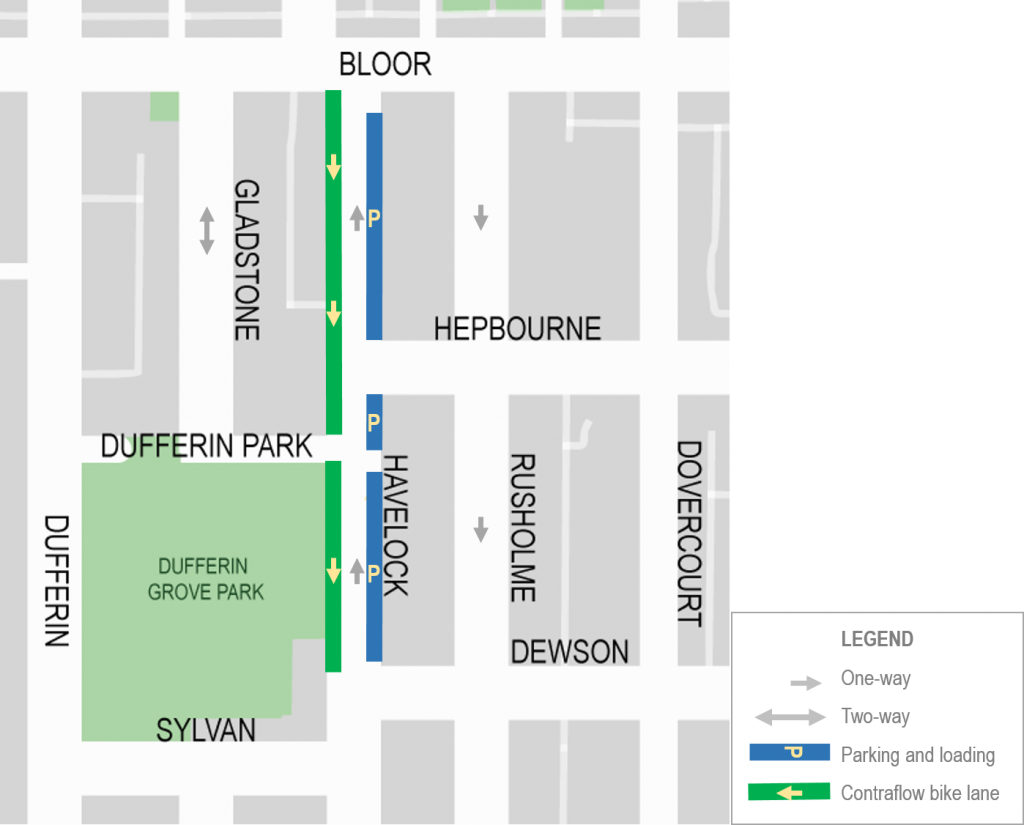
Phase 1 Design Details: Bloor Street from Bartlett Avenue to Havelock Street
Bloor Street from Bartlett Avenue to Havelock Street
If you walk or cycle:
Two-way bikeway added on the north side of Bloor Street between Bartlett Avenue and Havelock Street.
Bicycle traffic signal added to Havelock Street, and space for people cycling to wait when turning.
Pedestrian crossings maintained or improved.
If you drive or park on the street:
Restricted movements, including:
No westbound right-turns during the peak periods from Bloor Street to Bartlett Avenue.
Traffic signal maintained at Havelock Street and stop sign maintained at Bartlett Avenue.
Three Green P parking spaces removed on Bloor Street.
If you take transit:
TTC 300 Bloor night bus stops maintained with the westbound stop shifted closer to Salem Avenue.
Phase 1 Design Details: Havelock Street from Bloor Street to Dewson Street
Havelock Street from Bloor Street to Dewson Street
If you drive:
No changes to travel directions.
Northbound right- and left-turn lanes would merge into a single lane.
No northbound right-turn on red at Bloor Street.
If you park or load on the street:
East side parking made permanent between Bloor Street and Dewson Street.
Curbside “No Parking” near Bloor Street maintained for commercial loading and delivery.
If you cycle:
Contra-flow bike lanes added on the west side to allow people cycling to travel south.
Northbound cycling in a shared lane with vehicles.
New bike signals added at the Bloor Street intersection.
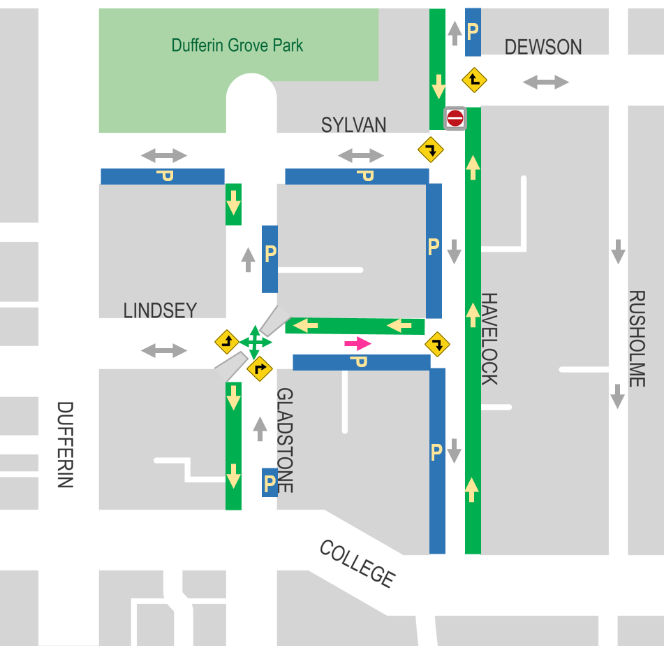
Phase 1 Design Details: Dewson Street to College Street
Read more about the changes between Dewson Street and College Street in the informational booklet.
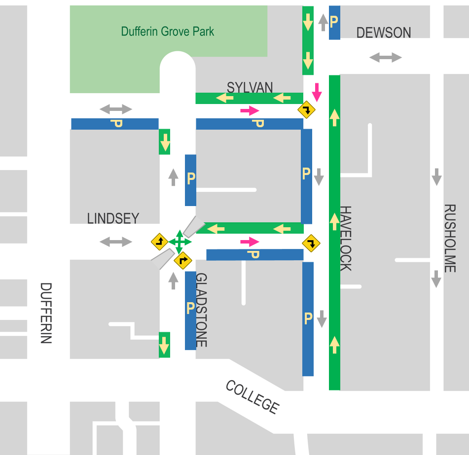
Havelock Street from Dewson Street to College Street; Lindsey Avenue and Sylvan Avenue from Havelock Street to Gladstone Avenue; and Gladstone Avenue from Lindsey Avenue to College Street
Through consultation activities, it was determined that Option 1 was preferred; however, the feedback collected also highlighted issues around parking availability. Read the Consultation Report to learn more
Option 1 is the final design chosen for this section though parking space loss was minimized compared with the original proposal.
The following information was presented during the consultation period.
Proposed changes common to both Options 1 and 2
Proposed design at Lindsey Avenue and Gladstone Avenue: people cycling can travel in all directions; people driving on Gladstone Avenue turn right; and people driving on Lindsey Avenue turn left. See both diagrams below
If you drive or park on the street:
Lindsey Avenue between Gladstone Avenue and Havelock Street converted to one-way eastbound.
A diagonal diverter added to the intersection of Lindsey Avenue and Gladstone Avenue.
Up to two parking spaces removed on both Gladstone Avenue and Lindsey Avenue to maintain vehicle space for delivery vehicles and waste pick-up.
Three parking spaces removed on Gladstone Avenue at Sylvan Avenue to improve road safety and visibility.
South side parking (including accessible parking) made permanent on Lindsey Avenue between Gladstone Avenue and Havelock Street.
If you cycle:
Contra-flow bike lanes added to Lindsey Avenue between Gladstone Avenue and Havelock Street and on Gladstone Avenue from Sylvan Avenue and 10m south.
Cycling allowed in both directions on Gladstone Avenue.
Option 1 (preferred):
If you drive:
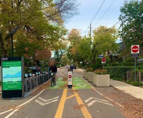
A cycling-only block on Havelock Street between Dewson Street and Sylvan Avenue.
All local motor vehicle access maintained.
Above: Existing cycling-only block on Shaw Street.
If you park:
Seven parking spaces removed on Gladstone Avenue between Lindsey Avenue and College Street.
If you cycle:
Cycling-only block could provide space for a Bike Share station, seating or greening opportunities.
Option 2:
If you drive:
Havelock Street between Dewson Street and Sylvan Avenue made one-way southbound.
Sylvan Avenue between Gladstone Avenue and Havelock Street made one-way eastbound.
If you park:
All parking spaces retained on Gladstone Avenue between Lindsey Avenue and College Street
If you cycle:
Contra-flow bike lane added to Sylvan Avenue between Gladstone Avenue and Havelock Street would allow cycling in both directions.
Public Consultation
Public Consultation took place from January 2022 to April 2023 in two phases to introduce the project to the community and identify overall needs and priorities. The consultation reports linked below provide a detailed summary of all activities that took place and feedback received through each.