City Planning and a team of consultants led by EVOQ Architecture, have been working on developing a HCD Plan for Baby Point. The project team is currently working towards a draft plan with objectives, policies and guidelines that aims to conserve heritage resources that contribute to its character and its cultural heritage value.
Draft for consultation purposes only, subject to further change and review.Note: words in italics indicates terms that will be defined in the HCD plan appendix.
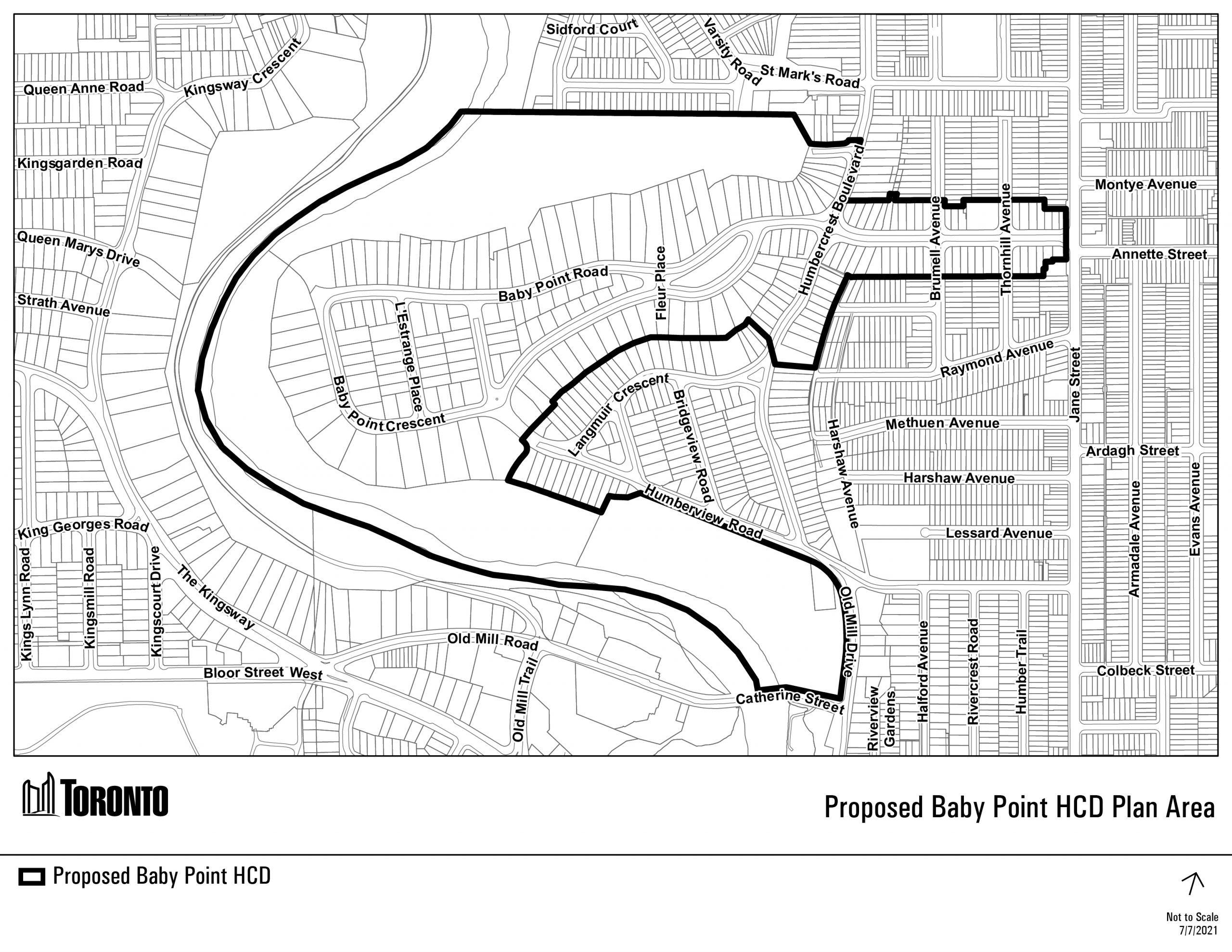
The District is a 34-hectare crescent-shaped area in the west end of Toronto and is bordered by the Warren Park neighbourhood to the north, Jane Street to the east, the Old Millside neighbourhood to the south, and the Humber River to the west. The District is comprised of a large promontory of land with steep forested slopes that extend into the Humber River valley. The District’s streets are laid out as a curvilinear network that includes Baby Point Road, Baby Point Crescent, L’Estrange Place, Baby Point Terrace, the west side of Humbercrest Boulevard from Langmuir Gardens to Baby Point Road, and both sides of Humbercrest Boulevard from south of Baby Point Road to Langmuir Gardens. The District was the location of Teiaiagon, the mid-to-late seventeenth century Haudenosaunee village. The District contains 220 properties, Etienne Brule Park, Magwood Park, and part of Cashman Park. The entrance to the District from Jane Street is marked by the Baby Point Gates. The District is part of the City of Toronto’s Teiaiagon Archaeologically Sensitive Area (ASA).
The District has cultural heritage value based on thousands of years of Indigenous settlement and use, archaeological resources and burials, natural features, and association with Indigenous ways of knowing and being. The District is also a designed cultural heritage landscape, based on its landscape features, street pattern, and built form which reflect the Garden Suburb design.
The District has historic and associative value as part of the ancestral lands of the Mississaugas of the Credit, the Haudenosaunee, and the Wendat peoples, and as the location of Teiaiagon, a mid-to-late seventeenth century Haudenosaunee village. The District is associated with and is part of the Toronto Carrying Place Trail, a system of Indigenous trails that linked Lake Ontario with Lake Simcoe.
The District is associated with ancestors of the Huron-Wendat Nation who used the Carrying Place Trail for travel, harvesting, hunting, gathering, and trade until the early-to-mid 1600s. The District is associated with the Seneca Nation, one of the members of the Haudenosaunee Confederacy; their village, Teiaiagon, was once home to 500 to 800 people. From their location on the District’s promontory, the Seneca Nation managed trade along the Humber River. Part of a matrilineal, agricultural society, the village cultivated fields of corn, squash, and beans, harvested fish, plants, waterfowl and animals in the abundant lower reaches of the Humber River, engaged in ceremonies and commerce with other communities. The District is also associated with the Mississaugas of the Credit First Nation, who used the Carrying Place Trail and the Humber River and established villages in the immediate area. The Huron-Wendat Nation, the Six Nations of the Grand River, and the Mississaugas of the Credit First Nation continue to value the promontory, surrounding lands, and the Humber River for their association with their ancestors.
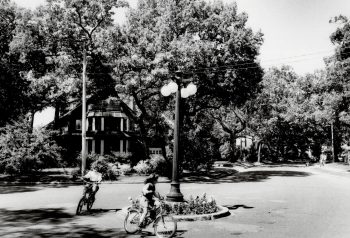
The District has historic and associative value in connection with Robert Home Smith, a prominent Toronto businessman who developed the area as a “Garden Suburb” in the early 20th century. The Garden Suburb was a planning method that was popularized as a reaction against growing industrial cities and facilitated through transportation improvements that allowed the mobile upper middle class to live outside the urban centre. The bucolic nature of the District’s setting overlooking the Humber River, its winding street patterns that in large part follow the promontory’s topography, varied lot pattern, generous landscaped yards surrounding its period revival homes and extensive parkland result in a unique picturesque neighbourhood. Garden Suburbs were intended to evoke an earlier, pre-industrial time period as a counter measure to urban Victorian life. The District and the Garden Suburb movement are more closely related to North American precedents, including Llewellyn Park (New Jersey), Riverside (Illinois), Lawrence Park (Toronto) and Forest Hills Gardens (New York).
The District has social and community value for Indigenous nations as peoples who have an enduring connection to this land and river from time immemorial. The inherent spirit of this land connects contemporary Indigenous communities to their ancestors who used the Humber River and the Carrying Place Trail, and who lived in Teiaiagon generations before.
Important gathering places in the District also hold social and community values and include the three parks (Magwood Park, Etienne Brule Park and Part of Cashman Park), the Baby Point Gates, the Baby Point Club, and the Humbercrest United Church.
The District has contextual value for its views and access to the Humber River, its tree canopy, and its topography. These landscape features create a shared strong sense of place for all communities and holds specific importance for Indigenous peoples.
The District’s contextual value as a Garden Suburb is reflected in its homes that date from the Home Smith building period (1911-1941), during which time design restrictions were put in place to protect the character of the neighbourhood. These restrictions ensured the construction of single-family homes with high-quality materials and the conservation of the area’s park-like setting. The streetscape of the District as envisioned by Robert Home Smith remains, with curvilinear streets that follow the promontory’s natural topography, as defined in the Humber Valley Surveys, a collection of Garden Suburb neighbourhoods along the Humber River.
The District’s natural values are based on its picturesque character and landscape features. Indigenous peoples continue to value the forests, river, plants, and animals in the District. The District’s natural values are defined by its park-like setting, supported by, and reflected in the front yard setback of houses, the siting of houses that were positioned to preserve the tree canopy and natural topography, the surrounding public parks, and the Humber River.
The District’s design and physical values are embodied by the early 20th-century residential buildings that reflect the popular revival styles that were built within the planned Garden Suburb, which was itself part of the larger Humber Valley Surveys.
The design and placement of the homes reflect the regulations established by the Home Smith Company which dictated their style, materials, and siting to preserve the neighbourhood’s picturesque and bucolic character. The overall scale of the District is defined by a predominance of two to two-and-a-half storey houses, with more modestly sized houses on Baby Point Road between Jane Street and Humbercrest Boulevard, and larger houses on the promontory. The District has a unique layout, comprised of a straight road that splits into curvilinear streets, reinforcing a perceived transition into nature that reflect Garden Suburb design principles.
Houses in the District were designed in architectural styles reflective of early 20th-century trends in upper-middle class housing and are primarily English Cottage (with Tudor influence) and Colonial Revival (with Georgian and Edwardian influence) in style. The material palette imposed by the design restrictions is evident in the District in that most houses feature brick, stone, concrete or precast concrete, and traditional stucco. Many of the later additions and infill housing continue to incorporate these materials.
The cultural heritage value of the District is expressed by the following heritage attributes:
The revised proposed Baby Point HCD Area includes the Baby Point residential neighbourhood, located on the eastern banks of the Humber River north of Bloor Street West, generally accessed from Jane Street at Baby Point Road and Humberview Road, as shown on the map below.
All properties within the HCD are designated under Part V of the Ontario Heritage Act. The Baby Point HCD Plan will include policies to conserve and manage change. These policies differ based on whether a property is considered “Contributing” or “Non-Contributing”. All properties within the proposed Baby Point HCD were individually evaluated to determine whether they have features that support the identified cultural heritage value, heritage attributes and integrity of the HCD.
The properties that have these features are “Contributing” properties and those that do not are “Non-Contributing” properties. The majority of the properties in the District are “Contributing”. Determining whether a property is “Contributing” or “Non-Contributing is independent of its archeological potential and presence of landscape features.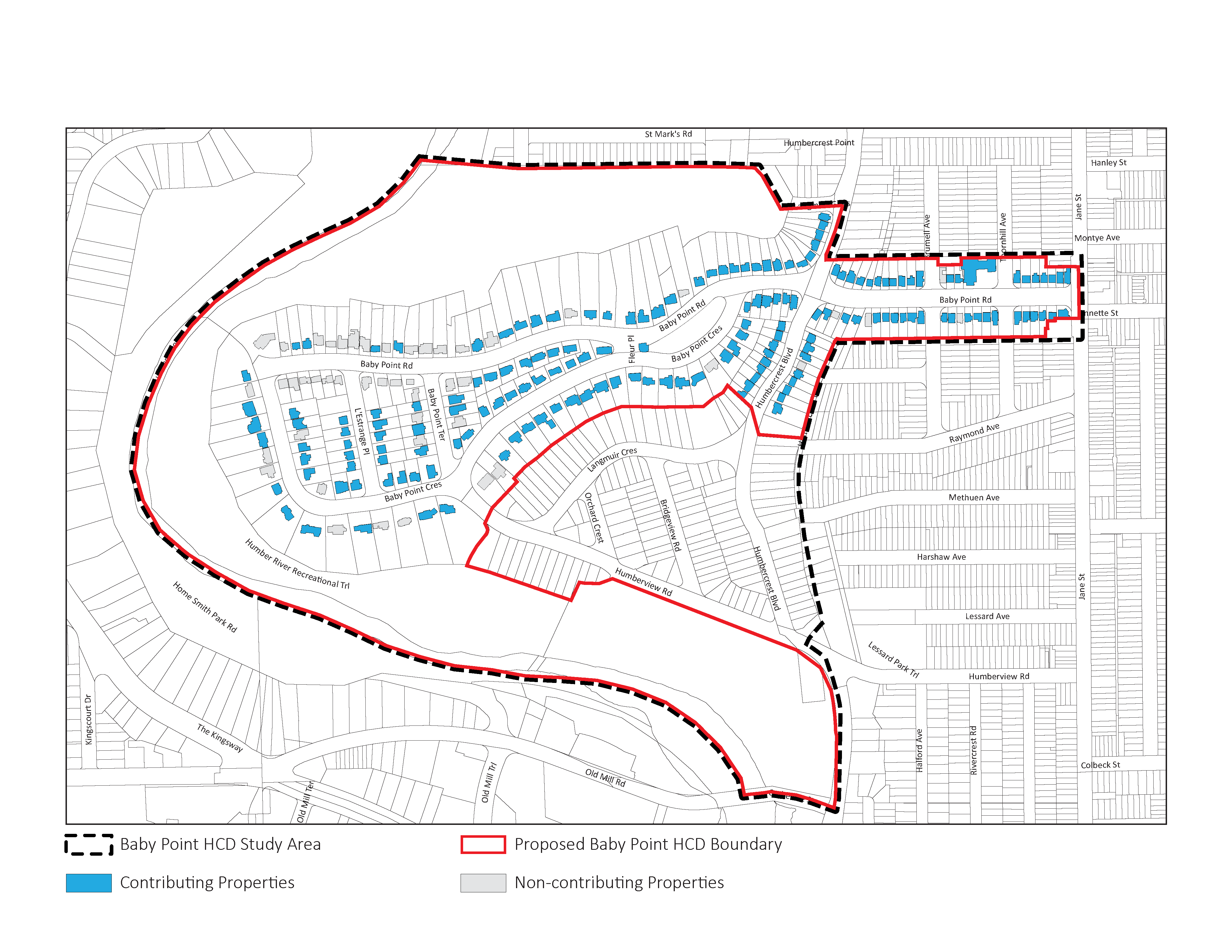
The HCD Plan process was initiated in Spring 2021. The Teiaiagon-Baby Point HCD Plan was adopted by City Council on December 18, 2024.
As part of the engagement with First Nations communities during the preparation of the HCD Plan, the project team decided to undertake revised historical research for the area in order to better reflect Indigenous community perspectives.
The Teiaiagon-Baby Point History and Evolution dated December 2024, by EVOQ Architecture, ASI and Eric Wright, reflects the updated historical research and input received from First Nations on the history of the area.